The photos above celebrate Wyoming’s great parks: Devils Tower, Fort Laramie, Fossil Butte, Grand Teton, the Rockefeller Parkway, and Yellowstone (more photos in that post). Bighorn Canyon is partly in the state, but my photos are in Montana. The Pioneer Trails and the Pony Express also pass through Wyoming, and Cody has a spectacular museum on Buffalo Bill, Native Americans and more, unrelated to the NPS.
Photography
South Dakota in Photos


Quick bonus post to celebrate completing all the parks, trails, et cetera in South Dakota. The photos above are from the Badlands, Jewel & Wind Caves, Minuteman Missile and Mount Rushmore. The Missouri NRR borders the state and includes Yankton’s Meridian Bridge, which is nice for walking or biking and has a good kayak launch nearby. Lewis & Clark stopped here too, and there are several sites on their trail where the Yankton tribe showed them around South Dakota.
Pacific Crest National Scenic Trail

The trail runs from the California border with Mexico up around LA to Sequoia and Kings Canyon, through Devil’s Postpile, Yosemite and Lassen. Then it continues up to Crater Lake in Oregon, crosses over the Lewis & Clark trail on the Columbia River into Washington, past Mt Rainier, to the high bridge (see photo) between Lake Chelan and the North Cascades, crosses the Pacific Northwest trail and finally crosses the Canadian border.
The PCT is 2,650 miles and grew out of Clinton Clarke’s idea in the 1930s to link existing trails to create a border-to-border extremely scenic trail. Although in 1968 it officially became one of the two first national scenic trails—along with the 2,190 mile Appalachian Trail—, the PCT wasn’t completed until 25 years later. It’s a foot trail (e.g. horses), no vehicles (e.g. bicycles). Having visited all the parks and many of the national forests wilderness areas along the trail, including places photographed by a PCT founder named Ansel Adams, it’s one of our great national treasures.
Fort Point National Historic Site

The Civil War era fort was obsolete as soon as it was built, since rifled cannon penetrated brick walls, and the one threat it faced, the CSS Shenandoah via the Indian and Pacific, called off their mission when they learned the war had ended months earlier. (They spent their round the world voyage attacking whaling ships out of New Bedford, since they often had escaped slaves on their crews.) Before that, there was a Spanish fort here, which was taken over by the Mexicans and then by a band of Americans including Capt. Fremont and Kit Carson, shortly before California became a state.
These days, it’s best used as a place to get a nice photo of the Golden Gate Bridge (when it’s less foggy). The fort is open on weekends, and you can get a good photo from the roof. I walked down from Battery East, but walking or biking from Crissy Field is nicer. There is parking at the fort, although it requires persistence navigating, since more roads are open to bikes than cars around here.
Hovenweep National Monument

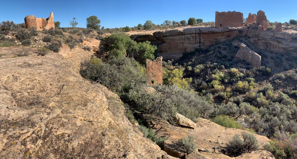
Hovenweep Castle to the right and the Square Tower in the middle were likely part of a connected, multi-story pueblo, part of a complex of buildings surrounding this small canyon. 750 years ago, the farmers who built and lived in this castle grew corn, beans, squash, amaranth and probably cotton. They kept domesticated turkeys in the canyon and built small dams to control flash floods and enrich soil. The 2 mile round trip Little Ruin Trail is easy to follow to photograph the varied ruins from different angles.
Maybe if I had come out west here before visiting Europe, I would not have told my host family that we don’t have any old stone castles in America. This is an extremely photogenic place, and I was happy to walk the loop in the morning, before others arrived. The drive through the Canyons of the Ancients National Monument (managed by the Bureau of Land Management) and on ‘reservation roads’ is worth doing slowly.


