Congaree National Park

Congaree is one of my favorite parks, so I saved it for my last entry of the year. Once, every river in the southeast was filled with hardwood forests like this, supporting many species of birds, fish and wildlife, and keeping our air and water clean. Now, this may be the last great one left. Around late May, the fireflies blink in synch, so you’ll need to plan months ahead if you want a campsite then. The 2.5 mile boardwalk hike from the main Harry Hampton visitors center takes you past a few of the tall trees that fill the swamp: beech, bald cypress, water tupelos and loblolly pines. The latter are the largest, most massive pines in the eastern half of the US. Congaree may have been saved much more recently than some of the more famous parks in the west, but for biodiversity, it is exceptional.

Of course, being basically a swamp or flood plain forest in the middle of a giant watershed stretching from the Blue Ridge Mountains to the Atlantic, the best way to see the park is by paddling. I dragged out my trusty OruKayak and spent several glorious hours exploring Cedar Creek by myself. There were folks on tour at the boat launch, but once on the water, I didn’t see anyone. Longer trips can be arranged on the Congaree River. Several people asked about my kayak, including a couple that happened to be from my old hometown, and I explained that it is lightweight, a bit tippy, and fits easily in the trunk of my Tesla Model 3. (I know everyone is hating on Elon right now, but he made a good car, as long as you don’t use the autopilot).

Apologies for botching another photo, but I should point out that the knobby things sticking up from the bank on the left are the knees of the bald cypress. They say it’s a mystery why the tree has knees, but obviously, the knees help dry out the roots, preventing rot. Above them, you can see some dwarf palmetto illuminated by the sun, and further upstream, the creek was blocked by falling trees, which are becoming more frequent with climate-crisis fueled storms. I also heard a variety of birds, although most of them flew away as I approached. Definitely worth bringing a map & GPS, since there are many side routes and obstacles that may require changing plans on the water. Beautiful.
Chattahoochee River National Recreation Area

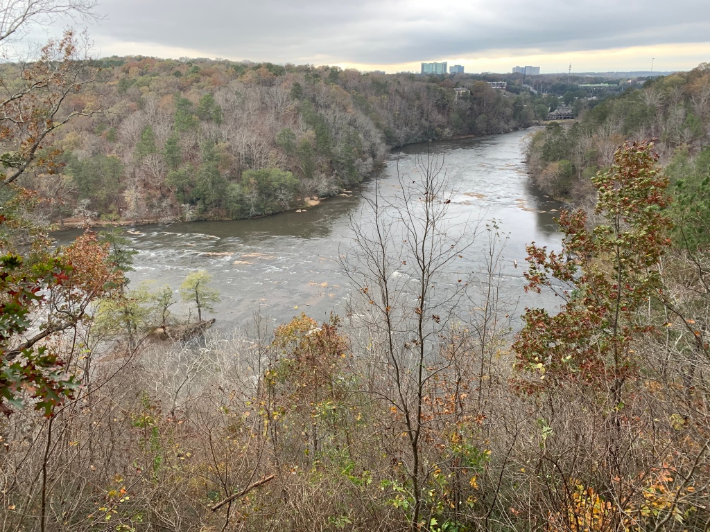
The park runs along the riverside in 16 different mostly contiguous sections, just north of metro Atlanta. The view above is from an overlook in the East Palisades section, specifically between EP 10 and EP 14 near the Indian Trail entrance. The treacherous whitewater mild shoals in the river above are known as the Devil’s Race Course, not for downstream paddling difficulty, but because it used to be “a devil” to move cargo up the river here.

Parks near urban areas means more people enjoying nature, and even on a chilly autumn day there were plenty of folks out jogging, hiking, biking and dog walking. One young lady appeared to be in deep meditation at the river’s edge, while her dog intently watched some geese on a sand bar in mid stream. It would have been fun to kayak through the park, but I couldn’t figure out a good way to get all my gear back to my car. With limited time to visit other sections, I spent my time on a beautiful long hike along the river and up in the wooded hills.

Crunching through the leaves reminds me of running cross country as a boy during the fall in New England and leaves time to reflect on loss and letting things go. Life is not perpetual youthful summers, and the decay that comes with the passage of time prepares the ground for new life and the next generation. The bittersweet changes of seasons and life should be learned from, embraced and cherished, not denied nor medicated away.

“Good night, good night! Parting is such sweet sorrow,
That I shall say good night till it be morrow.” 

— Juliet

Potomac Heritage National Scenic Trail

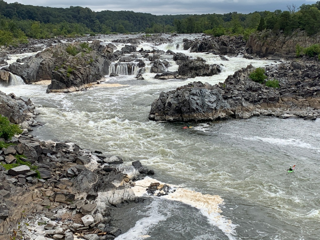
[When planning my trips for next year, I realized I skipped my September visit here. Sorry it’s out of order.] The kayakers have the best views of Great Falls, and they helpfully show the scale. The falls themselves are rated V+, meaning lethal, but there are less dangerous sections of the Potomac nearby. From the C&O NHP right across the river, it’s a 30 minute drive to get over here to the Virginia side of the falls. There are miles of beautiful hiking trails along the river with many deer that are used to people.

The PHT proper is on the Virginia side from above Great Falls down to Prince William Forest with the Mt Vernon Trail in the middle. But the broader PHT also includes the Potomac River itself, the C&O, Laurel Highlands (between Johnstown & Fort Necessity), the Great Allegheny Passage, the Civil War Defenses Trail in DC, the Mt Vernon Trail and the Southern Maryland & Northern Neck PHT Bicycling Trails on both sides of the Potomac. While I plan to visit more of those next year, it occurred to me that I may have already seen the most scenic section above. So, in case I don’t have enough time for a longer paddling & bicycling trip between Pennsylvania and the Chesapeake Bay, consider this my official park visit.

Little River Canyon National Preserve

One popular question is itinerary planning, which is essential, although my plans never survive contact with the road. The same trails must be picked up again in different seasons, and inevitably, they retrace the steps of early Americans. The old hunting grounds, early trade routes, forts and battlegrounds often overlap in places like this, and, especially when they’re preserved in a more natural state, it’s easier to imagine those who came this way before us.

After their long history of interacting with the Spanish, French and British in the southeast, five tribes had become accustomed to European ways enough to be called “civilized”: the Choctaw, Chickasaw, Creek, Seminole and Cherokee. But the US government forcibly removed them to Oklahoma anyway. Most crossed the Mississippi near Memphis, as I did. The Cherokee were split into three groups: the old settlers who moved west before the removal, those forced to walk the Trail of Tears, and those who escaped removal and still live east of Great Smoky. Here, at a natural crossing point through the canyon palisades, the couple in the photo above walk on the Trail of Tears, near where Cherokee families were rounded up into a wooden palisade known as Fort Payne.

The park helps preserve that history, although the primary mission is to protect the many species that live in this important nature sanctuary. The canyon is known among rock climbers for the challenging cliffs, and if you hike downstream there’s a swimming hole near Martha’s Falls. The river isn’t runnable by amateurs, so stick to the scenic drive along the rim, admire the views from a half dozen overlooks and try not to miss the peak foliage like I did. The road isn’t wide enough for both bikes and cars, and, as usual, the former lose out. There’s a park film at the friendly visitor center and an Ol’ Tymer’s BBQ nearby.

Time for me to get back on the road. I passed through Muscle Shoals on my way here, but now I have Georgia on my mind. Places like this are bittersweet, when you reflect on the past or consider the future, but that’s what enriches travel. And our choices make a difference too. Supporting Native American businesses, for example, seems the least we should do to recognize past wrongs. And unless we stop our carbon pollution, these small sanctuaries will prove insufficient to preserve diverse species for any who may follow us.

Chickasaw National Recreation Area

While the Lake of the Arbuckles is popular for wasting gas zooming in circles on the water, I think the hiking is the best form of recreation here. The smaller Veterans Lake is reserved for paddling, but since you can see everything from the boat ramp, there’s no point. I hiked for a couple miles near the Travertine Nature Center through the ecotone that ranges from Redbud to Cactus, along the CCC developed creeks and mineral spring pools, admiring the foliage, the tall Sycamores and various Oaks, and I watched an armadillo digging around in the brush. There are half a dozen simple campgrounds, and when the water is flowing there are many small waterfalls and an old pavilion where they used to bathe in mineral waters. Once tourists observed bison wallowing in the muddy pools, but now the area suffers in man-made drought.

To prevent over-development, the Chickasaw and Choctaw nations sold the springs and surrounding forest to the Interior Department, hence the name. I very much recommend visiting the neighboring Chickasaw Cultural Center, which connects to the park by the pedestrian Inkana Bridge. There I observed a pair of Great Blue Herons, admired the pollinator gardens, toured the replica village, watched a stomp dance, and learned about the tribe in their beautiful museum. The history of the Chickasaw is tragic, fascinating and inspiring, including conflicts with the Spanish, French, British and the US. My trip to the southeast goes in the direction their ancestors traveled many centuries before the tribe was removed to Oklahoma.