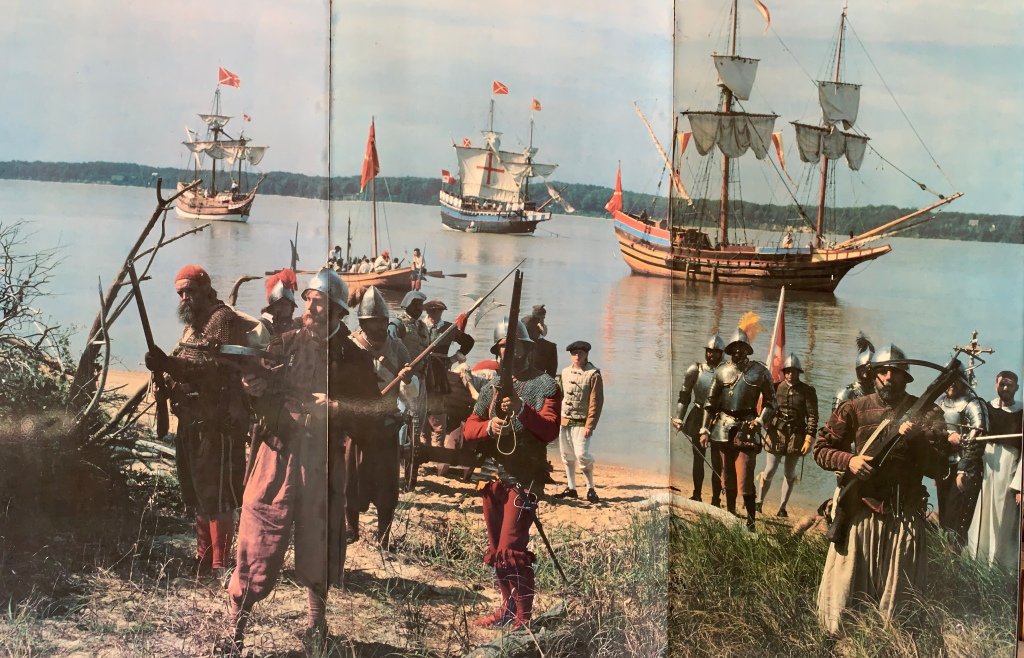
De Soto National Memorial

While the park unit is small, it is excellent, with knowledgeable rangers, many of these photographic outdoor displays, and an easy nature trail with beautiful birds along the Manatee River. There are frequent interactive events here, and the film in the visitor center is particularly well done, covering the important history of De Soto’s exploration and conflict with Native Americans.

The Spanish expedition from 1539 to 1543 was a brutal failure that cost De Soto his life and fortune, and it was his fault. After helping plunder the Incan Empire (Peru) in 1533, De Soto used his stolen gold to bring more Spanish soldiers to Florida to look for more gold. Some of the natives had recent run-ins with similar Spaniards, so they kept telling him, ‘sure, there’s more gold, but it’s a little further north’. Guides who failed to deliver the promised gold were killed. (Coronado was on a similar mission at the same time further west). De Soto took hundreds of natives captive as slaves, gave the women to his men, slaughtered thousands and told the natives that he was a deity, oh, and he brought a Catholic priest (see far right). For years, they marched through the southeast, killing, burning, pillaging, enslaving, raping and spreading disease. Many of the natives fought back, mimicking some of their brutal tactics, including the Chickasaw, who later owned slaves and fought for the Confederacy. After De Soto died of fever, his men gave up on his fruitless hunt for gold and maybe half made it back.

As horrific as that all was, several of the survivors wrote accounts of their first contact with the natives, and some of those accounts provide rare descriptions of the native cultures that existed (until the Spanish arrived). De Soto actually found an interpreter from Seville who had been adopted by a local tribe after his expedition starved to death, but he later died on this new expedition. One survivor’s record clearly states that a nearby shell mound was the foundation for the local chief’s dwelling, proving that the mounds in Florida were not simply middens but were built intentionally as elevated platforms for important people and functions, contradicting the park film at Canaveral. A large mound on this site was removed for building roads, before the park service began protecting them. After all the death and destruction inflicted on the natives, it feels especially cruel to erase the last remaining remnants of their culture without acknowledgement.

Canaveral National Seashore

Florida is famously flat, but above there’s an impressive view of the beach, lagoon and islands from the top of Turtle Mound near the Apollo Beach visitor center. There’s a kayak trail through the lagoon with campsites, and further south, there’s a scenic drive and nature hike in the neighboring Merritt Island National Wildlife Refuge. The Timucuan people who built the mound disappeared under Spanish rule—from 40,000 to “a handful” in the 18th century—, so they can’t tell us why they built these mounds. Talking with the ranger and watching the park film, I was told that the shell mound was simply a midden, or dump, from the large feasts that the Native Americans enjoyed here: “only trash”.

I said, “really” and asked why anyone would pile their empty shells 40 feet high when they could just toss them in the water? These mounds survived centuries of hurricanes, before most were excavated to build roads. The Spanish used the shells to build strong “tabby” forts. So isn’t it likely that this sturdy, flat-topped platform next to a trade route with views for miles was built for some structural purpose? I was told “no evidence for that”.

Clearly the park film and the ranger underestimate the Timucuan. It takes no great leap of imagination to realize that Native Americans shared common cultural customs and built large mounds for ceremonial, funereal, calendar and other purposes. See Poverty Point, Ocmulgee, Cahokia, Hopewell and Effigy. Ignoring the pattern takes willful blindness and shows a lack of respect for Native American culture by the people who now live here.

Anyways, I had to be out of the park before the night launch of Artemis I from the Kennedy Space Center next door. NASA preserved this largest undeveloped Atlantic coast, and the seashore, lagoons and waterways host critical ecosystems for fish, birds and more. The endangered Right Whale winters off the coast, and the vulnerable West Indian Manatee breeds, raises young and migrates seasonally. In the warmer months, manatees can be seen at the Haulover Canal or from Turtle Mound. Some manatees winter in the discharge of a nearby natural gas electric plant, but most winter in natural hot springs like Blue Spring State Park, where I hiked their cypress swamp boardwalk to the deep blue hole and found a couple early ones. The manatee’s natural territory is much larger than the park boundaries. Some boaters disregard Slow signs, support removing all safety zones from rivers and even advocate legalizing lethal manatee strikes, just so they can bomb around in their noisy carbon polluting toys. We need to learn how to coexist with nature, not kill it.

Cahokia Mounds

Tens of thousands of Native Americans lived in this city 1,000 years ago, and it was the center of the Mississippian culture that thrived in the valley and as far as Ocmulgee in Georgia. In the distance from atop 100′ high Monks Mound (named for French Trappist Monk settlers), you can see Gateway Arch. This is the largest Native American mound north of Mexico, and it is still an impressive, tiered, geometric structure surrounded by 50 other smaller mounds of different shapes and sizes, for burials and as foundations for public buildings. There’s also an astrological calendar circle with wooden post markers, called “Woodhenge”.

Cahokia is actually both a state park and a UNESCO World Heritage Site but not a national park site. However, it is on the Lewis & Clark National Historic Trail, and Illinois’ Senators have asked President Biden to make it an official national park site. It’s simply too big to ignore, so, I stopped and climbed, even though the visitor center is closed.

Poverty Point National Monument

Over three thousand years ago, Native Americans built something massive here with over five million man-hours of labor. I took the photo from the top of the largest bird-shaped mound built over 700 feet wide and 70 feet high. There are additional mounds in a north-south line as well as a series of three parallel ridges, forming an octagonal plaza 3/4 of a mile wide. Tools found here show that materials came from all over the greater Mississippi watershed. Artifacts show refined stonework, fired clay crafts, beads, and detailed figurines. Topography and excavation show signs of a quarry, dock, swales and a causeway, demonstrating sophisticated engineering techniques and planning for the Late Archaic. The north-south lines suggest calendar knowledge, perhaps for agriculture.

This park is another UNESCO World Heritage Site and is managed by Louisiana which charges a small fee, despite also being a NPS unit. I doubt many Americans are familiar with this site, which dates back to the Shang Dynasty in China, the first Dynasty of Babylon, the expansion of Egypt and the Ancient Greeks. Certainly it belittles the lie that the Native Americans never built anything.