Capitol Reef National Park

The dome in the middle reminded folks of the US Capitol, but the geologic speciality of the park is the reef, or Waterpocket Fold, one of the longest continually exposed monoclines (like a wrinkle) in the world, almost 100 miles north to south. Cathedral Valley in the north and Muley Twist Canyon in the south are difficult to access without a high clearance 4×4, but the geologic layers can all be seen in the middle cross section near the Fruita orchard. The Hickman Bridge trail above is a good place to see the dome, but the scenic drive along the fold is exceptional. The unpaved side trip into Capitol Gorge is particularly striking, and there’s a hike from the parking lot up to see the eroded round water-pockets for which the fold is named.

This is a great park to learn about the geology of the west, from the high country mountains like Great Basin and Rocky at 12,000 feet, to the high plateaus like Cedar Breaks at 10,000 feet and Bryce at 8,000 feet, to standing up country with Natural Bridges at 6,000 feet, Arches at 5,000 feet, Zion at 4,000 feet and the many layered Grand Canyon spanning from 8,000 to 2,000 feet, and all the way down to the low desert of Death Valley more than 250 feet below sea level. Here, the ranger’s geology talk explained how the changing climate and continental shifts over hundreds of millions of years left repeated layers of deposits, lifted them up unevenly and eroded them into the wonderful scenery we see today. The same patterns repeat, not just one ancient inland sea or forest or swamp or grassland or desert, but many repeated environments were slathered over one another and pressed into rock.

Why are there weird discolored greenish mounds along the Green River? Those were from one of the swampy periods (Morrison) when oxygen was low, materials were soft and clay-like and they contain late Jurassic dinosaur fossils. Why are there similar colored layers at much different altitudes? They were from different swampy periods and contain different fossils. What causes the alternating pink and beige layers of hoodoos and other rock formations? The layers are made of the same kind of rock, but in some years the iron oxidized and in others it couldn’t due to water changes. Where did all the sand come from to make all the sandstone layers? Much of the sand eroded from the old Appalachian Mountains, flowed down ancient rivers and blew across to the west.

Even if you’re completely uninterested in Geology, you might be interested in the outlaws who hid in the remote areas nearby, like the Wild Bunch, which included Butch Cassidy & the Sundance Kid. Or maybe tour the old orchard and learn about pioneers. Or take a moment to think of those Uranium miners, many Native Americans, who still suffer radiation poisoning, or think about the wildlife who can’t read the warning signs. This is an uncrowded and under appreciated national park. Highly recommended.

Arches National Park

Landscape Arch above spans over 100 yards. Photographs fail to render the three dimensional features. Only by hiking up the trail, turning that last corner and wandering around to view from different angles do the arches reveal their true nature. My head was spinning trying to take in the detailed patterns on rock faces, judge the sizes of dramatically shaped features, imagine the geologic timescale and focus on the variety of terrain in every direction at different distances.

The reason there are more arches here than anywhere else in the world is salt. As elsewhere, the land formed in layered deposits, rose up and eroded. The unique part was that there were more layers of salt from shallow inland seas which slowly migrated underground and piled up against a hard fault line, forming an unstable underground salt dome that liquified and caused many long straight vertical cracks in the rock layer above. The exposed fins of sandstone eroded from both sides forming many arches and small windows. (Bridges are entirely different than arches).

In theory, the most famous arches are easily explored. Only a few miles from Moab, the main park road climbs up through the dramatic red canyon and branches off towards Delicate Arch above a salty valley, past Balanced Rock towards the Windows and up above to the Devil’s Garden. Each area has parking, and many of the trails are easy. In March, there were only a few visitors in the morning, and every arch waited patiently for me to admire. But by April the park requires timed reservations due to crowds, and in summer the heat can become dangerous. So in practice, you should time your visit thoughtfully, especially if you want to capture sunrise or sunset views without crowds.

Cedar Breaks National Monument

I hiked out here 2 miles round trip to Spectra Point to get a view with Bristlecone Pines, so that you can tell this is not another photo of Bryce. There are a number of Bristlecone Pines here and a few more near Chessmen Ridge Overlook, although they are likely younger than some at Great Basin. By the way, if you’re looking for cedar trees, there never were any. Early visitors from back east mistakenly thought that the juniper trees were cedars, and the misnomer stuck. Cedar Breaks is over 10,000’, so it’s a step or two above Bryce, but since it extends down through and exposes the same layer of rock, it looks similar near the top. The view down the gorge looks down over 5,000’ towards also misnamed Cedar City, so you get a good look at the various layers of the grand staircase. Be careful hiking here, as high altitude contributes to vertigo. Due to the heights and erosion, there aren’t any recommended trails down from the rim, but there are a few rim trails and seven overlooks, four of which are near parking. While the road and trails may still be open, there was frost on the trail when I visited, and the roads will close as soon as it snows. The temporary visitor center and store has now closed for the season, and the new visitor center at Point Supreme Overlook is still under construction. Hopefully it’s open next year.

Bryce Canyon National Park

This view is of Bryce Amphitheater from Bryce Point in the morning. Below are the 5.5 mile Peekaboo Loop, 1.3 mile Navajo Loop, 1.8 mile Queens Garden and other trails through the hoodoos. Definitely do at least one hike, if you’re able at this altitude, or even better, book a trail ride from the lodge. I won’t ever forget the spectacular feeling of riding through a layered maze of brightly colored hoodoos with my family; it is one of the best park experiences I have ever enjoyed.

There are around 15 different trails and as many overlooks, including Mossy Cave, Natural Bridge, Rainbow Point and Fairyland Point. Carbon burners should stay home or at least park and take the free shuttle, which goes from the hotels and campground near the entrance to the lodge and the most popular viewpoints and trailheads, but, since the shuttle is not yet electric, I drove my EV around early.

Bryce Canyon is between 7,500’ and 8,500’, and it is one of the prettiest places to appreciate geology. Long story short, the inland sea dried up, the land rose and erosion created the hoodoos and the rest of the canyons in the area. Grand Canyon is the bottom of the grand staircase, Zion in the middle and Bryce near the top. The colors of the steps span from ancient dark rock, tans, chocolate, vermillion, marble, to pink and white. And, if that’s not enough, it’s easy to see mule deer and other wildlife, wildflowers and to appreciate the dark night sky.

Natural Bridges National Monument

The Bridges, so designated because water flowed through them and formed them, are much older (Permian) than Utah’s famous Arches (Jurassic). There are three main bridges to see here, each only a short hike from the scenic drive to view, and they span two canyons, Armstrong and White. The Owachomo Bridge above is over a dry creek bed and can easily be hiked under. The Kachina Bridge is at a more challenging viewing angle near the intersection of the canyons, but if you’re up for the Loop Trail hike, I bet it’s spectacular. Sipapu Bridge, second in size only to Rainbow Bridge, is named for the emergence gateway mythology common to Native American tribes. There’s an impressive view from the overlook, and if you hike and climb about halfway down and go out along a wide ledge, you can get a view from the other side, which is equally magnificent.

Unfortunately, none of the bridges were working as portals to distant past or other dimensions. The surrounding forest and beautiful canyon lands are part of the Bears Ears National Monument (managed by the US Forest Service and the Bureau of Land Management), and the mesa top buttes that look vaguely like ears from a distance can be seen from the parking lot as well as from miles away in several directions. I drove in from the east, stunned by the scenery, and then left south, where the road drops into Monument Valley. Wow.

“I’m pretty tired…. I think I’ll go home now.”

Forrest Gump

Alibates Flint Quarries National Monument

This little lady is an Eastern Collared Lizard, and she’s sitting on Alibates flint, which is an extremely hard and unusual type of flint used by Native Americans for sharp edged tools. These flints were used to hunt Mammoths (possibly to extinction) by the Clovis people over ten thousand years ago. (Clovis is the New Mexican town where they were studied). Successive groups of natives used these flints, notably the Antelope Creek tribe, who dug hundreds of quarry pits around here to dig out the best quality, unweathered flint, and traded them as far as Montana, California, Mexico and Alabama.

I’m not particularly interested in geology, but this was the funniest parks tour I’ve taken. The ranger, Ben, somehow got ten strangers roaring with laughter in ~100 degree heat while climbing a hill to look at rocks and taught us all lots of interesting facts along the way. He even got a Texas Horned Lizard (or “horned frog” or “horny toad”) to scramble in front of us, so we could all get a good look at the official lizard of the state. Actually, the only way into the park is by guided tour, and the only tour during the heat of summer is at 10am. Better to call and make a reservation.

If you are into geology, then this park is fascinating. There’s petrified algae, iron rich red beds, fossilized dolomite, salty gypsum, and of course the multi-colored, sometimes sparkly, agatized dolomite, known as Alibates flint. That name came from a cowboy guide named “Allie Bates”. Mysteriously, perhaps from Valles Caldera or Yellowstone volcanic activity, there was an abundance of silica-rich water that seeped into the dolomite and crystalized into a dense quartz along with an array of other colorful minerals. The flints have many of the rich colors and patterns of the mineralized trees found in the Petrified Forest.

I stayed the night in Palo Duro Canyon (2nd in size to the Grand Canyon) which is another great location for views of the colorful red, white, orange, and yellow rocks under a blue sky with lots of different green trees and plants. The night sky was also brilliant. Any recent rain can close roads though. There was a summer musical playing there for Texans about how wonderful the history of Texas is, but of course, it glosses over the theft of native lands and doesn’t mention slavery at all. It never occurred to me that Texans would be so insecure.

Timpanagos Cave National Monument

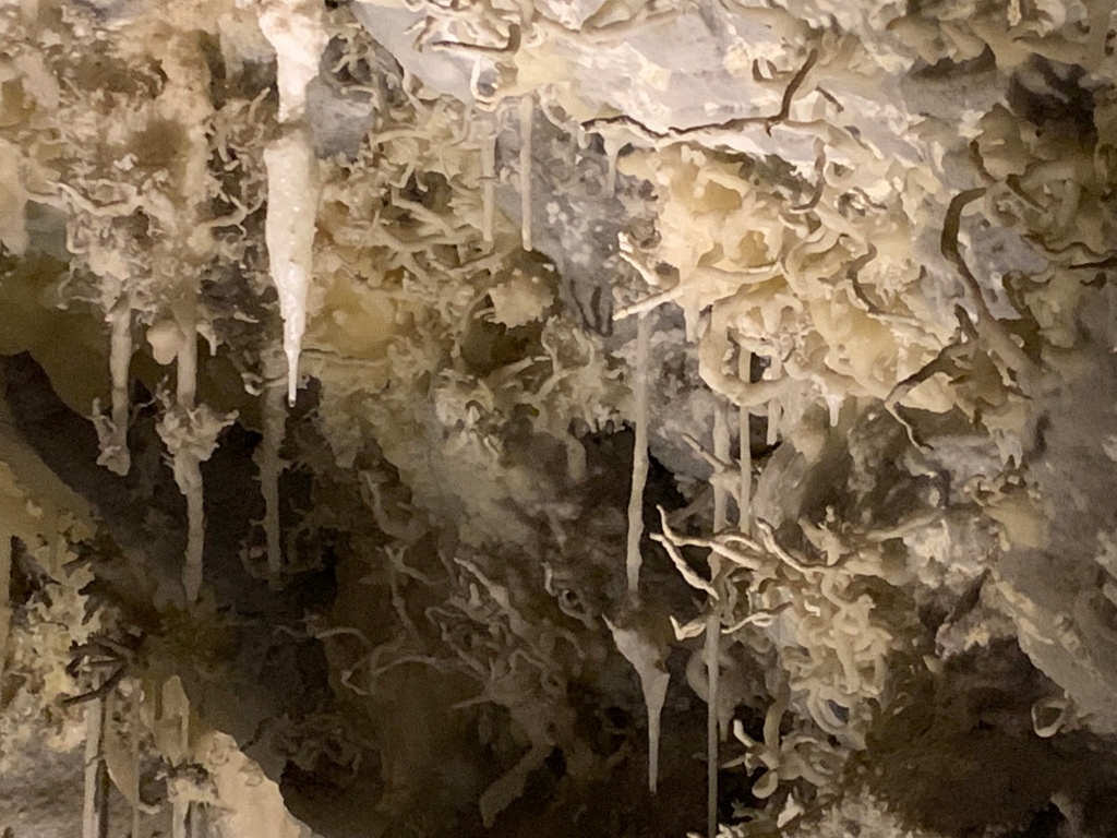
The cave is famous for its helactites, the squiggly ones that seem to defy gravity. To see them, I’d recommend a reservation or getting here early (open at 7am), as they do sell out. Then, walk up the switchback trail for 1.5 miles, and be careful not to wander off the near vertical drops while you gawk at the stunning views. The gap between the mountains appears to be deeper than it is wide, and there’s a river flowing through a forest at the bottom along with the road. Don’t mind the many hikers. They’re probably just out for exercise, as one lady told me her friend had climbed it over 100 times. And I suspect they exercise regularly with mountain goats here, since I also saw two moms carrying two kids each with more in tow.

The regular tour is ranger led and includes three sections of cave. The middle section has a crack in the ceiling which has dripped water for ages to create the amazing structures: flowstone, soda straws, popcorn, bacon, small crystals, stalactites, stalagmites and columns, in a variety of colors. We also saw a party of explorers with caving equipment entering small passages, which is another tour option for the skinny and flexible.