Amistad National Recreation Area

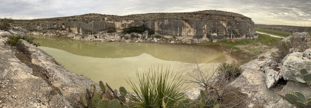
In 1969, just below the confluence of the Rio Grande, Devils and Pecos Rivers, a dam was built, creating Lake Amistad (friendship en Español). The lake caused the mouths of the Pecos River and Seminole Creek (above) to silt up, and now that the water level has fallen (like Lake Mead and Lake Powell) they’re cut off from the Rio Grande (see far right). Most of the boat ramps, like the small dock at the cave above, are no longer accessible. The lake is far below minimum expectations, because the US diverts virtually all the Rio Grande water before it even reaches Big Bend. From there most of the river comes from Mexico’s Río Conchos. The park is run in partnership with many agencies, and the two towns that share the border are friendly and have joint cultural festivals annually. Mexico maintains a small fishery, US residents enjoy bass fishing, and the border is marked with buoys. I took one of the old highway ‘spurs’ straight down to the water, but it was too hot to kayak in winter.

Panther Cave, across the canyon above, is on the far western park boundary. While the park film absurdly claims that “no Native Americans have any ties to the area”, the canyon is Seminole Canyon, and the cave is an important site for prehistoric cave art. The Amistad visitor center has information and large reproductions of the cave art, and the excellent Seminole Canyon State Park has morning ranger-led tours to another similar cave and a few miles of hiking trails to see the view above. Before man dammed and drained the rivers and destroyed the riparian ecosystems, Native Americans must have traveled up the Rio Grande to Albuquerque, where some of the oldest petroglyph art was created at the same time as the art here. Sitting on the cliff above observing the wildlife, I imagined prehistoric people hunting, traveling by canoe, drawing on the cave walls and protecting their families from panthers, until thunder warned me to seek shelter.

Great Basin National Park

First, if you can’t get a reservation in time to visit Lehman Caves, just visit the park anyway. I took the virtual cave tour, and, I suspect that Timpanagos in Utah is better and less damaged. Besides, the park isn’t a cave park, it’s the highlight of the Great Basin area, which includes most of Nevada, western Utah and parts of three other states, and has a glacial basin of its own at the top of a 13,500 foot mountain.

Second, stop at Mather Overlook to admire the views and fall foliage of yellow and orange Aspen amid the dark green conifers. There’s a bronze model there that shows the structure of the basin, which is helpful orientation, since it is a long winding road.

Third, understand that the glacier here, “the only glacier in Nevada”, is gone. In theory, there might be some subterranean ice under some of the rocks for another couple years, but climate change has wiped this glacier off the face of the earth. The park maps showing a “rock glacier” in white are out of date. Any snow you see up there is seasonal.

Fourth, take the Glacier Trail anyway, since it goes through the Bristlecone Pine grove and up into the basin. If you only get as far as the grove (2.8 miles roundtrip), that’s what I felt was the highlight of the park. The other two Bristlecone Pine groves are in very remote areas of the park. There are also some trails to pretty alpine lakes, but be careful, as many of the hikes are over 10,000 feet. Spending the night at altitude can help, as well as give you lovely views of the Milky Way.

The Bristlecone Pine, far from merely eking out a bleak minimal survival, is a gold resinous Adonis, shining in the bright Alpine sun, with luxurious thickly packed bright green bristles. We don’t know how long they can live. One that was removed from here in 1964 was over 4,900 years old. Unfortunately, climate change will likely make them extinct, as other trees will grow at higher elevations, crowding them and subjecting them to more wildfire damage.