Cuyahoga Valley National Park

Cleveland’s mayor, the first African American elected mayor of a major city, Carl Stokes, faced an environmental crisis. The Cuyahoga River, above, caught fire in 1969. And it wasn’t the first time. Mayor Stokes led journalists on a pollution tour and tied the issue to poor and underserved communities, many of color, which often suffered most. He led the fight for change.

In many ways, this park is a great example of what can be done, when we make the effort to restore nature. While interstate highways still cross over the park, they do so from extremely high bridges, separate from the deep valley below. Many tributary watersheds are protected by municipal and state parks and other reserves. Instead of removing the old railroad line along the river, there’s a classic old train line with restored historic whistle stops for hikers, bikers, and even kayakers to return after traveling through the park one way. An old inn on the canal has been repurposed as a museum. An old mill village is now a visitor center with a store selling drinks, sandwiches and ice cream (black raspberry chocolate chip is the best). The tow path, which both separated the canal from the river and provided a walkway for teams of oxen to pull barges, makes a perfect, nearly level, dry, packed gravel path for bikers, hikers and equestrians to travel for miles through the woods, admiring both wildlife and the beautiful scenery.

I biked from Frazee House to Peninsula, above, about 20 miles round trip, in order to see some of the northern and middle sections where the path runs close to the river and far from the road. I saw both a Bald and a Golden Eagle, the first with the help of a park volunteer who let me look through his telescope. Brandywine Falls also surprised me by being larger than expected in Ohio, and the Ledges is another popular hike. I also hiked through Beaver Marsh at the southern end to look for more birds and watched a Great Blue Heron fishing for about an hour, among the geese, various ducks, redwing blackbirds, giant snapping turtles and other wildlife. Wonderful!

Indiana Dunes National Park

100 years ago, Alice Gray chose to live in the dunes above for ten years, camping out, swimming nude, and eschewing the working life in Chicago, visible across the lake. She became known as ‘Diana of the Dunes’, and more than anyone else is responsible for the park. She protested the removal of the huge sand dunes for glass, industry and fill. She urged that the dunes be preserved in media interviews and at a speech to the Prairie Club.

“Besides its nearness to Chicago and its beauty, its spiritual power,
there is between the Dune Country and the city a more than sentimental bond—a family tie.
To see the Dunes destroyed would be for Chicago the sacrilegious sin which is not forgiven.”

Alice Mabel Gray, aka Diana of the Dunes, in 1917

The park comprises several sections, including a Heron Rookery, an Ice Age Bog, seven named beaches and a lake, besides the dunes themselves. There’s an eponymous state park within the bounds of the site. The ranger suggested that the 1 mile Dune Succession Trail which includes Diana’s Dunes above is the best in the park, but the attached 1 mile West Beach Loop Trail to Long Lake is worth taking too to see more birds. I saw well over a dozen species of birds, including the American Bittern, and there were turtles and evidence of beavers as well.

Unfortunately, sections of shoreline within the park are also taken by steel mills, power plants, train stations, and development. The hum of cars is constant and passing trains drown out the birdsong. A local dog-walker explained how many nests have been destroyed and how developers always seem to evade environmental restrictions. Once gone, these homes for wildlife will never return, given the fragile ecosystems and manmade pollution. Saving species means reserving more wetlands and restricting development, but everywhere I go, most folks seem more concerned with their lawns than the Climate Crisis.

Padre Island National Seashore

I joined a few kayakers at Bird Island Basin to explore the Laguna Madre on the calm inland side of Padre Island in perfect conditions and enjoyed close up views of well over a dozen bird species fishing in the murky salty water, resting on the muddy beach and hopping around in the low grasses & brush. As usual, I wasn’t able to take good photos while bobbing along in my kayak, so here’s one I took from my car window of a Laughing Gull. With a number of birders in my family, I tried to identify at least a few of the endangered species: Reddish Egret, Least Tern, Brown Pelican, White Tailed Hawk, and at least two of their three endangered Plovers. Including the ocean side and sprawling grassland, there were Ruddy Turnstones, Curlews, Willets, a Tricolored Heron, and various ducks, sparrows, and raptors, and who knew there were so many different types of terns?

After the birds, Padre Island belonged to Native Americans first, and the visitor center and beach nearby are named after the Malaquite. The Spanish claimed it next, and silver treasure was found from one of their shipwrecks. Then the Republic of Texas claimed it, and finally the US won it in the Mexican American War. A Padre who collected funds for Rio Grande missions built a home here, prompting the name as well as the companion name for the lagoon. The Laguna Madre stretches into Tamaulipas Mexico and is the largest hypersaline coastal lagoon in the world, a critical stop on the flyways for many migratory birds in the Americas.

Prior ranching, military use and driving on the beach make the island less than pristine, but the park service has helped recover Ridley and other sea turtle populations here. There are specially adapted birds, fish, crabs, shellfish, reptiles, bugs, and other animals here, some of which live nowhere else. Unfortunately, fossil fuel drilling is still allowed in this area, which threatens all species in many ways, especially by climate change and rising seas.

Palo Alto Battlefield National Historical Park

[Note: Starting today, I’m switching to Monday, Wednesday & Friday posts to keep more up to date.]

The strange elk in the background are actually Nilgai, an Asian Antelope that escaped from a ranching project and now live in the park. In a way, it’s appropriate to start with an invasive species, since this park marks the start of the Mexican American War. In the 1840’s President Polk campaigned on expanding the country westward and as President sent troops to the Rio Grande, even though Mexico viewed it as their territory. Mexico, having only recently won its independence in 1821, was having trouble managing its northernmost territories, and lost control of much of Texas during a revolt by American settlers in the 1830’s. When Mexico’s army crossed the Rio Grande to expel the interlopers, Polk claimed that America was under attack and the war was on.

Mexico laid siege to a small fort on the north bank of the Rio Grande, and US troops were rushed in from up the coast to reinforce it. The two forces met in the middle here in a dry part of the delta. The US had better artillery, and the Mexicans had more men. The US troops were under command of Zachary Taylor, who later turned his war fame into a successful run for President, and many veterans of this battle would go on to serve in the Civil War. Lt. US Grant, who opposed war with Mexico personally, engaged in his first battle here. Between heavier guns firing more deadly shells, light guns quickly turned to face flanking attacks, and well trained US troops who engaged in hand to hand combat between here and the fort, the Mexican Army was forced to retreat. Around 100 Mexican troops and 10 US troops died in battle here.

Today the field is marked with flags and cannon to show the positions of the two sides and ‘interpretive exhibits’—small signs—to explain what happened in different places where the troops faced off. Closer to Brownsville, there’s a much smaller battlefield, the Resaca de la Palma, where the Mexican Army bravely made a stand to protect their retreat. There is a viewing platform of the resaca, meaning ‘often dry river delta channel’ (and not ‘hangover’, as the word means today). The siege of the fort was lifted, but the fort’s leader Major Brown and one other US soldier were killed in action. The fort and eventual city, Brownsville, were later named for the young officer.

Although the site only covers the first week of the war that took place in what’s now the US, the war raged on for two more years with US troops taking cities deep into Mexico, until Mexico agreed to cede Texas and sell its rights west all the way to the Pacific. Mexico lost 1/2 its territory and the US doubled in size. As interesting and consequential as the history is, the site is a well-marked field with a path for each army, so it requires some imagination and curiosity to appreciate. The small visitor center is educational, bilingual, has an informative film, and has enthusiastic and knowledgeable rangers and volunteers. But by all means go out on the battlefield, if only to see the wildlife. I saw over a dozen Nilgai, several hawks hunting in the tall grasses, a crested caracara, and more. This is a well-known area for birders.

Rio Grande Wild & Scenic River

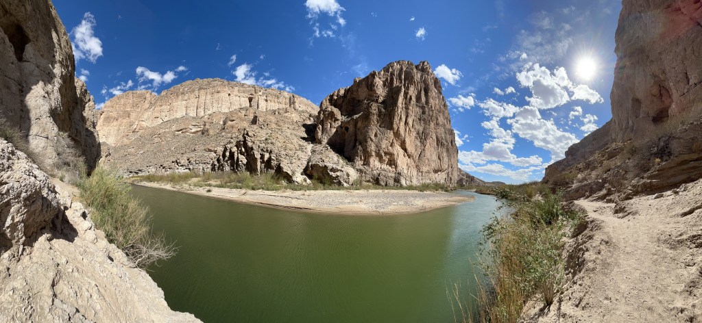
The Rio Pequeño (not grande with this low water) enters the Boquillas Canyon here and continues down to Amistad. Hiking into the canyon along the border, there are few signs of the modern world, and I suddenly felt like I was in a classic western movie when I heard horses approaching. Three horse riders offered handcrafted souvenirs and chicken tamales as they passed, and when one was crossing back to Boquillas Mexico on horseback, his horse had to bend down to knee level to drink from the middle of the river. Hardly worth crossing by rowboat at the port of entry, when folks were wading across the river. (Yeah, yeah rules, but no harm no foul with kids just playing in the water).

The Climate Crisis is playing havoc with my plans. Not sure when I’ll get the kayak wet this trip. A few days ago, I was trudging through the snow in Zion, and here in winter the temperature hit over 100 degrees on the trail. Best to visit in February, and always bring plenty of water. Last year I just carried a water bottle, but now I use a 3L hydration pack with another 5 gallon container in my car. The heat is no joke; a hiker died here just a few days ago, one more of many.

Due to low water and logistics, I’m only exploring the river from the dusty trails and grand overlooks within Big Bend. The US and Mexico protect 200 miles of land alongside the river, including the canyon above, another at Santa Elena and a big reserve on the south bank opposite Big Bend. In particular, there’s a nature trail at Rio Grande Village, where I spotted a half dozen bird species in minutes, including a Great Blue Heron and my first sighting of a Black Phoebe flycatcher. It’s unfortunate that so many communities take most of the river water without considering the downstream impact on birds and other species. I know people pay extra for golf courses, ornamental plants and water features, but national nature reserves suffer directly as a result. Americans need to invest in solar desalination facilities and leave rivers alone.

Navajo National Monument

In the center of the alcove across the canyon is the cliff dwelling of Betatakin. Due to Covid, the five mile guided hiking tour is currently suspended, but a 1.3 mile round trip hike to the the view above is open and beautiful. There’s also normally a 17 mile permitted hike to Keet Seel, a large and well preserved village, where guided tours are also currently suspended. Navajo Nation is taking a cautious approach to the pandemic, and masks are required. Please respect their wishes and culture.

Many visitors confuse this site with Monument Valley Navajo Tribal Park, which has been featured in many western films, but that site is northwest of here and run by Navajo Nation, not the park service. This park service site is in the Tsegi Canyon area and preserves Ancestral Puebloan dwellings, culture and homeland. As well as builders, they were great traders of tools, pottery, turquoise, shells, parrots and macaws. The Hopi, Navajo, Paiute and Zuni are some of the tribes that trace their roots back to this site. The visitor center has some trade items on exhibit and a gift store.

Effigy Mounds National Monument

On the Iowa side of the Mississippi River looking across from the high bluffs toward Wisconsin, there are over 200 hundred mounds, round, linear, bird and bear shaped. They are in clear lines straight out from the river, and they date back roughly 1,000 years, evidence of cultural traditions that continued for hundreds of years. Although these sites typically do not make the connection, there are similar sites along the Mississippi and other rivers at overlapping time periods with evidence of trade between them. Bird symbols in particular are found in both modern and ancient Native American culture. Many similar mounds were flattened and plowed under after the land was stolen.

The hiking here is excellent, with many overlooks, including Fire Point above and Third View which looks upriver. The hillock to the right of the path is one of the mounds, first in a long line into the woods. A pair of hawks soared high above. If you can make it a few miles, your chances of seeing deer and other wildlife improve. Since it is a sacred site, please stay on the trails and do not walk over the mounds.

Harpers Ferry National Historical Park

Since each park is unique, I would never be able to say which is my favorite. But this one is.

Here, at the confluence of the Shenandoah and Potomac Rivers, in 1859 the abolitionist John Brown led 18 men to capture the armory, arsenal, and rifle factory here, killing three men, freeing slaves and taking the town’s leaders captive, before being captured by Col. Robert E. Lee and martyred after a brief trial, becoming the first person executed for treason in America. Brown believed he was right, did not intend for anyone to die and argued at trial that “had I interfered on behalf of the rich, the powerful… or any of that class… this court would have deemed it an act worthy of reward.”

Native Americans lost this land to European settlers during the 16th and 17th centuries. Washington explored the area for his canal project and recommended an armory be built here. The armory supplied Lewis & Clark’s expedition, and the arsenal supplied weapons for the Civil War. During which the town changed hands eight times including the destruction of the arsenal, the capture of 12,500 Union soldiers by Stonewall Jackson and the critical resistance to the confederate army marching on DC. Major Delaney, the only African American field officer in that war, came from here, alongside many USCT recruits. Frederick Douglass and W.E.B. DuBois organized and lectured here, where the Freedman’s School and Storer College educated the descendants of slaves.

Thomas Jefferson stood on a rocky overlook and said “this scene is worth a voyage across the Atlantic.” The mountains, rocky cliffs, rivers, swamps, and floodplains here support diverse wildlife, including three species of hawk, a harrier and the bald eagle. There are over 20 miles of hiking trails in the park, including part of the Appalachian Trail (park & hike). And the tavern in town serves a draft amber ale called Almost Heaven.

“Almost heaven, West Virginia
Blue Ridge Mountains, Shenandoah River”

John Denver

George Washington Memorial Parkway

The green parkway along the Virginia side of the Potomac River (islands are DC) connects Riverside Park, the Mount Vernon Trail, Belle Haven Park, Daingerfield Park, Roaches Run Waterfowl Sanctuary, Gravelly Point, the LBJ Memorial Grove, Lady Bird Johnson Park, Theodore Roosevelt Island, and Turkey Run Park, so get out of the car frequently. I barely caught the Great Blue Heron flying under my footbridge, so keep your eyes open too. Great Falls on the Virginia side is a unit of this parkway park, but it’s part of C&O on the Maryland side.

Arkansas Post National Memorial

Flooding has always been an issue here. French traders established the first trading post near here in 1686, buying pelts from the Quapaw and shipping them down the Mississippi. They build a fort, which is abandoned due to flooding. Then they build another nearby and again move due to flood. After the French and Indian War, the Spanish take over the fur trade and reestablish a fort on the original location. The French get it back and then sell the whole “Louisiana” territory to the US. The post is briefly an important territorial capital, but the Union shells the confederates here during the Civil War destroying much of the town. And what’s left over becomes a backwater as the Arkansas River shifts away in 1912 and the remnants slowly erode into the bayous.

The photo shows the Little Post Bayou in the foreground and the Arkansas River in the background. With climate change increasing flooding broadly, the River has now risen again, reconnecting with the Post. Most of the history is now underwater, including French, Spanish, British, Native American and Civil War battlegrounds. But some foundations remain, along with subtle signs of confederate trenches in the woods. The post is a wonderful place to view wildlife, with many geese, a few deer, a red headed woodpecker, alligators, and a snowy egret on a tiny island in a little lake. The ranger, who loves wildlife, repeatedly assured me that the alligators here were adorable loving creatures and perfectly safe for people. I kept my distance from the large one I spotted.