To visit 16 of Mexico’s World Heritage Sites in a zero emission vehicle, I drove round trip from Texas to Mexico City, through 13 Mexican states, and, while a bit bumpy, I enjoyed the trip very much. All my trip report links are at the end of this post.
If you read online comments in the US, you might get the idea that traveling in Mexico is impossible or foolhardy at best. Well, you can’t believe everything you read online (except this blog of course). Over the entire trip, I was only asked for one ‘bribe’ of $1, to park briefly in a student parking lot without a student id. The state police, national guard and military were all very professional and waved me through either without comment or after glancing at my car permit. While I saw crime on the TV news in Mexico, I observed none.
After driving in Mexico, I finally understand driving in Texas. Instead of overpasses, underpasses and clover leafs, just use ‘retornos’ or U-turns. Folks leave the nice highways, well, they’re on their own, immediately. Want to slow traffic, without relying on folks to obey signs? Just use lots of speed-bumps or topes. Although, there are even more techniques to learn. First, always be alert. Pothole! Second, drive halfway in the breakdown lane to avoid head-on collisions with oncoming passing traffic. Third, always be alert, seriously, you need to pay attention and think while driving. Drivers are generally nice, but get out of the way of speed demons and quickly pass vehicles that wouldn’t be allowed on the roads in the US.
All Mexico is divided into three parts. Mexico City is best navigated by metro, with its one way streets, traffic and lack of parking. Traffic can be stultifying. Of course, electric cars are exempt from the Hoy No Circula—‘no driving today’—restrictions, which otherwise limit your access to the city according to the last character of your license plate. Circumnavigating the city on the ring road requires tolls: take your ticket and be prepared to pay cash (although a few places take credit cards). Remember the metro is 5 pesos or ~30 cents.
The mid-sized cities and tourist areas outside Mexico City are still crowded, but passable by private car. I was frequently fortunate to find parking very near World Heritage Sites in mid-sized city centers. Of course, the more touristy, the more likely that the roads are cobblestone. San Miguel de Allende may be magical, but I scraped the bottom of my car several times on medieval stones. Better to park outside the historic zones and walk. Still, driving your own car gets you to places that are otherwise challenging to reach.
And then there are the mountains and remote villages. Ah, lovely! But no signal to navigate. I got lost three times near the butterfly reserve. Once, my navigation asked me to drive between two trees on each side of a hiking trail. But I must admit, some of the most beautiful places in Mexico are just off the grid. Horse-driven ploughs, indigenous costumes, and forest-covered volcanoes await. Long drives are best on toll roads with frequent $5 to $15 tolls.
On this trip, I used Superchargers exclusively, and I only saw half a dozen Teslas in Mexico, including my own, mostly at chargers. Unlike the US, there isn’t a government subsidy for most electric cars, so my car was not just unusual, but uneconomical in the short run. I got few comments or looks, and the valet parking attendants had never driven one before (and didn’t like them). There are a few other electric models that I saw on TV, which we don’t have in the US, and I spotted a few of those in Mexico. But overall, electric cars are an elite affair, with parking and charging in the most expensive malls in expensive neighborhoods. I found the supercharger network from McAllen to Puebla accessible and without gaps, although it’s better to charge whenever you can, just in case you need a lot of air conditioning or have to detour.
While Mexico might seem intimidating or unrefined, the truth is that it’s worth the trouble. There are European-style cathedrals, ancient pyramids (photo from Anthropology Museum), glorious art, scrumptious food, and natural wonders that are well worth driving a couple days with the trucks on the long highways. An unexpected side benefit to driving was passing through three UNESCO Biospheres along the way: Cumbres de Monterrey, La Primavera near Tequila, and Los Volcanes near Mt Popocatépetl. I reviewed the State Department warnings and used them to plan my trip, but, again, the best way to avoid crime is to avoid drugs and be careful. Americans should take advantage of the wonderful travel opportunities just south of our border, and I’m not talking about all-you-can-whatever resorts that you fly into. See the real Mexico, and drive electric!
Three historic trails pass through the state: Butterfield, Santa Fe and the Trail of Tears. A small part of Fort Smith too is on the Oklahoma side of the Arkansas River. Oklahoma may not have as many parks as other states, but it is beautiful and moving.
Full disclosure: the three houses here were being renovated the week I was in Mexico City, and it is only on the tentative UNESCO World Heritage Site list. Architect & artist Juan O’Gorman had the complex built for the famous couple while they were touring in the US in 1931-32, and their patrons the Kaufmanns, of Fallingwater, visited the couple here in the upscale San Ángel neighborhood in 1938. The big house and studio in the front was Diego’s, the blue one was Frida’s, and O’Gorman lived in the third house in back. There’s a bridge between Diego & Frida’s homes. This arrangement worked for about 5 years, but then they divorced.
To be clear, Frida’s blue house above is not La Casa Azul, The Blue House, where Frida was born and died. That more famous one is in the Coyoacán neighborhood less than an hour’s walk away. Frida hosted Leon Trotsky there, after helping him get asylum, although he was ultimately assassinated in his home nearby (now a museum). Diego & Frida remarried and lived in her original home until her death, keeping the complex above as Diego’s studio. Diego Rivera donated Frida’s Casa Azul as a museum, and it’s one of the most visited sites in the city. Tickets to her home and museum are essential to buy online well in advance, as they recently stopped offering in person ticket sales.
There are five NHAs in the Rocky Mountain Region: three in Colorado, one in North Dakota and one in Utah. I’ve visited all of them (plus the Great Basin that extends into Utah), and I encourage you to visit too. As befits the region, they are areas of great natural beauty, but each differs distinctly.
Cache La Poudre(Buried Gunpowder) River National Heritage Area follows the river through Fort Collins, a fair sized city north of Denver. The headwaters of the river begin in Rocky Mountain National Park, outside the NHA, and the beautiful upper portion is a popular rafting Wild & Scenic River run by the Forest Service. I love the naturally-flowing sections of the river, which are remarkable, even in a state known for whitewater rafting. The NHA includes historic water works, irrigation canals, a bridge for sugar beet effluent, picnic areas, lakes & reservoirs, bluffs, wildlife areas and a whitewater practice area. The cooperative water district is considered a model for preserving early water rights, although it diverts water through tunnels that would otherwise flow west or north to drier states. Water policies need to be decided nationally, even if it means changing water rights established over 100 years ago. While I’m impressed with how industrious people have been making money with the river, the Climate Crisis is affecting the snow-pack, causing wildfires, and threatening species that depend on the river. So, I believe there’s still much work to be done.
Sangre de Cristo—Blood of Christ, referring to color of the mountains at sunset—National Heritage Area includes Great Sand Dunes National Park & Preserve (above) and many forests and wildlife areas in southern Colorado. The area figures often in the novels of Louis L’Amour, loved by my grandfather, and there are still stark stretches of remote beauty along the Old Spanish Trails below and among the towering mountains. This NHA borders the Northern Rio Grande NHA in New Mexico, and the headwaters of that river begin here. Some of the oldest settlements and churches in Colorado were built here by Spanish-speaking settlers, following the Rio Grande up from Santa Fe, as I did, enjoying the scenery.
I drove through South Park National Heritage Area looking for a scenic route from Florissant Fossil Beds to the Black Canyon of the Gunnison, and there are half a dozen scenic historic auto tours here, amidst many wildlife refuges, historic ranches, canyons and old mining outfits. I spent my time gawking at the peaks, vistas and fall colors, without taking photos. Colorado has that kind of indescribably rugged beauty that makes you want to change your life, sell your belongings and move into the mountains, although I admit I haven’t spent winter there.
The Northern Plains National Heritage Area in North Dakota is also ruggedly beautiful. I remember driving great distances to see Knife River Indian Villages NHS before it closed, and I stayed at several state parks to charge. Maybe half a dozen state parks are in the NHA, and they have good facilities, are uncrowded, and are in beautiful spots, often near lakes or rivers. Several of the state parks are stops on the Lewis & Clark NHT. The Native American tribes who assisted them on their journey were later described and painted by European artists and authors, fulfilling great curiosity across the Atlantic and inspiring many Europeans to immigrate to the New World. As with other NHAs, there is a unique sense of place, fleeting historic moments and cultural details that enrich the land with atmosphere, and of course, great natural beauty. But you have to drive, stop, pay attention, keep your eyes open, read, try to understand and make connections, or the whole country just appears to be empty space that you fly over, recklessly burning carbon.
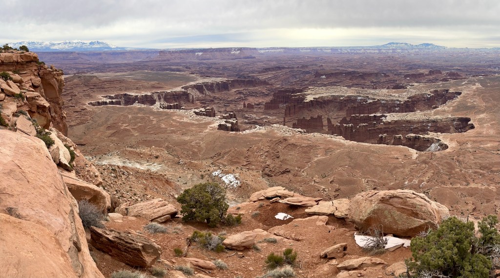
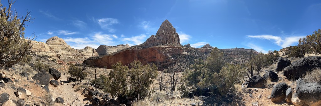
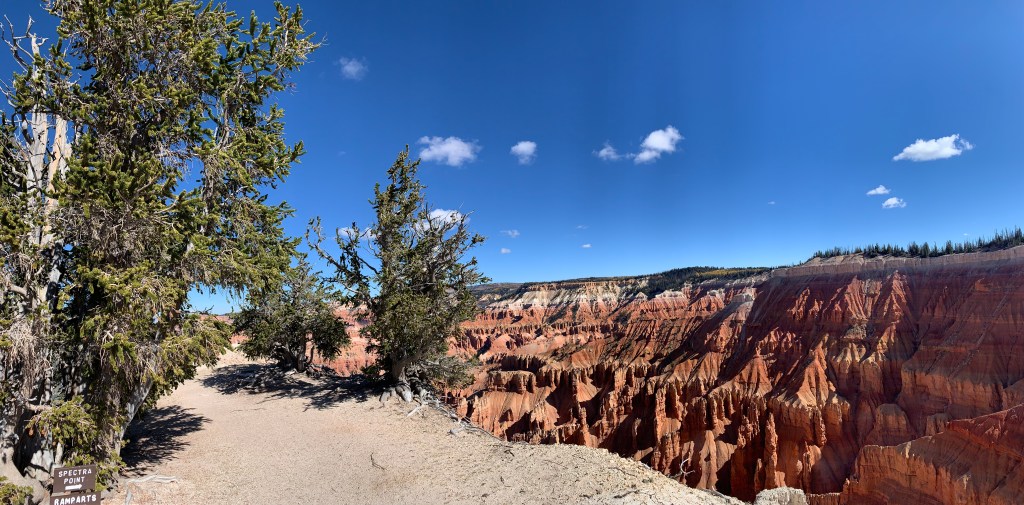
The Mormon Pioneer National Heritage Area includes Bryce, Canyonlands, Capitol Reef, Cedar Breaks and Zion. But besides those geologic wonders, the idea is to encourage more travel on routes 89, 12 and 24. There’s a Scandinavian community around Ephraim in the pretty Sevier Valley on 89. There’s Grand Staircase-Escalante, Goblin Valley, outlaw hideouts, ghost towns, old theaters, and more. I’ve traveled through the NHA in every season taking different routes, and I don’t remember any ugly or boring scenery. Utah is an extremely beautiful state. I occasionally wish it were easier to get something stronger to drink, get a table at a decent restaurant for dinner, or find out more about the Native Americans who used to live there, but it’s unquestionably easy on the eyes.
The Plaza Santo Domingo in the historic center of Mexico City is the southern terminus of ‘The Royal Road of the Interior Land’, a World Heritage Site. As you can see above, some vendors still use traditional market stands on this trade trail first developed by pre-Columbian empires. The whole trail was originally a native trading route for turquoise, obsidian and feathers, and after the Spanish conquest, it was used for military, religious expansion and for silver. From this plaza, the road runs north through San Miguel de Allende and Guanajuato all the way through El Paso (‘the pass’) to Santa Fe (‘holy faith’). The US section—with the same Spanish name—is a national historic trail.
In the background is the Palace of the Inquisition, which arrived from Spain to punish the son of Hernán Cortés, Martín, who threatened independence in 1566. Public burnings of witches and heretics were common for ~250 years, until Mexican Independence ended the practice in 1820. The ‘palace’ now houses a UNAM medical museum, although there is a small gory museum of the inquisition a few blocks away. Mexico City is the largest and oldest city in North America, and it is well worth visiting to be able to walk in the footsteps of history.
In the US, the Independence War means the same as the Revolutionary War, but in Mexico, they are two different wars. 100 years after Hidalgo cried out for Independence from Spain in 1810, the country was under the control of the dictator Porfirio Díaz, who ruled for 35 years over a growing gap between the elites and the masses. He commissioned the ostentatious building above to celebrate his rule, but it ended up celebrating the end of his rule after the Revolution of 1910-1920. Since the common people were uneducated, the new era of called for artists to paint huge public murals to tell the story of Mexico. The three great muralists were Diego Rivera, David Alfaro Siqueiros and Jose Clemente Orozco. All three have murals on permanent exhibit on the oversized second floor inside. Siqueiros uses stunning, clear images to depict the drama of human suffering and bondage. Orozco contrasts vivid lives with cold modern weapons. And Diego Rivera presents his profound understanding of social struggle, using historic figures, ancient images and modern allegories, to awaken people.
The historic center includes far more than one museum, but to appreciate it, you need to understand what’s buried beneath the metropolitan cathedral, grand government buildings and the huge public square. Once there was a lake ringed by volcanoes, and the Aztecs built an empire around an island, using landfill and bridges to create a moated city. Thousands of captured warriors were sacrificed publicly and walls of skulls have been uncovered. From this easily defended base, rich with food grown on floating gardens such as at Xochimilco, over 200,000 lived here, with a sophisticated canal system and extensive trading network. When Hernán Cortés arrived here in 1519, it was one of the largest cities in the world. After building boats and bringing in cannon, the besieged city fell, and the Spanish drained the lake, tore down the temples to make a cathedral, and paved the ruins of the temples and markets to make the huge, empty square Zócalo public space, where over 100,000 now gather to hear the President speak from the balcony of the National Palace or to listen to pop music stars perform. Begin in the Zócalo and take the walking tour to learn about the excavated Aztec ruins and much more in this fascinating, important and historic city center.
South Park City, an old western summertime tourist trap in Fairplay Colorado, is only an hour and a half drive southwest from Denver, and yes, the cartoon is based on this tiny town surrounded by mountains. The mining and ranching town is at ~10,000 feet, and there’s an old railway roundhouse nearby. Some of the ranches organize riding tours, and there are plenty of scenic mountains, canyons, creeks and old mining sites to explore. The trout fishing is renowned. The South Park National Heritage Area is building a good track record of saving old buildings, protecting natural areas and boosting tourism.
About an hour drive north of Denver in Fort Collins is the Cache la Poudre River (French for Gunpowder Stash). Below is the Poudre River Whitewater Park, perhaps the best example of a how planning can turn an urban river into a recreational star. Due to a long-term cooperative water district that balances various stakeholder interests, the river is surprisingly well managed. The wild and scenic section up in the mountains preserves nature, protects wildlife and is enjoyed by whitewater rafters and kayakers. But I saw a kayaker preparing to raft the short stretch of whitewater in town, after changing out of work clothes. The Cache la Poudre River National Heritage Area also includes museums, historic sites and open natural areas in and around Fort Collins.