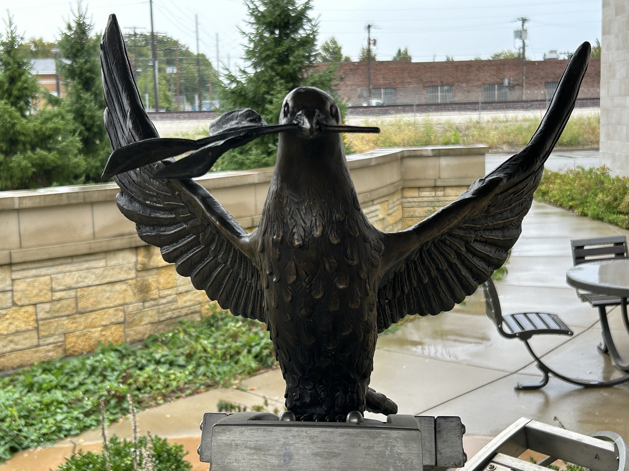
This new park established by President Biden this August is still a fenced off construction area next to the railroad tracks, but there are several art installations dedicated to the riot, including the dove above and a mural at the Children’s Hospital next door. 11th Avenue along the site is known as Reconciliation Way, to commemorate the terrible events here in 1908.
In mid August 1908, in Springfield Illinois, a white mob of five thousand lynched 2 black men, killed 7 others, burned out millions of dollars worth of black homes and businesses and also targeted Jews and whites deemed sympathetic to the black community. The police did nothing to stop the riot. The burning, looting, ransacking and violence lasted 3 days until put down by the state militia, which resulted in 6 dead rioters.
Church leaders blamed the victims for being “sinful”. Although everyone knew the perpetrators and many were arrested, only one 15 year old was convicted after he confessed to stealing revolvers, shooting at black people and starting 15 fires. The others denied any responsibility, the witnesses denied seeing them, and the charges were dismissed. The judge denied that there was racism in Springfield.
Many Americans were shocked by the scale of the violence in Abraham Lincoln’s home town, and civil rights advocates like W.E.B. Du Bois and Ida B. Wells helped form the NAACP in 1909 in response. In 1910 speaking before the NYC Republican Club (the party of Lincoln), Du Bois argued that if racial hierarchy were the natural order of the world, then there would be no need to use social and physical weapons to oppress a race.
“So soon as the prejudiced are forced into this inevitable dilemma, then the real bitterness and indefensibility of their attitude is revealed; they say bluntly that they don’t care what [slurs] may be capable of—they do not like them and they propose to keep such folk in a place of permanent inferiority to the white race—by peaceful policy if possible, but brute force if necessary. And when a group, a nation or a world assumes this attitude, it is handling dynamite. There is in this world no force as the force of a man determined to rise. The human soul cannot be permanently chained.”
Before there was a United States, the Spanish were here first. Over five centuries ago, Spanish explorer Ponce de León arrived in Florida, somewhere near St Augustine. That settlement is older than Plimoth and even older than Jamestowne. Hernando de Soto landed in 1539—at the mouth of Tampa Bay near where Hurricane Milton just landed—, and he led his expedition through what would later become 8 US states. Before the celebration of Hispanic Heritage Month ends on October 15th, we should take a moment to reflect on the deep Hispanic roots of America, reflected in the Spanish names of many of our city, county and state names.
Arizona is ‘Arid Zone’
California is named after a 16th century Spanish fictional island
Colorado was named for it’s rich colors
Florida is ‘Flowery’ since de Leon arrived on Easter, 1513
Montana is ‘Mountainous’
Nevada means ‘Snowy’ in Spanish
New Mexico was part of the Spanish Empire’s reach to Alaska and the Great Lakes
Oregon was first recorded in Spanish
Texas comes from Tejas for ‘Friend’, used to describe Native American allies
And Utah derived from how the Spanish referred to the natives there
The Spanish began European exploration of our country, beginning by funding Columbus. One reason there are Spanish place names throughout the US is due to explorers like De Soto, Coronado, and Cabrillo. How many Americans know that St Augustine is our oldest permanent European settlement? We love Historic Route 66, but do we recognize that such Old Spanish Trails were mapped by Spanish colonizers like de Anza and de Oñate? At El Morro, early settlers carved messages in the rock in Spanish. Spanish speaking traders were at the ancient Casa Grande and at the still open Hubbell Trading Post. 100 years before we gained our Independence from the British, the Pueblo Revolt kicked the Spanish out of what’s now the US southwest. We know that Jefferson bought Louisiana Territory from Napoleon in 1803, but do we know that Napoleon got it from Spain in 1800? Our Midwest roots are both French and Spanish. The Presidio in San Francisco was Mexican for decades before the US Army took over.
And yet for some reason, we persist in ignoring our Hispanic Heritage. The Canadian River flows from Colorado, through New Mexico, Texas and Oklahoma, and it was mapped by Governor Oñate in 1601. The river’s most remarkable geographic feature is in Texas, where it runs through Palo Duro Canyon, the second largest canyon in the US, described as a cañada in Spanish. And yet for generations, English speakers have tried finding non-Spanish explanations for the river’s name, such as lies that the French trappers didn’t know any Spanish, didn’t trade with the Spanish there and confusedly thought that the river came from Canada. Ridiculous!
While the ignorant falsely view Spanish speakers as only recent immigrants, in much of the country the Spanish speakers were here first, remaining for generations, even as wars and borders changed their lands from Spain or Mexico to the US. Over 40 million Americans speak Spanish at home, as they have for generations. Spanish speakers and their descendants should be rightfully recognized as founding members of our country, as their experiences and lives here predate English speaking settlers, and Spanish speaking citizens have continued contributing to our country, despite prejudice against them.
Unlike the war-shrine Alamo, the San Antonio, Tumacacori and other missions today are dedicated to peace and understanding. Despite some politicians trying to divide us, the Mexican border has long been peaceful, with disputes negotiated at places like Chamizal above in El Paso. César Chávez organized the first permanent agricultural union in the US, to lift up the lives of millions of people. And when Brown v Board of Education ended segregated schools for African Americans, it also ended segregation for Spanish speaking students at places like Blackwell School in Texas.
We should learn about our Hispanic Heritage and our past discrimination—including tragedies of mob violence and mass deportations—, so that we reject hatred and division. We can be a more just, inclusive and a better society.
“Those who cannot remember the past are condemned to repeat it.”
Traditional historians have generally argued that the War of 1812 was about defending US maritime rights, especially of US citizens who were involuntarily ‘impressed’ into the British Navy. Jefferson had certainly left some trade issues with Britain, but such disputes rarely go to war. During the war, the northeastern states continued trading with Britain, and the treaty at the end of the war did not change the maritime rights status quo legally. Americans worked harder at getting compensation for slave owners whose slaves were freed by the British than for US citizens impressed into the British Navy. So that whole explanation for the war is obviously wrong.
More enlightened historians have argued that the War of 1812 was about expanding US territory at a time when the British were busy fighting Napoleon, as stated by the dominant party in Congress and President Madison, who called acquiring Canada “a collateral benefit”. During the war the US invaded Canada 10 times, took land in the southeast including in Alabama, Florida, Georgia, Louisiana and Mississippi, and took land in the then northwest including Indiana, Illinois, Michigan, Ohio and Wisconsin. Most of the US territorial expansion around the time of the war was from Native American lands, regardless of whether they fought for the British or the Americans. So that whole ‘expansion’ explanation checks out.
If we think about the war at all, most Americans view the War of 1812-1815 as about nationalism, patriotism and rallying around our flag, perhaps because we did not achieve any of our objectives, failed to take Canada and had our national capital burned. Canadians tend to view the war more as a heroic defense against our ill-conceived and unpopular aggression, as after all, the Americans burned York—their capital of ‘Upper Canada’ in Ontario province—first. The truth is always more complicated, as you can see comparing the capital burnings. After the British general retreated from York, local militia started fires to prevent the Americans from seizing their supplies, and the resulting gunpowder magazine explosion killed the American general along with ~200 other casualties. The American troops, not under official orders, burned public buildings and businesses. When the British seized Washington DC, they burned most public buildings, including the White House, under orders. Which gives you a sense of the animosity at the time.
Fort McHenry, Fort Washington and the Star Spangled Banner trail focus on the dramatic events around DC and Baltimore, but there are other US park sites that tell more of the story. Along with failing to continue Washington’s peaceful tactics and trade agreements with Britain, the expansionist Jefferson hired Albert Gallatin to reduce the national debt, and Gallatin cut the military budget, leaving successor Madison the contradictory problems of war and a weak military. The US could not match the British Navy in the Atlantic, except for the USS Constitution: Old Ironsides. So the British blockaded the US ships along the eastern seaboard, except for smugglers in New England. So, technically port forts like Monroe and those guarding Mobile Bay had roles in this war, but their primary historical importance is based on events of other times.
The old Northwest Territories around the Great Lakes were long contested by the Americans, British, Native Americans, French and Spanish. River Raisin, near Detroit, is a good place to learn how we provoked the War of 1812 to take native lands. The Americans had two great naval victories during the war, first in 1813 on Lake Erie, where Perry broke the British inland fleet and cut off their supply lines to their western forts, and second in 1814 on Lake Champlain, where Macdonough thwarted a British invasion via the Hudson. The Americans made several incursions into Canada, but were unable to hold territory north of the Great Lakes and even lost their poorly manned Old Fort Niagara in New York, returned by treaty. The war encouraged the French and British in Canada to join together for common defense, eventually forming Canada in 1867. The military stalemate clearly defined the eastern border between Canada and the US, contributing to our long peaceful history since.
In the American southeast, the more consequential war was the simultaneous Creek War and related actions. At Horseshoe Bend Andrew Jackson used Cherokee and Creek allies to defeat other Creeks, even as his allies took lands from both sides. When Napoleon abdicated, the British no longer needed to kidnap American sailors to fill their fleet, and they were able to turn their full attention to their former colony. The American diplomats, led by John Q. Adams along with Gallatin and others, wisely negotiated a peace treaty. But before the news arrived stateside, Andrew Jackson took New Orleans, with the help of the French pirate Jean Lafitte in a story told here. Jackson leveraged his victory to win the White House and used office to enforce the Trail of Tears. He also invaded Florida in 1818, convincing the Spanish to sell the territory to us in 1819. While the Native Americans lost the most in the lead up, during the war and in its aftermath, many African Americans took the opportunity to escape to Canada along the Underground Railroad.
Often overshadowed by the Revolution and the Civil War, the War of 1812 offers many lessons of popular patriotism driving greedy expansionism, reckless militarism and brutally unfair racist policies, with costly, unforeseen consequences. Rather than simply look at flags or teach our kids one heroic story, we should think critically about history so we can make better decisions in the future.
There are five affiliated sites in the North Atlantic region: Kate Mullany NHS, Lower East Side Tenement NHS, Roosevelt Campobello IP, Thomas Cole NHS and Touro Synagogue NHS. Campobello (above) is actually in New Brunswick Canada, just across the Maine border. Touro is in Newport Rhode Island. And the others are in the Empire State.
All five are among my favorite sites in the country.
The congregation at Touro predates our country, and they have the promise of religious equality made by George Washington in writing.
Take the tour, sit in the pews, and listen to the stories of freedom to believe.
In the early 1800s, Cole painted romantic landscapes and historical scenes, inspiring a school of painters.
Tour his house and studio, see the exhibits and listen to the stories behind his work.
From the late 1800s to early 1900s, the garment district immigrants toiled in sweaty tenement buildings and built futures in their new country.
Go to a neighborhood deli, tour the tiny rooms, and listen to the stories of strikes and hope.
FDR’s summer home in Canada immaculately preserves over 100 years of precious memories.
Tour the estate, have a cookie at Eleanor’s tea, and listen to the stories of recovery and advocacy.
The newly open Mullany house tells the little known story of the woman who started the first official female union in the country.
Make a reservation for a tour, see the history of American labor on the walls, and listen to the stories of the workers who built our country.
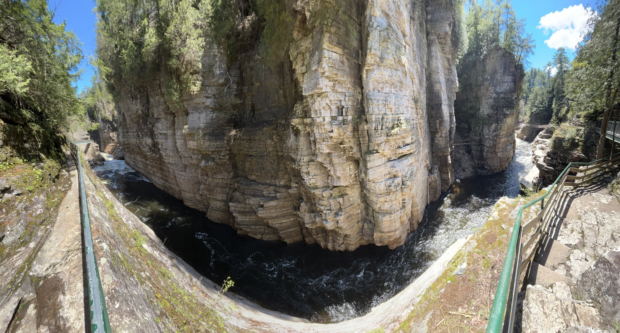
Much of upstate New York belongs to the Adirondacks, with old mountains, lakes, forests, wildlife and scenery. Two of the more famous tourist spots are the High Falls Gorge (above) and the Ausable Chasm (below), both on the Ausable River—from the French ‘au sable’ meaning ‘sandy’—which is fed from Lake Placid and flows down to Lake Champlain. Since they’re well developed old trails, walking along the secure walkways and overlooks costs about $20 each, but I think they’re still worth it, though neither is quite the scale I imagined for the ‘Grand Canyon of the East’.
Lake Champlain is part of the water route from New York City to Quebec, so several key battles were fought in the area, including at Saratoga and during the War of 1812. The British were winning in 1814, having sacked DC, but Thomas Macdonough won the Battle of Lake Champlain aboard his ship, the USS Saratoga, thwarting a British invasion down the Hudson in 1814.
This National Heritage Area preserves both history and beautiful nature, including Marsh-Billings-Rockefeller in Vermont. The Champlain-Adirondack Biosphere is also recognized by UNESCO for its forests, wetlands and mountains in both upstate NY and about 1/2 of Vermont. Unfortunately, the Trump administration ended the only other UNESCO Biosphere in the North Atlantic Region at New Hampshire’s Hubbard Brook hardwood forest research. Still, there are many other fascinating places to visit in this diverse heritage area, such as the Antique Boat Museum in Clayton New York on the St Lawrence River, as well as the scenic homelands of the Algonquin and Iroquois people near the Canadian border.
The Midwest region has 8 NHA’s—more than most regions—ranging from industrial to pastoral, and most are devoted to travel by horse, boat, car or plane. Each heritage area provides a unique way for us to learn our history and explore our diverse culture in vibrant and interactive ways, such as riding in a Santa Fe Trail stagecoach above. Parks travelers tend to focus on the most famous iconic national parks, but I found some of my most treasured experiences below.
Abraham Lincoln covers his working life, campaign and legacy in Illinois.
Bronzeville celebrates the rich culture of the south side of Chicago.
If you missed any of the posts above, I encourage you to click on them now, especially the last one. I’m slowly filling in the map and will continue posting Midwest state photo summaries on alternate Saturdays. I only have a few more Midwest national park units to post before I complete all sites in the region, and look for a few more New York sites. Thursdays will alternate between summaries like this one and eclectic extras like last week.
Recently I returned with my kids and my Mom (above right) to Duxbury in Massachusetts, where she grew up. Duxbury is a pretty seaside town with a large harbor on the north end of Plymouth Bay, reflecting the long history of our seafaring roots. When the Pilgrims arrived on the Mayflower in 1620, they first landed in Provincetown on the tip of Cape Cod, skirmished with the natives and then moved to Plymouth. The military commander, Miles Standish, settled in Duxbury, and his statue stands there atop a large viewing tower on Captain’s Hill. Longfellow wrote a romantic poem about a love triangle between Standish, the cooper John Alden and a recently orphaned teen named Priscilla Mullins. John and Priscilla Alden lived on the homestead above, which is still owned by their many descendants as a National Historic Landmark.
The Aldens were Pilgrims, not Puritans. The Pilgrims had separated from the Church of England, while the Puritans did not. Just before arriving in Plymouth to form a new colony, while awaiting royal permission, the Pilgrims and others aboard wrote an independent contract, the Mayflower Compact of 1620, which was the first self-governing document by British settlers in the now USA, although the British colony of Jamestowne was founded first. The Puritans arrived around 1630, settling in Boston and Salem. Contrary to the ‘mind your own business’ ethos of the Pilgrims, the Puritans were so strict that many left their colony for religious freedom. Such historic differences may seem inconsequential now, but freedom versus loyalty to England would become a big issue in Concord in 1775. And still today, there are conflicts between those who would impose their strict religious beliefs and those who prefer more freedom to make our own choices.
Driving back over the bridge from the beach, we got a glimpse of Miles Standish looking out over the harbor once famed for ship building and a large merchant fleet, before we went to dinner at a haunted restaurant, built before the Revolution. Moments like these improve our perspective, remembering the breathtaking leap of faith our ancestors took to settle here. While not part of the NPS, I recommend visiting the reconstructed living history museum in Plymouth, now called Plimoth Patuxet Museums, as well as other historic sites in the area like Alden House in Duxbury where we enjoyed an excellent tour.
Abraham Lincoln is remembered in the name of four national park sites and one national heritage area, and he is an integral part of at least four more sites, not to mention numerous other national and state sites, landmarks, parks and much more.
Abraham Lincoln National Heritage Area is in Illinois, and it includes hundreds of waysides, visitors centers, historic sites, debate sites, Lincoln’s impressive tomb in Springfield, tour routes, museums and more. The Lincoln Home and the nearby Presidential Library & Museum are key partners with the non-profit that preserves his legacy and cooperates with towns and others who celebrate Lincoln and promote Lincoln tourism.
The NPS recognizes the following four sites as integral to understanding his legacy, but many of the Civil War sites and more are part of the full story, particularly Gettysburg and Appomattox. There’s even a Lincoln story (photo above) in the defense of Washington DC.
I recently completed EV visits to all five NPS affiliated sites in the Midwest, which were interesting and educational. Wisconsin is a good place to learn about drumlin hills, kettle lakes and moraine at the various park interpretive centers in the Ice Age National Scientific Reserve. The story of Father Marquette’s voyages and the Chicago Portage stretches through several states. Toledo Ohio keeps history at the Fallen Timbers Battlefield and Fort Miamis (see the fort’s footprint above) on the banks of the Maumee River. And Nebraska protects Chimney Rock on the pioneer trails.
Much more coming soon, including three national parks, biospheres, and heritage areas as I wrap up the Midwest region. And I reveal my secret project. Stay tuned!
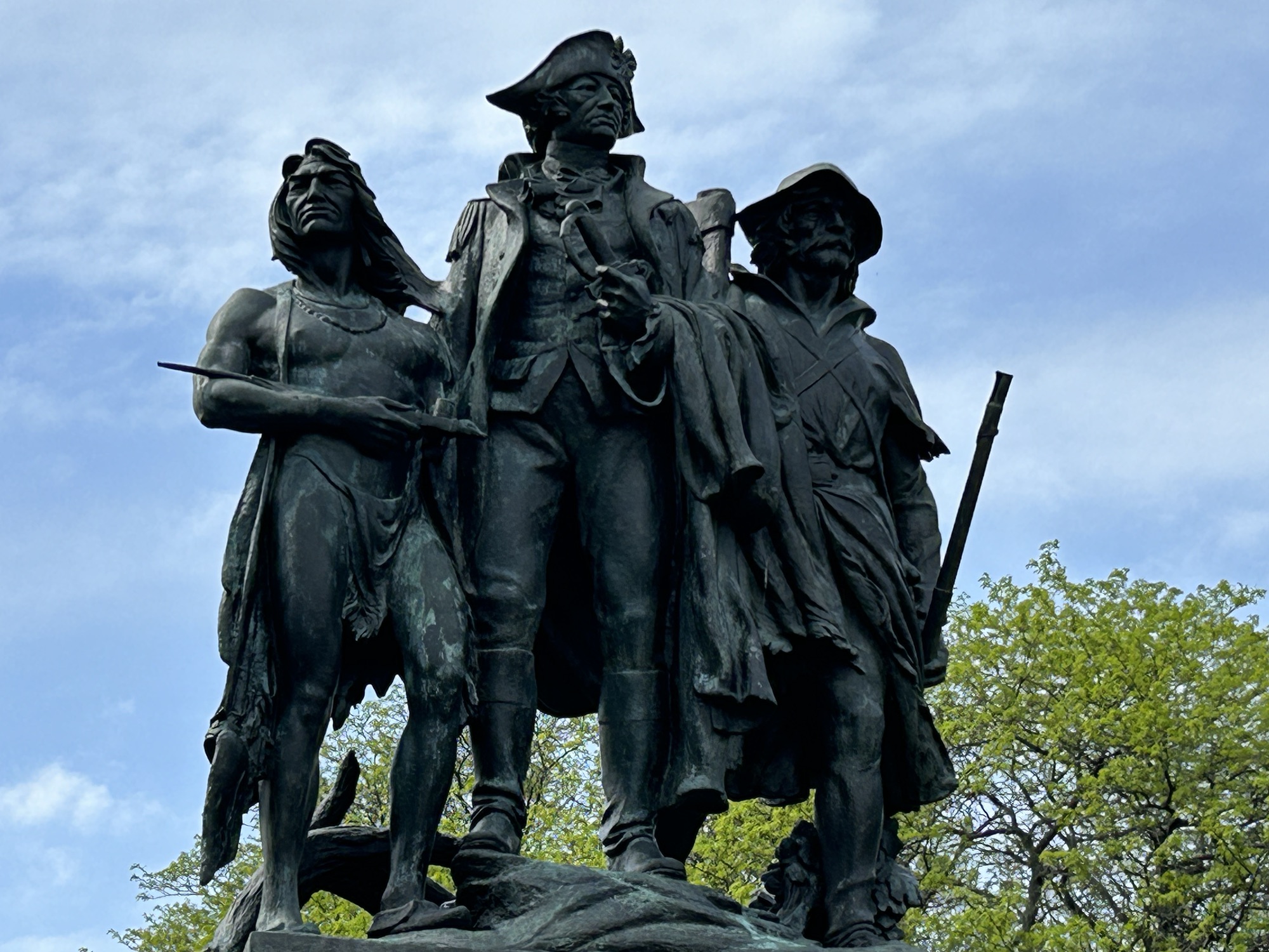
The much disputed western frontier was once here in Ohio, where the British Fort Miamis guarded the crossing point and last navigable stretch of the Maumee River to Lake Erie, backed by their confederation of Native American allies. George Washington sent General Wayne (above center) here after his previous general had been defeated. In 1794, Wayne’s troops met over 1,000 native warriors in battle, and prevailed, resulting in much native land being ceded to the US.
In 1811, Indiana Governor William Henry Harrison provoked the natives into fighting again. When the War of 1812 broke out, the British reforged their native alliances and used their naval power to reoccupy Fort Miamis. Now General Harrison—later the 9th President—built a new fort on the other side of the Maumee River and held it against attack. The fighting then moved north, where Harrison’s troops killed the Shawnee leader Tecumseh and defeated the British on the Canadian side of Lake Erie, ending both the British occupation and native land ownership in most of the northwest.
The site is affiliated with the NPS and managed by Toledo. Due to an early mistaken account of where the battle occurred, the statue above is neither on nor facing the battlefield, which is behind them over a bike bridge in the woods. There are plenty of bike trails connecting different riverside parks, and there’s an Audubon island with heron in the middle of the river. The earthworks of Fort Miamis are still clearly visible overlooking the Maumee. History and nature await us.