What a beautiful place! A Canadian horticulturalist, Dr Henry Moore, deserves credit for the idea creating a peace garden—built during the Great Depression—on the Manitoba / North Dakota border. America has far more war memorials than parks devoted to peace. Chamizal on the Mexican border is dedicated to diplomacy, and Perry’s is both a war and peace memorial. As we begin a new year, we should not take peace and diplomacy for granted, given all we sacrificed in wars.
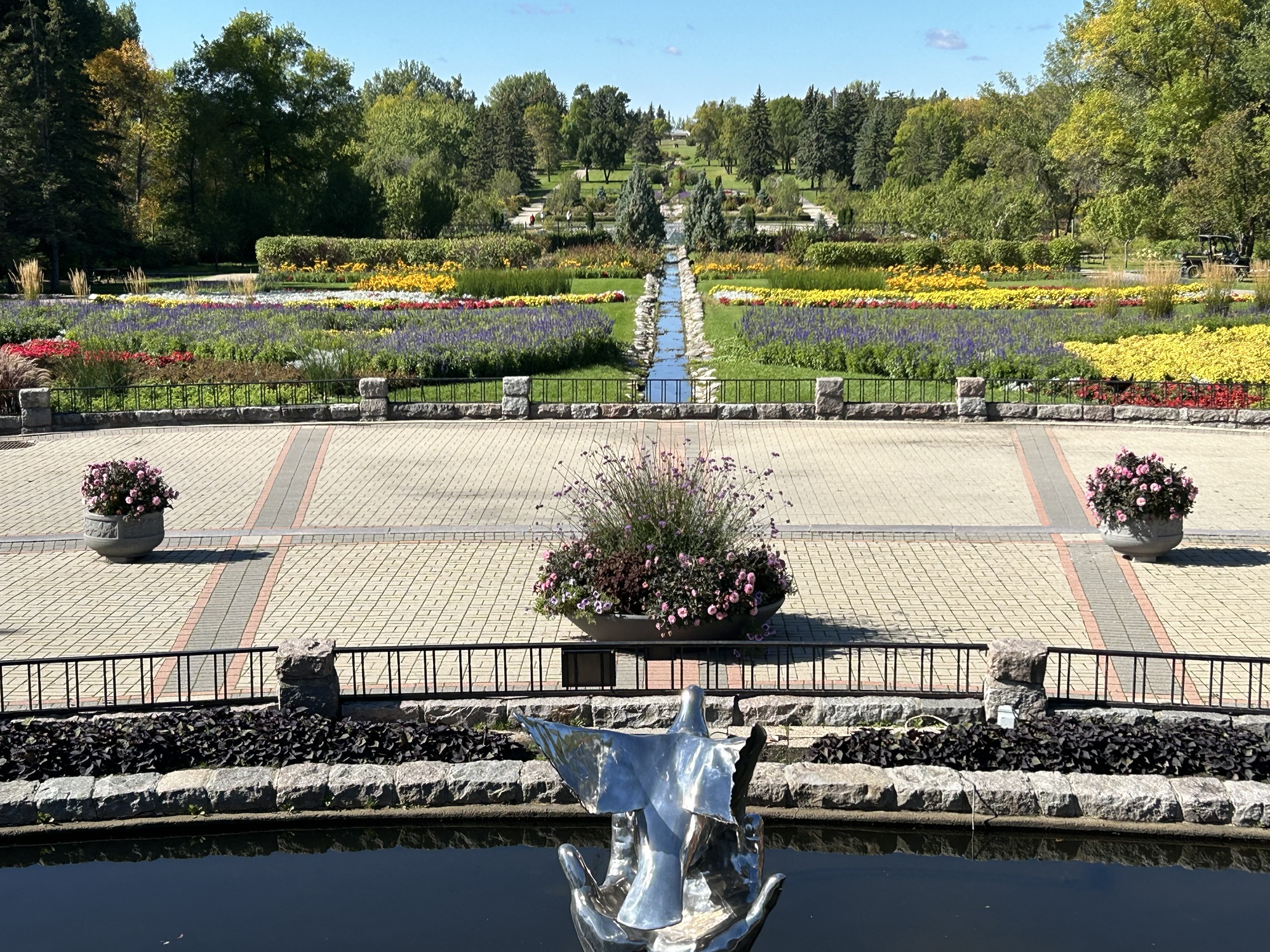
This affiliated park, a favorite of mine, is a neutral zone with the entrance between each country’s border security. You will need proper id either to continue on or to return to your home country after your visit here. The park is not far from the small town of Rugby North Dakota, which is the geographic center of North America. It’s a bit of a trek from the nearest US supercharger in Grand Forks, but there are a couple car dealers on the way that offer CCS charging if you have the adapter. Also, the park itself has a free electric 1772 car charger at the drop off entrance to the Conservatory, which has a massive collection of succulents donated by local enthusiasts.
Technically I missed the peak season, but as you can see above, there were plenty of flowers still in bloom at the end of September. There’s a long winding drive through the woods with lakeside picnic grounds below, a campground and a few cabins and more around the central border gardens. And if you walk the length of the formal garden above, the building at the end is the Peace Chapel, which is the perfect place to find inspiration and hope for peace in the quotes from famous leaders and philosophers carved inside its walls.
Welcome to Mexico! Above is the statue of Miguel Hidalgo y Castilla, the parish priest who on 16 September 1810 cried for independence—Grito de Dolores—in front of his church in Dolores (now Dolores Hidalgo in Guanajuato) sparking Mexican Independence. Mondays for now are World Heritage Sites, while eclectic Thursdays still include US park posts.
How to Drive Across the Border from US to Mexico
This post will cover my border crossing experience, including getting a permit for my car, and I hope it helps others who may be planning a similar trip.
I crossed the border at Puente Anzalduas, near McAllen Texas. I chose this place for several reasons. McAllen is a nice city with all the conveniences. There’s a supercharger in McAllen and another one 85 miles away in Mexico. This border crossing has everything I need to legally drive my car in Mexico, all in one room, with plenty of parking, and it isn’t too crowded. The bridge allows an easy trip around the city of Reynosa, and quickly puts me on the toll highway directly to my route to Mexico City. Even though I drove from California, it’s faster to drive through Texas on the freeway at 80 mph than to drive tollways in Mexico, especially as the supercharger network isn’t nationwide in Mexico yet. I recommend this crossing if you’re planning on driving to Mexico City, especially in a Tesla!
I found a lot of wrong information (see below) about driving across the border, which caused me delays and frustration. If you’re just driving in Baja California or to Rocky Point or just along the border inside Mexico, you don’t need any paperwork. But if you want to drive elsewhere, then here’s the real story: first, my recent experience, and then, all my failures. Read and learn!
I crossed the border at around 9:30 am last Tuesday (27 February 2024), and there was virtually no wait. US Border Patrol checked my car, and then I drove across the bridge with a $3.50 toll. On the Mexico side of the border, take the left lane, since you need to declare your vehicle. If you miss the turn (like me), stay left and turn sharp left to go behind the buildings. Either way you end up in the same place, the Aduana, or Customs office. There’s a line of cars here that arrived from the other direction who are waiting to return their permits at the kiosk. Ignore them, park, and walk around to find the front door.
Customs is there to collect taxes on goods you import, including your car. But, since you’re just using your car temporarily during your visit before leaving with it, you don’t have to pay taxes. Customs checked my vehicle, including taking a photo of the VIN, and then they checked that I was the registered owner. California’s registration card includes my name, address, VIN and plate, and I had both my current card and my new one effective next week. Satisfied, they told me to walk across the room to Immigration.
Immigration is there to admit you into the country. These days, Americans like me can visit Mexico for up to 180 days without paperwork. But, since I need a permit for my car, they make an exception, give me an entry card to fill out, and they issue the 180 day form (FMM) for 717 pesos ($42) on my credit card. Satisfied, I walk back across the room to the copy desk, where they charge me $1 for a copy of my passport, my new FMM, and my registration cards. The copies are for the final step, the Banjercito.
The Banjercitois the government bank that issues the official vehicle permit that you must show at highway checkpoints. Here, they’re in the same room, right between Customs and Immigration desks, so they’ve already seen me walking back and forth. The permit proves that your identity, vehicle ownership and temporary status in the country have already been thoroughly checked by the right authorities, and the permit (TIP) contains all the relevant information. After signing several forms and providing my contact details, they took $468.30 (8,000 pesos) on my credit card, but supposedly I get almost all of that back when I return the permit. (When you leave Mexico, hand over the permit at the Banjercito kiosk and either cancel for a refund or tell them you intend to reuse it before it expires).
Satisfied, I drove deep into Mexico. I was stopped by the National Guard highway patrol twice on my first day, and all they want to see is this permit before quickly sending me on my way. I hope this all seems logical to you and clears up some common confusion, especially for first time drivers to Mexico. Plenty of folks do this every day, so you can too. But you might want to learn from my mistakes.
What Not To Do
Don’t cross from California or western Arizona if you’re driving throughout Mexico. From the Baja Peninsula to Puerto Peñasco and the Lukeville Arizona crossing, Americans enjoy a document free zone, so don’t expect the Mexican officials to issue documentation for elsewhere in Mexico, after they eliminated all the documents. If you really want to take the ferry from La Paz, then why not do that on the way back? It’s theoretically possible to get the paperwork to drive from Baja to the rest of Mexico, but in practice, I found it didn’t work this year.
Don’t park on the US side and walk across to get documents for your vehicle. They want to see your vehicle and check the VIN. Again, it may be possible, but you’re depending on officials giving you a break, which you may or may not deserve. At San Ysidro California, I walked across the border a couple weeks ago to ask for documents, but they didn’t have anyone there during working hours midweek that could issue the paperwork. I spent over an hour in line in Tijuana waiting to walk back.
Don’t cross at some remote location or in the middle of a busy city, especially if it’s your first time. I crossed last year at a tiny place west of El Paso, but the Banjercito was closed (again, midday, midweek). Juarez, across the border from El Paso, is a big city, and I found it difficult to drive around and park, before walking the streets looking for various government offices that I knew little about. Laredo Texas is across from Nuevo Laredo, which is also a busy city crossing. The bridges each have different traffic rules and allow different vehicles, and there are precious few parking spaces at Customs, if you’re lucky enough to be in the correct lane. Otherwise you’re driving and walking around in a strange city. You want to find a border crossing that handles everything in one place, with parking, without too much traffic, and without city traffic driving.
Don’t go to a Mexican Consulate in the US. I went to San Bernardino, and they looked at me like I was an alien. They only handle paperwork like that for an hour a day after lunch on certain days of the week and only for residents of the county and not for neighboring counties and they only give paperwork for students and others who need long term temporary residency and they need bank statements and photos and two dozen other documents. Didn’t I know that I don’t need paperwork to visit Mexico normally? I know there’s a web page that claims you can make an appointment at various consulates, but it doesn’t work.
Don’t try to get your documents online. I hired a company to get my documents, and I had to demand my money back when they couldn’t deliver. Then I tried to use official websites. I got far enough to create accounts at two agencies, upload documents, pay a fee and choose my crossing date and place, but then I didn’t receive anything. And when I tried contacting them through the email and websites, I got an automated response saying “sorry, we can’t help you.” I’m never getting that fee refunded.
Even if you can get your documents online, at some point maybe two months in advance, what if you are delayed by a day or the crossing that you picked is closed (as happened twice to me)? And when you get there, you still need to get your VIN & registration checked by customs, you still need your FMM checked and stamped, you still need to make a copy of your stamped FMM, and you still need to show everything to the Banjercito, who will still want to see the original documents too. The folks next to me had done everything online, and I had done nothing. But I finished faster, because they had someone with them who translated everything. I just pointed, used simple English, and handed over my credit card.
Don’t make three copies of everything. I needed one black and white copy of my passport, one of my registration, and one of my FMM. I didn’t need three copies of anything. Nobody looked at my Mexican car insurance. Nobody looked at my car title. I wasted several trips to the UPS store and Office Depot making copies of documents that I never used. There’s no way to avoid making a copy of your FMM at the border, so you might as well just wait until they tell you what copies they need.
Plan your route and pick a good crossing point, but don’t drive yourself crazy. Culture shock, anxiety, official warnings and anti-Mexican horror stories made me overthink everything. I read that Columbia Bridge near Laredo was a great place to cross, since it’s one of the few places where you enter into Nuevo León. But when I checked the map, I would still have to drive back through Tamaulipas on a much longer route. Eventually I picked the shorter straight route above. Take your time, travel by daylight, watch for speed-bumps, and be patient. Oh, and have fun!
[Note: Starting today, I’m switching to Monday, Wednesday & Friday posts to keep more up to date.]
The strange elk in the background are actually Nilgai, an Asian Antelope that escaped from a ranching project and now live in the park. In a way, it’s appropriate to start with an invasive species, since this park marks the start of the Mexican American War. In the 1840’s President Polk campaigned on expanding the country westward and as President sent troops to the Rio Grande, even though Mexico viewed it as their territory. Mexico, having only recently won its independence in 1821, was having trouble managing its northernmost territories, and lost control of much of Texas during a revolt by American settlers in the 1830’s. When Mexico’s army crossed the Rio Grande to expel the interlopers, Polk claimed that America was under attack and the war was on.
Mexico laid siege to a small fort on the north bank of the Rio Grande, and US troops were rushed in from up the coast to reinforce it. The two forces met in the middle here in a dry part of the delta. The US had better artillery, and the Mexicans had more men. The US troops were under command of Zachary Taylor, who later turned his war fame into a successful run for President, and many veterans of this battle would go on to serve in the Civil War. Lt. US Grant, who opposed war with Mexico personally, engaged in his first battle here. Between heavier guns firing more deadly shells, light guns quickly turned to face flanking attacks, and well trained US troops who engaged in hand to hand combat between here and the fort, the Mexican Army was forced to retreat. Around 100 Mexican troops and 10 US troops died in battle here.
Today the field is marked with flags and cannon to show the positions of the two sides and ‘interpretive exhibits’—small signs—to explain what happened in different places where the troops faced off. Closer to Brownsville, there’s a much smaller battlefield, the Resaca de la Palma, where the Mexican Army bravely made a stand to protect their retreat. There is a viewing platform of the resaca, meaning ‘often dry river delta channel’ (and not ‘hangover’, as the word means today). The siege of the fort was lifted, but the fort’s leader Major Brown and one other US soldier were killed in action. The fort and eventual city, Brownsville, were later named for the young officer.
Although the site only covers the first week of the war that took place in what’s now the US, the war raged on for two more years with US troops taking cities deep into Mexico, until Mexico agreed to cede Texas and sell its rights west all the way to the Pacific. Mexico lost 1/2 its territory and the US doubled in size. As interesting and consequential as the history is, the site is a well-marked field with a path for each army, so it requires some imagination and curiosity to appreciate. The small visitor center is educational, bilingual, has an informative film, and has enthusiastic and knowledgeable rangers and volunteers. But by all means go out on the battlefield, if only to see the wildlife. I saw over a dozen Nilgai, several hawks hunting in the tall grasses, a crested caracara, and more. This is a well-known area for birders.
The Rio Pequeño (not grande with this low water) enters the Boquillas Canyon here and continues down to Amistad. Hiking into the canyon along the border, there are few signs of the modern world, and I suddenly felt like I was in a classic western movie when I heard horses approaching. Three horse riders offered handcrafted souvenirs and chicken tamales as they passed, and when one was crossing back to Boquillas Mexico on horseback, his horse had to bend down to knee level to drink from the middle of the river. Hardly worth crossing by rowboat at the port of entry, when folks were wading across the river. (Yeah, yeah rules, but no harm no foul with kids just playing in the water).
The Climate Crisis is playing havoc with my plans. Not sure when I’ll get the kayak wet this trip. A few days ago, I was trudging through the snow in Zion, and here in winter the temperature hit over 100 degrees on the trail. Best to visit in February, and always bring plenty of water. Last year I just carried a water bottle, but now I use a 3L hydration pack with another 5 gallon container in my car. The heat is no joke; a hiker died here just a few days ago, one more of many.
Due to low water and logistics, I’m only exploring the river from the dusty trails and grand overlooks within Big Bend. The US and Mexico protect 200 miles of land alongside the river, including the canyon above, another at Santa Elena and a big reserve on the south bank opposite Big Bend. In particular, there’s a nature trail at Rio Grande Village, where I spotted a half dozen bird species in minutes, including a Great Blue Heron and my first sighting of a Black Phoebe flycatcher. It’s unfortunate that so many communities take most of the river water without considering the downstream impact on birds and other species. I know people pay extra for golf courses, ornamental plants and water features, but national nature reserves suffer directly as a result. Americans need to invest in solar desalination facilities and leave rivers alone.
They’re not exactly sure which river valley Coronado walked up with his plumed helmet, shining cuirass, retinue, soldiers and slaves on his way to find the seven cities of gold, but from the bluff here, you can see both. Apparently, a couple natives convinced him to walk as far as Kansas, before he realized it was a ruse and executed them.
The park is near the Mexican border, and someday there’s hope that there will be a sister park on the other side. Of course these days, some people are paranoid about migrants crossing illegally, so there were plenty of warnings and border patrol operations nearby. I can’t see anybody climbing all the way up here without a vehicle. The road up is unpaved and there’s parking a short hike from where I took the photo. Although the road is rough, it presented a scenic shortcut to my next destination.
Unlike any other park, Chamizal memorializes diplomacy. When the Rio Grande shifted course at the end of the 1800’s, it created an island and a seven decade long border dispute with Mexico. President Kennedy went to Mexico to finalize an agreement, and LBJ later participated in the joint ceremony at the border here. There’s a beautiful mural on the visitor’s center, and I remember from a previous visit that there’s a film that explains the importance inside.