Ignore the famed waterfalls and focus on Goat Island cliff in the middle. That wall is the Niagara Escarpment, caused by relatively hard rocks at the top holding the land underneath together, until it erodes away from the side. This two level land break—all erosion and not earthquake fault—is the key geologic feature to understanding the Great Lakes.
Much of the escarpment is in Canada, and even where it crosses the border to form Niagara Falls, it’s easier to see from the Canadian side as above. It runs along the south shore of Lake Ontario, across Niagara Falls (above) where it sets the level of Lake Erie, northwest through Ontario where it guides the Bruce Trail, up along the north shore of Lake Huron where it splits off Georgian Bay and shapes Lakes Huron and Michigan, along Michigan’s Upper Peninsula where it separates Lake Superior, and down the Door Peninsula past Green Bay in Wisconsin. After driving around the Great Lakes, it’s apparent how the water levels depend on the escarpment: Superior is the highest above both ends, Michigan and Huron are the same level in the middle, and shallow Erie is a little lower, held back at Niagara Falls, before that river drains into the lowest lake, Ontario.
UNESCO defines the Biosphere as the mostly forested area of Ontario between Niagara Falls and Tobermory on the tip of the Bruce Peninsula next to Georgian Bay, roughly 500 miles along the escarpment. The geologically interesting landscape holds great biodiversity in wetlands, coastline, deciduous & conifer forests, and rocky bluffs, perhaps the most in Canada. And there are many opportunities to explore, photograph wildlife, hike, drive or boat nearby. I hiked on the Cup & Saucer Trail on Manitoulin Island, the world’s largest freshwater island, when traveling around the Great Lakes. There, the escarpment is eroded on both sides, providing many views along its edge, including Lake Manitou below.
To visit 16 of Mexico’s World Heritage Sites in a zero emission vehicle, I drove round trip from Texas to Mexico City, through 13 Mexican states, and, while a bit bumpy, I enjoyed the trip very much. All my trip report links are at the end of this post.
If you read online comments in the US, you might get the idea that traveling in Mexico is impossible or foolhardy at best. Well, you can’t believe everything you read online (except this blog of course). Over the entire trip, I was only asked for one ‘bribe’ of $1, to park briefly in a student parking lot without a student id. The state police, national guard and military were all very professional and waved me through either without comment or after glancing at my car permit. While I saw crime on the TV news in Mexico, I observed none.
After driving in Mexico, I finally understand driving in Texas. Instead of overpasses, underpasses and clover leafs, just use ‘retornos’ or U-turns. Folks leave the nice highways, well, they’re on their own, immediately. Want to slow traffic, without relying on folks to obey signs? Just use lots of speed-bumps or topes. Although, there are even more techniques to learn. First, always be alert. Pothole! Second, drive halfway in the breakdown lane to avoid head-on collisions with oncoming passing traffic. Third, always be alert, seriously, you need to pay attention and think while driving. Drivers are generally nice, but get out of the way of speed demons and quickly pass vehicles that wouldn’t be allowed on the roads in the US.
All Mexico is divided into three parts. Mexico City is best navigated by metro, with its one way streets, traffic and lack of parking. Traffic can be stultifying. Of course, electric cars are exempt from the Hoy No Circula—‘no driving today’—restrictions, which otherwise limit your access to the city according to the last character of your license plate. Circumnavigating the city on the ring road requires tolls: take your ticket and be prepared to pay cash (although a few places take credit cards). Remember the metro is 5 pesos or ~30 cents.
The mid-sized cities and tourist areas outside Mexico City are still crowded, but passable by private car. I was frequently fortunate to find parking very near World Heritage Sites in mid-sized city centers. Of course, the more touristy, the more likely that the roads are cobblestone. San Miguel de Allende may be magical, but I scraped the bottom of my car several times on medieval stones. Better to park outside the historic zones and walk. Still, driving your own car gets you to places that are otherwise challenging to reach.
And then there are the mountains and remote villages. Ah, lovely! But no signal to navigate. I got lost three times near the butterfly reserve. Once, my navigation asked me to drive between two trees on each side of a hiking trail. But I must admit, some of the most beautiful places in Mexico are just off the grid. Horse-driven ploughs, indigenous costumes, and forest-covered volcanoes await. Long drives are best on toll roads with frequent $5 to $15 tolls.
On this trip, I used Superchargers exclusively, and I only saw half a dozen Teslas in Mexico, including my own, mostly at chargers. Unlike the US, there isn’t a government subsidy for most electric cars, so my car was not just unusual, but uneconomical in the short run. I got few comments or looks, and the valet parking attendants had never driven one before (and didn’t like them). There are a few other electric models that I saw on TV, which we don’t have in the US, and I spotted a few of those in Mexico. But overall, electric cars are an elite affair, with parking and charging in the most expensive malls in expensive neighborhoods. I found the supercharger network from McAllen to Puebla accessible and without gaps, although it’s better to charge whenever you can, just in case you need a lot of air conditioning or have to detour.
While Mexico might seem intimidating or unrefined, the truth is that it’s worth the trouble. There are European-style cathedrals, ancient pyramids (photo from Anthropology Museum), glorious art, scrumptious food, and natural wonders that are well worth driving a couple days with the trucks on the long highways. An unexpected side benefit to driving was passing through three UNESCO Biospheres along the way: Cumbres de Monterrey, La Primavera near Tequila, and Los Volcanes near Mt Popocatépetl. I reviewed the State Department warnings and used them to plan my trip, but, again, the best way to avoid crime is to avoid drugs and be careful. Americans should take advantage of the wonderful travel opportunities just south of our border, and I’m not talking about all-you-can-whatever resorts that you fly into. See the real Mexico, and drive electric!
Technically, the name of this UNESCO World Heritage Site is Agave Landscape and Ancient Industrial Facilities of Tequila. But that’s a mouthful. For at least 2,000 years, folks around here have been making pulque, a milky agave wine. A wealthy Spanish aristocrat, working around a royal ban on new vineyards, started distilling blue agave, inventing a new drink named after the town of Tequila in Jalisco state. Above are Tres Mujeres oak barrels aging tequila for years, to the sound of classical music, which is thought to improve the taste.
But wait, trendy folks claim they don’t like tequila and only drink mezcal, which is silly since tequila is a type of mezcal. Mezcal is a very broad category of alcohol, including home brews, stuff sold in plastic containers out of the trunks of cars, and a few quality refined spirits, like tequila. Some mezcals use extra wood burning to add more smoke flavor, but good tequila just uses the cooked agave fruit and the smokiness from the barrel. Some tequilas add food coloring, but good tequilas similarly gain their color naturally.
Another misconception is that like champagne, all tequila must be made near Tequila in Jalisco. That’s not true. Tequila can be made anywhere in the state of Jalisco and also in designated areas of half a dozen other states in Mexico. We did a tequila tasting many years ago out of Puerta Vallarta, and it was as authentic and delicious as the ones near Tequila. Even the heritage site covers several different towns west of Guadalajara.
Between Tequila and Guadalajara is a UNESCO Biosphere, La Primavera or ‘springtime’, which includes a pine-oak forest, springs, orchids, birds and more, and it’s a popular recreation area. Tequila is my last stop in Mexico for a while—quite an enjoyable one—, so now Mondays switch back to US park units, affiliates, trails and heritage areas. Thanks for reading!
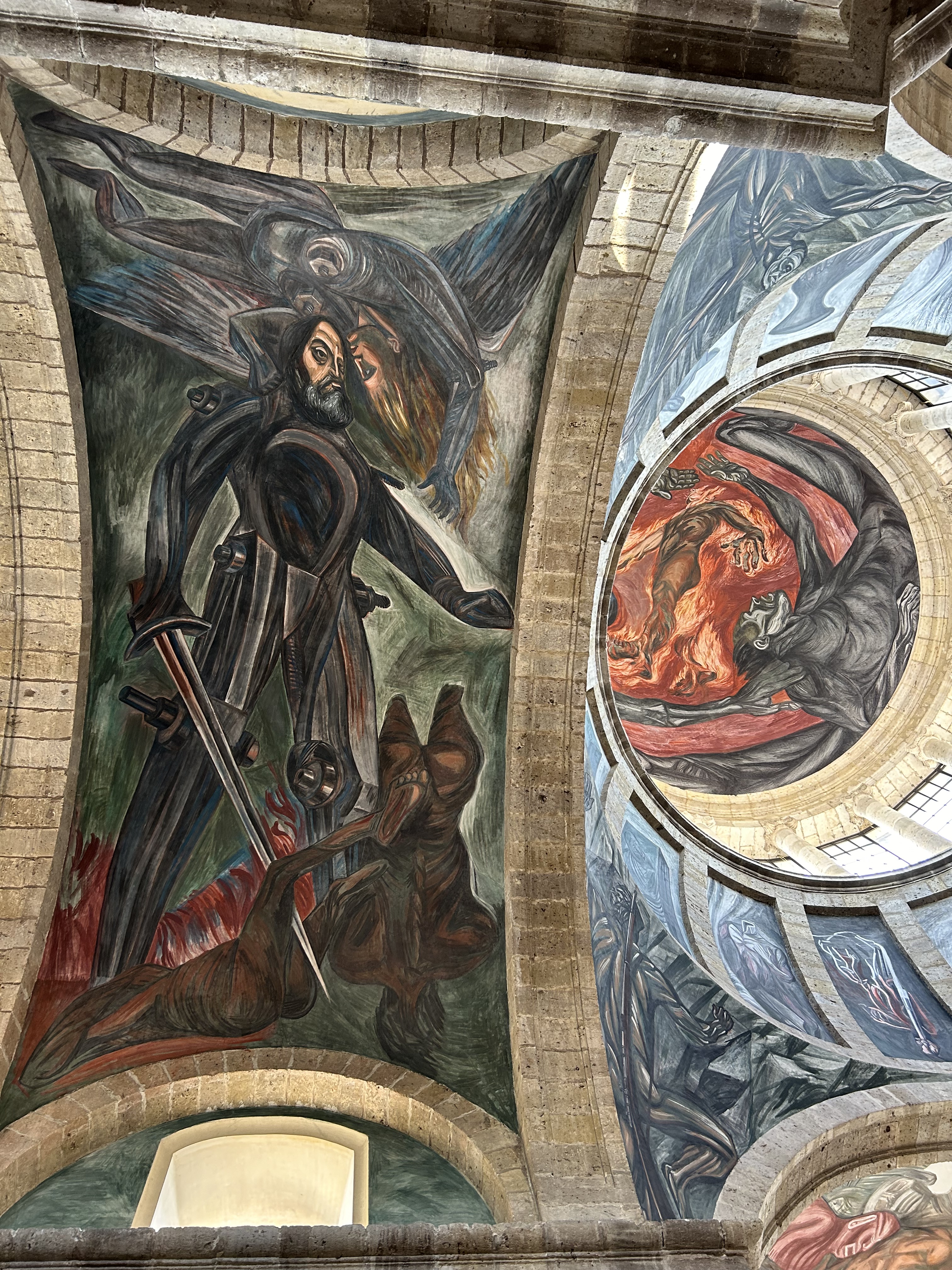
Originally designed to be a hospital, like Les Invalides in Paris, and named after the bishop, today the World Heritage Site in the historic heart of Guadalajara is a museum, with modern art outside and exceptional murals by Orozco inside. The central masterpiece on the ceiling of the rotunda is ‘The Man of Fire’, a modern version of the myth of Prometheus (in photo on right). I had seen Orozco’s earlier version in the Pomona dining hall in California, considered “the greatest painting in America” by Jackson Pollack. Orozco lost his left hand making fireworks at 21, and he was fascinated by the story of a man who risked his life and suffered to expand human knowledge and civilization, only to be punished by the Gods. He felt the myth was an allegory for artists, explorers and reformers who were punished by conservatives for their efforts to bring enlightened change to the people. Every alcove and wall tells a story of both progress and betrayal, of historic accomplishments and dark consequences.
Prometheus stole fire from the Gods, but today we struggle with the consequences of burning carbon. Fossil fuels helped us achieve great things, but there are always consequences. Struck by the inescapable conclusions of the art here, we see that conflict over ‘progress’ often results in suffering, especially among the poor. Murals require us to step back, to try to see the bigger picture. We can build hospitals, and we can also destroy whole cultures. We can choose sustainable fuels, or we can let powerful men perpetuate destructive fuels. We may believe ourselves invincible and deserving of the powers of the Gods, but our actions come with destructive consequences that we must try to see, understand and prevent. We must give up fossil fuels, or our world will burn.
I arrived at this World Heritage Site on Sunday late morning, and with a minor miracle I found parking one block from the cathedral above. When I stepped inside a beautiful mezzo-soprano voice echoed through the high ceilings and alcoves. What a spectacular and moving service!
The city and state are named after José Morelos, born a block behind the cathedral (now a museum), a priest in the cathedral, who answered the cry for independence and supported multi-racial equality. Morelos also demonstrated remarkable skill as a military strategist, and after Hidalgo was executed in 1811, Morelos became the leader of Mexican Independence. After dozens of victories that roused the insurgents, Morelos was eventually captured in Puebla, tried by the Inquisition, defrocked and executed near the end of 1815. He is remembered as one of Mexico’s founding fathers.
Full disclosure: the three houses here were being renovated the week I was in Mexico City, and it is only on the tentative UNESCO World Heritage Site list. Architect & artist Juan O’Gorman had the complex built for the famous couple while they were touring in the US in 1931-32, and their patrons the Kaufmanns, of Fallingwater, visited the couple here in the upscale San Ángel neighborhood in 1938. The big house and studio in the front was Diego’s, the blue one was Frida’s, and O’Gorman lived in the third house in back. There’s a bridge between Diego & Frida’s homes. This arrangement worked for about 5 years, but then they divorced.
To be clear, Frida’s blue house above is not La Casa Azul, The Blue House, where Frida was born and died. That more famous one is in the Coyoacán neighborhood less than an hour’s walk away. Frida hosted Leon Trotsky there, after helping him get asylum, although he was ultimately assassinated in his home nearby (now a museum). Diego & Frida remarried and lived in her original home until her death, keeping the complex above as Diego’s studio. Diego Rivera donated Frida’s Casa Azul as a museum, and it’s one of the most visited sites in the city. Tickets to her home and museum are essential to buy online well in advance, as they recently stopped offering in person ticket sales.
Luis Barragán was an architect from Guadalajara around 1930, after WWII he designed projects in Mexico City, and he produced many influential works through the 1970s. Primary colors, smooth walls, angular structures and exceptional lighting is how I would describe his style. When he purchased the land for his home and studio, it was on the outskirts of Mexico City, but now it’s central. The modern architecture tucked into a narrow upscale neighborhood south of Chapultepec park looks like some nouveau riche shoe-horned it in, instead of being the original that inspired so many followers.
OK, the photo is across the street from #14, and I couldn’t actually get a ticket to tour the inside. There are only a few tours a week, and they sell out online quickly. Even the bookstore wasn’t open when it was supposed to be. Oh well, technically I arrived at this architect’s home by electric vehicle, the Metro, which was cheap and convenient. If you are a visiting professor of architecture, you can probably arrange a tour of this World Heritage Site through your university. But there were a few disappointed common folk outside. Maybe architecture isn’t meant for the masses?
The Plaza Santo Domingo in the historic center of Mexico City is the southern terminus of ‘The Royal Road of the Interior Land’, a World Heritage Site. As you can see above, some vendors still use traditional market stands on this trade trail first developed by pre-Columbian empires. The whole trail was originally a native trading route for turquoise, obsidian and feathers, and after the Spanish conquest, it was used for military, religious expansion and for silver. From this plaza, the road runs north through San Miguel de Allende and Guanajuato all the way through El Paso (‘the pass’) to Santa Fe (‘holy faith’). The US section—with the same Spanish name—is a national historic trail.
In the background is the Palace of the Inquisition, which arrived from Spain to punish the son of Hernán Cortés, Martín, who threatened independence in 1566. Public burnings of witches and heretics were common for ~250 years, until Mexican Independence ended the practice in 1820. The ‘palace’ now houses a UNAM medical museum, although there is a small gory museum of the inquisition a few blocks away. Mexico City is the largest and oldest city in North America, and it is well worth visiting to be able to walk in the footsteps of history.
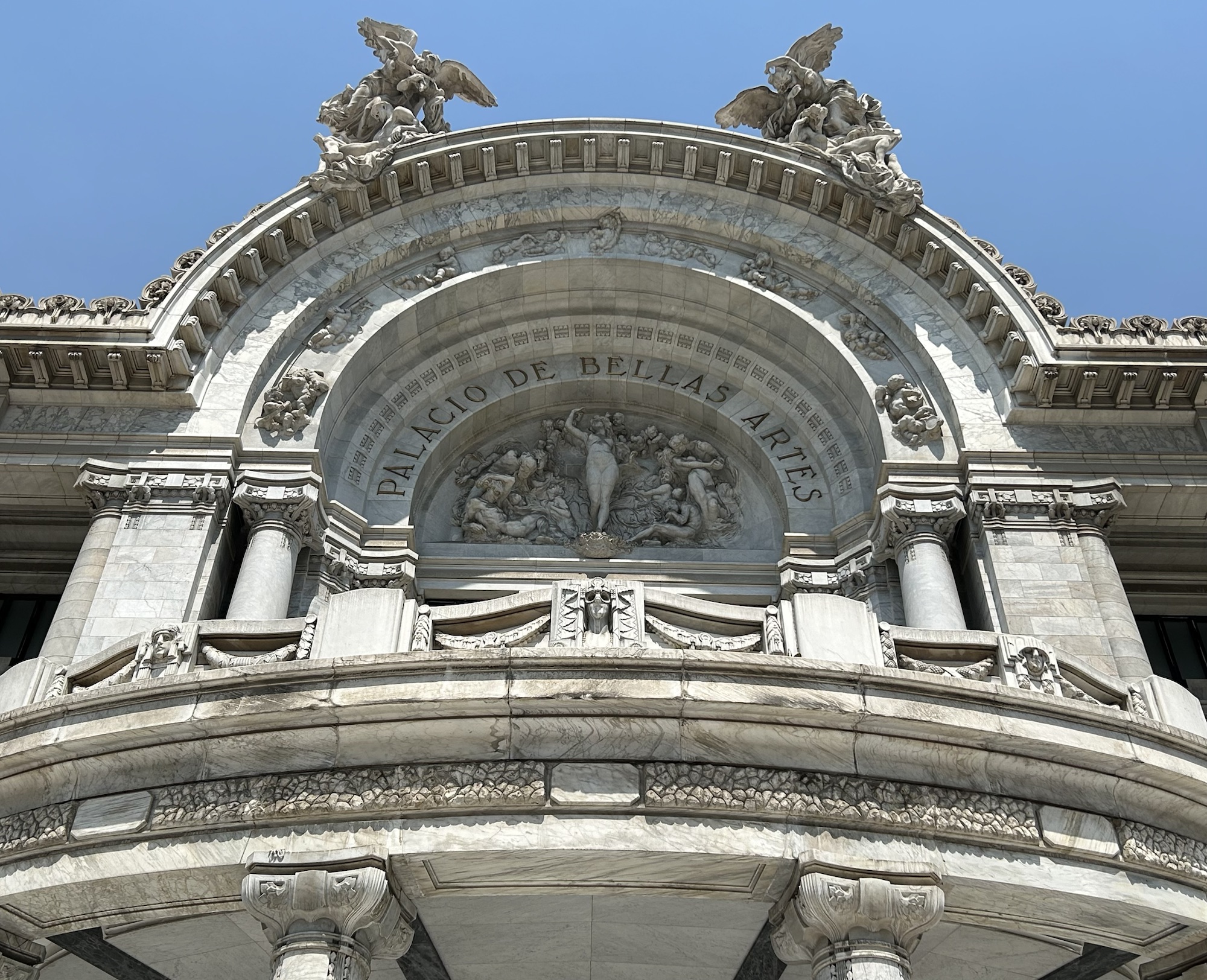
In the US, the Independence War means the same as the Revolutionary War, but in Mexico, they are two different wars. 100 years after Hidalgo cried out for Independence from Spain in 1810, the country was under the control of the dictator Porfirio Díaz, who ruled for 35 years over a growing gap between the elites and the masses. He commissioned the ostentatious building above to celebrate his rule, but it ended up celebrating the end of his rule after the Revolution of 1910-1920. Since the common people were uneducated, the new era of called for artists to paint huge public murals to tell the story of Mexico. The three great muralists were Diego Rivera, David Alfaro Siqueiros and Jose Clemente Orozco. All three have murals on permanent exhibit on the oversized second floor inside. Siqueiros uses stunning, clear images to depict the drama of human suffering and bondage. Orozco contrasts vivid lives with cold modern weapons. And Diego Rivera presents his profound understanding of social struggle, using historic figures, ancient images and modern allegories, to awaken people.
The historic center includes far more than one museum, but to appreciate it, you need to understand what’s buried beneath the metropolitan cathedral, grand government buildings and the huge public square. Once there was a lake ringed by volcanoes, and the Aztecs built an empire around an island, using landfill and bridges to create a moated city. Thousands of captured warriors were sacrificed publicly and walls of skulls have been uncovered. From this easily defended base, rich with food grown on floating gardens such as at Xochimilco, over 200,000 lived here, with a sophisticated canal system and extensive trading network. When Hernán Cortés arrived here in 1519, it was one of the largest cities in the world. After building boats and bringing in cannon, the besieged city fell, and the Spanish drained the lake, tore down the temples to make a cathedral, and paved the ruins of the temples and markets to make the huge, empty square Zócalo public space, where over 100,000 now gather to hear the President speak from the balcony of the National Palace or to listen to pop music stars perform. Begin in the Zócalo and take the walking tour to learn about the excavated Aztec ruins and much more in this fascinating, important and historic city center.
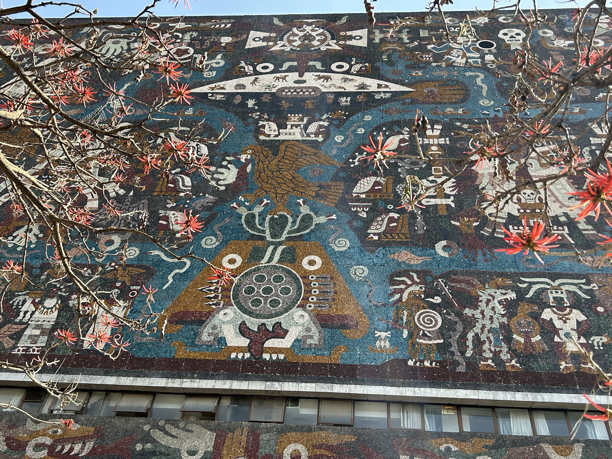
University City, the main campus of UNAM, the National Autonomous University of Mexico, is a World Heritage Site, and it was founded in 1551, just four months after the oldest university in the Americas was founded in Peru. It is autonomous, meaning free to teach without government interference, although the PRI government did kill hundreds of students in 1968, during the Tlatelolco massacre. The faculty and alumni include all Mexican Nobel winners to date. The north face of the 10 story Central Library (above) is covered with Aztec mural mosaics by Juan O’Gorman, friend of Diego Rivera.