There are 18 NRAs managed by the park service for biking, boating, camping, fishing, hiking, horse riding, swimming and other activities. (I should note that there are also 13 NRAs managed by the US Forest Service, and I plan to visit some of those too.)
Two are in the North Atlantic region: Boston Harbor Islands and Gateway, which is shared with the Mid-Atlantic region. Both are great for birdwatching and hiking along the shorelines.
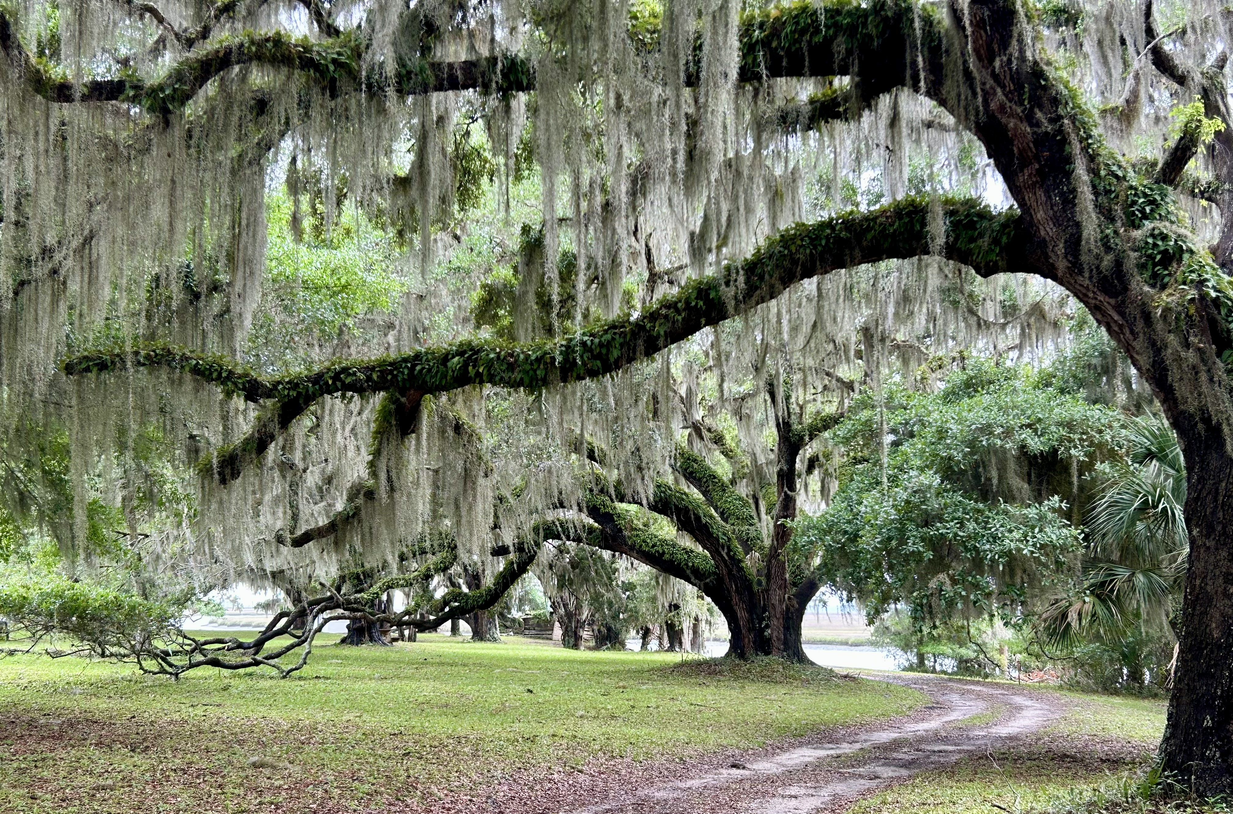
Decades later, I returned to see the southern live oaks that have haunted my dreams. Now I know the ferns that grow on the tops of their branches are called resurrection ferns, since they revive to a bright green after it rains. As a teen, I was told that humans could eat the Spanish Moss that hangs down from their branches, but returning as a tourist I was told that no humans ever did, only horses. I was too ashamed to admit I ate some long ago and thought it tasted OK.
Since I had been to the island before, I knew the only way to get to the north end on a day trip was to take a tour, so I joined the NPS recommended van tour and got to see everything from the settlements at the north to the Dungeness ruins in the south. The photo above is behind the Plum Orchard mansion, one of a few Carnegie family homes built on the island. The Carnegies were excluded by the other billionaires on neighboring Jekyll Island, so many of them settled here. Plum Orchard is beautiful and has interesting innovations, but plantation style troubles me. The center of the island is protected wilderness, and it feels like an ancient forest or overgrown jungle. Along the way we saw wild boar, wild horses, an alligator, several armadillos, and many beautiful birds.
I don’t always try to draw historic connections between parks, but bear with me this once. The natives here were related to the Timucuan. The Gullah Geechee (next week’s post) descendants of slaves are related to those all along the coast up to Reconstruction Era and down into Florida. The southern live oaks from this island were used to build the “iron sides” of the USS Constitution in Boston. Nathaniel Greene, commanding general of the Southern Campaign of the Revolutionary War, died shortly after retiring near Savannah Georgia, and his wife remarried and moved to Cumberland Island. There, Greene’s daughter Louisa cared for one of his cavalry officers, Henry Lee—veteran of Eutaw Springs—, before his death and burial at Dungeness mansion. Lee’s son was Robert E. Lee of Arlington House. And, if you want one more parks connection, the Carnegie’s innovative household DC power was likely overseen by Thomas Edison.
When I first arrived on the island several decades ago, I was invited as a guest of someone who knew the owners into a grand old home under the oaks for a meal, stories on the porch and an after dinner cognac, my first. As I recall, there was some discussion about whether the home would have to become an inn to survive, and we all agreed that it was important for beautiful old historic places to be preserved. (It later became the exclusive Greyfield Inn of Kennedy wedding fame). Folks need to come to places like Cumberland Island to try to imagine what it was like all those years ago, to walk along the barrier island beaches, to see the wild horses, to learn about dugout canoes, see photos of Primus and Amanda Mitchell who went from slaves to church and settlement founders, to learn about sea island cotton, and especially to feel the special old grandeur under those southern live oak trees.
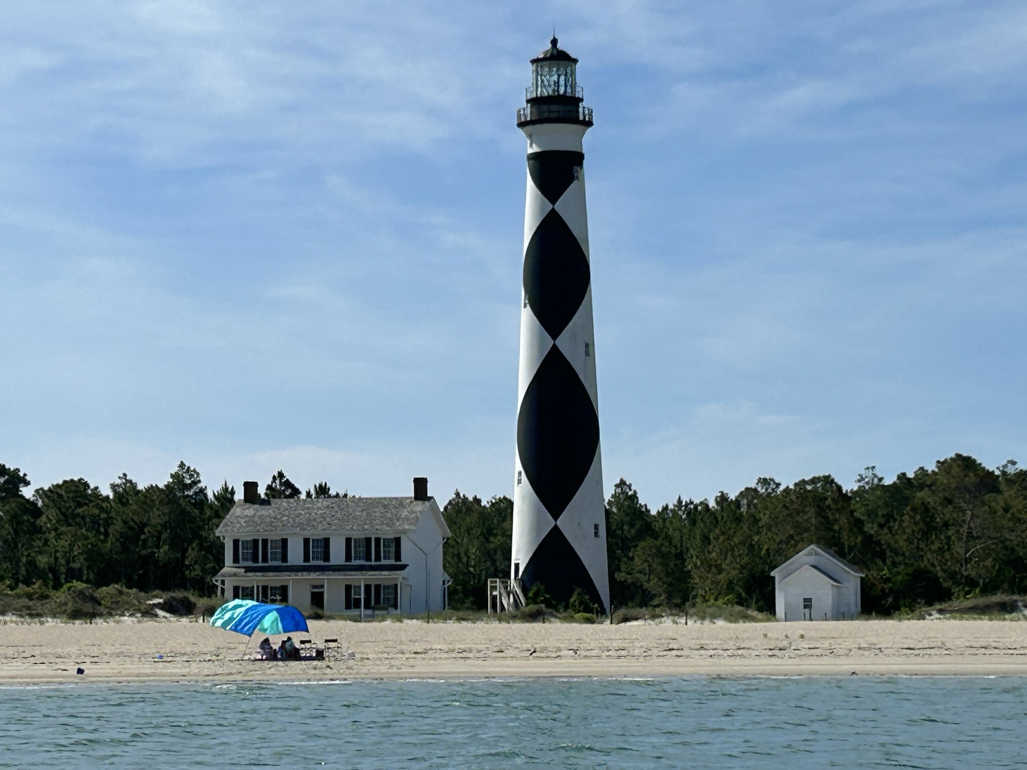
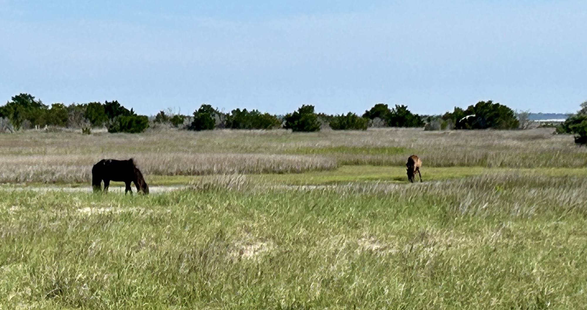
The ferry pilot told me that this is the best view of the Cape Lookout Lighthouse, so there you go. Seeing wild horses was quite simple at Shackleford Banks, as there aren’t many places to hide. And the horses don’t seem to mind photos while they’re grazing.
A few decades ago, I came through the Beaufort Inlet on a boat to resupply. The docks and front street of Beaufort NC—not to be confused with Beaufort SC—haven’t changed much, although everything is quite a bit busier and pricier now. I don’t remember seeing any horses, although we knew they were there.
Unlike the rest of the Outer Banks to the north, Cape Lookout’s barrier islands have no paved roads. A few fishermen and visitors bring cars over on a vehicle ferry from Davis to Great Island Bay, and there’s another vehicle ferry from Atlantic to beach camping on North Core Banks. There’s also a passenger ferry from Ocracoke to the north end of this seashore at Portsmouth Village. And concessionaires run ferries both from Beaufort to Shackleford Banks and from Harkers Island—where I left from—to both Shackleford and the lighthouse. Yes, that’s five different ferries from five separate locations to five disconnected destinations, depending on your plan.
The seashore is quite casual, parents with babies, school groups, many folks bringing their dogs, tourists looking in the light keeper’s house, campers, sporty teens, and some older folks appreciating the natural beauty while reminiscing. The beaches have many shells, and you are allowed to take a few home. Many boats cruise around the bays from nearby marinas tucked into the coast’s rivers, and I heard several small planes going overhead. I drove up when the Harkers Island visitor center opened, got a ticket, hopped off on Shackleford, hopped on the next boat for the lighthouse, hiked around a bit and returned to find some seafood. Of course there are miles of beach to walk. Very pleasant.
California’s Golden Age architect, Edwin Neff, designed a grand ranch, above, for King Gillette of razor blade fame, in the roaring ‘20s, who sold it to Clarence Brown, who directed dozens of successful films, including National Velvet and The Yearling. Later the property had numerous colorful owners, but eventually it was saved by conservationists who won national protection for the stretch of mountains overlooking the Pacific above Malibu. The recreation area includes state and city parks, numerous film locations, horse riding trails, scenic vistas and wildlife, not far from Santa Monica and the LA basin.
This was actually the first park I visited for this blog, on the same day I picked up my EV. But I was so upset by the devastation of Paramount Ranch after the Woolsey Fire, that I neglected to take a photo. So, since I driving by on Thursday, I decided to do this redux visit to get a proper photograph or three. The visitor center is in the old Gillette Ranch carriage house, with the horse stalls and round hayloft now an exhibit space. And if you walk up the hill, you get a grand view of the Santa Monica Mountains below.
The whole recreation area is fascinating, especially if you’re a fan of scouting old TV and film locations: the Rockford Files beachfront home/ office at Paradise Cove, M*A*S*H’s camp in ‘Korea’ and Planet of the Apes, including Zuma Beach where Charlton Heston famously dropped to his knees to curse us all.
Gateway is multifaceted, but for me the most important part is the Jamaica Bay Wildlife Refuge above. Here there are migratory and year round birds, butterflies, trails, groves of trees and pleasant views. The contrast between the busy planes of JFK and the mute swans could not be more striking. Although the road noise limited my birdsong app, I still lost count at a dozen species. With more time, I would have kayaked around to see more birds.
But for folks interested in other things, the park includes Forts Hancock, Tilden & Wadsworth, beaches, parks and more, spread out over western Long Island, Staten Island and Sandy Hook peninsula in New Jersey. The Sandy Hook unit has miles of beautiful beaches (below with NYC skyline view) and paved bike trails to enjoy.
The park extends from the fist to the elbow, from around proud Provincetown to historic Chatham Harbor, and there’s much to see and do. For me, the quintessential experience is to find an isolated stretch of beach and walk until the birds far outnumber the people. I saw dozens of grey seals swimming right near the shore or lying on the rocks just off the beach. It’s difficult to get to any beach without passing a lighthouse, but if you want to climb one, your best shot is Highland Light (above), the first one commissioned on the Cape by one George Washington.
There are about a dozen named trails too, and I’d recommend hiking near Fort Hill, where you can see the Penniman House, get a great view of the marsh, and spot many different birds. With the aid of a birdsong identifier, I counted 18 different species in one day, including the rare Indigo Bunting and an uncommon Willow Flycatcher.
If you have a bike, consider taking the Cape Cod Rail Trail, which is a high-quality dedicated bike trail through about 1/3 of the cape, and there are also other decent bike lanes and bike trails. My first bike trip here a few decades ago, extended the length of Cape Cod, plus the islands of Martha’s Vineyard and Nantucket, returning by ferry from Provincetown to Boston. When I last visited the lighthouse above, it stood where I stood to take the photo above, because the highland cliffs are eroding at several feet per year, forcing them to move the lighthouse in the intervening decades.
Visiting in shoulder season, rather than July-August, helps avoid miserable traffic and exorbitant hotel rates. There are also lots of good seafood shacks, still one or two cheaper motels, some campgrounds, and lots of nature. Wellfleet is well known for oysters, and the fried clams here are the best I’ve had. I’m still on a quest to find the best lobster roll, and I suspect it will be lifelong. Though speaking of seafood, I would be careful swimming around here, as great white sharks prowl along the shores.
The 32 mile narrow island park is interspersed with small communities of folks who have taken responsibility for protecting their long and fragile wilderness. Around Watch Hill there’s a salt marsh, home to many birds. Near Sailors Haven, there’s a Sunken Forest of centuries old Holly trees below protected by a double row of dunes. There are beaches, boardwalks, small boat harbors and historic homes within the park too. In 2012, Hurricane Sandy temporarily breached the Fire Island Wilderness, cutting a path from the Atlantic above through the dunes to Long Island Sound. You can cross the Smith Point bridge—while its replacement is being built—at the eastern end of the park and hike in from the Wilderness Visitor Center.
If you’re driving in from NYC, navigation software might direct you across the Robert Moses Causeway to the west end where you can hike to the lighthouse. But be aware that park ‘roads’ are limited to authorized vehicles, and visitors typically arrive via passenger ferry from places like Sayville. After just such a detour, I barely caught the Sunday ferry to Sailors Haven, my last chance to see the Sunken Forest below for a week during the limited fall schedule. Besides a stand in Gateway NRA in Sandy Hook NJ, this is the only grove of its kind in the world, and there’s a lovely boardwalk nature trail to enjoy the trees, birds and scenery.
The view above is from the Ramparts at Fort Warren on Georges Island, one of the 34 beautiful & fascinating islands. The fort didn’t come into play in the Civil War, except as a prison for Confederate soldiers. When I was here in my youth, I heard the spooky story of the Lady in Black, who haunts the cliffs and corridors. With the help of local sympathizers, she snuck into the fort, whistled a tune that her husband knew, found him but accidentally shot him during the escape. She was tried and executed for treason, in a dress she had sewn herself from black curtains in the commander’s office. Her shadowy ghost has been seen by many since the Civil War.
Alas for fans of the supernatural, the story is nonsense. Despite the obviously dramatic appeal, there are no contemporary records of the women herself, the escape attempt, the death of her husband, the arrest, the investigation, the trial or what would have been the first official hanging of a woman for treason during the Civil War. The story began in the 1950s or 60s to encourage folks to visit the old fort in summer. But apparently we prefer lies to the truth. And nothing cools you off on a hot day like sitting in a dark 65° man-made cave listening to a ghost story.
The islands have been also been used as summer fishing grounds by Native Americans, by pirates, smugglers, for quarantine, as schools or asylums, and as way-stations on the Underground Railroad. Outward Bound holds one of its programs on Thompson Island, which Nathaniel Hawthorne once described as “a little world by itself”. The School for Field Studies once hosted me (photo) and a few other whale watchers for a month on a boat, including a day writing up our research in the church on Peddocks Island. A few of the islands remained relatively unchanged since the glaciers receded leaving steeply eroded drumlin cliffs and long low sand-spits. But Spectacle Island had to be completely reclaimed from “trash island” to beautiful natural recreation area.
The Boston Harbor of Tea Party fame is in the inner harbor in the distance above. The Tea Party Ships & Museum on Griffin’s Wharf is not part of the park service, but it’s a fun hands-on spot to learn about ‘no taxation without representation’. The Harbor Island ferries mostly leave from Long Wharf near Faneuil Hall, which is on the Freedom Trail. The islands make a nice excursion if you’re visiting Boston during their open season from mid May to mid October. Since I had already traveled to the islands many times by sailboat, I simply rode the park-partner ferry out for a few hours to take some photos and reminisce. But as I write this today, I can’t help but think about tomorrow’s election. We owe it both to those who fought to create and protect our country and to our future, to hold tightly to our democracy, and vote.
Superior is the biggest, deepest and cleanest of the Great Lakes, and our most scenic lakeshore park is on the north coast of the upper peninsula of Michigan. Within the park are ~10 miles of dramatic 200’ cliffs, painted by various minerals washed through the sandstone, and the best way to see is by boat. The pastels, turquoise shallow waters, green trees, blue skies and waterfalls (below) are spectacular.
Besides taking a popular commercial tour of the most scenic section of the cliffs in a couple hours, as I did, it’s possible to kayak or to hike along the edge. Lover’s Leap (above) has only 3’ of water below, so don’t take it literally. The lakeshore trail—part of North Country NST—is 40+ miles over dunes, creeks, and long beaches, with many side trails exploring forests, marshes, and lookouts. Short hikes can be done near the ends of the park, but the middle is roadless.
Above is the northeast point of Devils Island, the park’s northernmost island. The sandstone is more finely layered here, a bit softer and exposed to Lake Superior, so it erodes into caves, arches and beautiful shapes, under the lighthouse, quite photogenically. I briefly considered taking my own boat, but the distances are more than I realized. The largest island (left out of the park) is roughly the size and shape of Manhattan, with “1.5 hundred residents”. One does not simply paddle into the Apostles without serious preparation and proper gear. So, like most tourists, I took the efficient new catamaran from Bayfield. (While I arrived without burning carbon, I sometimes use park transport to enjoy places). The tour lets you see many of the 20+ islands in just a few hours. Guided kayak tours are also available.
Several of these beautiful Wisconsin islands are off limits, but most have one or more individual primitive campsites accessible by kayak, private boat or water taxi. Some of the wildlife is very difficult to see; martens weren’t seen on one until wildlife cams were installed. But from the comfort of the tour boat, we stopped to turn around and get a good look at a bald eagle nest, with a nesting pair visible. We also saw mergansers, nesting gulls and other birds. Bear and deer are only rarely spotted while swimming between islands. This is a large and important refuge for species that were once common all around the Great Lakes, and getting out among the islands is easy and worthwhile. If you have the chance, the colorful old Greunke’s Inn, near the dock, serves whitefish liver, a delicacy they popularized in the 1940s.