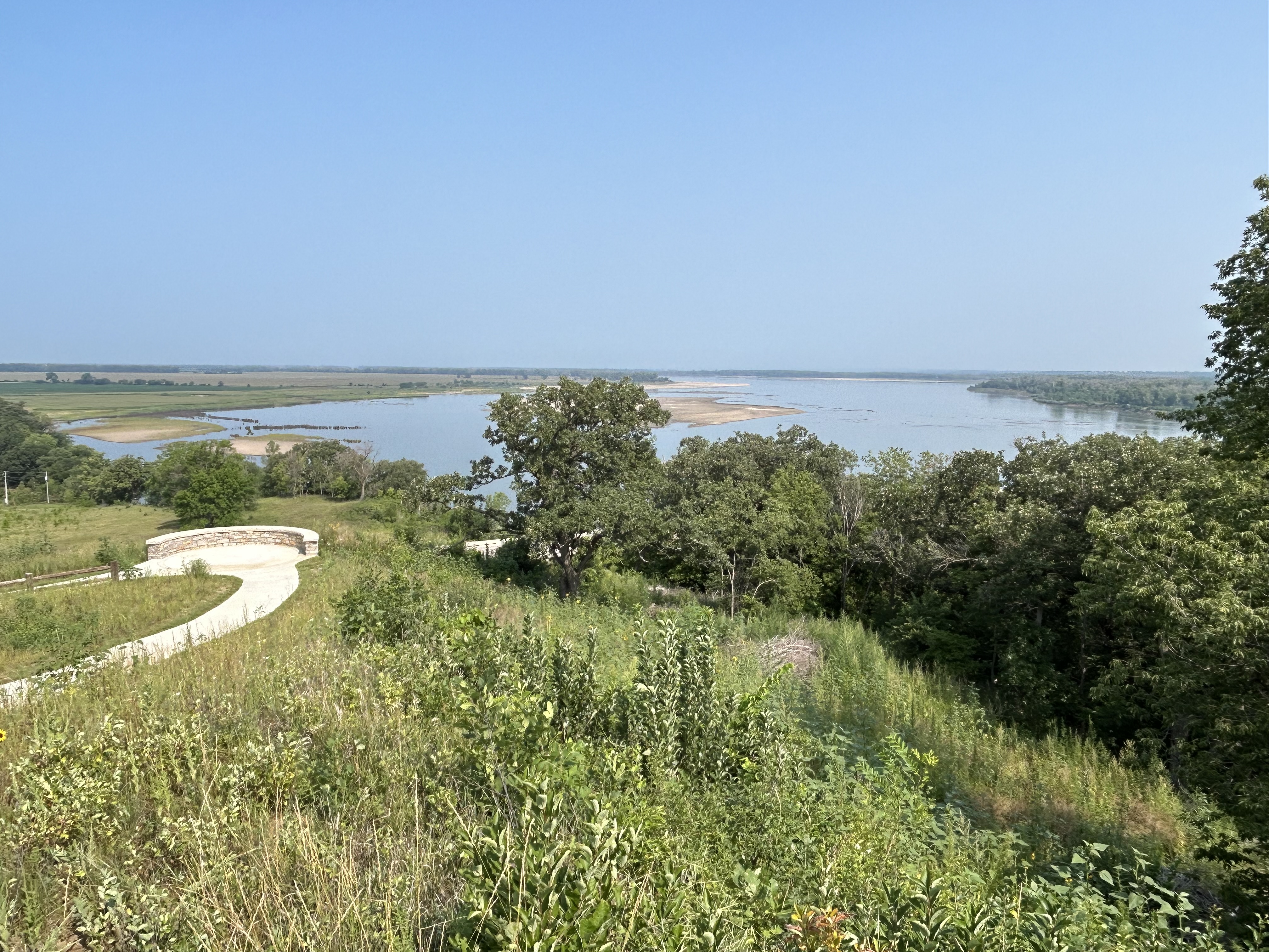
The small lake on the right is Glen Lake, and Lake Michigan is at the top left. If you zoom in to the right, you might see tiny people climbing the middle dune from the parking lot. I got up to this vast view on the pleasant Cottonwood Trail (less than 2 miles round trip) from the Pierce Stocking Scenic Drive, which also takes you to the breathtaking Lake Michigan Overlook and the splendid Sleeping Bear Overlook. Many folks seem to want to do things the hard way, but I definitely recommend hiking from the scenic drive. The impressive Sleeping Bear Dune itself is over 1000 feet high, and folks frequently need rescuing ($3,000) after climbing down to the lake and not being able to climb back up. A few extreme winter folk ski down the steep dune to the lake. Not sure how they get back up. Please stay on the trails, as past humans caused much erosion damage to the fragile ecosystem here. This is a beautiful park with wildlife, deep Native American roots, and it is part of a new UNESCO Biosphere across northern lower Michigan.
While I like the park and plan to visit it again in warmer weather, the seashore skips over the most important section in the middle. In Mississippi, the park includes the Davis Bayou (photo below) with a nice visitor center and park film, and from mid-March to October you can take a ferry out to Ship Island, look for bottlenose dolphins, explore the beaches and visit a Civil War fort. In the Florida section of the park, there are also birds, long stretches of storm-swept and once segregated beaches, old forts first built by the Spanish and later used by the Confederacy, and another visitor center (closed when I tried to visit) to explore near Pensacola. But the Gulf Islands of Alabama are not part of the national park unit. Forts Gaines and Morgan, the guardians of Mobile Bay, are Alabama State Parks. But that’s where the action was.
General Grant relied on combined naval and land forces to take Fort Donelson in February 1862, which cut off the Cumberland River from the Mississippi. In April, Flag-Officer David Farragut (depicted by Gaudens above) began his gulf coast campaign by sailing up past the forts guarding the Mississippi and taking New Orleans. After the Union freed the city, three regiments of African American troops were quickly organized, and many of those men first served on the Gulf Islands, helping retake the forts along the gulf coast. In June, Farragut was wounded near Vicksburg.
The Confederacy’s last large port was Mobile Bay. In 1863 the Union took Vicksburg, but to speed the end the war, now Rear Admiral Farragut needed to sail past the forts guarding Mobile Bay. In 1864, the Confederacy, having learned from their mistakes in New Orleans, had heavily reinforced Mobile Bay’s naval defenses among the many fortifications along the Gulf Coast. Fort Gaines guarded the shallower west side of the bay, and Fort Morgan guarded the deep water ship channel from the east side. The gaps were filled with floating sea-mines, called ‘torpedoes’ at the time. And the port was guarded by the massive ironclad CSS Tennessee, the most powerful warship in the world.
Farragut had four small new ironclad ‘monitors’ leading his fleet: the Chickasaw, Manhattan, Tecumseh, and Winnebago. He decided to run the gauntlet up the main channel into the large bay, boldly trying to move fast and far enough to get out of range of Fort Morgan’s guns. Under fire from the fort, the Union navy advanced with its ships lashed in pairs with the monitors on the side taking the heaviest fire. Farragut climbed into the rigging to get a view above the thick smoke. The Tecumseh crossed a mine field to engage the Tennessee, exploded one and sank immediately with 93 lost.
Seeing his fleet hesitating and the Tennessee closing in, Farragut yelled down something to the effect of “damn the torpedoes, full speed ahead!” The remaining monitors surrounded the Tennessee, disabled her and eventually blasted a hole, injuring the Confederate Admiral. The rest of the fleet entered the bay, got behind the forts, and shelled them. The Army, including African American regiments from New Orleans, approached the forts, which surrendered, first Gaines without much of a fight, and then Morgan after a heavy siege.
Mobile Bay was closed, cutting off supplies to the Confederacy. And the Confederate Army was tied down defending the city, helping open up Sherman’s march to Atlanta. While Alabama’s Gulf Islands are not part of the national park service site, they are in the middle of the line of hurricane barrier islands and sandy peninsulas where this major Civil War battle was fought on land and sea. Admiral Farragut and the Union Navy’s contributions to ending the Civil War must not be forgotten.
The choice is either to start at the dam in Montana and go up the canyon by boat or to start in Wyoming and take in the views from the rim. It was a long way for me to dodge power boats without easy stopping points, and the water level is obviously artificial. So, I chose to admire the views from above, passing through the wild horse refuge area and finding Devils Canyon Overlook above. I didn’t see any horses, but a turkey vulture flew right by my head so close the loud whoosh and sudden breeze startled me. Maybe he was hoping I’d fall over the extremely steep edge.
The topography of the area is disconcerting, as you see mountains & high ground and assume the Bighorn River would run south, but for all the uplift, the river has just carved its way deeper through the partially flooded canyon. Far upriver further south, it does the same thing, but there it’s called Wind River and cuts through Wind River Canyon. Ultimately, the basins and lesser mountain ranges in Wyoming matter far less to the river direction than the Rocky Mountains, which on this side of the Continental Divide cause the rivers like the Shoshone and Bighorn to flow east and north, joining here before flowing into the Yellowstone River on its way to the Missouri River. In the photo above, that flow is from the upper right to lower left, below the large shadow on the cliff across the canyon. The stretch of water in the upper middle, below the fans is Devil’s Canyon, partly filled by the dam’s backwash and sometimes fed by Porcupine Creek. The foreboding names match the inhospitable scenery. This is a rough and remote area, but it’s also starkly beautiful and dramatic.
The 700’ granite spire above that rises out of the Gunnison River at the confluence of Blue & Curecanti Creeks is the Curecanti Needle, formed by an earthquake fault running straight across the canyon. The half dozen turkey vultures in the foreground below it are drying out after a brief rain shower.
There are much more difficult ways to get here than driving to Pioneer Point Overlook, including climbing down hundreds of steps with gear and paddling down the river (and then back up), but I took the easy way. If someone is nice enough to build an overlook, then it’s best not to waste it.
Upriver from the Black Canyon, there are several dams and large basins with powerboats, and a very small, but pretty hike through the Cottonwoods along the riverside Neversink trail before the town of Gunnison. I skipped the artificial reservoirs and didn’t see any wildlife on the hike, but driving through colorful Colorado in early fall is always a pleasure.
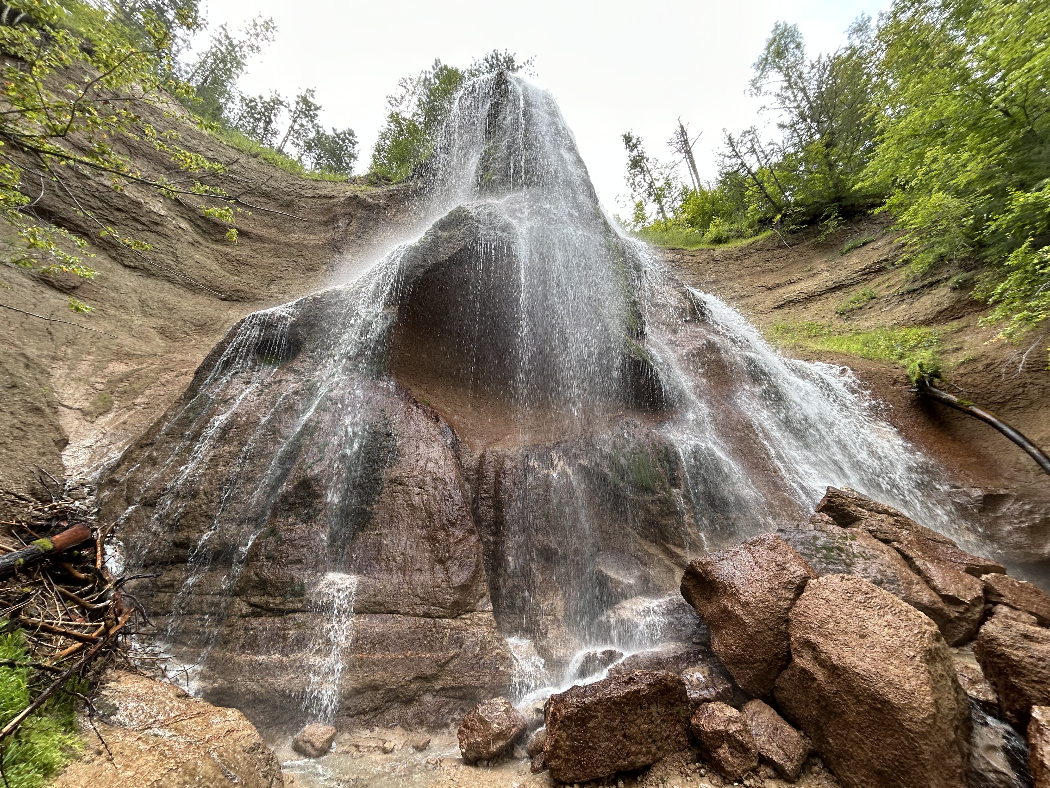
The 220’ three-tiered Whiskeytown Falls were a local secret known only to loggers and a few others until rediscovered by the park service staff in 2004. The ‘strenuous’ trail opened in 2006, and, since the shaded trail is in the 3% of the park not completely burned by the 230,000 acre Carr Fire in 2018, I decided to hike it earlier this summer, rather than broil on the water in my kayak.
But then these folks from Cal-Fire Bully Choop & Sugar Pine CC #9 passed me on my way up. Rather than complain, I gave them a bit of applause and thanked them for their heroism. They were taking turns cooling off in the 50° water. Of course, it’s not fair to expect these young people to risk their lives to protect our forests and property from the Climate Crisis we are all guilty of making worse, so they deserve our thanks all the more.
Shasta, Trinity and Whiskeytown Lakes are all National Recreation areas in the Shasta Trinity National Forest, with the first two managed by the US Forest Service and the latter by the National Park Service. Shasta is the largest, and you may have driven over it on I-5 in northern California. Whiskeytown is the smallest, but all three suffer from lower snowpacks and longer droughts due to climate change.
At the Whiskeytown visitor center, I noticed that they are using an underwater curtain to block the warm surface water from continuing downstream from the dam. This innovation helps keep the water temperature low enough for Chinook salmon eggs and fry in the Sacramento River. I’m not sure how long it will work given the Climate Crisis, but it’s the least we can do after damming Clear Creek. Maybe we could ban gas-powered boats too?
I was disappointed to read the park newsletter with three long articles about the fire and zero mention of the Climate Crisis. I expect my tax dollars to be used more wisely. Denying the crisis only gives us less time to act.
Defining much of the border between Minnesota and Wisconsin, this river and its tributary the Namekagon were among the first rivers protected by the Wild & Scenic Rivers Act, supported by Walter Mondale and many other locals 55 years ago. The forest was quickly and heavily logged 150 years ago, but the water remained clean. Even though there are several dams, including a hydroelectric one at Taylors Falls, the river is much healthier than most, especially the upper St Croix. Below the dams, near the Mississippi, there are power boats, a power plant and non-native mussels, but higher up there are dozens of native mussel species, various fish, otters, bald eagles, kingfishers, great blue heron, several different colorful warblers and more.
The forests have regrown too, so it can be difficult to get a decent view of the river. The photo is from the Minnesota state park ($5 to park) below Taylors Falls, and it has a a canoe & kayak rental, picnic tables and camping. Nearby you can catch the scenic riverboat pictured that offers views of the basalt cliffs shattered by glacier melt. I’m going to have to return a third time, since my first trip was during spring floods and this summer during extreme low water. I believe the best views will be paddling the upper St Croix from the Namekagon confluence to highway 70, but I need good conditions for the rapids.
The Wisconsin parks are $11 to park with very similar views and features. There’s also a waterfall at Osceola, but the bluff trail there is now called the Falls Bluff Trail Loop, or the Cascade Falls Trail or the Eagle Bluff Trail or maybe the Simenstad Trail or the Osceola Rivertown Trail, but not the Osceola Bluff Trail like the park map says. Fortunately, you can also see the waterfall from the road, and the Watershed Café is quite good.
The tiny tributary (above) of the Mississippi River is Coldwater Spring, one of the few parcels of land the park service owns here except for islands. Buildings were removed, plants planted, and the birds and butterflies have already returned. A mink was sighted a few days ago. Having a good spring near the confluence of the Minnesota River made it ideal for an early trading post. Eventually the twin cities of Minneapolis and Saint Paul arose, but, even though you can hear traffic, the spot is mostly wildflowers, prairie grasses, and old Live Oaks.
The trail will be ready in September, so I wasn’t able to walk down to the floodplain to see the Cottonwoods here, but they’re visible in other locations. Nearby are the Minnehaha Falls, named after Hiawatha’s love in Longfellow’s 1/2 imagined and 1/2 native lore mashup epic “Song”. Hidden Falls / Crosby Farm and Lilydale-Harriet Island / Cherokee park partner sites are also recommended for views and other activities. The main visitor center is in the science museum and has mainly kid-friendly exhibits.
“O, Shenandoah, I love your daughter, Away you rolling river. I’ll take her ‘cross yon rolling water. Ah-ha, I’m bound away, ‘cross the wide Missouri.”
American folk song
Above looks upstream from the hill above Mulberry Bend in the 59 mile eastern park district, where Lewis & Clark scouted some 219 years ago, along with other places introduced by the Yankton Sioux, one of many tribes that helped the expedition. The Yankton Sioux relinquished most of their land 165 years ago before either South Dakota (right) or Nebraska (left) were states, but they are still considered defenders of Pipestone in Minnesota. Their reservation runs along the north bank of most of the 39 mile western park district, above the confluence of the Niobrara, and they are park partners. Both districts of the park preserve the natural river flow, without commercial traffic, and most power boaters stick to Lewis & Clark Lake in the middle.
Further up the ‘big muddy’ Missouri River, at the confluence of the Knife River in North Dakota, teen mom Sacagawea joined their expedition with her French fur trapper husband and their infant. Like Pocahontas, her story is part of America, and similar stories are part of our heritage. As a child, I loved the song “Shenandoah” but was confused whether it was about the Shenandoah River in Virginia or the Missouri River. Turns out, Skenandoa was an Iroquois Chief, whose daughter was stolen by a French fur trapper and taken away across the wide Missouri River. Romantic stories about natives are part of our cultural heritage, albeit often one-sided. Especially given current tragedies of missing and murdered indigenous women, more effort—and funding—is needed to protect these women and tell more stories from a Native American perspective.
Smith Falls above is the largest waterfall in Nebraska, and it makes a good picnic stop when floating down river. I got a ride with Little Outlaw from Brewer Bridge up to Fort Niobrara and kayaked back. Most people start at Berry Bridge and just float down on giant tubes ‘lazy river’ style, but they miss the pretty part at the beginning. I suppose the nature reserve doesn’t allow alcohol, so that may explain it. Either way, it’s very pleasant, with thick grassy banks, high bluffs, a couple of Great Blue Heron, several smaller waterfalls and no boat engines.
The interesting little town of Valentine is a decent base, with the small visitor center and places to stay. It’s in a well known Dark Sky county, which makes sense since the area is remote & peaceful. There’s a large nature reserve to the south, where I spotted a bald eagle but no bison. With all the space, they should have even more wildlife areas. Somewhere downriver were likely hideouts of bank robbers Frank & Jesse James. There are a number of reservations in the area, especially in South Dakota. There are not many places to charge, so I had to plan and drive a little slower than usual. Be sure to try a Runza—meat pie/ sandwich—if you see the local chain restaurant in one of the larger towns. I recommend mushroom Swiss.
Ross Lake is atop three dams on the Skagit River which provides power to Seattle, but it still has some old growth forest near the visitor center which you can hike through on the River Loop and To Know a Tree Trails. Since the park is managed and surrounded by the North Cascades National Park, they run the visitor center. The Gorge High, Diablo & Ross Dams can all be seen in short hikes, and the good news this year after decades of tribal petitioning is that ‘fish passage’ will be added to all three dams! Hydroelectric power is zero carbon, but it must not be at the expense of salmon and other species that we’re driving extinct.
Anyway, I highly recommend those two hikes which total about three miles, and include waysides explaining the different types of trees, their niches in the forest and the natural cycle of wildfire. Another improvement would be building wildlife bridges along the highway & over the river, so that animals like Grizzly Bears could migrate between north and south sections of the park more easily. Well, in any case, Ross Lake extends to the Canadian border and has many paddle-in campsites for folks who rent gear from the resort or somehow portage their kayak around the Ross dam after paddling across Diablo Lake. Seemed like too much work to me to explore an artificial lake, but maybe if I had more time to try fishing, it would make a nice vacation.