This boiling mud pot in the Sulphur Works area is so close to the road that the shoulder has collapsed. There’s a parking area a minute walk away and the views include many other steamy volcanic features, rough landscapes broken by eruptions and snow in July. The trail to the larger Bumpass Hell area was blocked by snow from the parking lot. I didn’t care, since I’ve been there before with my kids, before the fire. We stayed at Drakesbad Guest Ranch with their amazing natural hot spring pool where we swam and floated under the Milky Way, one of my fondest memories of any national park.
In 2021, the 1 million acre Dixie Fire severely burned 70% of this Northern California park, mostly the wilderness area. With Mount Lassen over 10,000 feet, many of the trees in the park grow extremely slowly, so the fire damage will be visible for up to a century, assuming we don’t have another fire before the forest can recover. Like much of the park, Drakesbad Ranch is still closed, although most buildings were saved. The devastation is terrible to see.
The park newsletter does not mention the Climate Crisis in a complete denial of reality, but it did congratulate itself for ‘30 years of fuel reduction that decreased burn severity’. We now live in the Pyrocene Epoch, the Age of Fire, where man has created conditions for multiple million acre fires each year, when the most beautiful places can be destroyed in a few hours. Once we imagined our parks would be there for future generations to enjoy. Now we wonder if they will still be there for our next vacation.
The Ice Age National Scenic Trail in Wisconsin is now a NPS unit, so I will create a new entry for it. The trail will link most Ice Age National Scientific Reserves in the area, which are NPS affiliates. The Ice Age Floods National Geologic Trail runs from Montana to the Pacific Ocean. I’m keeping this post about all three together here.
Wisconsin’s scenic trail curves around the edge of the last ice age glacier 26,000-10,000 years ago, which covered the north near Lake Superior and east near Lake Michigan with a massive ice sheet. The trail extends from near the confluence of the Mississippi and St Croix Rivers east towards Michigan’s upper peninsula, south to Madison and back up the Door Peninsula between Green Bay and Lake Michigan. South and west of the trail contains both an area that had glaciers before that and a ‘driftless’ area without signs of glaciation. The glaciers stripped the earth of many layers of soil, leaving a flat land of lakes with short forests. The Wisconsin Dells, with its horizontally carved lines in the rock, is at the edge of the last glacier and the driftless area, where the ice sheets pressed and cut into landscapes that had not been glaciated before. From there the Wisconsin River flows down through the gentle driftless area to meet the Mississippi near Effigy Mounds. Frank Lloyd Wright build Taliesin in the driftless area, which reminded him of the verdant rolling hills of Wales, which were similarly carved by glaciers.
The simple geologic explanation for the vast floodplains and dramatic gorges, is that the ice melted, repeatedly collapsing ice dams between mountains, releasing huge waves of water and reforming the landscape. Much of the rich farming soil we depend on was placed there in a natural climate change event. Washington state produces billions of dollars worth of produce annually on those floodplains, including apples, milk, potatoes, wheat, beef, hops, hay, cherries, grapes and onions.
What some folks don’t seem to understand is that while the end of the last ice age was ‘sudden’ in geologic terms, man-made climate change is exponentially more abrupt. Imagine a deer seeing a hiker slowly approaching on foot and choosing to flee by jumping into the woods. Now imagine a deer seeing a truck approaching at 75 miles an hour and not having time to respond. That’s the difference between natural and man-made climate change. We don’t have time to stare into the headlights.
The cloaked inhabitants can’t be seen on Wizard Island under Watchman’s Overlook above, nor can the massive moss beds in our nation’s deepest lake. But there’s plenty of evidence of volcanic activity, including lava flows, cinder cones and the caldera itself. The lake is restricted, but there are a few summer boat tours from Cleetwood Cove. The rim road on the far left side is often under construction, but there are many trails and overlooks elsewhere including from the Rim Village off to the right. Due to snow, the Scenic Rim Drive is usually closed from November through June, if not longer. The outside of the mountain is also worth exploring, such as a one mile hike through Godfrey’s Glen in the south. Signs of 2017 wildfires are seen near the north entrance, and the forests of Oregon are getting hotter and drier due to carbon pollution.
I’m finally catching up on my summer travel backlog, just California national parks for the remaining Mondays of the year. Thursday posts will also continue eclectically.
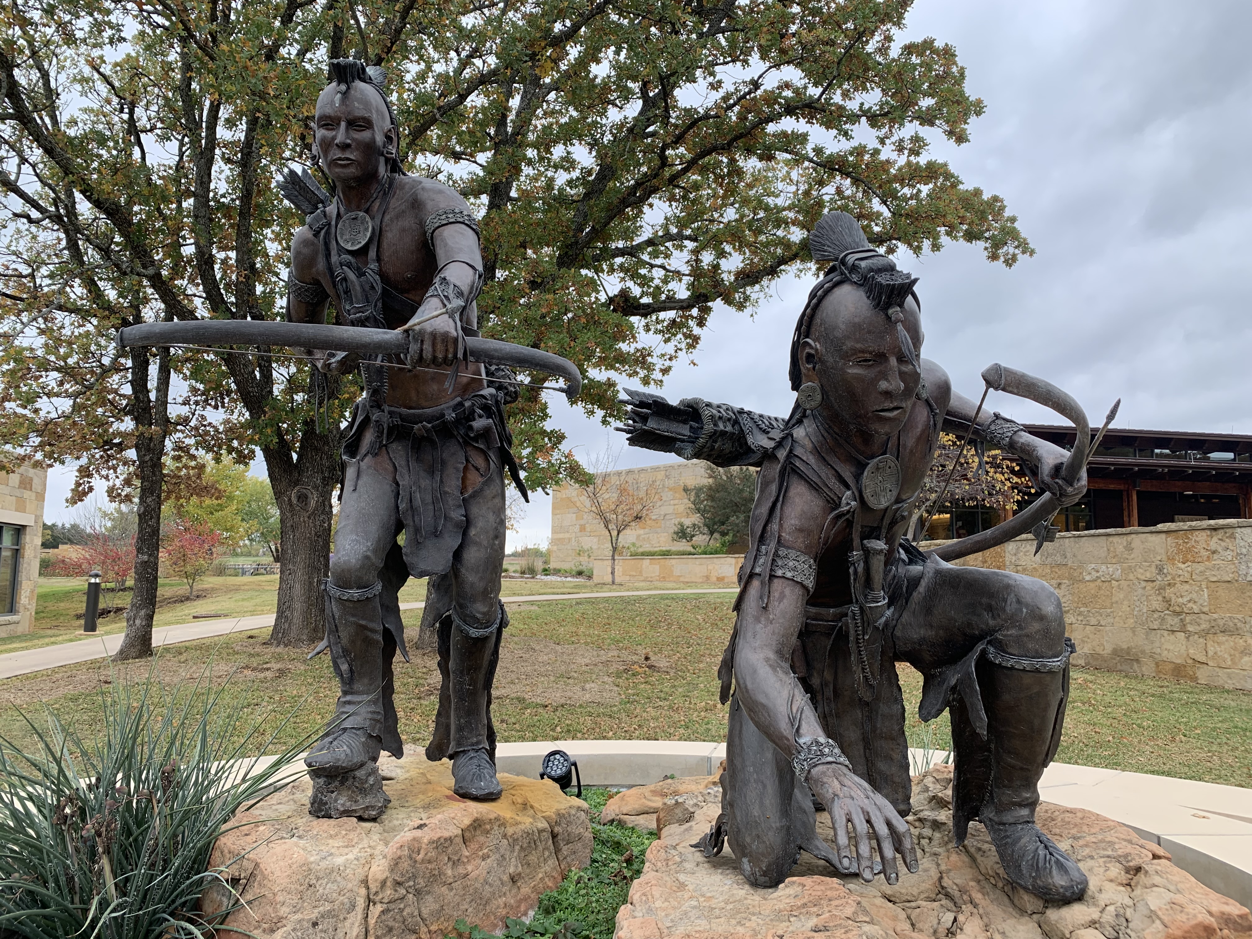
The trail is a crime scene, but we must remember, understand, judge and commit ourselves to being better. In the early 1800s, the Cherokee, Chickasaw, Choctaw, Muskogee (Creek) and Seminole tribes in the southeast were trying to balance their own culture while adapting to new ways of life. Sequoyah had created a Cherokee alphabet by 1821, and many had assimilated into the new communities, often through intermarriage, building homes, farms and businesses alongside immigrant families.
But many voters (at the time white males) had deep racist fear and hatred of Native Americans (and also wanted their land), so they voted for politicians who would remove the tribes. Andrew Jackson had a successful political career, and purchased a plantation and over a hundred slaves to work it. Appointed a colonel in the Tennessee militia, he gained national fame during the War of 1812–an expansionist war of choice against Native Americans and their British backers: “Remember the Raisin”. Jackson led troops including regiments from some of the five ‘civilized tribes’ above in the slaughter at Horseshoe Bend in 1814. One of his soldiers was Sequoyah, who saw first hand how the rebellious ‘Red Sticks’ were cut down by superior weapons. Jackson used the victory to betray his Native American allies by forcing the Muskogee who had fought on both sides to cede almost half of Alabama and much of southern Georgia in the 1814 Treaty of Fort Jackson.
Within 10 years of Horseshoe Bend, the Chickasaw had ceded 1/2 their territory, along the Mississippi River in western Kentucky and Tennessee (between Shiloh and Fort Donelson), retaining much of northern Mississippi (around Brices Cross Roads and Tupelo). The Choctaw lost their land near Vicksburg, and lived south of the Chickasaw. The Muskogee were restricted to a fraction of their land around Horseshoe Bend in eastern Alabama (around the Freedom Riders Monument). The Seminole had lost around 1/2 of Florida and lived in the swampy center. And the Cherokee still held their land in the mountainous corner of Alabama, Georgia, Tennessee and North Carolina, from Little River Canyon—which became a waypoint on the trail—and Russell Cave—which had been continuously inhabited for 10,000 years—, to Kennesaw Mountain and Chattahoochee River up to Chickamauga and Chattanooga, and up to the Smoky Mountains. (Yes, much of the Civil War was fought over land stolen from natives 50 years earlier).
Jackson is remembered for winning the Battle of New Orleans, but we should also remember the aftermath of the War of 1812, which ended when John Quincy Adams negotiated the Treaty of Ghent. Spanish Florida had been allied with the British, who had forts on the Panhandle. When they withdrew, they gave over one fort to a group of Seminole and African Americans. This became known as the ‘Negro Fort’ which caused great concern among those who benefited from slavery in the southeast. General Jackson sent in forces, and the fort was leveled when a cannonball hit the powder magazine. The Seminole Wars continued for decades, and the history of natives, African Americans and negotiations over Florida is fascinating.
Adams, who supported financial compensation for the five tribes, won a contingent election for President in 1824, but then Jackson defeated Adams overwhelmingly in 1828 and was reelected in 1832. As President, Jackson refused to follow a Supreme Court ruling in favor of the Cherokee, and he supported segregation of natives and both state and federal jurisdiction over native land. Jackson supported and signed the ‘Indian Removal Act’ of 1830, intending to remove the five tribes from their remaining land. Tens of thousands of Cherokee, Chickasaw, Choctaw, Muskogee and Seminole were removed from the southeast and relocated to Oklahoma with thousands dying on the forced migration trail: rounded up and held in forts, with few possessions, homes looted, families separated, marched under guard, some in chains, suffering cold and exposure, denied medical help, including women, children and the elderly. Stops along the way included Arkansas Post, Little Rock, Pea Ridge and Fort Smith in Arkansas and Wilson’s Creek in Missouri.
The historic trail focuses on the Cherokee, but the removal act was for all tribes east of the Mississippi. The Chickasaw (see photo above) were able to sell some of their land and moved first. The Choctaw were cheated by treaty but moved too. Many Seminole continued to fight, with some moving to Oklahoma and others to reservations deeper in central Florida. The Muskogee ceded their public land to Alabama, and Jackson refused to defend their private property from being stolen. The rest moved after the Creek War of 1836. The Cherokee also lost their land that year in a treaty their leaders didn’t sign. Jackson used bribery, fraud, intimidation and war to effect the removal. Over 70,000 Native Americans living east of the Mississippi, including the north, were removed under his policies for 8 years and enforced by his Vice President and successor Van Buren.
Some of the Cherokee hid in the mountains, and their descendants still live in towns like Cherokee, on the southern border of Smoky, where you can see signs in Sequoyah’s written language. Eastern Oklahoma territory became tribal reservations for the Cherokee in the north, Chickasaw in the south, Choctaw in the southeast and both Muskogee and Seminole in the middle. Today, the tribes there thrive, have found ways to come to terms with the trail’s brutal history and have chosen to move forward. This is an inspiring example to face the facts, recognize the evil acts and resolve to be better people.
Even though the Hoh Rain Forest is on the far side of the park from Seattle, it’s popular in July, so I watched an otter playing in the water for half an hour while waiting my turn to drive through the gate to look for parking. (A parking map at the gate would save everyone time). The Hall of Mosses Trail above is easily hiked from the visitor center, and it’s impressive and definitely worth the trip. Several of the trees appear to be 1000 years old, and the streams are clear from spring water, where I saw tiny salmon among the bright green watercress.
There are some signs that the increased heat from carbon pollution is damaging some of the mosses, and while the overall annual precipitation has remained the same, it’s more concentrated in heavy downpours and less in the misty fog-drip that these sensitive plants require. The glaciers are also disappearing rapidly and will disappear completely in a few decades or less, severely impacting all the downstream ecosystems. Still, it’s my favorite park for moss.
Of course, Olympic also has mountains, including Hurricane Ridge and Mount Olympus, which feeds the Hoh and Queets Rivers. There’s a Hot Springs resort at Sol Duc and boating at Lake Crescent. The Olympic Peninsula also has Native American Reservations which help manage the coastal wilderness, wildlife refuge and marine sanctuary. For me, their crown jewel is their large temperate rainforest, but the other areas are also stunning. Some artists are painting the glaciers before they melt, but wouldn’t it be better if we all did our part to reduce our carbon footprints?
Thomas Jefferson’s Monticello home has maps and mementos from Lewis & Clark’s expedition all over his front hall, showing how interested he was in the Native Americans, geography, flora & fauna, and other discoveries. He also had strategic interests in mapping both the huge Louisiana territory he purchased from France and the further lands to the Pacific. Having read Captain Cook’s voyages, he was interested in discovering any practical, cross-country trading routes.
And there was plenty of competition. De Anza had explored up the coast to San Francisco in 1776, and the Spanish were busy establishing missions in California. The Russians staked their claim in Alaska before 1800 and were beginning to explore down the coast. The Scottish explorer Mackenzie had already followed Native American travel routes to the Arctic along the river later named for him and crossed the continent in 1793, arriving within months of the naval expedition of Vancouver. The British made no secret of their intention to expand their fur trading to the Columbia River.
So Jefferson scraped together $2,324 from an uncooperative Congress and gave the money to Captain Meriwether Lewis and William Clark, younger brother of the famous war hero. Jefferson personally tutored Lewis in geography, hiring experts to assist in medicine, navigation, botany and taxidermy, giving Lewis full access to his legendary library, likely the largest private one in the US. Jefferson was fascinated by the reports of the expedition, following it closely, but he spoke little about the full plan publicly—except to justify the expense to Congress—to keep the reports from foreign rivals.
The first boat was completed in Pittsburgh, and Lewis launched into the Ohio River there at the end of August, 1803, with some crew, arms from Harpers Ferry, 200 lbs of dried soup, tobacco, wine, trade goods, med kit, and his Newfoundland dog, Seaman. He met up with Clark’s team in Louisville, KY, including Clark’s slave York, who became the first African American explorer known to cross overland to the Pacific. They traveled down the Ohio to the Mississippi and then up the Missouri, past Ste. Geneviève and St Louis, where they spent the winter. Then they paddled up river past the confluence of the Niobrara to Knife River (see photo), ND, where young Sacagawea joined the expedition with her French husband and their baby, after the expedition wintered nearby.
In the spring, they continued up river past what would become the Fort Union Trading Post, past the Milk River confluence, and each time they came to a fork, they would need to decide which was the Missouri River, often exploring both forks. Eventually, they reached the headwaters and traveled overland past what would later be the Big Hole Battlefield, before finding their way down the Clearwater, Snake and Columbia Rivers, with help from the Nez Perce. Mapping that Native American trade route over the Rockies was one of the expedition’s key accomplishments. Finally, they reached the Pacific and wintered at Fort Clatsop, beating a Russian explorer who arrived that spring.
On their way back, Lewis took a more northerly route, close to Glacier, and Clark southerly, along the Yellowstone River, before meeting again on the Missouri. The Spanish sent troops to arrest them, but couldn’t catch up, as traveling downriver back the way they came was much quicker. Jefferson was very pleased with the expedition’s success, grew corn samples at Monticello and reported Lewis & Clark’s scientific discoveries to Congress.
Jefferson appointed Lewis Governor of Louisiana Territory, but many hated Lewis for protecting Native American rights and spread conspiracies against him. Lewis’ territorial secretary and rival smeared him in letters to Washington, causing the government to refuse to reimburse Lewis for expedition expenses, which bankrupted Lewis, only two years after the expedition returned. On a trip to Washington to clear his name and his debts, he was likely murdered on the Natchez Trace, suspiciously described as a ‘suicide’ despite multiple injuries. Seaman survived the expedition, but the faithful dog refused food and died immediately after Lewis’ mysterious death.
Sacagawea, their teen interpreter and diplomat, died at 24, but Clark helped support her children. Clark was less generous with York, who had expected to gain his freedom but was refused. Clark lived longer than Lewis and was Governor of Missouri territory from 1813 to 1820. A credible report later placed York in Wyoming, living among natives as a Chief.
Panorama Point above is about 1,500’ above the Paradise parking lot, halfway along the 5 mile ‘strenuous’ Skyline loop trail, just under halfway up the mountain. In July, there were waterfalls, snow on sections of the trail, wildflowers and marmots. Mts St Helens, Adams & Hood all visible in the distance. The northwest and southeast corners of the park both have old growth forests, along the Carbon River Rainforest—which is open for bicycling on the first few miles—and the Ohanapecosh River Grove of the Patriarchs Trails respectively. I understand why Muir extolled Rainier as the best of the volcanic peaks in this area.
“Of all the fire mountains which like beacons, once blazed along the Pacific Coast, Mount Rainier is the noblest.
John Muir
For me, it’s another return trip after several decades since my brother and sister and I took a hike and a photo up here somewhere. I was pleased to see the forest looking healthy, the clear streams near the top, the glacial gray rivers on the way down and the blue glacial lakes below, as I remember. Of course, when the rapidly receding glaciers disappear, the whole ecology will be severely disrupted. But for now, I’m happy to visit a place like this when the rest of the country is under a carbon fueled heat dome.
After the patriots defeated the British at Saratoga—thanks to Kosciuszko—, the French openly took our side against their rivals, sending a fleet with an army under the command of Lieutenant General Jean-Baptiste Donatien de Vimeur, Comte de Rochambeau. They landed in Newport, RI, but the British blocked their fleet from leaving. The troops camped in Providence, and then marched west, stopping in Cranston, RI, Lebanon & Hartford, CT, before eventually joining Washington’s army near White Plains, NY in the Hudson Valley. They camped together for the winter in Morristown, NJ. Then they marched south, past Washington’s early victories in Princeton and Trenton, NJ, before arriving to parade before Congress in Philadelphia.
From there, their plans became secret. Most expected the joint force to attack New York. But General Baron von Steuben had recommended using both land and sea forces to trap the British army in Virginia, and both Washington and Rochambeau agreed. They marched together through Wilmington, DE, to Maryland, where they split up. The French sent their fleet south from Newport, and the British sent their fleet from New York. But Rochambeau had picked Virginia to take advantage of a second French fleet arriving from the West Indies. Boats were also launched from the north end of the Chesapeake Bay to ferry French troops safely and quietly to Virginia. Washington’s troops quickly marched past his home in Virginia and through Fredericksburg—later a Civil War site—before joining his friend General Gilbert du Motier, Marquis de Lafayette, who knew nothing of the plan.
Lafayette had come to America at age 19 with his own funds to join Washington long before France did, and he fought bravely, winning crucial battles and getting wounded. He had returned to France to encourage them to attack England, was briefly arrested for disobeying the King, and returned to continue fighting. When the French finally sent troops, Lafayette recommended various aggressive plans to Rochambeau to retake New York, but Rochambeau was cautious and dismissive. Washington counseled patience and sent Lafayette south to Virginia to capture the traitor Benedict Arnold, whose victory on the American side at Saratoga ironically had convinced the French to ally with the Americans. Lafayette was frustrated at being sent so far from all the action, not knowing Washington had plans for the young general.
The British had invaded Virginia (second time), coming up from near Moore’s Creek in North Carolina, had taken Petersburg (also Civil War) that spring and under Benedict Arnold that summer had taken and burned Richmond (see Civil War). Cornwallis took command and decided to establish his base in Yorktown (again Civil War) on the coast. Arnold advised Cornwallis to move inland for safety, Cornwallis ignored the advice and sent Arnold to Connecticut, where he burned New London.
The French Chesapeake fleet landed their 9,000 troops at the York River to join Washington’s 9,000 troops on the peninsula and trap Cornwallis. The combined French fleets defeated and blocked the British fleet at the mouth of the Chesapeake Bay. Lafayette led the siege at Yorktown—with Alexander Hamilton leading a critical assault (see photo). Cornwallis, surrounded and cut off from relief or escape by sea, surrendered. We would not have won this critical battle of our Independence War without our French allies, especially their fleets, their siege tactics and the element of surprise. After the war ended 2 years later, the French sailed back from Boston. A worthy trail indeed.
Incidentally, Benedict Arnold fled to England after hearing about the surrender at Yorktown. Arnold, after failing to convince the British to keep fighting, became a pirate in the Caribbean, was captured by the French, bribed the guards to escape and was rewarded by the British with 15,000 acres near Ontario, Canada, where he died at 60.
For the record, the rock-paper-scissors game ‘Rochambeau’ is mis-transliterated from the Japanese ‘Jan-Ken-Pon’ game adapted from the 2200 year old Chinese game ‘Shoushiling’.
This photo looks down from the High Bridge at the end of the road 11 miles from Stehekin (rent an e-bike) on Lake Chelan. Here the bridge connects to the Pacific Crest Trail which cuts northeast across the southern wilderness on the last leg to Canada. The northern wilderness section of the multi-park complex is across the Skagit Wild & Scenic River and west of Ross Lake up to the Canadian border.
Both the north and south roadless wilderness areas have many high peaks with receding glaciers, so the hiking isn’t easy. And the wildlife includes black bears, cougars, gray wolves and grizzly bears. Careless campers closed one campsite by leaving food for bears to find, and another was closed due to grizzlies fighting over a nearby carcass. Being long of tooth and short of courage, I just hiked the short Agnes Gorge Trail on the edge of the wilderness to catch some more glimpses of rushing Stehekin River.
Wilderness, of course, has now ended. Now that our carbon pollution is changing the climate globally, there is nowhere on earth unaffected by humans. With that change comes responsibility. Since we no longer allow nature to keep itself in equilibrium, we must act to restore balance. We broke it, so now we own it. The park has increasingly fierce wildfires, which we exacerbated. So the extra damage is our fault, and we must fix it.
John Smith was an explorer, adventurer and leader whose stories, maps and detailed descriptions of life in the ‘New World’ helped convince many early immigrants to cross the Atlantic to the colonies. As a young soldier John Smith was held captive by the Turks, as a leader of the first British colony he was captured by the Powhatan, and as an explorer in New England he was held hostage by French pirates. Respectively, he escaped, was saved by Pocahontas (more than once), and negotiated his own release. He learned the local native language, forced upper class colonists to labor for food, and didn’t return to England until after some gunpowder exploded in his canoe.
The affiliated “trail” covers the rivers that flow into the Chesapeake Bay, but to be clear, Captain Smith only explored the rivers as far as he could navigate in his exploratory small ship. His maps show the bays, not the lengths of non-navigable rivers shown as part of the trail. The trail extends far up various rivers, but neither Smith nor crew went to most of those places. I was confused on this point until the Susquehanna visitor center expert answered my questions.
The trail extends from Hampton Roads near Fort Monroe where the bay opens to the Atlantic, up the James River past Jamestowne, past places that would later be Grant’s HQ in Petersburg, the Confederate Capital of Richmond, and across the Appalachian Trail and the Blue Ridge Parkway where the James becomes the Jackson River. The trail goes past Yorktown and up the two rivers that form West Point. And the trail goes up the Rappahannock River past Fredericksburg.
Smith also later explored and named much of New England, but this Chesapeake trail alone is certainly worthy of exploration. Someday, I’d like to return and see it by boat! And speaking of hopping around the country, Monday posts are going to cover National Parks on the West Coast, while Thursday posts will range more widely, covering more trails across the country. Enjoy!