


The photos above celebrate Wyoming’s great parks: Devils Tower, Fort Laramie, Fossil Butte, Grand Teton, the Rockefeller Parkway, and Yellowstone (more photos in that post). Bighorn Canyon is partly in the state, but my photos are in Montana. The Pioneer Trails and the Pony Express also pass through Wyoming, and Cody has a spectacular museum on Buffalo Bill, Native Americans and more, unrelated to the NPS.
Author: bigdiff
Freedom’s Frontier National Heritage Area
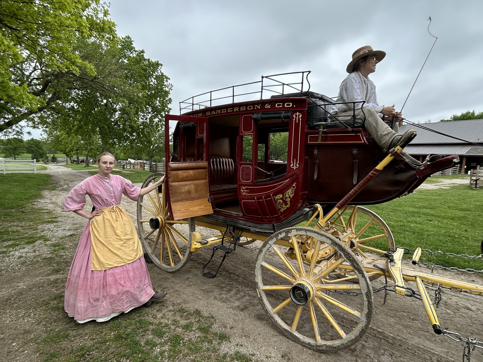
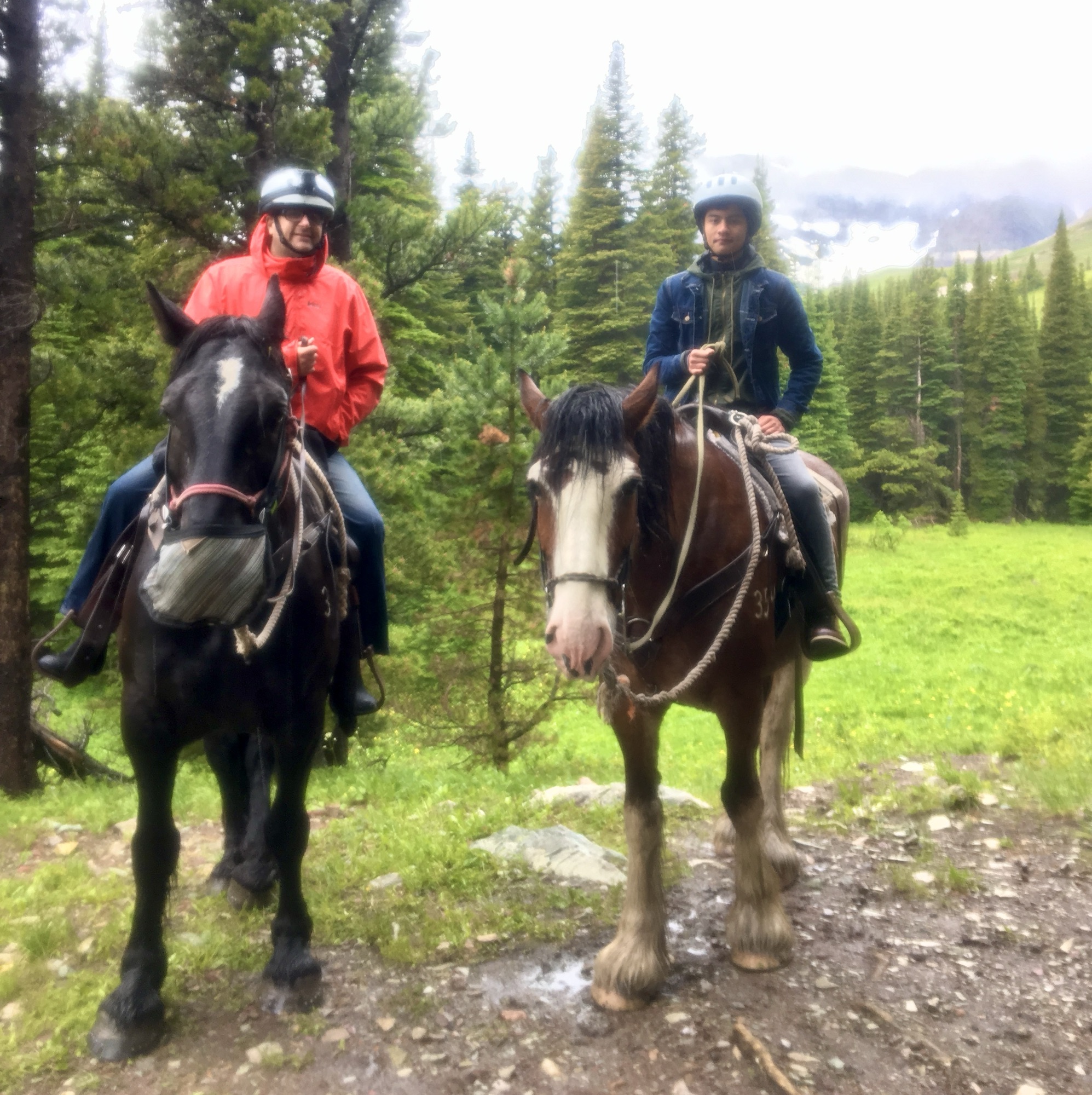
Kansas does not deserve the short shrift it often gets. At the state-managed Mahaffie Stagecoach Stop and Farm, for $7 I rode in the Santa Fe Trail stagecoach above, ate a quick bite as the passengers did in the original house, dodged heritage chickens in the yard, saw a ‘prairie schooner’ in the barn, carefully watched a blacksmith demonstration, and learned how differently vintage baseball was played in 1860. Living history is so much better than a regular museum, although they have one of those here too. The staff is bright and answered all my dumb questions quickly and cheerfully. This is my favorite trail stop.
Turns out that John Brown’s half sister lived here and insisted on strident ‘free state’ politics, doubtless supporting the Underground Railroad. John Brown freed slaves from Missouri, and one of his sons was killed fighting ‘border ruffians’ in front of his half-sister’s cabin nearby. Bushwhackers from Missouri frequently crossed the river to try to rig the election in favor of slavery, but they were fought by local Jayhawkers. Around 100 people were killed in the violent fighting known as Bleeding Kansas that is considered a prelude to the Civil War. Kansans’ staunch and courageous support for freedom was the hope of the nation, at a dark time in our history.
The greater area is also the starting point for basically all the trails going west, including Lewis & Clark, the Pioneer Trails and the Pony Express, all of which have museums nearby. And the first documented Civil War combat by African American Union soldiers—the 1st Kansas Colored Volunteers—occurred at Island Mound (YouTube) in Missouri, although not the first regiment. Oh, and Amelia Earhart’s birthplace, the Negro Baseball League and other interesting sites are also part of the NHA, along with official NPS sites like Fort Scott, Fort Larned and Brown v Board. So, let’s give Kansas some overdue credit.
Xochicalco

If you were disappointed by not being able to climb the 3 pyramids at Teotihuacán, then you will love climbing around here. This massive temple complex on a hill south of Mexico City may have been built as a successor to the more famous site north, as it has similar art. It also suffered a similar fate, as it was burned around 900. When you work your way around to the top of the Great Pyramid above, there are various animal symbols, a large plaza with baths, and even an observatory. Before telescopes, measurements and observations were taken through a tube in the ceiling by recording where the light shone on different days of the year. Be sure to get a good look at the temple of the feathered serpents. The head priest had a residence above the great temple, and the views of the valley are magnificent! The whole drive from Puebla was enjoyable, as I skirted around past the smoking volcano Popocatépetl.
South Dakota in Photos
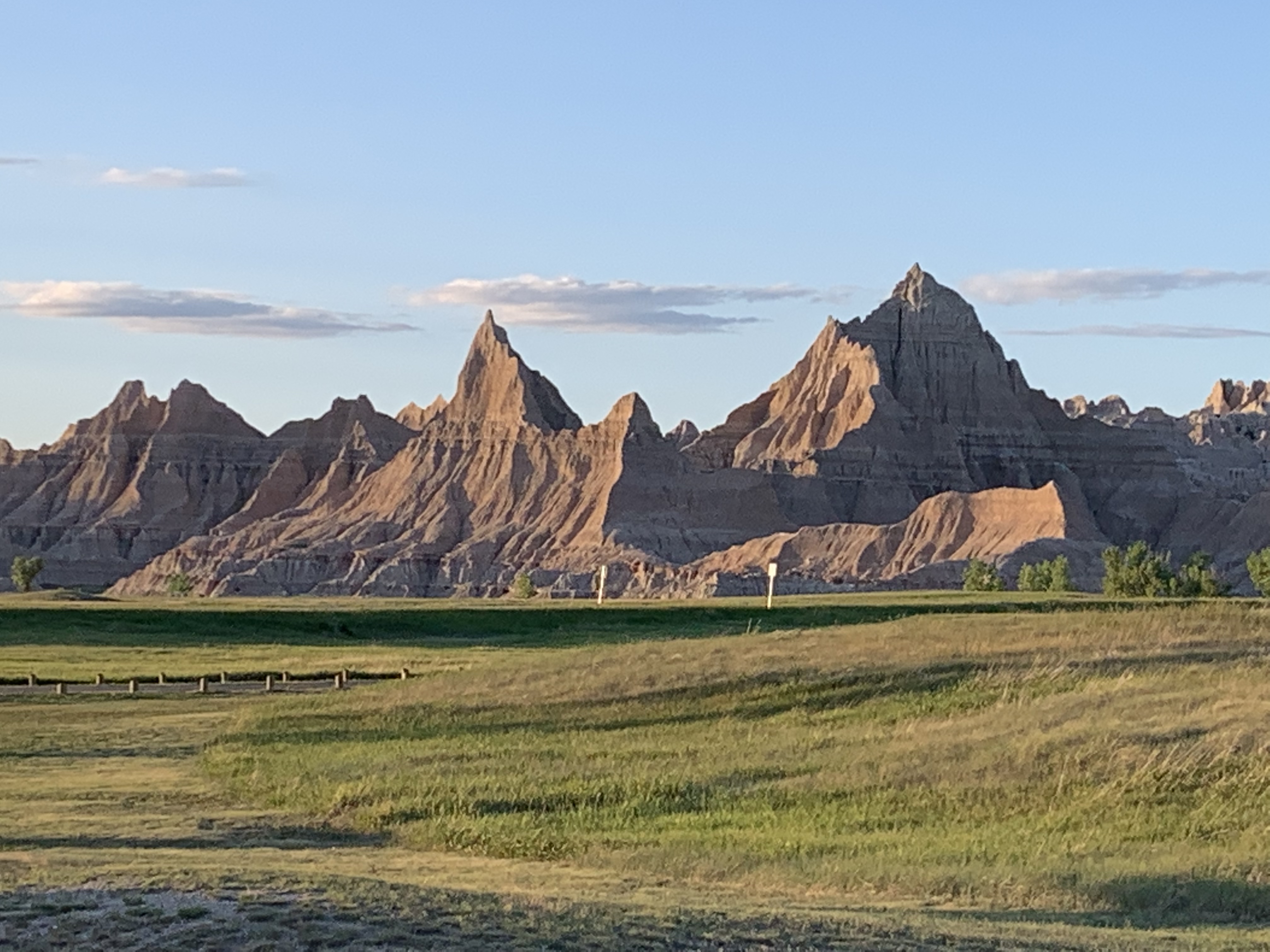


Quick bonus post to celebrate completing all the parks, trails, et cetera in South Dakota. The photos above are from the Badlands, Jewel & Wind Caves, Minuteman Missile and Mount Rushmore. The Missouri NRR borders the state and includes Yankton’s Meridian Bridge, which is nice for walking or biking and has a good kayak launch nearby. Lewis & Clark stopped here too, and there are several sites on their trail where the Yankton tribe showed them around South Dakota.
Northern Rio Grande and Sangre de Cristo National Heritage Areas

Quick logistical update: until summer, Mondays are Mexican World Heritage Sites, Thursdays are eclectic, and Saturdays are bonus park photos. I took the photos above yesterday in New Mexico and Colorado.
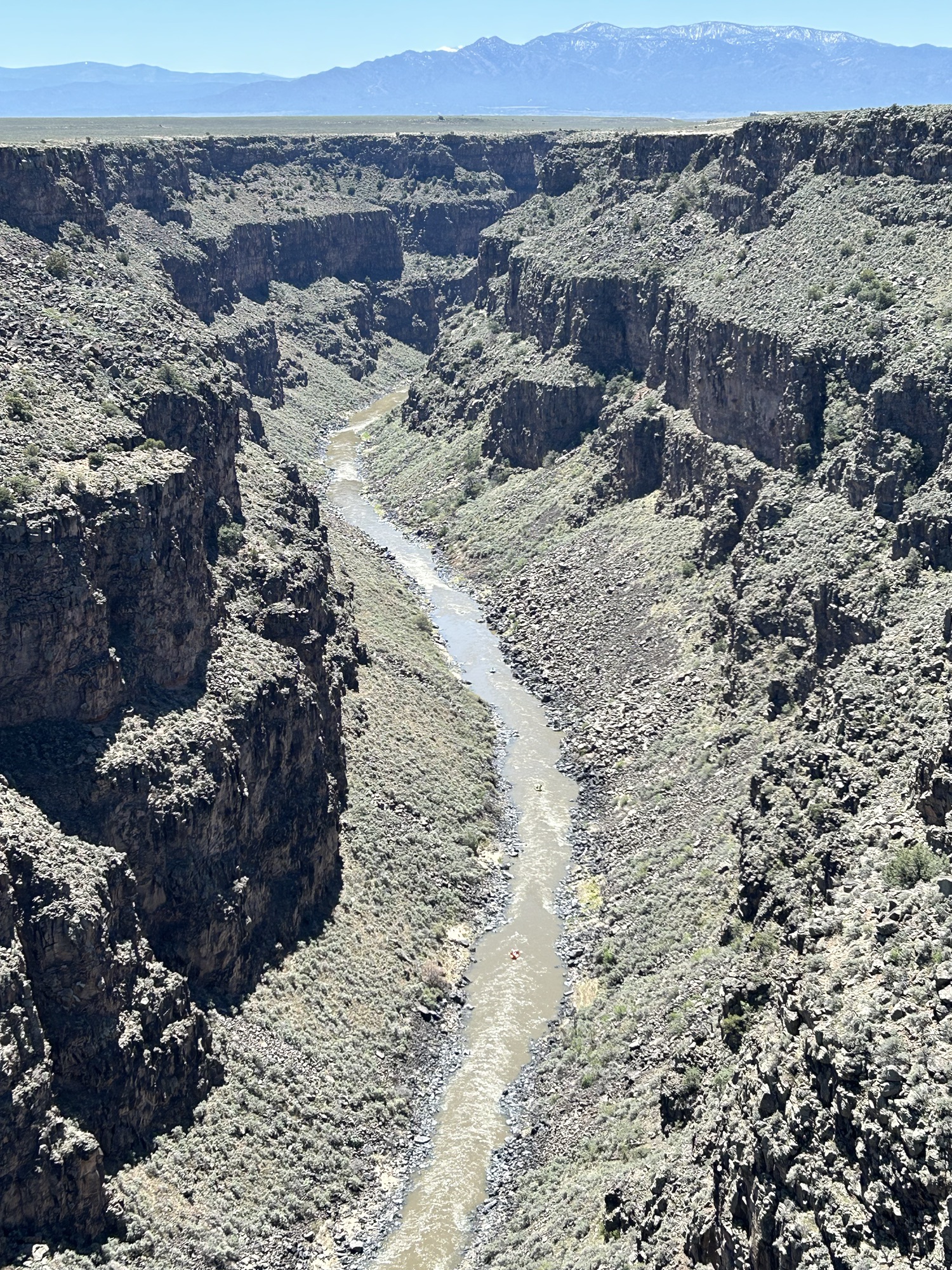
While technically in different regions, both National Heritage Areas are linked by the river, the mountains and our cultural heritage. The Rio Grande begins in the San Juan Mountains in south central Colorado and flows east through the San Luis Valley where it turns south into New Mexico. The scenic north section is called the Río Grande del Norte to distinguish it from the southern section that defines the Texas-Mexico border. The river flows through the Rio Grande Gorge and is now popular for whitewater rafting (see three rafts above left). In the distance are the Sangre de Cristo Mountains (both photos).
Native Americans and Spanish explorers traveled up and down the river, settling on the fertile valleys. The native land was claimed by the Spanish, Mexicans, and Texans, and for a dozen years, the Río Grande del Norte defined the US-Mexico border in Colorado, before the US claimed the land all the way to California by treaty in 1848. In the Civil War, Texas secessionists battled Colorado volunteers at Glorietta Pass in New Mexico to decide the war in the southwest.
The Northern Río Grande National Heritage Area in New Mexico celebrates this magnificent natural scenery and the cultural heritage it guided. It also includes Taos Pueblo, wild & scenic rivers, historic trails, scenic byways, and several cliff dwellings. Much of the land is also a BLM managed National Monument. The area is both beautiful and fascinating, and I was not going to miss another chance to drive through on my way northeast.
The Sangre de Cristo Mountains tower over the east side of the Río Grande del Norte from east of Santa Fe NM up into Colorado past the Great Sand Dunes. Meaning ‘blood of Christ’ in Spanish, the name likely refers to the scarlet colors of the mountains at sunset. The helpful illustration (my favorite photo above right) is on the Stations of the Cross trail up to a church that overlooks the historic San Luis Valley.
The Sangre de Cristo National Heritage Area in New Mexico borders the Northern Rio Grande National Heritage Area in Colorado, and includes the Cumbres and Toltec Scenic Railroad featured in Indiana Jones and the Last Crusade, the Monte Vista National Wildlife Refuge famed for Sandhill Cranes in March, and Fort Garland, a fine restored Kit Carson fort with an interesting museum on Buffalo Soldiers—one turned out to have been a woman who served for years as a man undetected. The area is lovely and pastoral amid snow-capped mountains, with many other worthy attractions, but I’m on the road again.
Puebla
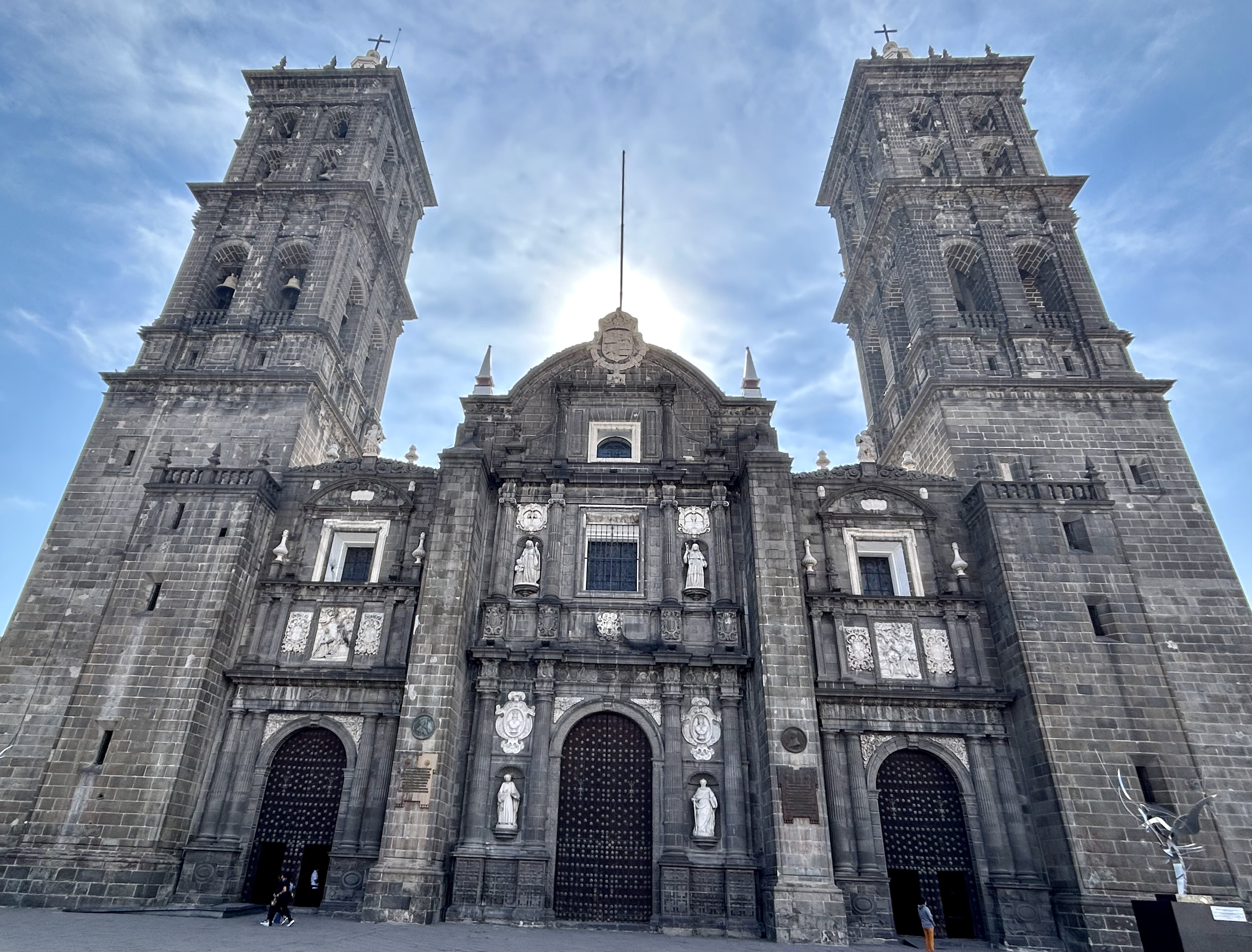
The city’s cathedral with its famed tall towers (above) is a primary reason UNESCO chose this city as a World Heritage Site. I spent a Sunday listening to bells, watching religious processions, and admiring many churches. But the whole historic district is marvelous! When Napoleon’s army tried to take the city in 1862, General Zaragoza defeated the French troops, earning recognition in the city’s official full name Heroica Puebla de Zaragoza. Of course, you already know about that victory, since we celebrate its anniversary on Cinco de Mayo.
While a pueblo is a town, Puebla refers to the Spanish settlers who founded the city between the port of Veracruz and Mexico City. The name comes from poblar (populate), so both people and peppers from Puebla are known as poblanos. Be sure to enjoy the poblano mole along with some local hard apple cider and other delicacies. The Ampara Museum is excellent, with a photo timeline showing civilization’s achievements by continent, beautiful artifacts, including a colorful Quetzal mural, rare and exquisite items from Teotihuacán, and a myriad collection illustrating the vibrant history of pre-colonial Mexico. There’s also a bullet-ridden house turned Museum of the Revolution after a 1910 dictatorial police raid. The zócalo, the green central square park next to the cathedral, is a perfect place to sit amidst the bustle and just soak up the atmosphere.
Biospheres of the Rocky Mountains
Biospheres are important ecological areas around the globe for protecting species diversity and for learning how to best sustain development ecologically, economically and socially. Science and solutions learned in each area are shared globally through the United Nations, and this is particularly important now that we face a global climate crisis. UNESCO currently recognizes three biospheres in the Rocky Mountain Region, and up to 2017, there were five more described below.
The Rocky Mountain Biosphere in Colorado roughly encompasses Rocky Mountain National Park and some of the Rocky Mountain Wilderness to the north. Some of the charismatic species in the biosphere are Bighorn Sheep, Elk, Mountain Lions, Pika and Snowshoe Hare. Scientists have studied species that have been wiped out of the area, like the Grizzly, Gray Wolf and Bison, as well as species that have moved in, like Moose. The exceptionally high altitudes define unique ecosystems of global importance.
The Crown of the Continent Biosphere in Montana includes Glacier National Park (see photo of author & son above). (Perhaps to de-emphasize the shrinking glacier problem, the Biosphere dropped the name “Glacier” in 2017). The biosphere is home to rare charismatic species like Grizzly Bears, Lynx and Wolverines. Over 100 years of scientific data on wildfires, snowpack, species populations, and more have been collected and shared from this park and its sister park Waterton Glacier in Canada. Like Rocky Mountain, the biospheres here cover the Continental Divide, which defines the direction of rivers across the US to the Atlantic & Pacific, but from here rivers also flow north to the Arctic, making these biospheres of particularly important for studying migrating species.
Yellowstone-Grand Teton Biosphere in Wyoming obviously includes Yellowstone and Grand Teton National Parks. One of the most intact predator-prey-scavenger biospheres on earth, with large herds of Elk and Bison, Grizzly Bears, Cutthroat Trout and Bald Eagles, and unrestricted rivers, this is an exceptionally important global biosphere.
Unfortunately, in 2017 the Trump Administration canceled 5 other biospheres in the Rocky Mountain Region. Apparently, the Israelis were upset that Palestinians were allowed to participate in UNESCO and used the place name “Palestine” in the name of a joint heritage site, so the US ended over forty years of scientific cooperation and research sharing with the world and removed many US biospheres from the global program.
The programs canceled in 2017 included three in Colorado: Central Plains Biosphere in the northeast, Fraser Biosphere in central, and Niwot Ridge Biosphere in the north. The Central Plains was particularly valuable in the study of short grass prairie ecosystems. Fraser was important in studying the interaction of forests, rivers and climate. Niwot Ridge contributed important research into alpine tundra ecosystems, glaciers, high altitude plants and climate change.
In Montana, the Coram Biosphere, west of Glacier NP ended in 2017. Coram was important in the study of forest regeneration and forest management. And in Utah, the Desert Biosphere, near Great Basin also ended in 2017. Desert, begun by President Hoover, contributed to our understanding of scrublands and pasturelands in hot and dry areas.
I’ve traveled in, through or next to all five canceled Rocky Mountain biospheres in my electric car, and they’re also uniquely beautiful places. But biospheres aren’t primarily meant for tourists, they’re meant for nature and for scientists. While some research continues at many of these sites, the international scientific and policy management cooperation was cut off. Especially facing a global climate crisis, we need to be actively cooperating to find global solutions to our ecological threats. Also, it seems bizarre to remove our own natural scientific research areas from participation in international science, due to deep-rooted political feuds in the Mideast. I hope these irrational mistaken biosphere withdrawals can be reversed by the current or future administrations, so that the global learning can continue.
Monarch Butterfly Biosphere Reserve
Butterflies are free. Monarchs may arrive at their winter home late, be choosy about where to land, and may leave early. At around 10,000 feet, the dormant volcanic peaks are covered in trees and flowers, with the specific temperatures the Monarchs need. Despite the distance and dangers, the fragile butterflies still manage to fly from Canada to Mexico every year in an extraordinary migration, one of the coolest natural events on earth.
Everyone loves the monarchs, and between the states of Mexico and Michoacán the reserve is both a UNESCO Biosphere and a World Heritage Site. During the November to March season, crowds of locals take bus day trips to see them fly, cluster, feed, mate and fly again. Since the flighty monarchs are unpredictable, day trips can visit their chosen forest at the best times. Overseas visitors often stay for a few days in lovely spots—like Cerro Pelón B&B run by a family of original butterfly rangers—to enjoy the picturesque villages and relaxing environment while recovering from high altitude hiking, as I did.
Humans can impact these glorious butterflies in many ways, both positively and negatively, and we need to be much smarter about making small changes that can help: reduce pesticides, grow butterfly friendly plants and drive slower when butterflies are present. But also, we need to make big, global changes to reduce our carbon emissions, so that this species can survive.
Which brings me to an Earth Day question. Is it worth flying and driving here to see the butterflies, knowing that your carbon pollution will contribute to their extinction? Better to drive an electric car.
Biospheres of the Southwest

This is a photo of a photo of a Texas Horned Lizard in the arid Chihuahuan Desert scrubland, from a roadside plaque near Las Cruces, New Mexico. The actual habitat is within the White Sands Missile Range and is off limits to the public. This UNESCO recognized special biosphere, Jornada—meaning day’s journey without water—, is open to scientific researchers from USDA, USFWS and NMSU, with limited school trips to the Chihuahuan Desert Nature Park in the southernmost corner. For many decades, the Department of Agriculture has been studying the climate here, gathering useful data about the fragile desert ecosystem. The Fish and Wildlife Service mostly focuses on the Bighorn Sheep and other species in the adjacent San Andres Mountains. New Mexico State University organizes research efforts and assists student scientists.
While you can’t visit the Jornada biosphere or disturb the wildlife, these scientific research zones are extremely important for understanding global climate change and the ecosystems that support unique species. But the southwest region has two internationally recognized biospheres that you can visit: Big Bend and Big Thicket. Big Bend, like Jornada, is part of the Chihuahua Desert, and it also includes a biodiverse riverine ecosystem. Big Thicket is one of the most biodiverse places in the US, where the bayous, leafy forests, pine forests, plains and sand hills intersect and provide habitat for thousands of species. While these areas provide enjoyable excursions for Americans, they are also important beyond our borders. Scientists from all over the world actively support protecting and studying these areas to ensure the survival of species globally.
Monasteries on the slopes of Popocatépetl

The volcano Popocatépetl was active, unleashing a huge cloud of smoke and ash, so the view of that Biosphere was not clear. I kept my distance. In the 16th century, the Franciscans built massive fortified monasteries below the volcanoes, and now 14 are recognized as a World Heritage Site. This one, named San Miguel Arcángel, is in the center of the small city of Huejotzingo, about 45 minutes from Puebla. This area is famous for carnival festivals, celebrating various conflicts and stories from before the Spanish arrived through the French invasion in the 18th century.
One use of the monasteries was for defense, and some played important roles in battles. This large monastery is an oasis behind high thick crenelated walls, enclosing an open plaza with beautiful old trees and behind more walls, a couple of lovely cloisters with fruit trees (above). There are renovations underway, due to seismic activity, but much can still be seen inside on a 75 peso ($4.50) tour. Just off the kitchen, there is a macabre holy relic display of skeletal, partly mummified remains in glass cases. Sundays the museum closes to accommodate services.
