The park service commemorates six parks for Teddy Roosevelt, from his childhood home in NYC, to the ranch in North Dakota where he mourned, to his family home on Oyster Bay, to the room where he was sworn in after an assassination, to the DC island that celebrates his legacy and to the monument that rightly places him among our greatest presidents. The carbon crisis threatens to end the environment Teddy Roosevelt saved for us, so he would want us to switch to electric vehicles to enjoy all his parks, as I did.
I like Mount Rushmore, but it’s in the wrong place.…
At least a dozen current National Parks began with Teddy Roosevelt protecting their land, besides his namesake park above. His friendship with John Muir inspired our entire national park system. We owe a debt that we can only repay by continuing his legacy of preservation for the future.
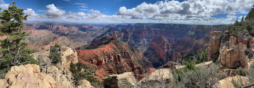
As President, Teddy Roosevelt protected 230 million acres for us in 20+ states, including national forests, rivers, preserves and more, such as around the beautiful San Luis Valley. He’s directly responsible for all the units listed below, plus others, as well as for signing the Antiquities Act by which presidents still designate national monuments.
“The civilized people of today look back with horror at their medieval ancestors who wantonly destroyed great works of art, or sat by slothfully by while they were destroyed. We have passed that age, but we are, as a whole, still in that low state of civilization where we do not understand that it is also vandalism wantonly to destroy or to permit the destruction of what is beautiful in nature – whether it be a cliff, a forest, or a species of mammal or bird. Here in the United States we turn our rivers and streams into sewers and dumping-grounds. We pollute the air, we destroy forests and exterminate fishes, birds and mammals – not to speak of vulgarizing charming landscapes with hideous advertisements. But at last it looks as if our people were awakening. Above all we should realize that the effort toward this end is essentially a democratic movement! Now there is a considerable body of opinion in favor of our keeping for our children’s children, as a priceless heritage, all the delicate beauty and all the burly majesty of the mightier forms of wildlife. Surely our people do not understand, even yet, the rich heritage that is theirs!”
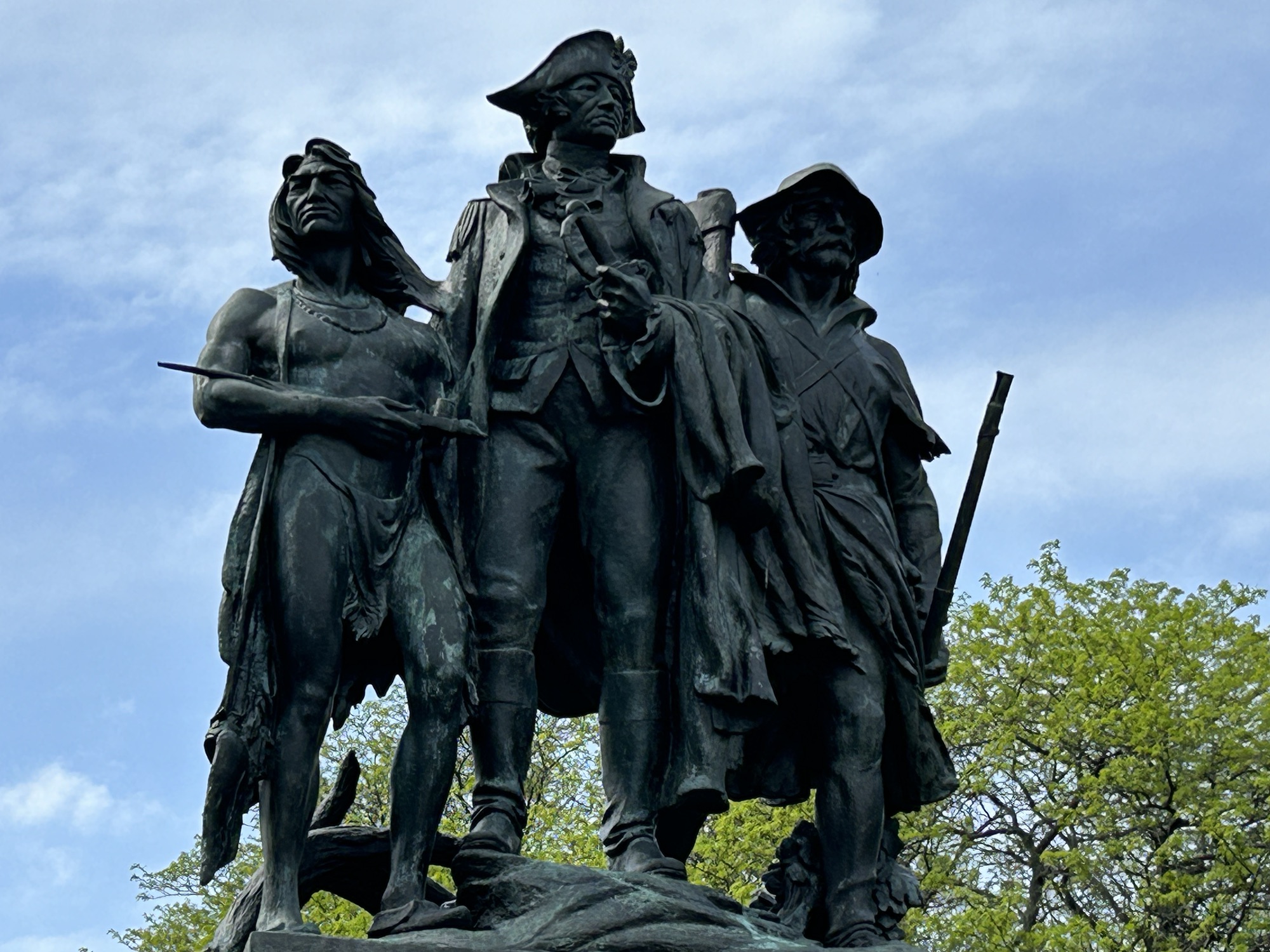
The much disputed western frontier was once here in Ohio, where the British Fort Miamis guarded the crossing point and last navigable stretch of the Maumee River to Lake Erie, backed by their confederation of Native American allies. George Washington sent General Wayne (above center) here after his previous general had been defeated. In 1794, Wayne’s troops met over 1,000 native warriors in battle, and prevailed, resulting in much native land being ceded to the US.
In 1811, Indiana Governor William Henry Harrison provoked the natives into fighting again. When the War of 1812 broke out, the British reforged their native alliances and used their naval power to reoccupy Fort Miamis. Now General Harrison—later the 9th President—built a new fort on the other side of the Maumee River and held it against attack. The fighting then moved north, where Harrison’s troops killed the Shawnee leader Tecumseh and defeated the British on the Canadian side of Lake Erie, ending both the British occupation and native land ownership in most of the northwest.
The site is affiliated with the NPS and managed by Toledo. Due to an early mistaken account of where the battle occurred, the statue above is neither on nor facing the battlefield, which is behind them over a bike bridge in the woods. There are plenty of bike trails connecting different riverside parks, and there’s an Audubon island with heron in the middle of the river. The earthworks of Fort Miamis are still clearly visible overlooking the Maumee. History and nature await us.
While not the largest rock formation in the west, Chimney Rock above, was the first exceptional one seen by the pioneers on their journey across the wide open prairie, so many pioneers elaborately described it in their journals. Judging by the old photos, it has lost some of its point, but it still towers over the landscape. Chimney Rock also made a clear landmark for the prairie schooners navigating on the Pioneer Trails from the Platte River to the nearby pass at Scotts Bluff. The site is affiliated with the NPS, but it is managed by the Nebraska State Historical Society.
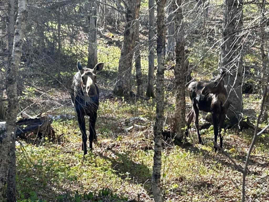
This is now my favorite park for wildlife. I was lucky to get a photo of this moose and her calf on the 1 mile Nature Trail in Windigo just before my boat left. Despite seeing loons, mergansers, swans, geese, and even a bushy tailed fox parading near my shelter on Washington Creek, I had neglected to take any decent wildlife photos, so until these two approached me, all I had was one photo of two ducks: a paradox.
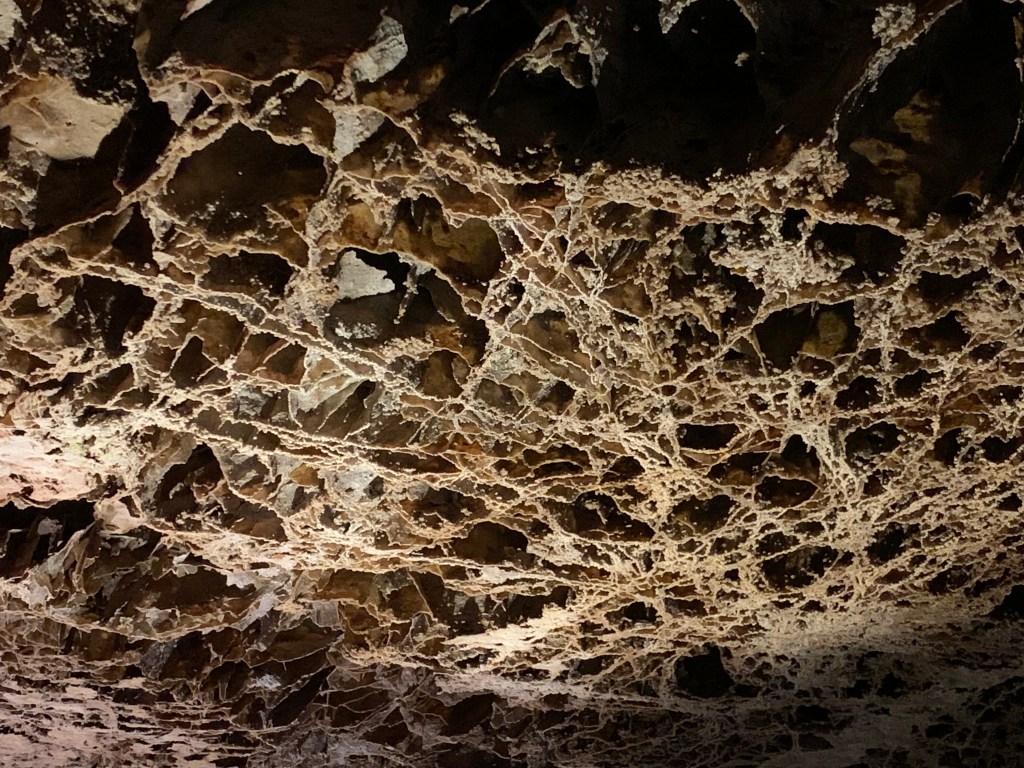
I hiked a dozen miles and enjoyed the pitcher plants and boardwalks through the swampy areas and the mossy boulders on the north shore. The island is larger than I imagined, so be sure to download the park map in advance and charge your phone. This Biosphere is one of the least visited National Parks but most re-visited. Many folks hike the length over several days, and early in the season there were many volunteers hiking off-trail doing scientific research on wolf-moose predator-prey. A few were carrying a canoe for inland lakes. It’s an idyllic place, with hours of silence and solitude, a wonderful trip into the wilderness.
Isle Royale is in Lake Superior, and the shortest ferry ride is a couple hours from Minnesota to Windigo. The island is part of Michigan, and there are also ferries from the Keweenaw Peninsula in Upper Michigan to Rock Harbor. Most visitors are experienced hikers who backpack to their campgrounds, and it’s 40 miles between Windigo and Rock Harbor. Some arrive by private boat, and several campgrounds have docks. Lodgings are limited to Rock Harbor and a couple cabins in Windigo, and rooms are both very expensive and typically sold out many months in advance. The season roughly runs from early June to early September, so it’s a good idea to plan your trip a year in advance.
To visit 16 of Mexico’s World Heritage Sites in a zero emission vehicle, I drove round trip from Texas to Mexico City, through 13 Mexican states, and, while a bit bumpy, I enjoyed the trip very much. All my trip report links are at the end of this post.
If you read online comments in the US, you might get the idea that traveling in Mexico is impossible or foolhardy at best. Well, you can’t believe everything you read online (except this blog of course). Over the entire trip, I was only asked for one ‘bribe’ of $1, to park briefly in a student parking lot without a student id. The state police, national guard and military were all very professional and waved me through either without comment or after glancing at my car permit. While I saw crime on the TV news in Mexico, I observed none.
After driving in Mexico, I finally understand driving in Texas. Instead of overpasses, underpasses and clover leafs, just use ‘retornos’ or U-turns. Folks leave the nice highways, well, they’re on their own, immediately. Want to slow traffic, without relying on folks to obey signs? Just use lots of speed-bumps or topes. Although, there are even more techniques to learn. First, always be alert. Pothole! Second, drive halfway in the breakdown lane to avoid head-on collisions with oncoming passing traffic. Third, always be alert, seriously, you need to pay attention and think while driving. Drivers are generally nice, but get out of the way of speed demons and quickly pass vehicles that wouldn’t be allowed on the roads in the US.
All Mexico is divided into three parts. Mexico City is best navigated by metro, with its one way streets, traffic and lack of parking. Traffic can be stultifying. Of course, electric cars are exempt from the Hoy No Circula—‘no driving today’—restrictions, which otherwise limit your access to the city according to the last character of your license plate. Circumnavigating the city on the ring road requires tolls: take your ticket and be prepared to pay cash (although a few places take credit cards). Remember the metro is 5 pesos or ~30 cents.
The mid-sized cities and tourist areas outside Mexico City are still crowded, but passable by private car. I was frequently fortunate to find parking very near World Heritage Sites in mid-sized city centers. Of course, the more touristy, the more likely that the roads are cobblestone. San Miguel de Allende may be magical, but I scraped the bottom of my car several times on medieval stones. Better to park outside the historic zones and walk. Still, driving your own car gets you to places that are otherwise challenging to reach.
And then there are the mountains and remote villages. Ah, lovely! But no signal to navigate. I got lost three times near the butterfly reserve. Once, my navigation asked me to drive between two trees on each side of a hiking trail. But I must admit, some of the most beautiful places in Mexico are just off the grid. Horse-driven ploughs, indigenous costumes, and forest-covered volcanoes await. Long drives are best on toll roads with frequent $5 to $15 tolls.
On this trip, I used Superchargers exclusively, and I only saw half a dozen Teslas in Mexico, including my own, mostly at chargers. Unlike the US, there isn’t a government subsidy for most electric cars, so my car was not just unusual, but uneconomical in the short run. I got few comments or looks, and the valet parking attendants had never driven one before (and didn’t like them). There are a few other electric models that I saw on TV, which we don’t have in the US, and I spotted a few of those in Mexico. But overall, electric cars are an elite affair, with parking and charging in the most expensive malls in expensive neighborhoods. I found the supercharger network from McAllen to Puebla accessible and without gaps, although it’s better to charge whenever you can, just in case you need a lot of air conditioning or have to detour.
While Mexico might seem intimidating or unrefined, the truth is that it’s worth the trouble. There are European-style cathedrals, ancient pyramids (photo from Anthropology Museum), glorious art, scrumptious food, and natural wonders that are well worth driving a couple days with the trucks on the long highways. An unexpected side benefit to driving was passing through three UNESCO Biospheres along the way: Cumbres de Monterrey, La Primavera near Tequila, and Los Volcanes near Mt Popocatépetl. I reviewed the State Department warnings and used them to plan my trip, but, again, the best way to avoid crime is to avoid drugs and be careful. Americans should take advantage of the wonderful travel opportunities just south of our border, and I’m not talking about all-you-can-whatever resorts that you fly into. See the real Mexico, and drive electric!
Technically, the name of this UNESCO World Heritage Site is Agave Landscape and Ancient Industrial Facilities of Tequila. But that’s a mouthful. For at least 2,000 years, folks around here have been making pulque, a milky agave wine. A wealthy Spanish aristocrat, working around a royal ban on new vineyards, started distilling blue agave, inventing a new drink named after the town of Tequila in Jalisco state. Above are Tres Mujeres oak barrels aging tequila for years, to the sound of classical music, which is thought to improve the taste.
But wait, trendy folks claim they don’t like tequila and only drink mezcal, which is silly since tequila is a type of mezcal. Mezcal is a very broad category of alcohol, including home brews, stuff sold in plastic containers out of the trunks of cars, and a few quality refined spirits, like tequila. Some mezcals use extra wood burning to add more smoke flavor, but good tequila just uses the cooked agave fruit and the smokiness from the barrel. Some tequilas add food coloring, but good tequilas similarly gain their color naturally.
Another misconception is that like champagne, all tequila must be made near Tequila in Jalisco. That’s not true. Tequila can be made anywhere in the state of Jalisco and also in designated areas of half a dozen other states in Mexico. We did a tequila tasting many years ago out of Puerta Vallarta, and it was as authentic and delicious as the ones near Tequila. Even the heritage site covers several different towns west of Guadalajara.
Between Tequila and Guadalajara is a UNESCO Biosphere, La Primavera or ‘springtime’, which includes a pine-oak forest, springs, orchids, birds and more, and it’s a popular recreation area. Tequila is my last stop in Mexico for a while—quite an enjoyable one—, so now Mondays switch back to US park units, affiliates, trails and heritage areas. Thanks for reading!
Visit several World Heritage Sites in Mexico and Canada—Done, will post by year end.
Complete the North Atlantic & Midwest regions—1/2 done, in progress.
While I haven’t posted all my visits yet, I’m officially up to 380 out of 429 park sites, plus most of the heritage areas, trails & about 1/2 the affiliates. Next Monday will be the end of my Mexican World Heritage Site roadtrip, so after that Mondays will switch back to US parks, including affiliates, trails and heritage areas. Thursdays will continue to be eclectic, with various regional summaries, logistics and opinions. Look for some new zero carbon vehicle announcements. I’m cutting back on the Saturday state photo posts to every other week for the rest of the year. Turns out there are a limited number of states—who knew?—including some I haven’t completed yet. Thanks for reading!
Originally designed to be a hospital, like Les Invalides in Paris, and named after the bishop, today the World Heritage Site in the historic heart of Guadalajara is a museum, with modern art outside and exceptional murals by Orozco inside. The central masterpiece on the ceiling of the rotunda is ‘The Man of Fire’, a modern version of the myth of Prometheus (in photo on right). I had seen Orozco’s earlier version in the Pomona dining hall in California, considered “the greatest painting in America” by Jackson Pollack. Orozco lost his left hand making fireworks at 21, and he was fascinated by the story of a man who risked his life and suffered to expand human knowledge and civilization, only to be punished by the Gods. He felt the myth was an allegory for artists, explorers and reformers who were punished by conservatives for their efforts to bring enlightened change to the people. Every alcove and wall tells a story of both progress and betrayal, of historic accomplishments and dark consequences.
Prometheus stole fire from the Gods, but today we struggle with the consequences of burning carbon. Fossil fuels helped us achieve great things, but there are always consequences. Struck by the inescapable conclusions of the art here, we see that conflict over ‘progress’ often results in suffering, especially among the poor. Murals require us to step back, to try to see the bigger picture. We can build hospitals, and we can also destroy whole cultures. We can choose sustainable fuels, or we can let powerful men perpetuate destructive fuels. We may believe ourselves invincible and deserving of the powers of the Gods, but our actions come with destructive consequences that we must try to see, understand and prevent. We must give up fossil fuels, or our world will burn.