The full name of the world heritage site is ‘Islands and Protected Areas of the Gulf of California’, and the UNESCO site covers much of the old Sea of Cortez which Jacques Cousteau once called ‘the world’s aquarium’. Many of the mountainous islands in the gulf are home to unique species—including a rattle-less rattlesnake—and are protected from development, including the island of Espíritu Santo near La Paz. Last month I visited many of the gulf’s bays on the Baja peninsula, including Bahías de Los Ángeles, Concepción, Loreto and La Paz. In the Loreto national marine park, I saw bottlenose dolphin and fin, humpback and blue whales, including those blues in the videos below.
Earlier this month I visited Sierra de San Francisco in central Baja Mexico to see the prehistoric rock paintings which are a world heritage site. They are spread out over a vast, mountainous area and just to see a few requires a 5 day group trek on burro to reach several different caves. One closer site, El Ratón—called ‘the rat’ but meant to be a cougar—, is a short hike off a long, well-paved road. Unfortunately, it’s not the best of the rock paintings, as the alcove is fairly open and the art has faded. The small free museum in San Ignacio is overseen by an official who provides required passes out of his office next door, when he’s there. Hiring a local guide is required along with paying various government fees. For a solo Baja driver, it’s best to visit El Ratón on the way back north, as the cave road is north of San Ignacio, where you must pay first. Group tours can be reserved from San Ignacio, Loreto, and Guerrero Negro. Frankly, I recommend just going to the museum and making a donation. There you can see some good photographs of several of the best examples, along with a large reproduction, above, to give you a sense of how they are displayed on alcoves and in caves. Traveling through Baja, you see reproductions in many public spaces, proudly reflecting the internationally renowned 2000 year old cave art, the cultural remnants of the Cochimí people.
Earlier this month, I visited El Pinacate y Gran Desierto de Altar [literally ‘the stink beetle and the great high desert’]. It’s a UNESCO Biosphere and World Heritage Site in Sonora Mexico, and it’s a sister park to Organ Pipe Cactus NM across the border in Arizona. A dozen pronghorn scampered through the various cactus, but unfortunately the border wall prevents many species from moving freely in their natural habitat. The main attraction is ten large volcanic craters, including the deep, symmetrical Elegante below. The landscape is extraordinary and otherworldly, with long black lava walls, cinder cones, sand dunes, various cacti, bushes, shrubs and wildflowers. There is enough rainfall to support birds, reptiles and wildlife like big horn sheep. Some folks camp overnight to experience the vast dark skies, far from large human settlements.
A 2018 movie called Sonora was filmed here, and the movie describes the desert as both the middle of nowhere and ‘the devil’s highway’. A few years ago some criminals moved into the area, but they are gone now. The roads are severely washboarded, sandy and sometimes are blocked by local landholders due to disputes over compensation, so I hired a driver, a van and a guide. There are no facilities to speak of, so you need to bring whatever you need in and pack everything out. From the supercharger in Gila Bend, it’s more than a full charge round trip to Puerto Peñasco or Rocky Point where guided tours depart, so I charged at my hotel on the Playa Bonita. The local economy is still recovering from various border shutdowns and Covid, but the onsite park museum is expected to reopen soon, which will bring more visitors. But for my visit, I was happy to have the whole park to myself.
The Salmon River flows into the Pacific just out of sight between the headland and the beach above. The trail up here to the lower viewpoint starts at the boat launch, climbs through a lovely mossy old growth grove and crosses a few small bridges—the cascades were hidden in the brush—before reaching the meadow where a rare flower and butterfly live. There’s an upper viewpoint some 700 feet further up the hill, but I figured the closer view was better.
This UNESCO Biosphere is mostly on Nature Conservancy land, thanks to concerned citizens who rallied to protect it. Definitely needed the birdsong app: white-crowned sparrow, golden-crowned kinglet, chestnut-backed chickadee, pacific wren and a brown creeper, not to mention the usual coastal waterfowl and some raptor I couldn’t identify. Lovely spot on the Oregon coast with about a dozen other hikers on the trail on a beautiful day last fall.
This large UNESCO biosphere near Edmonton Alberta includes Elk Island National Park, which has hundreds of plains and wood bison. But Elk Island is fenced, so, as important as that park is for restoring the bison population, I came to see beaver. And on the Beaver Hills Biodiversity Trail, I saw several large beaver dens, like the one above.
Beaver are quite destructive, and their homes are surrounded by felled and drowned trees and pointy stumps. But they also create year round dens and dams with ponds and small lakes for many other species. Besides the many waterfowl, blue dragonflies, and chattery squirrels, I saw a magnificent golden eagle circle above the pond. And of course, I saw five or six beaver, swimming far from their dens, playing and occasionally climbing on branches to dry off, scratch or hang out.
When humans create zoos, safari parks or even national parks with fences, it’s not right to call the enclosed animals ‘wild’. Some may have been born wild, but as long as they’re locked up, they’re no longer wild animals. Humans make the rules in those spaces, so, no matter how we try to copy nature, the spaces are artificial. But when beaver fell trees, build dams and create lakes, they make the rules. And the species gather there naturally. Beaver Hills is a natural area, filled with wild animals, and it is delightful to pause here and take in the peaceful balance of life.
I saw ducks and geese in the thousands, a flock of whooping cranes, a pair of sharp-tailed grouse, and many other birds, but they kept their distance from me. Saskatchewan has many lakes, and occasionally one will be full of birds. I also saw a young moose walking near the road, and there were bison behind fences. Since I was there during harvest, I could see the giant combines gathering grain. The self-guided driving tour gives several suggestions for exploring the area, which is mostly farms and First Nation communities. I believe there’s a visitor center opening soon.
The lake is at the center of a UNESCO Biosphere Reserve, but there’s also a popular state park camping and recreation area. So there are RVs, cabins, a beach below with a playground, mini golf, a golf course, a boat launch and even a few JetSkis, which hardly seem compatible with an internationally important bird refuge. Humans have trouble sharing our world with all the other species.
The view above of Clear Lake from the wishing well is beautiful. The Canadian biosphere includes Riding Mountain National Park and environs, including many ranches, homes and towns that proudly support the local species and clean environment around them.
I enjoyed a few hikes in the park, including a lovely marsh with floating boardwalks and over a dozen bird species, like swamp sparrow, black billed magpie and yellow-rumped warbler. (Love that birdsong app!)
Another hike took me to a lake near Grey Owl’s cabin, before he moved to Prince Albert National Park in Saskatchewan. He was an Englishman who reimagined himself as part Native American and who spent his life advocating for wilderness conservation, especially the beaver. Interesting stories about him. Unfortunately, I didn’t see any beaver, but I did see the moose below.
A series of locks allow small boats through Jones Falls below on the lovely historic river and canal connecting Ottawa to Kingston in Canada. In season from mid-May to mid-October, the boats tie up on the dock to the right and wait their turn, perhaps staying or getting something to eat at the 1870s lakeside Hotel Kenney. Chaffey’s Lock is another of the many pretty, historic locks, and it has a fancy hotel, a lock-master’s fort—in case the Americans try to invade by canal—, and a swing bridge that rotates on a wheel to let tall boats clear the lock.
The canal is recognized by UNESCO as a World Heritage Site. There are a couple dozen locks between Ottawa and Kingston Ontario built almost 200 years ago to facilitate trade and travel between the Great Lakes and the Atlantic Ocean. Today, giant cargo ships stick to the main St Lawrence Seaway, but that shift left a dozen or more adorable “timeless” little villages along the original canal route. Small boats still use this canal to avoid heavy barge traffic, dangerous currents and because it’s beautiful and fun. Much of the canal is short sections that connect a series of lakes, including Lake Rideau. If you visit the town of Westport, I recommend dinner at the atmospheric old Cove Inn, which often has live music.
Ignore the famed waterfalls and focus on Goat Island cliff in the middle. That wall is the Niagara Escarpment, caused by relatively hard rocks at the top holding the land underneath together, until it erodes away from the side. This two level land break—all erosion and not earthquake fault—is the key geologic feature to understanding the Great Lakes.
Much of the escarpment is in Canada, and even where it crosses the border to form Niagara Falls, it’s easier to see from the Canadian side as above. It runs along the south shore of Lake Ontario, across Niagara Falls (above) where it sets the level of Lake Erie, northwest through Ontario where it guides the Bruce Trail, up along the north shore of Lake Huron where it splits off Georgian Bay and shapes Lakes Huron and Michigan, along Michigan’s Upper Peninsula where it separates Lake Superior, and down the Door Peninsula past Green Bay in Wisconsin. After driving around the Great Lakes, it’s apparent how the water levels depend on the escarpment: Superior is the highest above both ends, Michigan and Huron are the same level in the middle, and shallow Erie is a little lower, held back at Niagara Falls, before that river drains into the lowest lake, Ontario.
UNESCO defines the Biosphere as the mostly forested area of Ontario between Niagara Falls and Tobermory on the tip of the Bruce Peninsula next to Georgian Bay, roughly 500 miles along the escarpment. The geologically interesting landscape holds great biodiversity in wetlands, coastline, deciduous & conifer forests, and rocky bluffs, perhaps the most in Canada. And there are many opportunities to explore, photograph wildlife, hike, drive or boat nearby. I hiked on the Cup & Saucer Trail on Manitoulin Island, the world’s largest freshwater island, when traveling around the Great Lakes. There, the escarpment is eroded on both sides, providing many views along its edge, including Lake Manitou below.
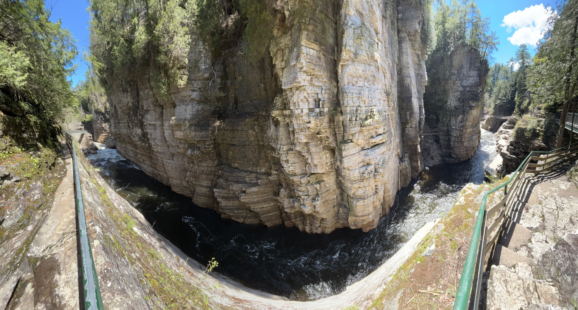
Much of upstate New York belongs to the Adirondacks, with old mountains, lakes, forests, wildlife and scenery. Two of the more famous tourist spots are the High Falls Gorge (above) and the Ausable Chasm (below), both on the Ausable River—from the French ‘au sable’ meaning ‘sandy’—which is fed from Lake Placid and flows down to Lake Champlain. Since they’re well developed old trails, walking along the secure walkways and overlooks costs about $20 each, but I think they’re still worth it, though neither is quite the scale I imagined for the ‘Grand Canyon of the East’.
Lake Champlain is part of the water route from New York City to Quebec, so several key battles were fought in the area, including at Saratoga and during the War of 1812. The British were winning in 1814, having sacked DC, but Thomas Macdonough won the Battle of Lake Champlain aboard his ship, the USS Saratoga, thwarting a British invasion down the Hudson in 1814.
This National Heritage Area preserves both history and beautiful nature, including Marsh-Billings-Rockefeller in Vermont. The Champlain-Adirondack Biosphere is also recognized by UNESCO for its forests, wetlands and mountains in both upstate NY and about 1/2 of Vermont. Unfortunately, the Trump administration ended the only other UNESCO Biosphere in the North Atlantic Region at New Hampshire’s Hubbard Brook hardwood forest research. Still, there are many other fascinating places to visit in this diverse heritage area, such as the Antique Boat Museum in Clayton New York on the St Lawrence River, as well as the scenic homelands of the Algonquin and Iroquois people near the Canadian border.