Between Montreal and Quebec City is the beginning of the St Lawrence Estuary, near the city of Trois-Rivières. (One of the dozen tributaries here has islands at its mouth, making it look like three rivers). The UNESCO Biosphere includes this large wetland lake and many islands in the seaway and tributaries, making it an excellent site for birds. Its great blue heron rookery is quite famous, but may be difficult to access. I chose to visit the Ecological Park of Anse du Port, because it has a very long boardwalk out through the wetland all the way to the lake, with a three story viewing platform to view container ships passing in the main channel. From the boardwalk, I saw several great blue heron, two beaver, a raccoon, a woodpecker, ducks (above), bittern, and a half dozen other types of birds. Binoculars or a telephoto lens camera would be helpful, but sometimes the birds come quite close.
Pennsylvania has eight National Heritage Areas, by far the most of any state, and I have visited them all by EV. Kudos to their politicians, but Pennsylvania does have many unique areas worth visiting.
The Delaware & Lehigh National Heritage Corridor includes the National Canal Museum with summer canal boat rides and different trails and bike paths along historic routes for coal and early American industry. The trail runs (with a few gaps) from the Lower Delaware River, through Allentown and will eventually connect with Wilkes Barre on the Susquehanna River.
The Journey Through Hallowed Ground NHA covers Civil War sites across four states, with Gettysburg being the star in Pennsylvania.
Lackawanna Valley NHA’s star is Steamtown above, but the area includes electric trolleys, as well as historic coal, iron and industrial sites.
The Oil Region NHA includes Drakes Well and other sites related to the birth of the modern petroleum industry in the Quaker State.
Fort Necessity and Friendship Hill are both in the Rivers of Steel NHA, but the historic focus is best seen by visiting sites like a blast furnace or a foundry & machine shop that explain how the steel industry began.
Schuylkill River Greenways NHA includes Hopewell Furnace, Independence NHP and Valley Forge NHP, but there are also over 100 miles of river to explore paddling, hiking or driving. (Say SKOO-kil meaning ‘hidden river’; so Schuylkill River is redundant.)
Susquehanna NHA focuses on the river valley and colonial York more-so than the Amish communities of Lancaster County, and there are many beautiful natural places to explore.
The Path of Progress National Heritage Tour Route is currently a bit DIY, but it includes Allegheny Portage, Fallingwater and Johnstown Flood sites along picturesque, winding historic roads.
There are five NHAs in the Rocky Mountain Region: three in Colorado, one in North Dakota and one in Utah. I’ve visited all of them (plus the Great Basin that extends into Utah), and I encourage you to visit too. As befits the region, they are areas of great natural beauty, but each differs distinctly.
Cache La Poudre(Buried Gunpowder) River National Heritage Area follows the river through Fort Collins, a fair sized city north of Denver. The headwaters of the river begin in Rocky Mountain National Park, outside the NHA, and the beautiful upper portion is a popular rafting Wild & Scenic River run by the Forest Service. I love the naturally-flowing sections of the river, which are remarkable, even in a state known for whitewater rafting. The NHA includes historic water works, irrigation canals, a bridge for sugar beet effluent, picnic areas, lakes & reservoirs, bluffs, wildlife areas and a whitewater practice area. The cooperative water district is considered a model for preserving early water rights, although it diverts water through tunnels that would otherwise flow west or north to drier states. Water policies need to be decided nationally, even if it means changing water rights established over 100 years ago. While I’m impressed with how industrious people have been making money with the river, the Climate Crisis is affecting the snow-pack, causing wildfires, and threatening species that depend on the river. So, I believe there’s still much work to be done.
Sangre de Cristo—Blood of Christ, referring to color of the mountains at sunset—National Heritage Area includes Great Sand Dunes National Park & Preserve (above) and many forests and wildlife areas in southern Colorado. The area figures often in the novels of Louis L’Amour, loved by my grandfather, and there are still stark stretches of remote beauty along the Old Spanish Trails below and among the towering mountains. This NHA borders the Northern Rio Grande NHA in New Mexico, and the headwaters of that river begin here. Some of the oldest settlements and churches in Colorado were built here by Spanish-speaking settlers, following the Rio Grande up from Santa Fe, as I did, enjoying the scenery.
I drove through South Park National Heritage Area looking for a scenic route from Florissant Fossil Beds to the Black Canyon of the Gunnison, and there are half a dozen scenic historic auto tours here, amidst many wildlife refuges, historic ranches, canyons and old mining outfits. I spent my time gawking at the peaks, vistas and fall colors, without taking photos. Colorado has that kind of indescribably rugged beauty that makes you want to change your life, sell your belongings and move into the mountains, although I admit I haven’t spent winter there.
The Northern Plains National Heritage Area in North Dakota is also ruggedly beautiful. I remember driving great distances to see Knife River Indian Villages NHS before it closed, and I stayed at several state parks to charge. Maybe half a dozen state parks are in the NHA, and they have good facilities, are uncrowded, and are in beautiful spots, often near lakes or rivers. Several of the state parks are stops on the Lewis & Clark NHT. The Native American tribes who assisted them on their journey were later described and painted by European artists and authors, fulfilling great curiosity across the Atlantic and inspiring many Europeans to immigrate to the New World. As with other NHAs, there is a unique sense of place, fleeting historic moments and cultural details that enrich the land with atmosphere, and of course, great natural beauty. But you have to drive, stop, pay attention, keep your eyes open, read, try to understand and make connections, or the whole country just appears to be empty space that you fly over, recklessly burning carbon.
The Mormon Pioneer National Heritage Area includes Bryce, Canyonlands, Capitol Reef, Cedar Breaks and Zion. But besides those geologic wonders, the idea is to encourage more travel on routes 89, 12 and 24. There’s a Scandinavian community around Ephraim in the pretty Sevier Valley on 89. There’s Grand Staircase-Escalante, Goblin Valley, outlaw hideouts, ghost towns, old theaters, and more. I’ve traveled through the NHA in every season taking different routes, and I don’t remember any ugly or boring scenery. Utah is an extremely beautiful state. I occasionally wish it were easier to get something stronger to drink, get a table at a decent restaurant for dinner, or find out more about the Native Americans who used to live there, but it’s unquestionably easy on the eyes.
Quick logistical update: until summer, Mondays are Mexican World Heritage Sites, Thursdays are eclectic, and Saturdays are bonus park photos. I took the photos above yesterday in New Mexico and Colorado.
While technically in different regions, both National Heritage Areas are linked by the river, the mountains and our cultural heritage. The Rio Grande begins in the San Juan Mountains in south central Colorado and flows east through the San Luis Valley where it turns south into New Mexico. The scenic north section is called the Río Grande del Norte to distinguish it from the southern section that defines the Texas-Mexico border. The river flows through the Rio Grande Gorge and is now popular for whitewater rafting (see three rafts above left). In the distance are the Sangre de Cristo Mountains (both photos).
Native Americans and Spanish explorers traveled up and down the river, settling on the fertile valleys. The native land was claimed by the Spanish, Mexicans, and Texans, and for a dozen years, the Río Grande del Norte defined the US-Mexico border in Colorado, before the US claimed the land all the way to California by treaty in 1848. In the Civil War, Texas secessionists battled Colorado volunteers at Glorietta Pass in New Mexico to decide the war in the southwest.
The Northern Río Grande National Heritage Area in New Mexico celebrates this magnificent natural scenery and the cultural heritage it guided. It also includes Taos Pueblo, wild & scenic rivers, historic trails, scenic byways, and several cliff dwellings. Much of the land is also a BLM managed National Monument. The area is both beautiful and fascinating, and I was not going to miss another chance to drive through on my way northeast.
The Sangre de Cristo Mountains tower over the east side of the Río Grande del Norte from east of Santa Fe NM up into Colorado past the Great Sand Dunes. Meaning ‘blood of Christ’ in Spanish, the name likely refers to the scarlet colors of the mountains at sunset. The helpful illustration (my favorite photo above right) is on the Stations of the Cross trail up to a church that overlooks the historic San Luis Valley.
The Sangre de Cristo National Heritage Area in New Mexico borders the Northern Rio Grande National Heritage Area in Colorado, and includes the Cumbres and Toltec Scenic Railroad featured in Indiana Jones and the Last Crusade, the Monte Vista National Wildlife Refuge famed for Sandhill Cranes in March, and Fort Garland, a fine restored Kit Carson fort with an interesting museum on Buffalo Soldiers—one turned out to have been a woman who served for years as a man undetected. The area is lovely and pastoral amid snow-capped mountains, with many other worthy attractions, but I’m on the road again.
This is a photo of a photo of a Texas Horned Lizard in the arid Chihuahuan Desert scrubland, from a roadside plaque near Las Cruces, New Mexico. The actual habitat is within the White Sands Missile Range and is off limits to the public. This UNESCO recognized special biosphere, Jornada—meaning day’s journey without water—, is open to scientific researchers from USDA, USFWS and NMSU, with limited school trips to the Chihuahuan Desert Nature Park in the southernmost corner. For many decades, the Department of Agriculture has been studying the climate here, gathering useful data about the fragile desert ecosystem. The Fish and Wildlife Service mostly focuses on the Bighorn Sheep and other species in the adjacent San Andres Mountains. New Mexico State University organizes research efforts and assists student scientists.
While you can’t visit the Jornada biosphere or disturb the wildlife, these scientific research zones are extremely important for understanding global climate change and the ecosystems that support unique species. But the southwest region has two internationally recognized biospheres that you can visit: Big Bend and Big Thicket. Big Bend, like Jornada, is part of the Chihuahua Desert, and it also includes a biodiverse riverine ecosystem. Big Thicket is one of the most biodiverse places in the US, where the bayous, leafy forests, pine forests, plains and sand hills intersect and provide habitat for thousands of species. While these areas provide enjoyable excursions for Americans, they are also important beyond our borders. Scientists from all over the world actively support protecting and studying these areas to ensure the survival of species globally.
Ross Lake is atop three dams on the Skagit River which provides power to Seattle, but it still has some old growth forest near the visitor center which you can hike through on the River Loop and To Know a Tree Trails. Since the park is managed and surrounded by the North Cascades National Park, they run the visitor center. The Gorge High, Diablo & Ross Dams can all be seen in short hikes, and the good news this year after decades of tribal petitioning is that ‘fish passage’ will be added to all three dams! Hydroelectric power is zero carbon, but it must not be at the expense of salmon and other species that we’re driving extinct.
Anyway, I highly recommend those two hikes which total about three miles, and include waysides explaining the different types of trees, their niches in the forest and the natural cycle of wildfire. Another improvement would be building wildlife bridges along the highway & over the river, so that animals like Grizzly Bears could migrate between north and south sections of the park more easily. Well, in any case, Ross Lake extends to the Canadian border and has many paddle-in campsites for folks who rent gear from the resort or somehow portage their kayak around the Ross dam after paddling across Diablo Lake. Seemed like too much work to me to explore an artificial lake, but maybe if I had more time to try fishing, it would make a nice vacation.
Cleveland’s mayor, the first African American elected mayor of a major city, Carl Stokes, faced an environmental crisis. The Cuyahoga River, above, caught fire in 1969. And it wasn’t the first time. Mayor Stokes led journalists on a pollution tour and tied the issue to poor and underserved communities, many of color, which often suffered most. He led the fight for change.
In many ways, this park is a great example of what can be done, when we make the effort to restore nature. While interstate highways still cross over the park, they do so from extremely high bridges, separate from the deep valley below. Many tributary watersheds are protected by municipal and state parks and other reserves. Instead of removing the old railroad line along the river, there’s a classic old train line with restored historic whistle stops for hikers, bikers, and even kayakers to return after traveling through the park one way. An old inn on the canal has been repurposed as a museum. An old mill village is now a visitor center with a store selling drinks, sandwiches and ice cream (black raspberry chocolate chip is the best). The tow path, which both separated the canal from the river and provided a walkway for teams of oxen to pull barges, makes a perfect, nearly level, dry, packed gravel path for bikers, hikers and equestrians to travel for miles through the woods, admiring both wildlife and the beautiful scenery.
This is my favorite park for bicycling. I biked from Frazee House to Peninsula, above, about 20 miles round trip, in order to see some of the northern and middle sections where the path runs close to the river and far from the road. I saw both a Bald and a Golden Eagle, the first with the help of a park volunteer who let me look through his telescope. Brandywine Falls also surprised me by being larger than expected in Ohio, and the Ledges is another popular hike. I also hiked through Beaver Marsh at the southern end to look for more birds and watched a Great Blue Heron fishing for about an hour, among the geese, various ducks, redwing blackbirds, giant snapping turtles and other wildlife. Wonderful!
In 1969, just below the confluence of the Rio Grande, Devils and Pecos Rivers, a dam was built, creating Lake Amistad (friendship en Español). The lake caused the mouths of the Pecos River and Seminole Creek (above) to silt up, and now that the water level has fallen (like Lake Mead and Lake Powell) they’re cut off from the Rio Grande (see far right). Most of the boat ramps, like the small dock at the cave above, are no longer accessible. The lake is far below minimum expectations, because the US diverts virtually all the Rio Grande water before it even reaches Big Bend. From there most of the river comes from Mexico’s Río Conchos. The park is run in partnership with many agencies, and the two towns that share the border are friendly and have joint cultural festivals annually. Mexico maintains a small fishery, US residents enjoy bass fishing, and the border is marked with buoys. I took one of the old highway ‘spurs’ straight down to the water, but it was too hot to kayak in winter.
Panther Cave, across the canyon above, is on the far western park boundary. While the park film absurdly claims that “no Native Americans have any ties to the area”, the canyon is Seminole Canyon, and the cave is an important site for prehistoric cave art. The Amistad visitor center has information and large reproductions of the cave art, and the excellent Seminole Canyon State Park has morning ranger-led tours to another similar cave and a few miles of hiking trails to see the view above. Before man dammed and drained the rivers and destroyed the riparian ecosystems, Native Americans must have traveled up the Rio Grande to Albuquerque, where some of the oldest petroglyph art was created at the same time as the art here. Sitting on the cliff above observing the wildlife, I imagined prehistoric people hunting, traveling by canoe, drawing on the cave walls and protecting their families from panthers, until thunder warned me to seek shelter.
This view is looking downstream from Sunset View overlook, but the upstream view is blacker, steeper and narrower. The canyon there is over twice as deep (2250’) as it is wide at the top. The Sawatch Range, Elk Mountains and San Juan Mountains all feed into the canyon in spring. There are half a dozen good overlooks on the South Rim to peer down into the canyon, and some cause vertigo, as the cliffs are near vertical drops from the rim. The North Rim is a 2 hour remote drive, has fewer overlooks, a campground and horseback riding.
The South Rim has a campground and a visitor center, and is only steps from Gunnison Point, which may have the best view down into the canyon, although my photography skills were insufficient. The short hiking trails along the rim, down into the canyon (a little) and to the high point to the left above each provide a different view into the geologic depths.
The East Portal campground is technically in Curecanti NRA and is accessed by a steep road down to the Gunnison River (barely visible above) near the upstream dam. I’ll have to come back. Since I arrived here in October, there was already snow falling in the mountain pass on 50 to the east. The road was also being repaired after some fearsome rockslides. On the plus side, the drive through the mountains included bright fall foliage that contrasted with the black rocks. Montrose makes a convenient spot to charge, and it has two well-reviewed Himalayan restaurants.
North northeast of the park, the river flows through Gunnison Gorge, a large wilderness and conservation area. So the park’s unwieldy name distinguishes the Black Canyon area from the less visited Gunnison Gorge area, though it’s all one contiguous rough landscape carved through by the Gunnison River.
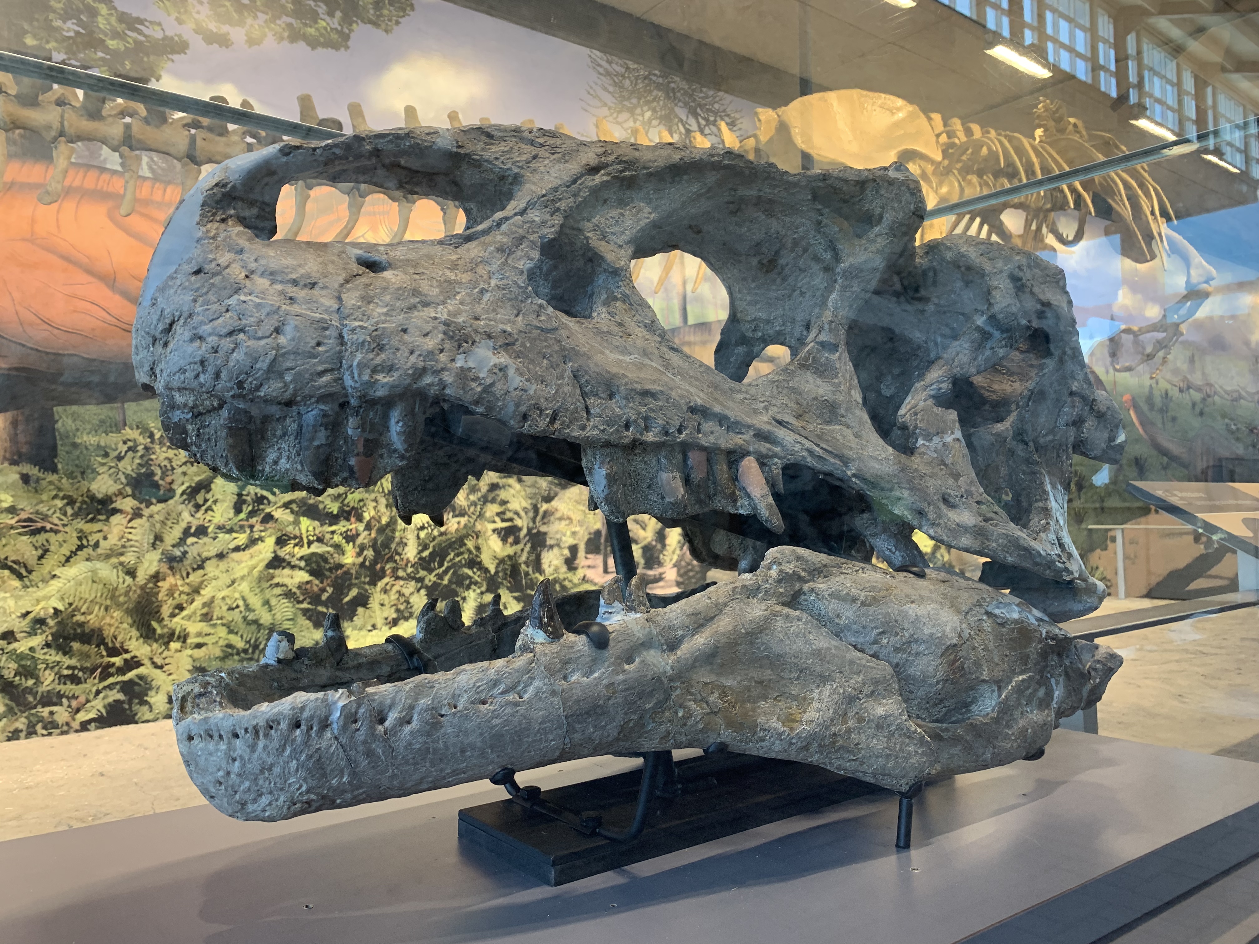
The Quarry Exhibit Hall, near Jensen Utah, has a crazy collection of large, late Jurassic dinosaur bones set in a two story high, very wide quarry wall, and you can touch them. It’s awesome. The Allosaurus skull above, a raptor talon-claw, Apatosaurus leg bones, and many Camarasaurus bones including a skull still set high in the quarry wall are all fascinating. This dinosaur exhibit is at the east end of the park after the Green River comes out of Split Mountain Canyon, and there’s a nice view, petroglyphs & pictograms.
Up the Green River is the extremely deep Canyon of Lodore, explored by John Wesley Powell, accessed from the north via permitted river trips or visible after a hike from the Gates of Lodore campground. There’s a conservation area north of the park in Utah named after Powell. Colorado’s Yampa River joins the Green from the east near Harper’s Corner, which has “the best view in the park” at the end of a hike and a 48 mile round trip drive. Unfortunately, I did not plan my charging to include either of those sections, so maybe next time.
There aren’t many good Tesla chargers around Dinosaur. Not sure why, but I noticed that some of the surrounding towns still support coal, have Halliburton operations, and have unfortunately unstable, irrational, fossil-fuel supporting representation in Congress. There’s a welcome center in Dinosaur Colorado with EV charging, but I don’t (yet) have the right kind of “combined charging system” CCS adapter. Since I’m in a hurry trying to visit high altitude parks during a short timeframe, I made due with a couple of 3rd party chargers I found using the PlugShare app, rather than stay in state park campgrounds. Especially when you get unexpected roadwork detours, being able to tap into other chargers is helpful.