Fort Matanzas National Monument

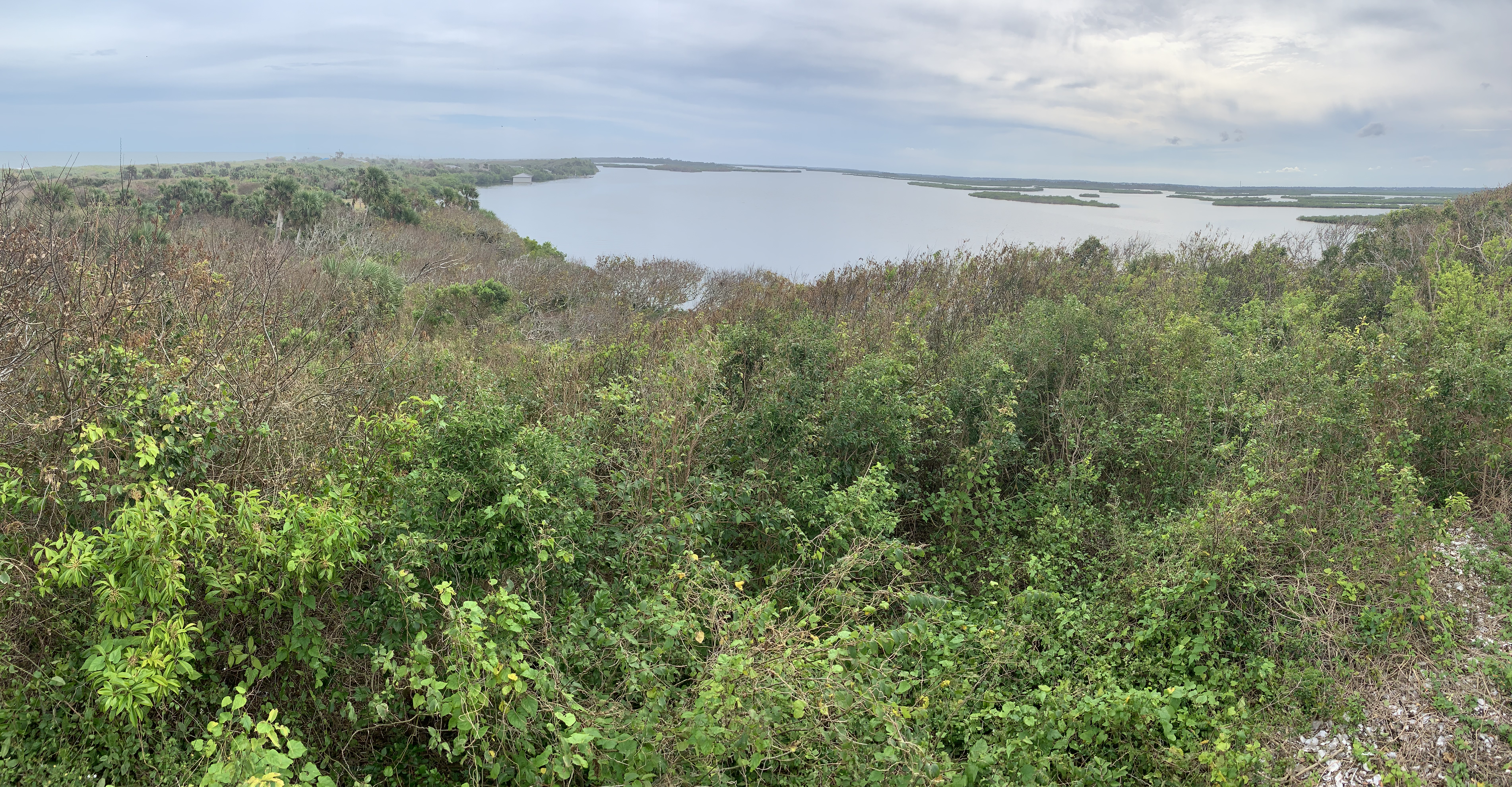
The shaded grove interests me, more so than the fort. In the southeastern US, a grove like this is called a hammock, a Native American word that entered European languages with two meanings shortly after Columbus visited around 1500. Hammocks, the sleeping nets hung between trees, date back to the Maya civilization in Central America, and the Taino in the Caribbean would have been the first to introduce those as ‘hammocks’ to Columbus. Perhaps the grove meaning stems from ‘net’ as a way to describe the interlaced canopy of branches. Or, perhaps an explorer pointed at a grove asking what it was, and a native answered “that’s my hammock”. The wonderful brief boardwalk hike covers a great variety of species. I saw a great horned owl, ghost crabs, eastern red cedar, sand live oak, holly & myrtle and the burrow of a gopher tortoise.

458 years ago and long before any fort, the inlet here—with its strategic opening to the Atlantic—was named Bahía de Matanzas, or ‘Slaughter Bay’. The French had settled on the Florida coast just before the Spanish, and in 1565 Fort Catherine sent 250 French soldiers down here to seize St Augustine, 15 miles up the inland waterway. But a storm intervened as their ships were crossing the bar, and they were shipwrecked. When they were discovered, the Spanish slaughtered them.

283 years ago, the British, under Governor Oglethorpe of Georgia, also tried to seize St Augustine, laying siege to to Castillo de San Marco for 39 days in 1740. The Spanish improved their defenses in 1742, including building Fort Matanzas to guard the southern approach. That same year, the British returned and the fort fulfilled its mission by firing warning shots across the inland waterway, helping prevent another sneak attack on St Augustine.

The fort itself is small and unremarkable, but it has a commanding view of the narrow channel. Unless you have your own kayak, you have to take a gasoline-powered ferry to get there (no ferry Monday or Tuesday). Of all the places to convert a boat to electric, this seems perfect. The ferry has a large flat roof that could charge up by solar and it only runs a short distance on a limited schedule. But for all the talk about “saving nature forever”, not enough practical steps are being taken to protect wonderful natural habitats like this from the climate crisis.

Castillo de San Marco National Monument

As you approach St Augustine, you may see the signs proclaiming it to be the nation’s oldest city. That’s not true, of course, there are several older, continuously occupied Native American settlements, including Acoma’s Sky City, Taos, Zuni and Oraibi. St Augustine is the oldest continuously occupied city in the US which was founded by Europeans. This euro-centric bias is even more inappropriate when you realize that the fort was used repeatedly by the US military to imprison many Seminole, 74 survivors of the Sand Creek Massacre, and many Apache.

This is my favorite fortress park. Still, too many Americans still haven’t heard of St Augustine, don’t know that the first thanksgiving mass with natives occurred here, that the fort was unsuccessfully besieged by the English (twice) and by the French, and didn’t know that the Spanish were here two hundred years before the US declared independence from England. So, a visit here is bound to be educational. The programs here sometimes include costumed re-enactors, gun firing demonstrations and tours of the various rooms, walkways and defensive lookouts, so it’s fun for kids of all ages. The fort’s strategic location means that it has a beautiful view of the boats traveling through, and years ago my kids enjoyed seeing a nearby museum with pirate treasure.

De Soto National Memorial

While the park unit is small, it is excellent, with knowledgeable rangers, many of these photographic outdoor displays, and an easy nature trail with beautiful birds along the Manatee River. There are frequent interactive events here, and the film in the visitor center is particularly well done, covering the important history of De Soto’s exploration and conflict with Native Americans.

The Spanish expedition from 1539 to 1543 was a brutal failure that cost De Soto his life and fortune, and it was his fault. After helping plunder the Incan Empire (Peru) in 1533, De Soto used his stolen gold to bring more Spanish soldiers to Florida to look for more gold. Some of the natives had recent run-ins with similar Spaniards, so they kept telling him, ‘sure, there’s more gold, but it’s a little further north’. Guides who failed to deliver the promised gold were killed. (Coronado was on a similar mission at the same time further west). De Soto took hundreds of natives captive as slaves, gave the women to his men, slaughtered thousands and told the natives that he was a deity, oh, and he brought a Catholic priest (see far right). For years, they marched through the southeast, killing, burning, pillaging, enslaving, raping and spreading disease. Many of the natives fought back, mimicking some of their brutal tactics, including the Chickasaw, who later owned slaves and fought for the Confederacy. After De Soto died of fever, his men gave up on his fruitless hunt for gold and maybe half made it back.

As horrific as that all was, several of the survivors wrote accounts of their first contact with the natives, and some of those accounts provide rare descriptions of the native cultures that existed (until the Spanish arrived). De Soto actually found an interpreter from Seville who had been adopted by a local tribe after his expedition starved to death, but he later died on this new expedition. One survivor’s record clearly states that a nearby shell mound was the foundation for the local chief’s dwelling, proving that the mounds in Florida were not simply middens but were built intentionally as elevated platforms for important people and functions, contradicting the park film at Canaveral. A large mound on this site was removed for building roads, before the park service began protecting them. After all the death and destruction inflicted on the natives, it feels especially cruel to erase the last remaining remnants of their culture without acknowledgement.

Canaveral National Seashore

Florida is famously flat, but above there’s an impressive view of the beach, lagoon and islands from the top of Turtle Mound near the Apollo Beach visitor center. There’s a kayak trail through the lagoon with campsites, and further south, there’s a scenic drive and nature hike in the neighboring Merritt Island National Wildlife Refuge. The Timucuan people who built the mound disappeared under Spanish rule—from 40,000 to “a handful” in the 18th century—, so they can’t tell us why they built these mounds. Talking with the ranger and watching the park film, I was told that the shell mound was simply a midden, or dump, from the large feasts that the Native Americans enjoyed here: “only trash”.

I said, “really” and asked why anyone would pile their empty shells 40 feet high when they could just toss them in the water? These mounds survived centuries of hurricanes, before most were excavated to build roads. The Spanish used the shells to build strong “tabby” forts. So isn’t it likely that this sturdy, flat-topped platform next to a trade route with views for miles was built for some structural purpose? I was told “no evidence for that”.

Clearly the park film and the ranger underestimate the Timucuan. It takes no great leap of imagination to realize that Native Americans shared common cultural customs and built large mounds for ceremonial, funereal, calendar and other purposes. See Poverty Point, Ocmulgee, Cahokia, Hopewell and Effigy. Ignoring the pattern takes willful blindness and shows a lack of respect for Native American culture by the people who now live here.

Anyways, I had to be out of the park before the night launch of Artemis I from the Kennedy Space Center next door. NASA preserved this largest undeveloped Atlantic coast, and the seashore, lagoons and waterways host critical ecosystems for fish, birds and more. The endangered Right Whale winters off the coast, and the vulnerable West Indian Manatee breeds, raises young and migrates seasonally. In the warmer months, manatees can be seen at the Haulover Canal or from Turtle Mound. Some manatees winter in the discharge of a nearby natural gas electric plant, but most winter in natural hot springs like Blue Spring State Park, where I hiked their cypress swamp boardwalk to the deep blue hole and found a couple early ones. The manatee’s natural territory is much larger than the park boundaries. Some boaters disregard Slow signs, support removing all safety zones from rivers and even advocate legalizing lethal manatee strikes, just so they can bomb around in their noisy carbon polluting toys. We need to learn how to coexist with nature, not kill it.

Congaree National Park

Congaree is one of my favorite parks, so I saved it for my last entry of the year. Once, every river in the southeast was filled with hardwood forests like this, supporting many species of birds, fish and wildlife, and keeping our air and water clean. Now, this may be the last great one left. Around late May, the fireflies blink in synch, so you’ll need to plan months ahead if you want a campsite then. The 2.5 mile boardwalk hike from the main Harry Hampton visitors center takes you past a few of the tall trees that fill the swamp: beech, bald cypress, water tupelos and loblolly pines. The latter are the largest, most massive pines in the eastern half of the US. Congaree may have been saved much more recently than some of the more famous parks in the west, but for biodiversity, it is exceptional.

Of course, being basically a swamp or flood plain forest in the middle of a giant watershed stretching from the Blue Ridge Mountains to the Atlantic, the best way to see the park is by paddling. I dragged out my trusty OruKayak and spent several glorious hours exploring Cedar Creek by myself. There were folks on tour at the boat launch, but once on the water, I didn’t see anyone. Longer trips can be arranged on the Congaree River. Several people asked about my kayak, including a couple that happened to be from my old hometown, and I explained that it is lightweight, a bit tippy, and fits easily in the trunk of my Tesla Model 3. (I know everyone is hating on Elon right now, but he made a good car, as long as you don’t use the autopilot).

Apologies for botching another photo, but I should point out that the knobby things sticking up from the bank on the left are the knees of the bald cypress. They say it’s a mystery why the tree has knees, but obviously, the knees help dry out the roots, preventing rot. Above them, you can see some dwarf palmetto illuminated by the sun, and further upstream, the creek was blocked by falling trees, which are becoming more frequent with climate-crisis fueled storms. I also heard a variety of birds, although most of them flew away as I approached. Definitely worth bringing a map & GPS, since there are many side routes and obstacles that may require changing plans on the water. Beautiful.

Chattahoochee River National Recreation Area

The park runs along the riverside in 16 different mostly contiguous sections, just north of metro Atlanta. The view above is from an overlook in the East Palisades section, specifically between EP 10 and EP 14 near the Indian Trail entrance. The treacherous whitewater mild shoals in the river above are known as the Devil’s Race Course, not for downstream paddling difficulty, but because it used to be “a devil” to move cargo up the river here.

Parks near urban areas means more people enjoying nature, and even on a chilly autumn day there were plenty of folks out jogging, hiking, biking and dog walking. One young lady appeared to be in deep meditation at the river’s edge, while her dog intently watched some geese on a sand bar in mid stream. It would have been fun to kayak through the park, but I couldn’t figure out a good way to get all my gear back to my car. With limited time to visit other sections, I spent my time on a beautiful long hike along the river and up in the wooded hills.

Crunching through the leaves reminds me of running cross country as a boy during the fall in New England and leaves time to reflect on loss and letting things go. Life is not perpetual youthful summers, and the decay that comes with the passage of time prepares the ground for new life and the next generation. The bittersweet changes of seasons and life should be learned from, embraced and cherished, not denied nor medicated away.

“Good night, good night! Parting is such sweet sorrow,
That I shall say good night till it be morrow.” 

— Juliet

Potomac Heritage National Scenic Trail

[When planning my trips for next year, I realized I skipped my September visit here. Sorry it’s out of order.] The kayakers have the best views of Great Falls, and they helpfully show the scale. The falls themselves are rated V+, meaning lethal, but there are less dangerous sections of the Potomac nearby. From the C&O NHP right across the river, it’s a 30 minute drive to get over here to the Virginia side of the falls. There are miles of beautiful hiking trails along the river with many deer that are used to people.

The PHT proper is on the Virginia side from above Great Falls down to Prince William Forest with the Mt Vernon Trail in the middle. But the broader PHT also includes the Potomac River itself, the C&O, Laurel Highlands (between Johnstown & Fort Necessity), the Great Allegheny Passage, the Civil War Defenses Trail in DC, the Mt Vernon Trail and the Southern Maryland & Northern Neck PHT Bicycling Trails on both sides of the Potomac. While I plan to visit more of those next year, it occurred to me that I may have already seen the most scenic section above. So, in case I don’t have enough time for a longer paddling & bicycling trip between Pennsylvania and the Chesapeake Bay, consider this my official park visit.

Little River Canyon National Preserve

One popular question is itinerary planning, which is essential, although my plans never survive contact with the road. The same trails must be picked up again in different seasons, and inevitably, they retrace the steps of early Americans. The old hunting grounds, early trade routes, forts and battlegrounds often overlap in places like this, and, especially when they’re preserved in a more natural state, it’s easier to imagine those who came this way before us.

After their long history of interacting with the Spanish, French and British in the southeast, five tribes had become accustomed to European ways enough to be called “civilized”: the Choctaw, Chickasaw, Creek, Seminole and Cherokee. But the US government forcibly removed them to Oklahoma anyway. Most crossed the Mississippi near Memphis, as I did. The Cherokee were split into three groups: the old settlers who moved west before the removal, those forced to walk the Trail of Tears, and those who escaped removal and still live east of Great Smoky. Here, at a natural crossing point through the canyon palisades, the couple in the photo above walk on the Trail of Tears, near where Cherokee families were rounded up into a wooden palisade known as Fort Payne.

The park helps preserve that history, although the primary mission is to protect the many species that live in this important nature sanctuary. The canyon is known among rock climbers for the challenging cliffs, and if you hike downstream there’s a swimming hole near Martha’s Falls. The river isn’t runnable by amateurs, so stick to the scenic drive along the rim, admire the views from a half dozen overlooks and try not to miss the peak foliage like I did. The road isn’t wide enough for both bikes and cars, and, as usual, the former lose out. There’s a park film at the friendly visitor center and an Ol’ Tymer’s BBQ nearby.

Time for me to get back on the road. I passed through Muscle Shoals on my way here, but now I have Georgia on my mind. Places like this are bittersweet, when you reflect on the past or consider the future, but that’s what enriches travel. And our choices make a difference too. Supporting Native American businesses, for example, seems the least we should do to recognize past wrongs. And unless we stop our carbon pollution, these small sanctuaries will prove insufficient to preserve diverse species for any who may follow us.

Chickasaw National Recreation Area

While the Lake of the Arbuckles is popular for wasting gas zooming in circles on the water, I think the hiking is the best form of recreation here. The smaller Veterans Lake is reserved for paddling, but since you can see everything from the boat ramp, there’s no point. I hiked for a couple miles near the Travertine Nature Center through the ecotone that ranges from Redbud to Cactus, along the CCC developed creeks and mineral spring pools, admiring the foliage, the tall Sycamores and various Oaks, and I watched an armadillo digging around in the brush. There are half a dozen simple campgrounds, and when the water is flowing there are many small waterfalls and an old pavilion where they used to bathe in mineral waters. Once tourists observed bison wallowing in the muddy pools, but now the area suffers in man-made drought.

To prevent over-development, the Chickasaw and Choctaw nations sold the springs and surrounding forest to the Interior Department, hence the name. I very much recommend visiting the neighboring Chickasaw Cultural Center, which connects to the park by the pedestrian Inkana Bridge. There I observed a pair of Great Blue Herons, admired the pollinator gardens, toured the replica village, watched a stomp dance, and learned about the tribe in their beautiful museum. The history of the Chickasaw is tragic, fascinating and inspiring, including conflicts with the Spanish, French, British and the US. My trip to the southeast goes in the direction their ancestors traveled many centuries before the tribe was removed to Oklahoma.

Lake Mead National Recreation Area

Apologies for the twisted Pano, but I’m still getting the hang of my new kayak. This is Black Canyon, and the hand-pulled cable car was built so the guy in charge of gauging the river could get from his house to the gauge station via the catwalk on the cliff to the left. I paddled up part of the Black Canyon National Water Trail a couple miles from Willow Beach to get a decent photo of Emerald Cave, which also failed (I blame the low water level and too many people). But in the sunlight, the shallows along this stretch of the river do turn a beautiful green, and seeing the fish and ducks helps emphasize the importance of the Colorado River to life in the desert.

There are many different ways to recreate in the area, but this self-guided kayak tour appealed to me. I think I’ll keep my OruKayak in my trunk for trips just like this. There are longer paddling tours from Hoover Dam, a paddle wheeler, boating on Lake Mead, backcountry horseback riding, hiking, biking, scuba diving (historic plane wreck) and many more. I took the kids to tour Hoover dam years ago, and it’s fascinating. This trip I stayed just outside the park downstream below Davis Dam (which forms Lake Mojave) at the Pioneer in Laughlin, which was cheap and had free overnight EV charging (ClipperCreek). All the Colorado River lakes are in trouble now, due to the climate crisis and misuse of water, so I wanted to visit before things get worse.

100 years ago yesterday, the Colorado River Compact was signed. Ecology, Native Americans and Mexico had no input. Today, more water exists on paper than in the river. The states say they are unwilling to renegotiate, but every year the cities get bigger and the water levels drop. Like other human activities, our use of the river is unsustainable. As thankful as I am that this area is preserved for recreation, unless we do something, it won’t be for long.