This sleepy foal was waiting by the roadside while his Mom grazed. The wild horses on the Maryland shore have adapted since escaping Spanish shipwrecks maybe 400 years ago. Their fur is thicker, legs short & stocky, and they have large bellies to help process the extra water needed to eliminate all the salt on their fodder. Colonists also kept horses on the island to evade livestock taxes, so the gene pool is healthy. The park service has an innovative birth control program to limit the mares to one foal, which involves firing (and retrieving) darts, and that keeps the population under control. While they’re not a native species, the environment would likely have had some ungulates (hooved animals), so the park service supports this popular wild population that run free on the entire island.
The park is in the Delmarva area—meaning Delaware, Maryland and Virginia all share the peninsula—, and the island runs around 40 miles along Maryland’s Atlantic coast. The Chincoteague Bay side is more scenic with more birds, but the beach side gets more visitors. There are a couple easy boardwalk hikes at the north end, along with a state beach section and access to the long roadless midsection. The Marsh Nature Trail was the prettiest when I visited, but check conditions at the visitor center before crossing the bridge to the island. The Virginia end of the island supports a different, less wild herd which is managed by ‘saltwater cowboys’, mostly firefighters, who sell the excess foals.
The park is in Virginia and connects to Great Smoky via the Blue Ridge Parkway: hundreds of miles of winding wild beauty. The skyline drive is wondrous and many of the outlooks are magnificent, but you really should stop and go for a hike. The ultimate hike would be the Appalachian Trail, but there are many shorter ones of varying difficulty. I saw folks biking, but most looked unhappy. The park ranges from 1400’ to over 4000’ with lots of ups and downs for over 100 miles in between.
Many folks stop in the middle at Big Meadows (milepost 50) which has a Visitor Center, big campground and lodge with restaurant and taproom. I was less interested in the meadow than the forest, so I stopped at Skyland (milepost 40 from the north). They don’t have a visitor center or campground, but they have a lodge, similar dining, horseback riding and free EV charging (J1772 & Tesla Destination).
From there I hiked west past the old Massanutten Lodge and out to Miller’s Head, where a family told me about the Whiteoak Canyon trail on the east side. So I added another 5 round trip miles to get to the waterfall above, where another nice family helpfully provide scale by standing near the top. It’s easy to spot a dozen types of wildflowers, birds, and larger wildlife. About a dozen deer crossed the road ahead of me, so drive carefully!
Everyone may already know this, but neither the Shenandoah River, Valley nor Mountains are within the park. Those are all to the west, and the best place to see the river is from the Shenandoah Valley Overlook near the north entrance.
In July of 1929 the police raided the Blue Blazes Stills here and a deputy was killed. The original operation was destroyed, but bootleggers produced thousands of gallons of ‘whiskey’ in 18 huge vats. When FDR was elected to deal with the Great Depression, he decided to clean up the eastern end of the Blue Ridge Mountains in northern Maryland, regrow the forest and employ people to create campgrounds, trails, rustic lodges and the bootleg still exhibit above. Camp David is in the immediate vicinity, and since I wasn’t invited there, I stayed here in one of the historic lodges at Camp Misty Mountain in my sleeping bag, a short walk to parking and restrooms, for $50. The sites are open from May to October, tent sites cost $30, larger facilities are available for groups, and there’s even an accessible pool, which FDR would appreciate.
These are the Quantico Falls, within this massive 16,000 acre Virginia park with CCC campgrounds. There are remnants of natives, freed slaves and farmers ‘displaced’—evicted by the government—during the Depression. In WWII Wild Bill Donovan took over the park to train his OSS spies in the forest. You’ve probably heard of the nearby Marine & FBI bases. Now, the park is popular for camping, hiking, biking and orienteering.
Honestly, the show was disappointing, but not every show is going to be like the Doobie Brothers’ Live At Wolf Trap. If you go, be sure to book your tickets months in advance to get seats to the most popular shows. Lots of folks arrived early to sit on the lawn in ‘general admission’ up above the seats, watching on big screens. I’d prefer just to hike the 2.5 mile trail through the Virginia woods, but I braved the crowds for the experience. And it was fun, so I shouldn’t complain that the artists were a bit out of tune and didn’t have much of importance to say. At least the expensive beer and crab cake sandwich tasted pretty good, so, except for my hearing loss, it was a good night.
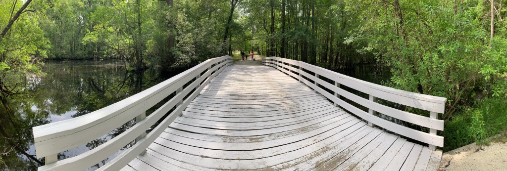
To say the gap is in the Poconos is redundant, because ‘pocono’ means water gap in the Lenape language. The whole area was supposed to be inundated by a flood control project, but that was deemed too expensive. Which is great, because the park service preserves big, beautiful, wooded, hilly land on both the New Jersey and Pennsylvania sides. There are at least seven named waterfalls with trails—above is one of two easily seen on Dingmans Creek Trail—, more hikes including a section of the Appalachian Trail, an exceptional bike trail, many campgrounds, some historic buildings and more. A brown bear crossed the road in front of me, so there’s definitely wildlife here too.
Technically, the 35 of 40 miles of river itself is a separate park, and the gap is the land plus 5 miles of recreational river. If it were up to me, I would combine this with the Upper, Middle and Lower Delaware River parks, and make all four into one National Park. That’s been proposed, but some residents oppose it. Traffic or something. I found it easy to drive around, but crossing the river gets you a toll. If we want to preserve species, we need to start being much more aggressive about preserving our rivers and forests.
Inside the Zane Grey museum in Lackawaxen PA, there are a couple of photos Grey took that make me extremely envious. One is him in 1920 sitting under Rainbow Bridge—which is a park site that I honestly can’t figure out how to visit—, and another is of his three masted schooner Fisherman in 1932, on one of his many adventures at sea. Grey introduced the world to the great American West, writing dozens of novels selling millions of copies in several languages along with movie and TV adaptations. I consider myself a bit of a traveler now, but many times I’ve reached a remote place, only to find that Grey beat me there by 100 years, on horseback or by boat. My grandfather and uncle inspired me with their travel stories, and I now have their journals of their trips out west with me to compare notes (thanks Nim!). I also have a decent collection of Zane Grey ebooks, although I read them mostly for the journey descriptions. Zane and his wife loved this place on the Delaware River, and I’m sure he’d have loved to see so many people taking their families out on small boats right off his front porch.
This is the middle of the river, in the middle of the park, in between the upper and lower sections of river, between Pennsylvania and New Jersey. Fortunately, it was calm enough that I got a mostly undistorted panorama, but there are a few fun class I rapids on the 10 mile section I paddled from Bushkill Access to Springfield Beach ($10 parking). The river is gorgeous, and I saw at least a half dozen bald eagles. It was surprisingly easy to catch the free hourly summer weekend ‘river runner’ shuttle to bring my kayak upstream. The driver let me bring mine inside folded, but other paddlers I saw put their boats on the canoe/kayak trailer.
The bus is also called the ‘Pocono Pony’, and it’s a lot of fun to chat with other riders. I was bragging about how many parks I had visited, when the guy next to me said he had been to all of them. He’s a riot, and he was on TV for #413. We chatted on the bus & river and compared notes. Well, mostly he chatted. In his old job, I think the conversations were mostly one-sided, since he’s a dentist. I enjoy meeting interesting folks, especially when they’ve got a great sense of humor and can teach me more about our parks.
Read the chronology of the Revolutionary War below, and click on the links to read my visits to each battlefield park by Electric Vehicle. Our country’s independence was the result of many hard fought battles, bravery, determination, moments of military genius, critical help from our allies and luck. Visiting the sites helps bring to life the story we should all know.
On the 19th of April 1775 at the Old North Bridge in Concord, Massachusetts, the embattled farmers resisted British efforts to take their stockpile of weapons and fired ‘the shot heard round the world’ against the world’s dominant military power.
After the British retreated from Concord to Boston, the rebellious colonists tried to trap the British in Boston. The monument on Bunker Hill commemorates the siege in June 1775, but the Americans were unable to defeat the British that year.
The first significant Patriot victory happened in Moores Creek North Carolina in February 1776 at a bridge much like Concord’s, where Scottish Highlanders charged with broadswords and were cut down by muskets behind low earthworks.
That same winter, Henry Knox brought captured cannon from Fort Ticonderoga in New York on sleds to Boston, surrounding the British. They withdrew to Canada in March 1776, but that summer the British took New York City. Washington crossed the Lower Delaware River in December 1776, defeating the British at Trenton and Princeton, but he was unable to dislodge the British fleet or army from New York.
In 1777, the British tried to join their Quebec & New York forces and to take the de facto capital of the colonies, Philadelphia. At Forts Stanwix and Saratoga (see photo) in New York the Patriots defeated the British in August and September 1777, convincing the French to help us. But the British landed troops in Maryland and took Philadelphia from the south.
Washington trained and wintered with his army in Valley Forge in 1778 and 1779 and in Morristown 1779 and 1780. The most notable victory in that time was when George Rogers Clark took Fort Sackville Indiana in February 1779, winning control of the lands bordering the Great Lakes. In Georgia around the same time, the Patriots also briefly took Savannah and won at Kettle Creek.
But in 1780 in South Carolina, the British took Charleston and set up HQ in Camden brutally trying to retain their control of the southern colonies. In October, reinforced via the Overmountain Victory Trail, the Patriots won at Kings Mountain South Carolina. In January 1781, the Patriots executed a rare maneuver to win at Cowpens South Carolina, but Cornwallis eked out a costly victory at Guilford Courthouse North Carolina in March. Then in June the Patriots failed to take the British fort at Ninety-Six South Carolina. But at places like Eutaw Springs, the Patriots continued pressing the British into retreat back to Charleston. Read more about my visits to southern campaign sites.
The war may have continued for a couple more years, but our French allies helped us win the critical victory that fall. Washington and Rochambeau secretly marched their combined armies down the coast to Yorktown Virginia, while the French fleet blocked the entire entrance to the Chesapeake Bay. Cornwallis surrendered on the 19th of October 1781.
Christmas night 1776 was a bad one. The Revolution was going poorly for the Americans. The British Navy had taken New York City and controlled the whole area. Some American militiamen were heading home, and the British had reason to believe they would win the war soon. Their regular army left Hessian mercenaries in charge of camps along the Delaware, but as the river was filled with dangerous ice flows, patrols were limited. Not that the German soldiers were drunk, mind you. They were professionals, and they were keeping careful watch, despite the storm.
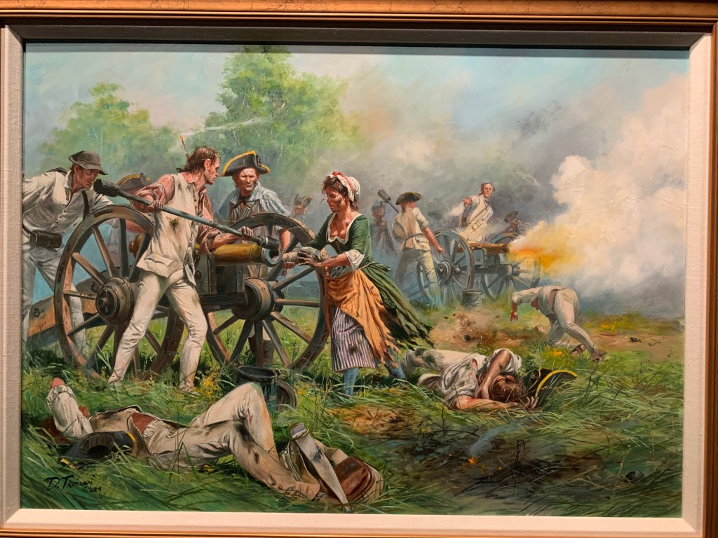
George Washington wasn’t going to let the weather or river stop him. He wrote ‘Victory or Death’, and loaded his 2,400 troops and 18 cannon into sturdy river cargo boats which made repeated trips across the Delaware River (see photo) from Pennsylvania on the right to New Jersey on the left. Two other crossings had been aborted, and the storm was getting worse. It took longer than expected, but by around 4 am, his troops (and horses) climbed the hill and began marching south towards Trenton. The Hessians fought back, and the British reinforced. But Washington won three battles, two in Trenton and one in Princeton, before making camp in the mountains. The war would not be over as soon as everyone thought.
The New Jersey side of the crossing has a large wooded park on a hill, with trails and a small museum with some interesting artifacts. The Pennsylvania side has a museum, replica boats and some historic buildings along the river. I took the photo above from the narrow bridge as I walked between them. The lower section of the Delaware is either a full park unit or an affiliated multi-partner site, depending on who you ask or which website you check. There are roads and a fair amount of development on both sides, so it’s not particularly wild or even scenic in stretches. The designation seems aspirational to me. But our rivers do need more protection, and there are many interesting historic places on both sides of the river. Congress did authorize parts of the lower Delaware as ‘wild & scenic’ in 2000, but if you paddled it, you’d go in and out of those every few miles. There are no federal facilities, so although the park website calls it a ‘unit’, I don’t think it counts towards 424. Still, just in case I’m wrong, and out of respect for our first Commander in Chief, I humbly post.