There are three main outer banks—‘OBX’—islands in the park: Bodie, Hatteras and Ocracoke, from north to south. Each has a lighthouse: Bodie is currently open for climbing, Hatteras is tallest and Ocracoke is oldest. I brought my kayak and stayed at Oregon Inlet campground across from the Bodie harbor which has a kayak launch, but there was some construction, commercial traffic, and strong, cold winds in May. Also, since the islands are so long and thin, it’s easiest to see the main sights by driving the 70 miles, including the free vehicle ferry to Ocracoke.
Hatteras island is the biggest, with several year round towns and thousands of residents outside summer, when hundreds of thousands visit the OBX. The road gets damaged in storms, and wind often blows huge drifts of sand onto the road. Many of the residents have anti-Biden signs, which is counter intuitive, since he is trying to defend them from the Climate Crisis, which will steal their land, take over their businesses and even invade their homes. But they ignore the science, the melting glaciers and ice caps, the strengthening storms, the sea level rise and the increasing erosion. The lighthouse has already been moved many times. The OBX is one of the fastest growing real estate markets on the NC coast, worth tens of billions of dollars, even as homes are falling into the sea. Money appears inversely related to intelligence.
The delightful nature walk above is Springer’s Point Trail at the southern tip of Ocracoke nearer Cape Lookout, the northern tip of which can be visited by passenger ferry leaving from Ocracoke’s picturesque Silver Lake Harbor. There are some ‘banker’ (OBX) horses on Ocracoke, but they’re penned, not really wild.
I recently completed visits to all national park units in the Mid-Atlantic region by electric vehicle, including First State in Delaware, 4 in New Jersey, 5 in West Virginia, 13 in Maryland, 16 in Pennsylvania and 17 in Virginia. I have also completed all the NPS affiliate sites, national heritage areas and NPS run trails in the region. Parks that stretch across multiple states count in whichever state I focus more of my visit, and I pick a few favorites at the end.
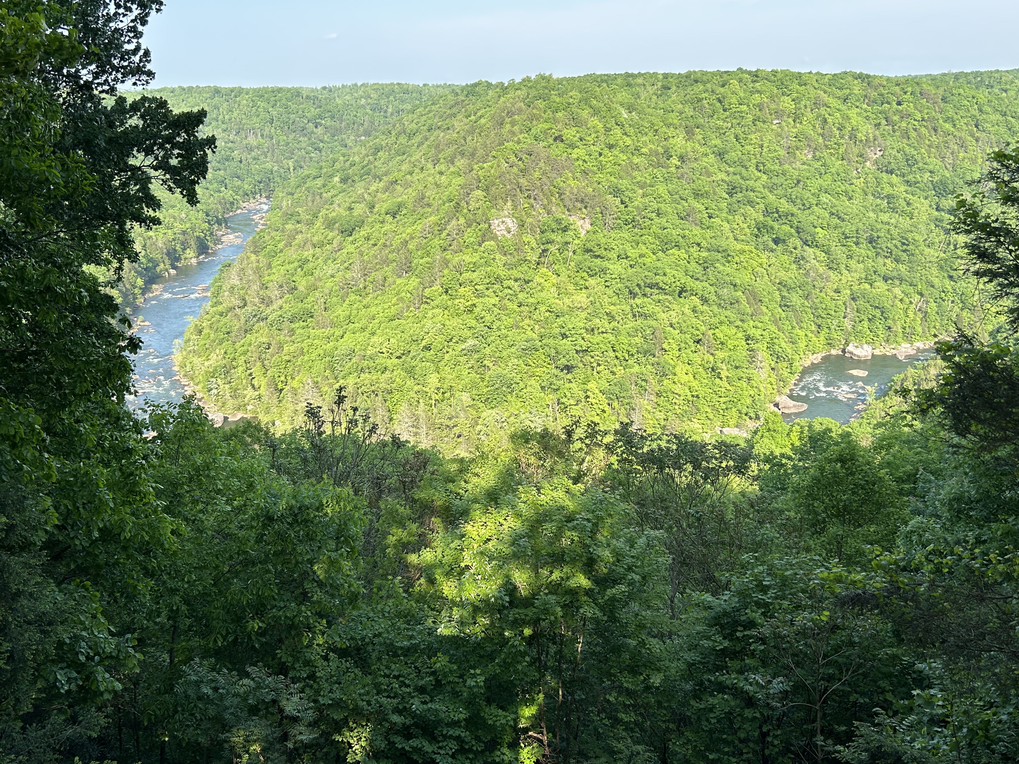
West Virginia is almost heaven. Harpers Ferry is one of my favorite parks and it hosts the Appalachian Trail HQ. The three river parks, Bluestone, Gauley and New—a National Park—, contrast the dangerous and polluting history of coal mining with the beauty of nature when given our protection.
The bridge over the gorge is huge; it’s one of the highest in the world and the largest single arch bridge in the western hemisphere. I took some nice pictures of it, when I drove the old Fayetteville Station Road and crossed on the old one lane bridge. Some of the commercial raft trips end there, and it’s fun to watch them take their last rapid. The most crowded part of the park is the Canyon Rim Visitor Center near the bridge, where many folks stop to have ice cream or picnic.
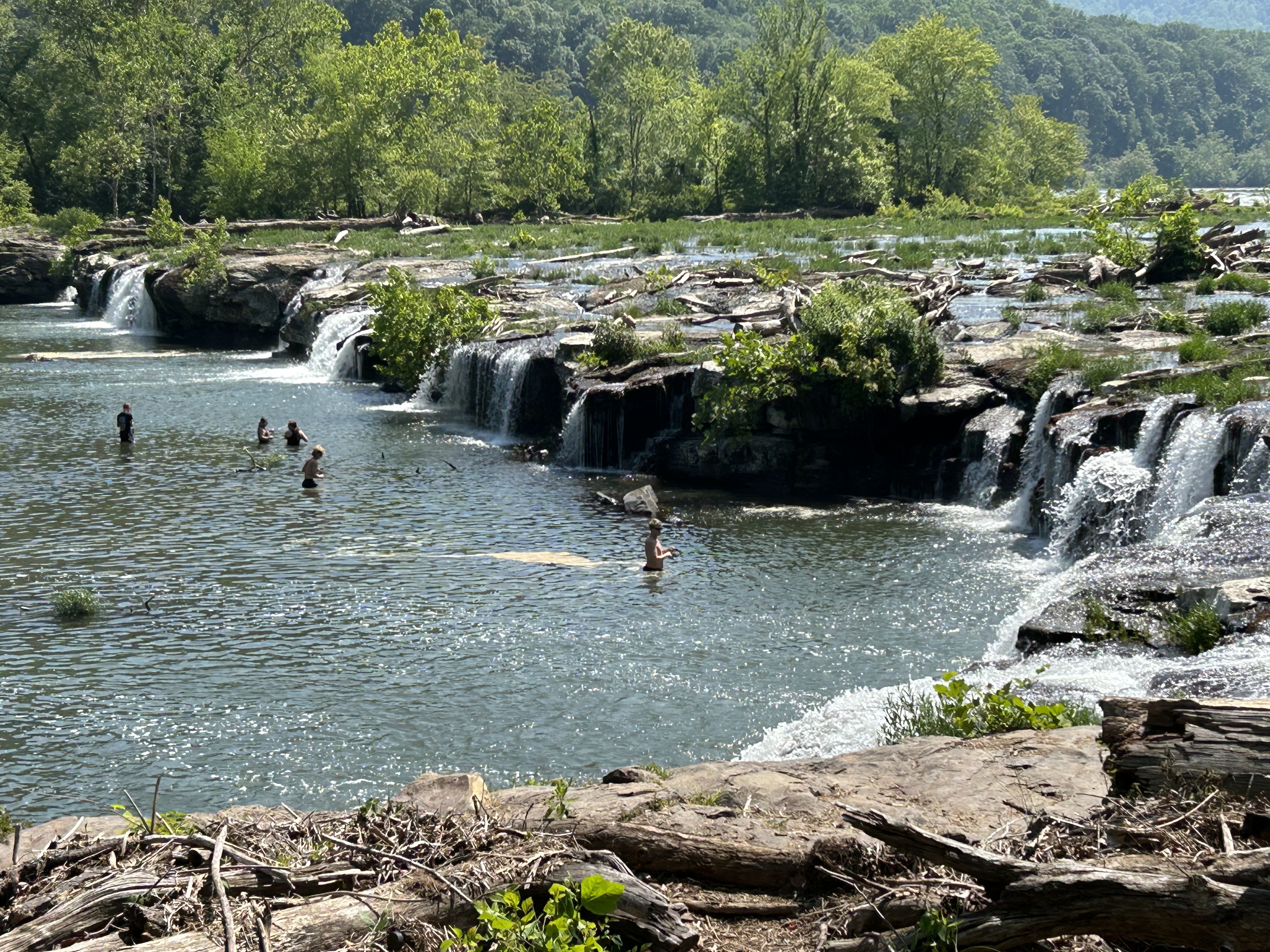
But the bridge is not the point of the park. The New River watershed is huge and very old. It starts in North Carolina near the Blue Ridge Parkway, includes the Bluestone and Gauley scenic rivers, and flows up to the Kanawha which is a major tributary into the Ohio River. The photo above shows folks fishing at Sandstone Falls, far upstream of the famous bridge. It’s a lovely spot with plenty of birds, an easy hike and a boardwalk.
The point is that the whole area was ruined by coal mining. This was the land of John Henry, if you know the old song about a railroad tunnel dug here. Now coal is more expensive than renewable energy, and many of the mines here have closed, becoming ‘exhibition mines’—fascinating tour in Beckley—, historic sites or slowly forgotten. A few coal trains still run through the gorge, but the park is now protected and recovering. Tourism generates more income and jobs now, and West Virginia is one of the most beautiful states in the US. The park is proof that we can change and improve. The point is that we can choose to save nature, instead of destroying it, and that it’s never too late to start trying.
Well every Monday morning When the bluebirds begin to sing You can hear John Henry a mile or more You can hear John Henry’s hammer ring, Lord, Lord You can hear John Henry’s hammer ring
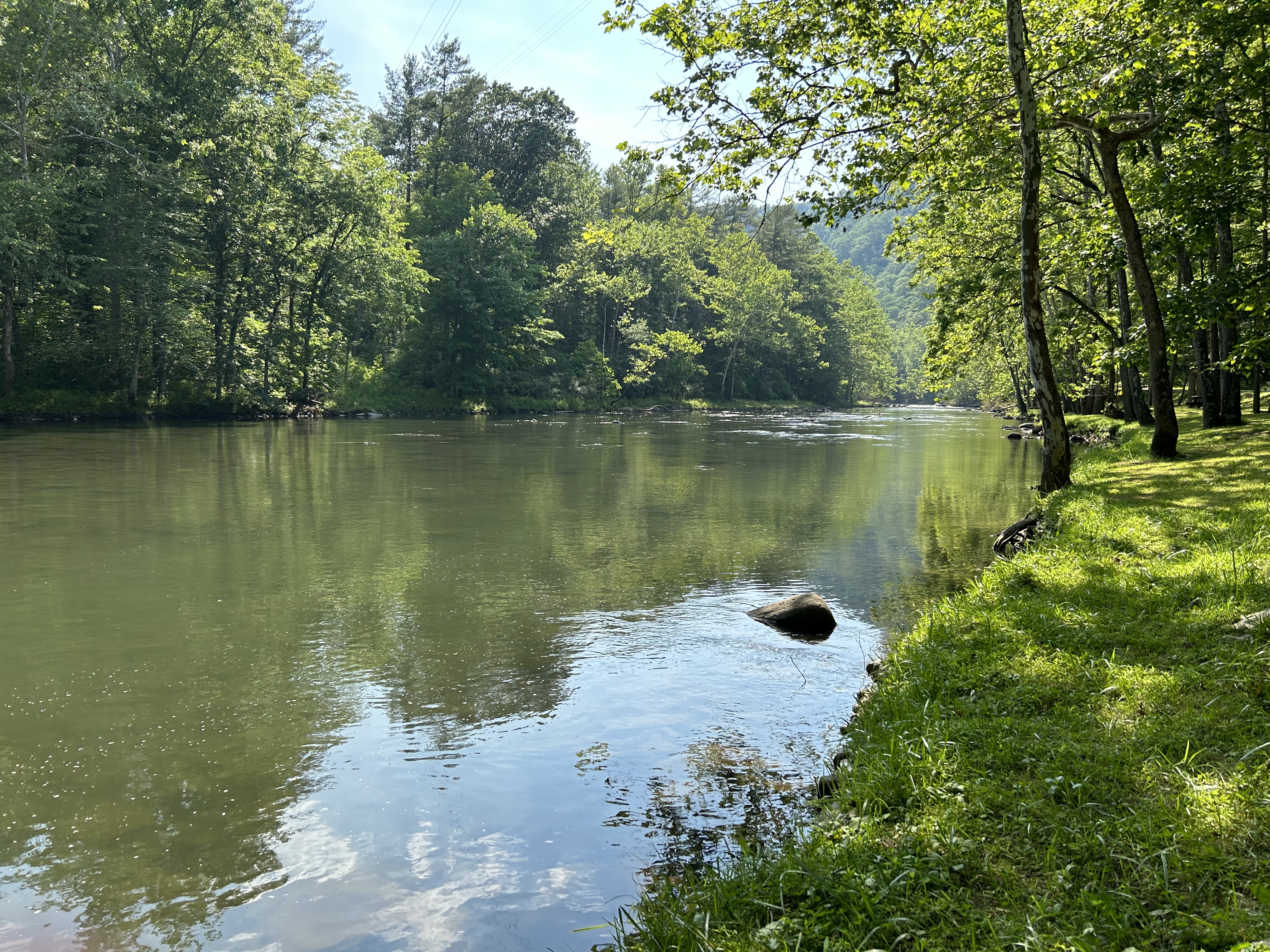
Like Gauley, this park is managed by New River Gorge and is best visited by going through a state park. Pipestem Resort State Park has a aerial tram which runs on weekends and more often in summer, and—even though it runs on gas—I recommend it as the best way to get down to the river 3,600’ below. (Look for the old moonshine cave on the way back up). Then you can hike along the beautiful river trail (see above) for as long as you like. West Virginia is wild and wonderful, and this particular river is simply stunning.
Upstream is the large Summersville Lake, which is drained each fall, creating a spectacular world class 25 mile whitewater kayak run for a few weekends through these woods and around the Pillow Rock Rapids bend above. The rest of the year, the West Virginia park belongs to the wildlife, without any significant visitor facilities and few easy access points. Information on hiking trails is available at New River Gorge nearby.
Obviously the whitewater is above my skills even if I waited until September, so I just decided to admire the views and hike in the beautiful woods. The best place for that is not the park campground—which is just a parking lot and kayak launch at the base of the Summersville Dam.
The place to go is the Carnifex Ferry Battlefield State Park—which commemorates the Civil War Union victory that helped drive the Confederacy out of western Virginia eventually leading to the creation of West Virginia. This is where I took the photo above, and where I walked into the park on the old ferry ‘road’ or trail. The state park is day use only, but it has nice facilities, beautiful lawns and a monument.
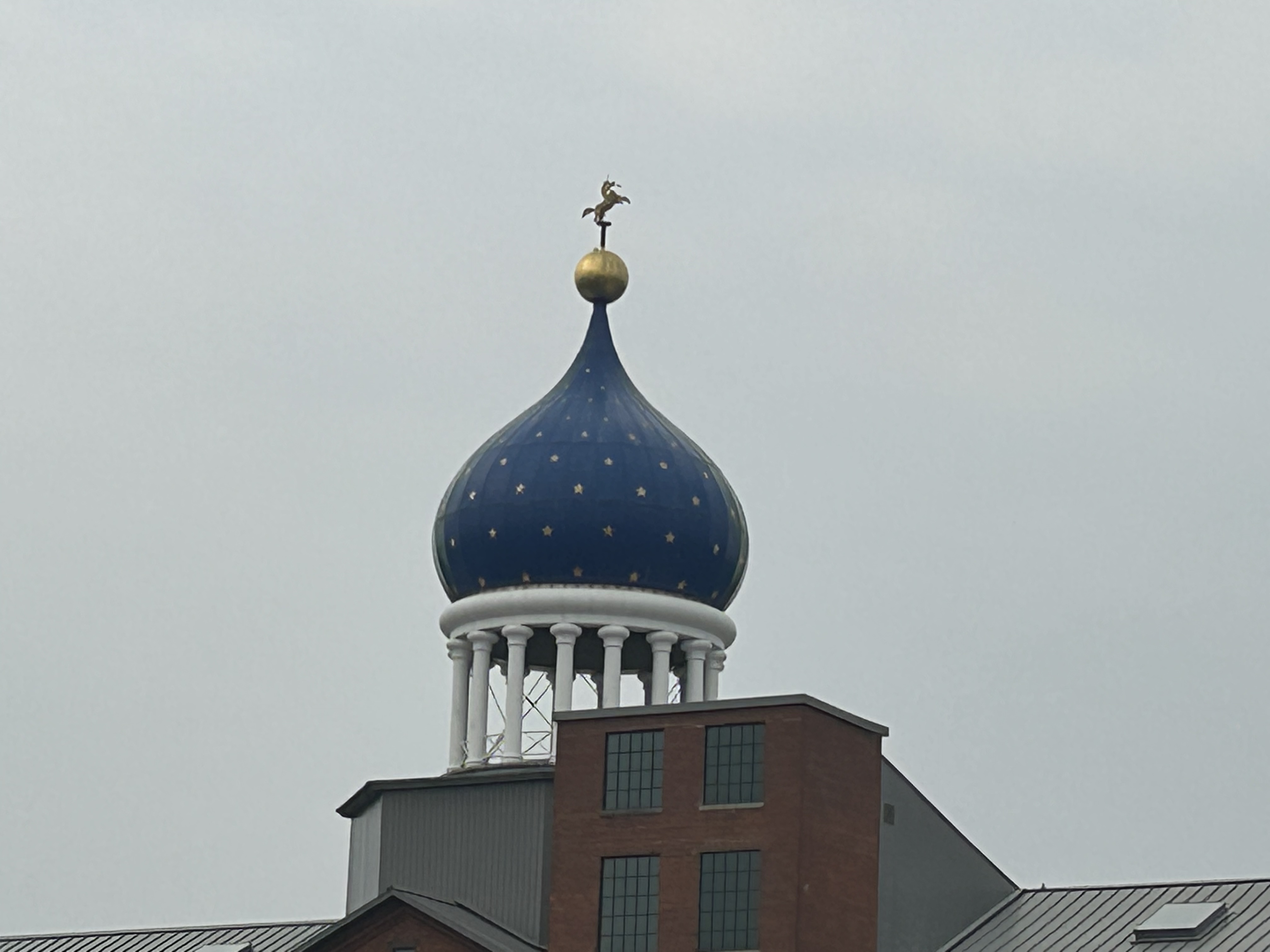
Samuel Colt sold a lot of guns to Russia, one of their first major clients, so he built the original iconic onion dome that defines the Hartford CT skyline (the one above is a replacement after a fire). You may notice the “rampant colt” on the top, which symbolizes loyalty, as the animal is breaking a lance to defend its fallen knight. The dome is actually one reason for the delay in converting the park to full status, as leaseholders control access to the dome which the park service needs. The two original brick buildings that the park service owns are in dire need of restoration too. There’s a nice walk through the large recreational Colt park to find his estranged brother’s house and through the company town to a church commissioned by the widow Elizabeth Colt, who ran the company for decades. Until this park opens officially, you may want to visit the Springfield Armory to learn more about the development of guns in the Connecticut River Valley.
My remaining parks are fewer and far between, so starting today I’m posting every other day.
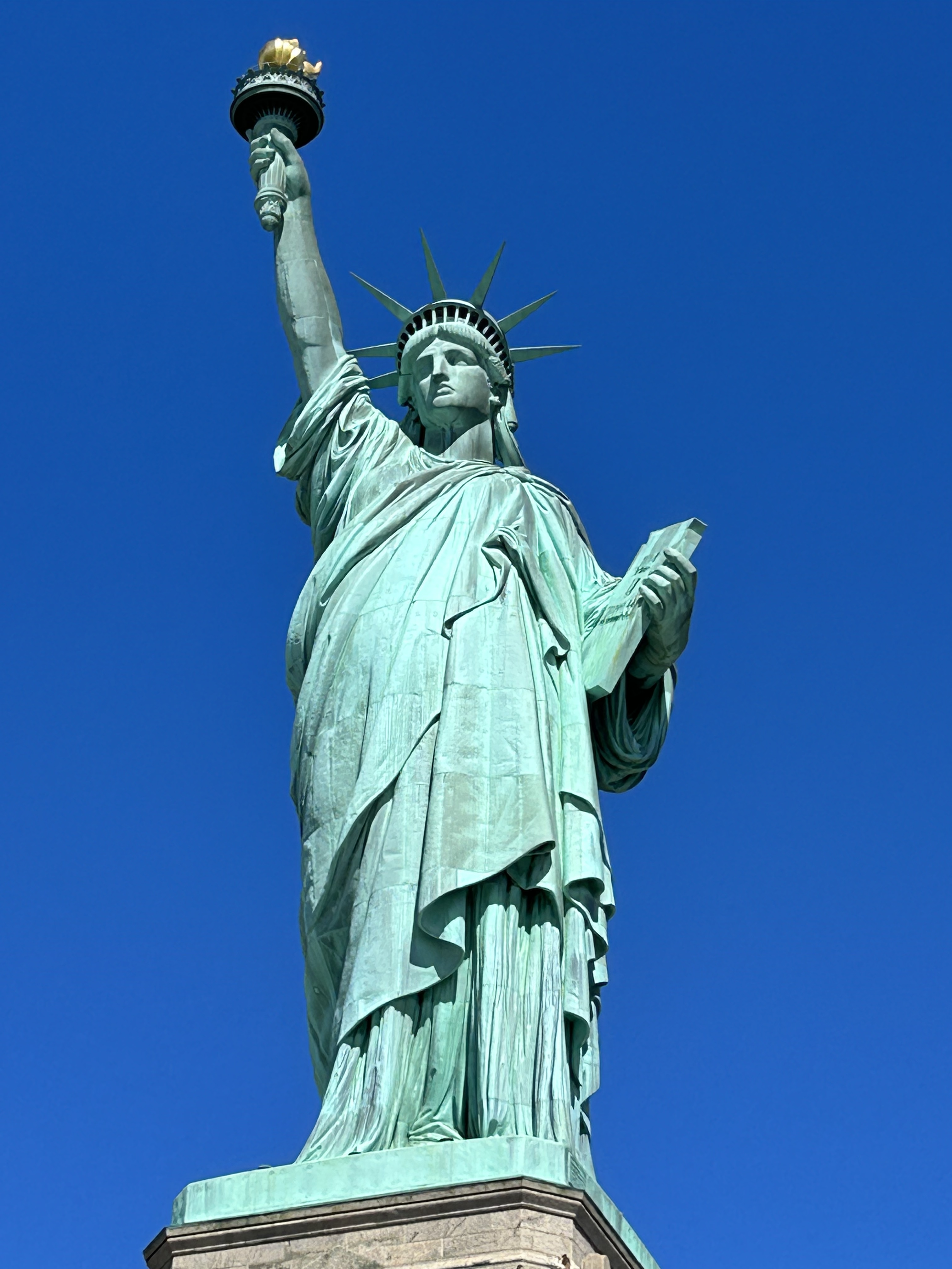
Yes, I took the ferry. No, there is no other way to visit. As a reminder, I have two goals: first to visit the parks without using any carbon fueled vehicles and second to enjoy the parks even if that requires brief carbon vehicle use. So I arrived in NYC by car, walked to Castle Clinton—which is an official Statue of Liberty park office (stamp available)—, and then took the ferry. I wasn’t going to skip it, as it is my favorite iconic park.
I’ve been here before, as a boy, a tourist, with my kids, and now on my own. As usual, some folks visiting from abroad ask me to take their photo, since this World Heritage Site is the highlight of many trips to America. For 62 years immigrants came past the statue on their way to Ellis Island, now a fascinating part of the park. America, an immigrant nation, welcomed them to this huge city in this grand harbor under Lady Liberty’s torch, young and old, rich and poor, from all parts of the globe. Now, together in the city, we share cuisines from around the world, and we learn to overcome the petty ignorance that must never separate us.
“Not like the brazen giant of Greek fame, With conquering limbs astride from land to land; Here at our sea-washed, sunset gates shall stand A mighty woman with a torch, whose flame Is the imprisoned lightning, and her name Mother of Exiles.”
I recently completed visits by EV to all the national park units in the southwest, including 2 in Oklahoma, 4 in Louisiana, 7 in Arkansas, 14 in Texas and 15 in New Mexico. I’ve also visited the southwest biospheres and heritage areas. Here’s a summary of each state with my favorites.
Oklahoma is a beautiful state where many Native American tribes were forced to live and where many famous singers emerged, including Woodie Guthrie, Reba McEntire, Toby Keith, Roy Clark, Carrie Underwood, Vince Gill, Blake Shelton, Patti Page and many more. The Chickasaw Recreation Area is good for nature hikes and borders the fascinating Chickasaw Cultural Center. Washita Battlefield is a difficult site to visit, since it is covers a shameful episode in US history. My report turned into a rant after a park service employee dramatically exaggerated the numbers of white settlers killed in native raids, despite sitting outside the park bookstore which revealed lots of white fear but very few documented killings in historic records. The only affiliated park in the southwest is the Oklahoma City National Memorial.
Louisiana also has important history that must never be forgotten, from prehistoric Poverty Point, to the Cajun culture in Jean Lafitte Park, to the haunting plantations at Cane River Creole and to the birth of uniquely American music in the New Orleans Jazz. The accents, architecture, atmosphere, food, music, scenery, stories and style of the state make it unforgettable. If you’ve never been, go and stay awhile. If you’ve been, go again.
Arkansas styles itself as the natural state—true based solely on armadillos—, but the parks are mostly historic. Early French settlers at the Arkansas Post traded with the natives for furs from the Buffalo River. Later Fort Smith was a critical junction on the Trail of Tears, and Pea Ridge was the site of a key Civil War battle. More recently, Bill Clinton was born here, and Little Rock High was integrated in the face of racism. Even Arkansas’ National Park, Hot Springs, is a throwback to an earlier era. This is one of the few states I hadn’t really visited before starting this quest, but now I know better what an interesting state I was missing.
Texas has a lot of big beautiful parks to enjoy nature: two National Parks, Big Bend (see photo) and Guadalupe Mtns, two recreational lake parks, Amistad and Meredith, along with Big Thicket, Padre Island and Rio Grande. There are also two sites tied to prehistoric man: Alibates quarries and Waco Mammoth. San Antonio Missions predate the US, and Palo Alto Battlefield predates Texas. Fort Davis shows frontier conflict with natives, and Chamizal demonstrates border cooperation with Mexico, as approved by LBJ. Besides all that, Texas has many of the best state parks in the country, with top rate rangers, facilities, activities and scenery.
[Sorry to hop around so much, but I want to wrap up a region]. Last year folks celebrated the 50th anniversary of the river’s designation, but somehow Arkansas allowed a concentrated 6,000 hog feeding operation on Big Creek to pollute the Buffalo River with runoff from tons of pig crap. The resulting increase in algae and e-coli bacteria was damaging water quality in the park significantly. After protests, the hog operation was halted (and paid off handsomely), but local politicians have not been willing to make the ban permanent.
I woke in Tyler Bend Campground all ready to paddle 10 miles of the middle section from Baker Ford to Gilbert (where someone from the General Store would leave my car), but a sudden line of thunderstorms dissuaded me. That storm system killed three people in Texas with tornadoes and brought lots of lightning to this river in Arkansas, so I was glad to hit the road early instead. Pollution from either industrial ranching or fossil fuel burning is taking the fun out of some of my best trips.
Despite rural development—like Branson—, the Ozarks are still very beautiful, and the river is 135 miles of free-flowing nature. Nearby there’s a 100 foot wide natural bridge, one of many alcoves and interesting geologic features in the area that likely caused the French trappers to describe the area as having arches or “aux arcs” (say it out loud).
Americans, being poor linguists and unaware of the remote arches and bridges upstream, have long been confused about the origin of the name “Ozarks”, speculating that the French were talking about natives with curved bows or some bend in the river. This is moronic, as all bows and rivers are curved, so the French explorers would have no reason to use such a useless description. Americans had similar problems in understanding the French name for the Canadian River, which obviously derived from the Spanish word cañada, as the river passes Texas’ Palo Duro, the second largest US canyon. Rather than try to understand foreign languages, Americans assumed the French explorers did not know how to Canada by river.
I figure I climbed Mt Katahdin in Maine over a dozen times as a kid, so I decided just to hike out here to Orin Falls (above), about 6 miles round trip. Surprisingly little has changed in the decades since I last visited. The logging roads are still long, unpaved, bouncy and largely unmarked, and they still have lean to’s for the Appalachian Trail that officially ends on the mountain. The Swift Brook Road one lane bridge is still spectacular, and there are still moose here, wandering out in the roads and ducking into the woods to avoid being photographed. (Definitely a “save this park for offline use” ahead of time if you’re using the NPS app, otherwise you could get lost. My watch kept asking me if I wanted to send an SOS.)
The counselors/ environmentalists who brought us here as summer campers to teach us about nature would be pleased that this is now a national monument, but they would see that not everything has remained unchanged. Man has dramatically altered our climate, so the species here are virtually all in decline. The environmentalists may have won a battle over the logging industry here, but we’re losing the war. On the tour road I stopped at Lynx Pond—one of the most beautiful places I had ever seen as a teenager—, but it was surrounded by dead trees and was much drier than I remember. The slow growing forests of Canada and the northern states are at risk of wildfire, if they’re not burning already. It is not enough to save places like this. We must also save the climate.