Missouri National Recreational River

“O, Shenandoah, I love your daughter,
Away you rolling river.
I’ll take her ‘cross yon rolling water.
Ah-ha, I’m bound away, ‘cross the wide Missouri.”

American folk song

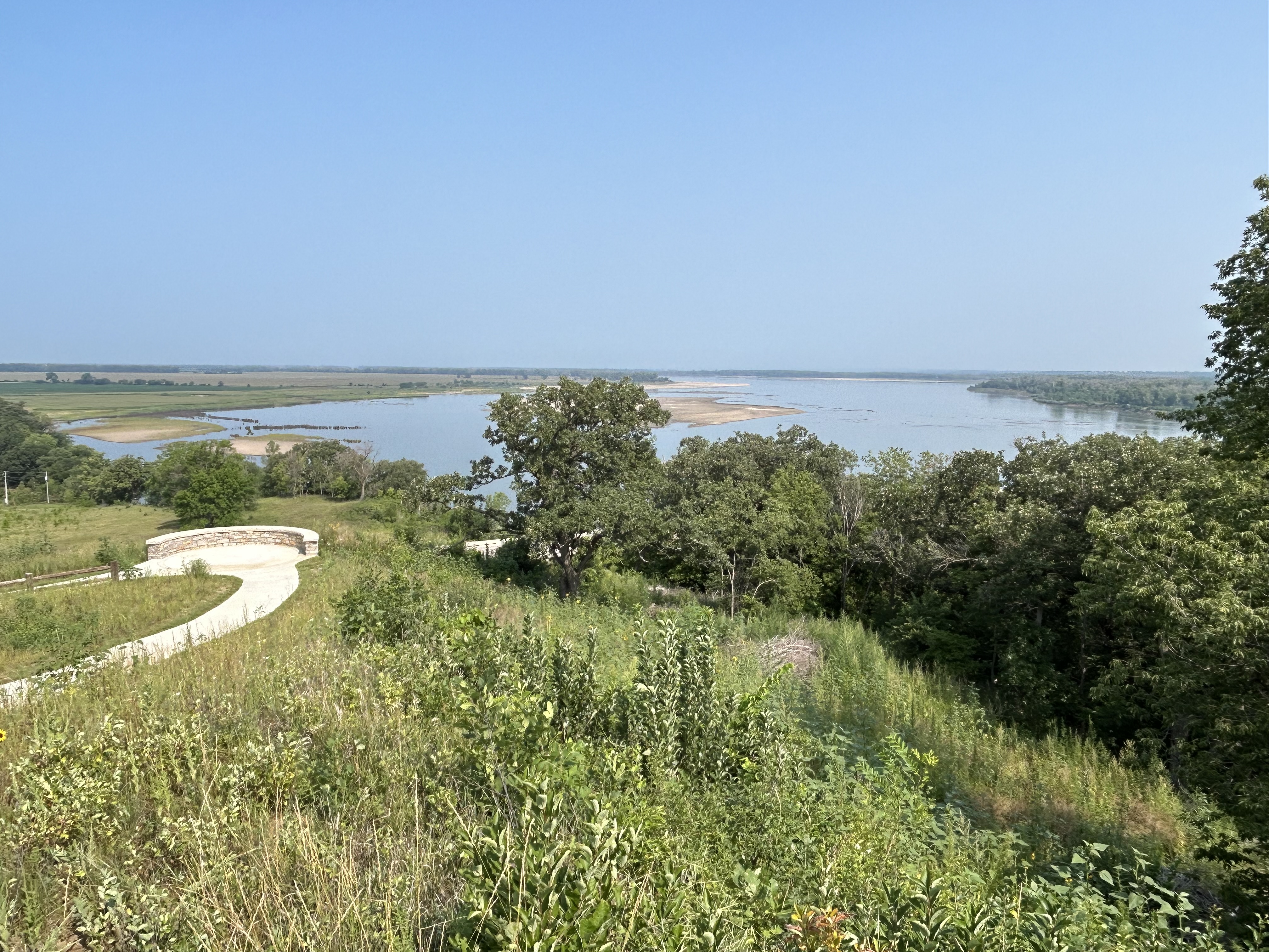
Above looks upstream from the hill above Mulberry Bend in the 59 mile eastern park district, where Lewis & Clark scouted some 219 years ago, along with other places introduced by the Yankton Sioux, one of many tribes that helped the expedition. The Yankton Sioux relinquished most of their land 165 years ago before either South Dakota (right) or Nebraska (left) were states, but they are still considered defenders of Pipestone in Minnesota. Their reservation runs along the north bank of most of the 39 mile western park district, above the confluence of the Niobrara, and they are park partners. Both districts of the park preserve the natural river flow, without commercial traffic, and most power boaters stick to Lewis & Clark Lake in the middle.

Further up the ‘big muddy’ Missouri River, at the confluence of the Knife River in North Dakota, teen mom Sacagawea joined their expedition with her French fur trapper husband and their infant. Like Pocahontas, her story is part of America, and similar stories are part of our heritage. As a child, I loved the song “Shenandoah” but was confused whether it was about the Shenandoah River in Virginia or the Missouri River. Turns out, Skenandoa was an Iroquois Chief, whose daughter was stolen by a French fur trapper and taken away across the wide Missouri River. Romantic stories about natives are part of our cultural heritage, albeit often one-sided. Especially given current tragedies of missing and murdered indigenous women, more effort—and funding—is needed to protect these women and tell more stories from a Native American perspective.

Niobrara National Scenic River

Smith Falls above is the largest waterfall in Nebraska, and it makes a good picnic stop when floating down river. I got a ride with Little Outlaw from Brewer Bridge up to Fort Niobrara and kayaked back. Most people start at Berry Bridge and just float down on giant tubes ‘lazy river’ style, but they miss the pretty part at the beginning. I suppose the nature reserve doesn’t allow alcohol, so that may explain it. Either way, it’s very pleasant, with thick grassy banks, high bluffs, a couple of Great Blue Heron, several smaller waterfalls and no boat engines.

The interesting little town of Valentine is a decent base, with the small visitor center and places to stay. It’s in a well known Dark Sky county, which makes sense since the area is remote & peaceful. There’s a large nature reserve to the south, where I spotted a bald eagle but no bison. With all the space, they should have even more wildlife areas. Somewhere downriver were likely hideouts of bank robbers Frank & Jesse James. There are a number of reservations in the area, especially in South Dakota. There are not many places to charge, so I had to plan and drive a little slower than usual. Be sure to try a Runza—meat pie/ sandwich—if you see the local chain restaurant in one of the larger towns. I recommend mushroom Swiss.

Ross Lake National Recreation Area

Ross Lake is atop three dams on the Skagit River which provides power to Seattle, but it still has some old growth forest near the visitor center which you can hike through on the River Loop and To Know a Tree Trails. Since the park is managed and surrounded by the North Cascades National Park, they run the visitor center. The Gorge High, Diablo & Ross Dams can all be seen in short hikes, and the good news this year after decades of tribal petitioning is that ‘fish passage’ will be added to all three dams! Hydroelectric power is zero carbon, but it must not be at the expense of salmon and other species that we’re driving extinct.

Anyway, I highly recommend those two hikes which total about three miles, and include waysides explaining the different types of trees, their niches in the forest and the natural cycle of wildfire. Another improvement would be building wildlife bridges along the highway & over the river, so that animals like Grizzly Bears could migrate between north and south sections of the park more easily. Well, in any case, Ross Lake extends to the Canadian border and has many paddle-in campsites for folks who rent gear from the resort or somehow portage their kayak around the Ross dam after paddling across Diablo Lake. Seemed like too much work to me to explore an artificial lake, but maybe if I had more time to try fishing, it would make a nice vacation.

Ebey’s Landing National Historical Reserve

In the 1970s locals wanted to prevent a housing development in this historic area, one of the first settlements in Washington, still mostly unchanged from the 19th century. The result was our first ‘historical reserve’ where all landowners sold their development rights in perpetuity to the government (or a private natural conservancy). It makes for an interesting park, where the town is protected from development, but otherwise operates normally. There’s a good museum in Coupeville, and there are three state parks to visit, Fort Casey with a lighthouse, Fort Ebey with nature trails and a kayak launch, and Ebey’s Landing with a section of beach along the Strait of Juan de Fuca.

Jacob Ebey’s blockhouse above is a good place to start a 4 mile hike along the bluffs returning on the beach. Jacob’s son Isaac settled here first, inviting his parents to join him from Independence Missouri, but Isaac was killed by natives in a reprisal for US attacks on native villages. Jacob’s home is open on weekends during the summer, and the staff will tell you the gory details if you ask. The bluffs are not for the feint of heart, but the views of the strait and the mountains are stupendous: Olympic, Rainier and Baker.

Klondike Gold Rush National Historical Park

Seattle is a fascinating city, and this park offers a free walking tour of the Pioneer Square Historic District which teaches you about how the city overcame various challenges to grow. But the focus here is on the Gold Rush of 1897. To just report the numbers, 100,000 people rushed off to find gold, 70,000 bought supplies in Seattle, 40,000 reached the Klondike (mid-border of Alaska and Canada), 20,000 tried prospecting, 300 ‘struck it rich’ finding over $500,000 in gold, and only about 50 didn’t waste their money away digging for more. So the store above represents the only real winners of the rush, Seattle’s merchants. The stories are fascinating, although darkly tragic in many cases.

There’s another section of the park on Bainbridge Island across from Seattle, which is a memorial to the first US citizens of Japanese descent to be forcibly removed from their homes and sent to Manzanar and Minidoka. There is a beautiful cedar and stone memorial wall there along with names of the ‘interns’ and origami cranes, each representing a fragment of hope that a wish comes true. More than in some other places, many of the victims returned to their homes after the war. The main Klondike visitor center in Seattle also has a small exhibit about this American experience.

Lake Chelan National Recreation Area

The Stehekin River in Washington state naturally formed a lake before emptying into the Columbia River, but a small dam was added to raise the water level. To get to the park, you have to take the 1.5 hour ferry ride from the resort town of Chelan (shuh-LAN, rhymes with man), which can be done as a day trip with layovers from 1.5 to 6 hours, or else you have to hike in on the Pacific Crest Trail or some other route, likely overnight through Grizzly territory. The ferry is the best way to get a look at the whole, long lake, including a large stretch of fire damage. I recommend bicycling, but the ferry company doesn’t allow bicycles on some boats, perhaps to aid their bicycle rental business at the arrival dock. Wenatchee Washington is a 45 minute drive south of Chelan, but its hotels are half the price.

Along with Lake Ross, this park is part of the North Cascades Complex, three distinct contiguous park units established simultaneously, so technically I visited all three by EV when I stopped at the main visitor center. The remote village of Stehekin is worth spending some time exploring, as they have a museum, a lodge with restaurant, a couple gift shops, a traditional apple orchard with free-pick-your-own in the fall, and an excellent bakery. Lodging, campgrounds and seats on the ferry do fill up, so reservations are wise. There are also very scenic hikes along the glacial river and above the glacial lake. Due to lack of easy access, the park has a relaxed old-timey feel to it, where folks wave as they pass on the road and people seem to slow down to enjoy themselves. But don’t miss your return ferry, which leaves promptly.

Lake Roosevelt National Recreation Area

A couleé is an old French Canadian word meaning a flow, such as a spring creek that carves out a gully. Roughly 15,000 years ago the giant glacial Missoula Lake melted, ice dams broke and the floods carved a giant gorge here. The Columbia River used to roll on through the grand couleé until the giant dam was built, providing power and irrigation to an extensive area. FDR approved the project, so the man made lake that stretches all the way back into Canada is named after him. The dam has a museum showing old propaganda films about how wonderful dams are. The 12 bands of the Confederated Tribes of the Colville Reservation couldn’t stop the dam, but now they own the lake and co-manage it with the park service. They also hold ceremonies to ask for the return of the salmon.

Fort Spokane—rhymes with ‘man’—has an old school built to force Native American children to be like white kids, and it still hosts Buffalo soldier descendant reunions. The fort is also part of the Nez Perce story, as Chief Joseph and refugees were forced to winter here, receiving some emergency supplies from a trading post named Fort Colville after the governor of the Hudson Bay Company, and some Nez Perce are still here. Many Chinese settled here when there were mining camps, but then they were excluded from immigrating by law, driven out of many northwest communities and massacred in at least a few cases.

There’s a scenic drive up the northeast coast of the lake, past farms, a ferry and a few boat launches. The town of Colville is mostly underwater now, but the mission remains on park grounds. I hiked a few miles looking for the remains of the original townsite of Kettle Falls that was moved to accommodate the lake. There was some fire damage and fireweed blooming, and there’s a large plywood operation nearby. I found the wetlands above between the park service campgrounds and a day use area. There were many geese around here, a few hikers, and I disturbed a large white-tail deer on the trail. It was hot in July, but cooler in Washington state than most of the country.

Ozark National Scenic Riverways

Nature requires pristine conditions to sustain diverse species, and here they exist undiminished. Cave Spring above is fed from Devils Well, a huge underground lake in a Karst cavern 100’ below the surface. The water is so clean and cold that bright green watercress grows in thick clumps underwater. I saw baby swallows above the cave mouth, baby ducks following their mother down the rapids, a river otter, great blue heron and bald eagles. The air was thick with mayflies over the water and butterflies on the wildflowers. Lovely.

Carr’s, aka Current River, offered to provide their equipment for the same price as a shuttle, so I paddled from Akers Ferry to my campground at Pulltite. There’s tubing downstream, but when the water is high enough, upstream is more scenic. There’s an excellent cave tour at Round Spring where I saw cave salamanders, but tickets are limited. The other river in the park is the Jack’s Fork, and there’s a scenic mill at Alley Spring where I saw baby skunks. The largest spring is unimaginatively called Big Spring, and it’s strikingly beautiful with hundreds of millions of gallons of aquamarine water pouring out of the rock daily. Blue Spring is one of the deepest in the world, but I didn’t have time to explore everywhere. This Missouri park is my favorite for kayaking, so I’m planning on returning to paddle another stretch soon.

Big South Fork National River & Recreation Area

The Big South Fork is a 76 mile tributary from the Cumberland Plateau in Tennessee that joins the Cumberland River between Cumberland Falls and Lake Cumberland in Kentucky. The Falls are the second largest east of the Rockies and are the best place to see a moonbow on this side of the planet. Unfortunately, Kentucky has a littering problem, so Cumberland Falls State Park is also a place you will see trash in and along the river.

The Big South Fork looked better when I kayaked from Blue Heron to Yamacraw above (Sheltowee Trace Adventure Resort has a shuttle). Non-native insects killed many pine trees years ago, so the forest has more hardwoods now. Pollution upstream still degrades the water, but Appalachia is recovering from the damage done by coal mining. Blue Heron campground made a good base to charge my car and explore the old mine exhibit there, even though the tourist rail line to town is under repair.

The gorges and remote roads make it difficult to get around, so I recommend paddling if there’s enough water. I saw a young deer and a bald eagle on the river and enjoyed looking up at the cliffs. The hiking is excellent too, and my favorite was hiking under the huge rock shelter behind 113’ Yahoo Falls. There’s also a large natural bridge called Twin Arches. The area is thick with trees, which makes it difficult to see all the geological features of the gorges, but the lush dense foliage gives the river a primordial feel, especially since I saw not a single person while kayaking.

Obed Wild and Scenic River

Lilly Bridge is down to the left from the Lilly Bluff Overlook above. There’s a short trail from the small parking lot, a medium trail down to the bridge and longer trails too. The timing didn’t work out for me, but in theory on weekends you can ask at the Lilly Pad Hopyard near the bridge to help shuttle you to a kayak launch or pick you up. There’s a 2 mile class II trip on Daddy’s Creek and several longer and more challenging trips on the Obed & Emory Rivers and on Clear Creek, all depending on river flow levels, of course, and understanding the limited put in/ take outs available in these protected waters.

The park film showcases the paddling, climbing, hiking and wildlife, with a Tennessee ‘mountain dew’ vibe, and the area feels remote, with hog hunting permitted in the area. Moonshine distilleries must have operated around here for centuries (which may explain why I prefer Tennessee moonshine to their rye whiskey). The US also secretly enriched uranium nearby in Oak Ridge for the Manhattan Project. It’s a lovely area, and I should have budgeted more time to visit.