All Caving Parks, Zero Carbon

I recently completed visits to all the caving parks by electric vehicle. To be clear, with caves running under all 50 states and over 100 parks having some type of named cave, this only lists parks where the primary activity is to visit a cave, almost always on a guided tour.

Subconsciously I become a bit claustrophobic in subterranean spaces, so I compensate by imagining what type of monsters best suit the scene. Rangers who do cave tours are quick to get this humor, although it’s best not to spook other troglocenes—cave visitors—in case anyone is seriously fearful. Below, I describe both the scientific cave category and my own cave creature category.

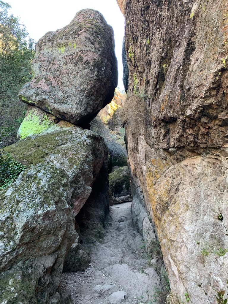
Talus caves are formed when boulders stack up in narrow passages, and Pinnacles in California is the unit to explore these. The large boulders and varying heights made me feel like a dwarf, my first category.

“Caves, they say! Caves! Holes to fly in time of war, to store fodder in!
My good Legolas, do you know that the caverns of Helm’s Deep are vast and beautiful? There would be an endless pilgrimage of Dwarves, merely to gaze at them, if such things were known to be. Aye indeed, they would pay pure gold for a brief glance!”

— Gimli

California’s Lava Beds is the best place to explore different types of lava tube caves, and the skulls and ice-cold rooms are ghostly. Craters of the Moon in Idaho has a similar cave, but obviously that’s more werewolf. El Malpais is more for self-guided, serious spelunkers, but many natural entrances can be seen. Definitely bats.

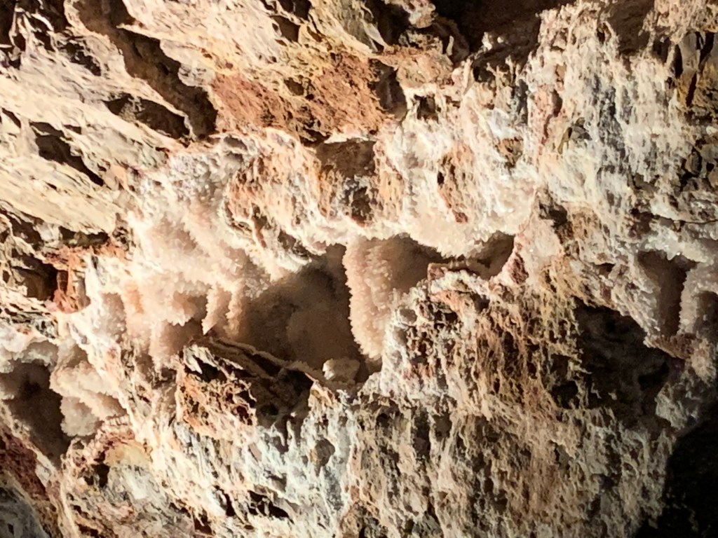
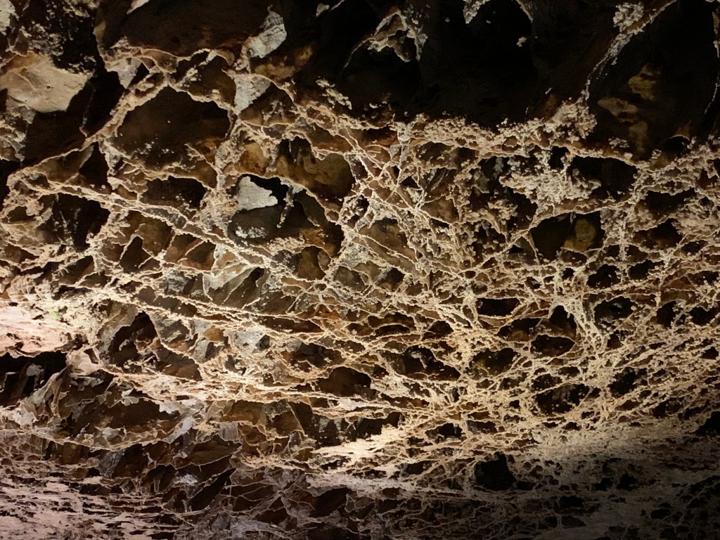
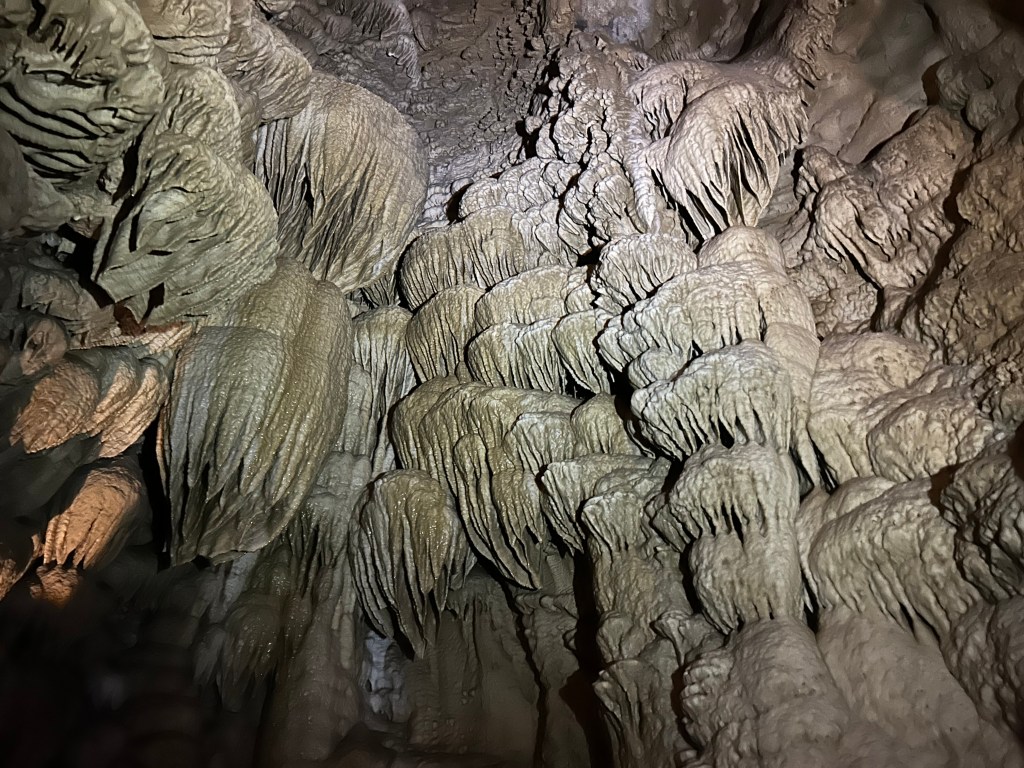
My favorite cave park is Timpanogos in Utah, due to the good condition and variety of speleothems (features created by water). The alien features evoke melon heads. Solution caves, created when liquids dissolve bedrock, are the most common types of cave parks. Carlsbad in New Mexico is the largest with grand speleothems that tower overhead (see photo). Try not to listen for goblin drums coming from the deep. Mammoth in Kentucky is the longest in the world with tunnels fit for lizard people. South Dakota’s Jewel and Wind caves rank 3 & 7 in the world for length, each with different speleothems to see. Also, think Djinn and Minotaur, respectively. Oregon completed my solution cave set, and it’s a good example of a marble cave. Definitely a troll cave.

That’s my complete list of caving parks. Great Basin is not primarily a caving park despite dragonesque Lehman Caves, because the park has such wonderful above-ground scenic views and alpine hiking. Neither is the vampiresque Karst-cave Ozark, since paddling is primary. Nor is archaeological Russell in Alabama. Before going zero carbon, we visited lava tubes in Hawaii, but there’s flowing lava to see. The parks have many more mines, ice, sea or littoral caves, but not primarily for caving.

And always remember to wear completely different clothes and shoes when visiting different caves, so you can help prevent the spread of the lethal white nose syndrome among different populations of bats! I never imagined I’d use all those Chuck Taylors I bought during their bankruptcy underground; perfect in case I need to run from a basilisk.

Lava Beds National Monument

One of the surprising number of caves here, this photo is just inside the entrance of Valentine, a large multi-tube lava cave that’s fun to explore. I also like Skull Cave (named after animal skulls, mostly). It used to have a pristine ice floor at the bottom, but that’s turned dark, uneven and much smaller due to people. Merrill Cave used to have an ice floor large enough for skating, but it melted recently due to global warming, drained into a hole, and opened up a warm air vent. The same sort of thing has happened to at least a dozen other caves here, so you’re too late for the underground ice experience here, forever.

And it’s definitely a cave park. Except for parking lots, few walk around above ground. In 2000 the 85,000 acre Caldwell Fire burned 2/3 of the park, so I’m not sure what’s left to see besides dead trees and, of course, the lava beds themselves, which are black, rough and inhospitable. I recommend going to the visitor center to borrow a large lantern if you don’t have one, otherwise it can be hard to see down the more distant passages. They also have helmets if you’re a smaller, more flexible person who is willing to try the many more challenging caves. And, if you’re wondering what type of caves they have here (Goblin, Lizard or Vampire), I have to say Ghost. The caves have a haunted atmosphere with many strangely cold corners deep in the earth. Enjoy!

Oregon Caves National Monument & Preserve

Since the cave was discovered in 1874, explored and expanded early, humans caused very significant damage to geologic structures making it hard to find beautiful natural features. The ‘cave drapery’ above is at the top of two flights of metal steps up to the Paradise Lost high ceiling above the Ghost Room in the far back of the cave tour. The cave has a stream pouring out from the entrance, and there’s a pretty pool there in front of the Château, which is closed pending renovations. Cave Creek turns into the Wild & Scenic River Styx while underground, the shortest section of river so designated nationally. There are also several pretty hikes above ground, including one to a very large Douglas Fir. Easy to get tickets at rec.gov or at the visitor center in Cave Junction, before driving all the way up to the cave itself. Be sure to check in as soon as you arrive at the other visitor center next to the cave, as they often let folks take an earlier tour when space is available, especially in the morning.

John Day Fossil Beds National Monument

John Day was merely an unfortunate trader who got robbed along the river here, but the event was noteworthy enough that this Columbia River tributary was named after him, then the whole region in Oregon. I first explored the area in 2017 when finding a campsite to observe a full solar eclipse, but I skipped the fossils. I really should have visited the museum earlier.

The John Day Wild & Scenic River flows through a huge volcanic landscape that contains the best Cenozoic fossils discovered in the country. Layers of forests and ash preserved some of the most important fossils used to understand evolution. The Cenozoic is the age of mammals, including the John Day Tiger above and the big entelodont (pig/hippo) behind it on the left. There is a camel skull, a gomphothere (elephant) jaw, mastodon teeth, horns of a giraffe-deer, bones of a short-faced bear previously thought to live only in Asia, rhinos, and some kind of giant dog-bear called a nimravid. There are also fossils of the Dawn Redwood, which still lives in China. The fossils I’ve seen at Fossil Butte, Florissant and Agate are all from periods covered here. If you have time, it’s possible to hike in the three separate remote park units, but the exhibits above are in the Condon Visitor Center in the Sheep Rock unit near the scenic Picture Gorge.

Lewis and Clark National Historical Park

The replica of Fort Clatsop, winter camp 1805-6, above helps imagine the rough conditions for 32 men, a woman, her baby and one dog, when it rained or sleeted 94 days out of 105. Several visitors brought their Newfoundland dogs in a regular event to honor Seaman, the valued, four-legged expedition member.

Jaden and his friend—not yet park service employees—explained the story of the stolen canoe, the eating of dogs and how Sacagawea was purchased and impregnated around age 15 by her ‘husband’ who had other ‘wives’. These facts didn’t make my history book. Jaden’s canoe story was one of the best talks I’ve heard in any national park.

I missed the guided paddle trip, but I walked to Canoe Landing and saw most of the short Lewis & Clark ‘river’ from shore. The pilings in the water here and in much of the Pacific Northwest are old logging organizers.

The park also includes various nearby sites visited by the expedition, including Washington state’s Cape Disappointment—misnamed by someone who mistakenly thought the bay too large to be the mouth of the Columbia River. A Japanese sub briefly bombed Fort Stevens on the Oregon side. The charming seaside town of Astoria, once famous for furs, canneries and The Goonies, makes a good base to explore with some good restaurants and reasonably priced hotels.

Fort Vancouver National Historic Site

Portland Oregon has always confused me geographically. What kind of port is over 100 miles from the coast on a tributary of a major river? The history of this site explained it. George Vancouver, a British explorer who sailed with Captain Cook, explored the Pacific Northwest coast in the 1790s, and both the both the huge natural harbor in British Columbia to the north and this deep water site to the south on the Columbia River were named after him. Vancouver Washington was perfectly located at the confluence of the Willamette River to be an inland trading post still reachable by ocean vessels. The Chinook have long lived here and traded with other tribes, regularly traveling hundreds of miles by canoe. When the Pacific Northwest was British, this was all one territory from Sitka Alaska to San Francisco. Portland was built later as Vancouver’s port. When it became US territory, Oregon and Washington states split the growing city here on the Columbia. As the Willamette (Wil-AM-it) Valley developed in Oregon, Portland became the city and Vancouver became the tax-dodging suburb (lower income taxes in Washington within easy bridge distance to lower sales taxes across the river in Portland).

The British Hudson Bay Company built its corporate territorial headquarters here in 1825 to capitalize on the fur trade with tens of thousands of local Native Americans and a great many more via their ancient trade routes along the coast, up the rivers and deep into the mountains. The British contracted with many French fur traders who typically married natives. British ships brought workers from Hawaii after rounding Cape Horn. The fort (reconstructed on location above) was the center of a thriving cultural melting pot that developed its own language and challenges. Unfortunately, many natives died of disease, particularly malaria, which the ‘gentlemen’ who lived in the fort knew could be treated with Quinine, which they had in limited quantities. The company man in charge, Dr McLoughlin, was married to a biracial woman, and he was violently furious when newly arrived missionaries spoke derogatorily of her.

McLoughlin nevertheless extended credit to the many destitute white settlers who arrived on the Oregon Trail. He lost money, was forced to retire, became a US citizen and is now considered the ‘father of Oregon’. His house is part of the site south of Portland. White settlers took over and made the state ‘whites only’ by law until 1926, prohibiting others from property ownership etc. It’s worth reflecting honestly on this history when considering the recent Supreme Court decision against affirmative action: white ‘pioneers’ gave themselves every legal and economic advantage possible, from slavery, to the Rogue River Wars against natives, to ‘whites only’, to the Chinese exclusion act, and to taking property during the Japanese internment. It’s shameful that the Court ignored the long history unfair privileges given to white people—many whose families benefited over two hundred years from stolen land, labor and opportunity from so many people of color—and decided against providing a few seats in college in order to enrich the diversity of education for all students.

Nez Perce National Historical Park

The visitor center in Idaho is on a hill above where the Lapwai Creek flows into the Clearwater River, which joins the Snake River a few miles downstream in Lewiston. The river banks were an excellent place for salmon, berries, edible flowers, and game, and the Nimiipuu used to arrive in the fall and stay through winter. By summer, they would be hunting up in the hills, forests & mountains. French trappers called the tribe Nez Perce or ‘Pierced Nose’, although that wasn’t a traditional tribal practice. When Lewis & Clark passed through, the Nimiipuu assisted the expedition and helped them make canoes. When the missionaries and other settlers arrived, they were forced to change. Many tried desperately to compromise and adapt. After the nearby Whitman mission ended in a massacre, racist demagoguery fueled far more excessive violence across the west, bringing the US military, war, exile and restricted reservation life, including here around the Spaulding mission, pictured circa 1900.

The affiliated Nez Perce National Historic Trail, which marks the flight of the tribe from the US Army, is now part of the broad official Nez Perce NHP, including Big Hole in Montana, a refuge near Lake Roosevelt, the White Bird & Clearwater Battlefields, through Lolo Pass, Yellowstone, Billings and up to Bear Paw Battlefield. Over the years, I’ve visited these places on roadtrips, read several of the books, from I Will Fight No More Forever to Chief Joseph & the Flight of the Nez Perce and pondered the mistakes and tragedy. There is simply no excuse for breaking treaties, stealing land, or killing defenseless people, including women, children, the elderly and infants. When leaders take advantage of popular anger to focus attacks against a community, the result is often far more evil than any original sins. I encourage you to learn more, since the problem of demagoguery is still with us.

But the Nez Perce tribe is still here with us, like the flowers they used to cultivate here. They are re-learning the language that they used to be punished for speaking. They self-govern, petition the US government, sing songs, dance, teach their kids to gather plants, hunt, fish and carry on their cultural traditions and exercise their treaty rights. The lessons of their forefathers and their oral traditions continue to be remembered, spoken aloud and passed down to future generations. The park preserves petroglyphs, artifacts and sites of mythology. Their culture is vibrant and contributes a valuable perspective to all of us. They are not doomed to be permanent prisoners of tragedy, and the park film here is a refreshing reminder of the resilience and life of their culture and of the human spirit.

Whitman Mission National Historic Site

The Cayuse had heard from the east about what happened to natives after settlers arrived, so they predicted death, loss and suffering were on their way. The Whitman missionaries left in 1836, five years before others started arriving overland in Oregon. They were allowed to start a farm here, and with the fervor of the second awakening, they preached that the Cayuse were going to hell after death unless they adopted Christianity. As it turned out, gathering newly arrived settlers and native converts in church weekly to break bread and sing songs together, helped spread diseases like measles that killed most of the native population. So the Whitmans were sort of correct, except for the order: first they adopted Christianity, then they went through hell before finally dying.

Unfortunately for the missionaries, the natives had a tradition of killing bad medicine men. Now, much has been written of the Whitman massacre (especially by the other missionary Spaulding who settled nearby with the Nez Perce), but imagine if immigrants come to your town and demand that you copy their strange new ways and beliefs, with threats if you did not. Many more immigrants arrive each year, talk with the missionary doctor, take over and spread disease. When the doctor treats his own people, they usually survive, but when he treats yours, they die. How many of your friends and relatives would die before some angry grieving parent would try to kill the doctor? I’m not excusing criminal behavior based in ignorance, but similar senseless vengeful murders still occur today.

When half of the Cayuse had died of disease, a group of natives killed Doctor Whitman, his wife and 11 other men. There’s a memorial on the hill in the photo above. 5 natives were later found guilty and hung. The mass murder was a terrible crime, but the response was just short of genocide. For the next 12 years, the Cayuse and many other natives in the territories were hunted down by militias and by the military, driven from their lands, harassed and in many cases slaughtered, including women, children and the elderly. When the dust settled, most of the remaining natives were on small reservations with a few escaped to Canada. For every white person killed, hundreds or likely 1000s of natives died. More lost everything they owned, including their freedom, despite not having anything to do with the original conflict or the Cayuse.

St. Croix National Scenic Riverway

Defining much of the border between Minnesota and Wisconsin, this river and its tributary the Namekagon were among the first rivers protected by the Wild & Scenic Rivers Act, supported by Walter Mondale and many other locals 55 years ago. The forest was quickly and heavily logged 150 years ago, but the water remained clean. Even though there are several dams, including a hydroelectric one at Taylors Falls, the river is much healthier than most, especially the upper St Croix. Below the dams, near the Mississippi, there are power boats, a power plant and non-native mussels, but higher up there are dozens of native mussel species, various fish, otters, bald eagles, kingfishers, great blue heron, several different colorful warblers and more.

The forests have regrown too, so it can be difficult to get a decent view of the river. The photo is from the Minnesota state park ($5 to park) below Taylors Falls, and it has a a canoe & kayak rental, picnic tables and camping. Nearby you can catch the scenic riverboat pictured that offers views of the basalt cliffs shattered by glacier melt. I’m going to have to return a third time, since my first trip was during spring floods and this summer during extreme low water. I believe the best views will be paddling the upper St Croix from the Namekagon confluence to highway 70, but I need good conditions for the rapids.

The Wisconsin parks are $11 to park with very similar views and features. There’s also a waterfall at Osceola, but the bluff trail there is now called the Falls Bluff Trail Loop, or the Cascade Falls Trail or the Eagle Bluff Trail or maybe the Simenstad Trail or the Osceola Rivertown Trail, but not the Osceola Bluff Trail like the park map says. Fortunately, you can also see the waterfall from the road, and the Watershed Café is quite good.

Mississippi National River and Recreation Area

The tiny tributary (above) of the Mississippi River is Coldwater Spring, one of the few parcels of land the park service owns here except for islands. Buildings were removed, plants planted, and the birds and butterflies have already returned. A mink was sighted a few days ago. Having a good spring near the confluence of the Minnesota River made it ideal for an early trading post. Eventually the twin cities of Minneapolis and Saint Paul arose, but, even though you can hear traffic, the spot is mostly wildflowers, prairie grasses, and old Live Oaks.

The trail will be ready in September, so I wasn’t able to walk down to the floodplain to see the Cottonwoods here, but they’re visible in other locations. Nearby are the Minnehaha Falls, named after Hiawatha’s love in Longfellow’s 1/2 imagined and 1/2 native lore mashup epic “Song”. Hidden Falls / Crosby Farm and Lilydale-Harriet Island / Cherokee park partner sites are also recommended for views and other activities. The main visitor center is in the science museum and has mainly kid-friendly exhibits.