Devils Postpile National Monument

The park is only accessible for zero carbon travel for a few weeks after the required shuttle service ends (mid September) and before the road closes (early to mid October). Shuttle buses are useful for reducing carbon pollution, but unless they’re sustainably fueled, they’re out of bounds to me. Red’s Meadow Cafe was still open, but the resort was closed when I arrived late September.

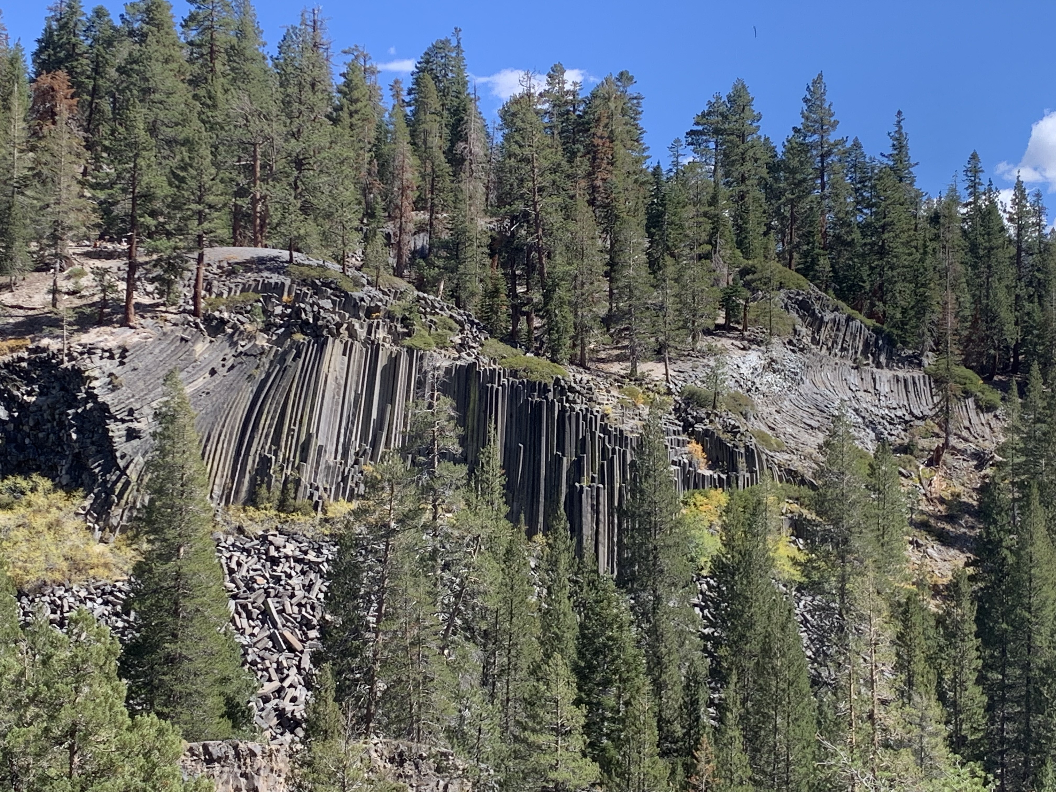
Since both the John Muir and Pacific Crest Trails run together through the park, I recommend you hike in a loop around the base of the broken basalt columns, across one of the two bridges across the Middle Fork of the San Joaquin River, along the combined JMT & PCT trail ridge where I got the photo, and back across the other bridge. There are also pretty waterfalls at both the north and especially south ends of the monument, but be careful hiking as the park is at around 7,500 feet in altitude up near the Mammoth Mountain ski area. There’s also a trail up through the trees to the top of the columns, which were formed 80,000 years ago when a diabolically molten lake cooled and cracked deeply in hexagonal and similar shapes and which were revealed by glaciation 15,000 years ago. Enjoy!

Effigy Mounds National Monument

On the Iowa side of the Mississippi River looking across from the high bluffs toward Wisconsin, there are over 200 hundred mounds, round, linear, bird and bear shaped. They are in clear lines straight out from the river, and they date back roughly 1,000 years, evidence of cultural traditions that continued for hundreds of years. Although these sites typically do not make the connection, there are similar sites along the Mississippi and other rivers at overlapping time periods with evidence of trade between them. Bird symbols in particular are found in both modern and ancient Native American culture. Many similar mounds were flattened and plowed under after the land was stolen.

The hiking here is excellent, with many overlooks, including Fire Point above and Third View which looks upriver. The hillock to the right of the path is one of the mounds, first in a long line into the woods. A pair of hawks soared high above. If you can make it a few miles, your chances of seeing deer and other wildlife improve. Since it is a sacred site, please stay on the trails and do not walk over the mounds.

Harpers Ferry National Historical Park

Since each park is unique, I would never be able to say which is my favorite. But this one is.

Here, at the confluence of the Shenandoah and Potomac Rivers, in 1859 the abolitionist John Brown led 18 men to capture the armory, arsenal, and rifle factory here, killing three men, freeing slaves and taking the town’s leaders captive, before being captured by Col. Robert E. Lee and martyred after a brief trial, becoming the first person executed for treason in America. Brown believed he was right, did not intend for anyone to die and argued at trial that “had I interfered on behalf of the rich, the powerful… or any of that class… this court would have deemed it an act worthy of reward.”

Native Americans lost this land to European settlers during the 16th and 17th centuries. Washington explored the area for his canal project and recommended an armory be built here. The armory supplied Lewis & Clark’s expedition, and the arsenal supplied weapons for the Civil War. During which the town changed hands eight times including the destruction of the arsenal, the capture of 12,500 Union soldiers by Stonewall Jackson and the critical resistance to the confederate army marching on DC. Major Delaney, the only African American field officer in that war, came from here, alongside many USCT recruits. Frederick Douglass and W.E.B. DuBois organized and lectured here, where the Freedman’s School and Storer College educated the descendants of slaves.

Thomas Jefferson stood on a rocky overlook and said “this scene is worth a voyage across the Atlantic.” The mountains, rocky cliffs, rivers, swamps, and floodplains here support diverse wildlife, including three species of hawk, a harrier and the bald eagle. There are over 20 miles of hiking trails in the park, including part of the Appalachian Trail (park & hike). And the tavern in town serves a draft amber ale called Almost Heaven.

“Almost heaven, West Virginia
Blue Ridge Mountains, Shenandoah River”

John Denver

Appalachian National Scenic Trail

It was hiking on the trail in New England as a boy that I got the idea to visit as many national parks as I could. Some of the counselors were discussing their trail names and talking about the best natural places to visit in the country. I never forgot that feeling of walking deep into nature, exploring, seeing wildlife, jumping into a swimming hole and imagining traveling to even more beautiful places. It took a long time, but I’m finally fulfilling part of that dream.

I don’t know if I have it in me anymore to hike the whole trail, but I would love to try. The relief map (above) in the park-partner Appalachian Trail Conservancy visitor center in Harpers Ferry gives you a sense of both the distance and the many mountains that must be summited. But I wasn’t about to take a gas-polluting bus to get from the Harpers Ferry visitor center parking lot into town, especially when I could walk a couple miles of the AT to get there. And I would recommend hiking the trail, even just a small section, if you can. For the adventurous, the expert suggested thru-hiking the trail in two sections, from Harper’s Ferry in the spring north to Katahdin in Maine and then from Harper’s Ferry south to Springer in Georgia in the fall.

Below, I’ve listed the units either on or next to the trail.

Chesapeake and Ohio Canal National Historical Park

The highlight of the canal has to be the tavern, lock and boat in Maryland across from the Great Falls Park in Virginia. It’s only a short walk here to a view of the falls from the ecologically important Olmsted Island, which was preserved by the son of the famous landscape architect. There are limited boat rides on Saturdays until mid October. Williamsport has a much more elaborate and functioning canal boat exhibit, but their rides are currently suspended. If time allows, I would like to come back next year to bike along the multi-state canal route.

Timpanogos Cave National Monument

The cave is famous for its helactites, the squiggly ones that seem to defy gravity. To see them, I’d recommend a reservation or getting here early (open at 7am), as they do sell out. Then, walk up the switchback trail for 1.5 miles, and be careful not to wander off the near vertical drops while you gawk at the stunning views. The gap between the mountains appears to be deeper than it is wide, and there’s a river flowing through a forest at the bottom along with the road. Don’t mind the many hikers. They’re probably just out for exercise, as one lady told me her friend had climbed it over 100 times. And I suspect they exercise regularly with mountain goats here, since I also saw two moms carrying two kids each with more in tow.

The regular tour is ranger led and includes three sections of cave. The middle section has a crack in the ceiling which has dripped water for ages to create the amazing structures: flowstone, soda straws, popcorn, bacon, small crystals, stalactites, stalagmites and columns, in a variety of colors. We also saw a party of explorers with caving equipment entering small passages, which is another tour option for the skinny and flexible. This is my favorite cave.

Theodore Roosevelt National Park

Certainly the highlight of my trip, the three units are connected by the Little Missouri River, which is the south unit oxbow on the left. The south unit also has bison, wild horses, a painted canyon, petrified logs, a prairie dog town, badlands, a replica of Teddy’s cabin, a ranch, camping, and lots more. The north unit has even better oxbow views on one of the best hikes I’ve ever done: Caprock Coulee 4 miles. Even the tiny Elkhorn Ranch unit, hemmed in by cattle fences and pumpjacks, had a pair of whooping cranes to amaze me. I’m honestly struggling for superlatives. Teddy used the phrase “grim beauty” which gets at the serious nature of the park. This is one of my favorite national parks. Click here for more Teddy Roosevelt sites.

I would like to spend a week up here and ride a horse, but I’m already in Montana. For EV travelers who want to see all 3 units, I recommend charging overnight in state campgrounds before & after. There’s one next to the south unit and another not too far from the north.

Badlands National Park

I took the photo just a minute after arriving at Cedar Pass campground. Much of the “original badlands” scenery is down in canyons, but these peaks are more photogenic. The long loop road is worth it, and the park allows even off-trail scrambling. The ranger talk was excellent, and I learned that the town of Wall (and famous Wall Drug Store) is named after the barrier that the park’s landscape presents to travel.