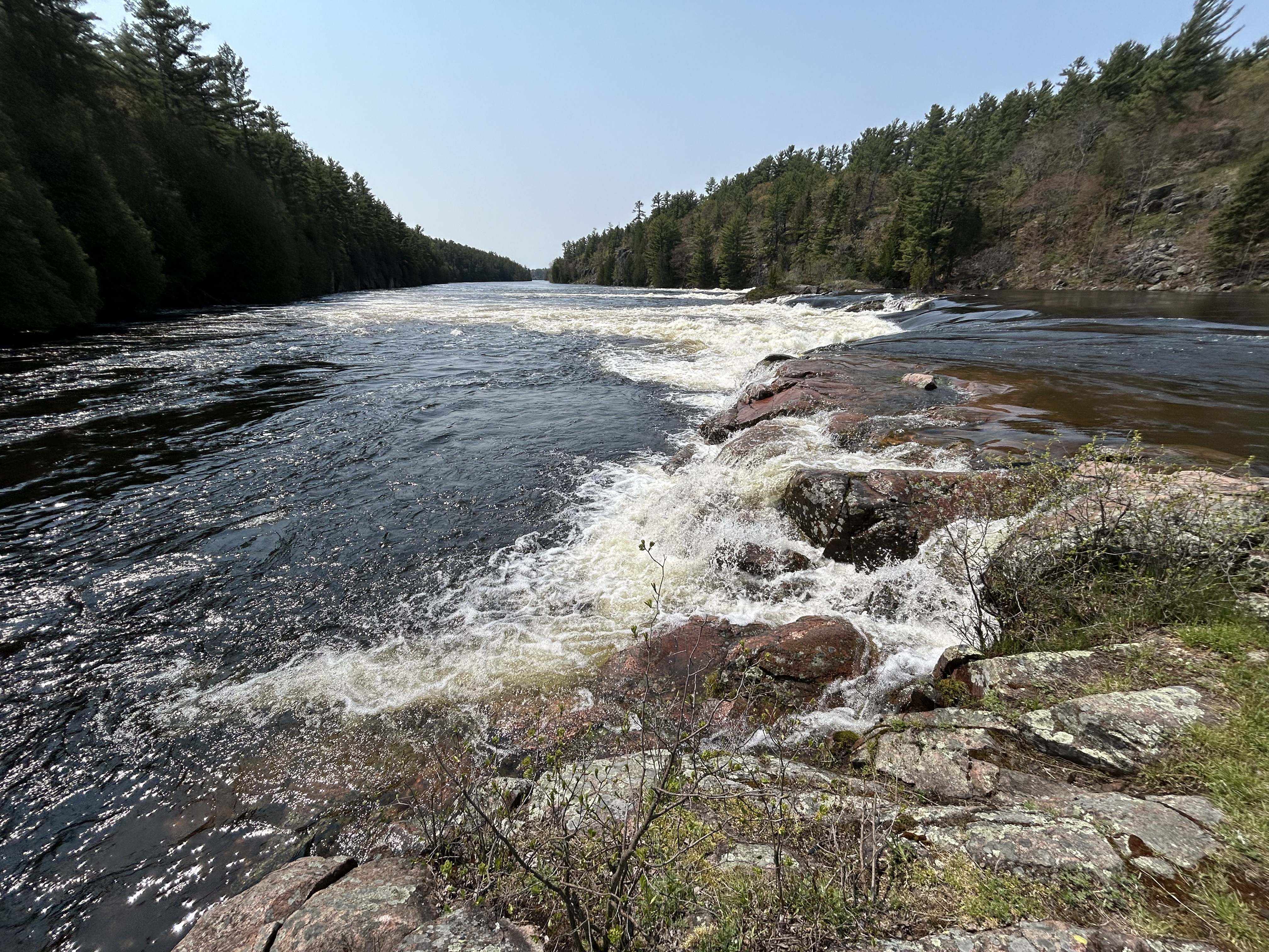
Georgian Bay is almost as big as Lake Ontario, but it’s still just considered a bay of Lake Huron. The Niagara Escarpment separates the bay in the form of the Bruce Peninsula and Manitoulin Island. Above are the Recollet Falls on the French River at the north end of the biosphere. Most of the famous explorers of Canada passed this way: Brûlé who lived with the Huron as a teen around 1610, Champlain and Mackenzie, among others. Radisson and his brother-in-law may have been the most consequential, as they realized the economic potential of Ojibwa fur trading canoe routes. Unlike the licensed voyageurs, the pair were outlaw traders, known as coureur des bois, ‘runners of the woods’. When the French declined to support their venture, they turned to the English and formed the Hudson Bay Company.
The south end of the biosphere is at the Severn River, where there’s an impressive canal/ boat-railway system for transiting small craft between Lakes Huron and Ontario. Much of the biosphere belongs to the Anishinaabek people, who call it the Mnidoo-gamii, the ‘spirit of the lake’. The lakeshore is well protected, remote and home to a great many species. As ages ago, boat is still the best way to explore this ‘30,000 islands’ area. Still, I managed to spot two black bears just outside the park where I hiked to the falls above. Fortunately I didn’t see any of their rare local rattlesnakes. Northwest of Georgian Bay, on Manitoulin Island, I saw a bald eagle, six sand hill cranes, and a variety of smaller birds. Georgian Bay is a lovely area, and I’m glad it’s protected.
I recently completed EV visits to all five NPS affiliated sites in the Midwest, which were interesting and educational. Wisconsin is a good place to learn about drumlin hills, kettle lakes and moraine at the various park interpretive centers in the Ice Age National Scientific Reserve. The story of Father Marquette’s voyages and the Chicago Portage stretches through several states. Toledo Ohio keeps history at the Fallen Timbers Battlefield and Fort Miamis (see the fort’s footprint above) on the banks of the Maumee River. And Nebraska protects Chimney Rock on the pioneer trails.
Much more coming soon, including three national parks, biospheres, and heritage areas as I wrap up the Midwest region. And I reveal my secret project. Stay tuned!
Way back in 1673, French explorers Louis Jolliet and Father Jacques Marquette were preparing to travel east to return to Canada after exploring the Mississippi River. Though the statue wrongly implies that Marquette pointed out the route, their Native American guides showed them a shortcut, by traveling up the Illinois River and portaging (carrying) their canoes between some muddy lakes to Lake Michigan. Marquette realized that if there were a canal, weeks-long journeys would reduce to days. 175 years later, the government finally built the canal, and suddenly, Chicago became one of the largest and most important transportation hubs and cities in the US.
The site itself is in a small woods between the Des Plaines and Chicago Rivers, and as part of Chicago’s river greenways, it’s managed by Cook County in affiliation with the NPS. The canal itself is 100 miles long with a bike trail, and there is a 1 mile canal boat tour in LaSalle at the Illinois River end. A non-profit association runs summer boat tour as well as the larger Illinois and Michigan Canal National Heritage Area, which includes Chicago Portage, the Pullman National Historical Park and promotes tourism to neighboring communities and parks. The canal is a key part of the Great Loop, a boat trip around the eastern part of the country, from the Great Lakes down the Mississippi, around Florida, up the eastern seaboard to New York, and back to the Great Lakes.
There are only three NHAs in the Southwest Region, two in Louisiana and one in New Mexico. While not official park units, they are uniquely interesting and beautiful areas to visit.
Atchafalaya National Heritage Area in Louisiana runs from the Natchez NHP and Natchez Trace NST, down past Lafayette and Baton Rouge, to the Gulf Coast west of New Orleans. Culturally, the focus is on the Acadians or Cajuns. 150 years after settling Acadie, now Nova Scotia, the French speaking Acadians were expelled by the British beginning in 1755. Longfellow wrote his epic poem Evangeline about the tragedy. Skilled fishermen and wetland farmers, many settled in French Louisiana, growing rice, beans and catching crawfish. They mixed with Native Americans, slaves, freed blacks and other immigrants, but kept their French roots. The French pirate Jean Lafitte, a successful smuggler in the area, was captured, but offered to help the Americans in the War of 1812 in return for his freedom. Lafitte knew the swamps (waterlogged land) and the bayous (shallow waterways through the swamps) expertly, and Andrew Jackson employed him as his aide-de-camp. Lafitte also provided troops, cannon and ammunition. The Battle for New Orleans was won, and Jackson was credited as the hero. Lafitte was likely responsible for defeating the superior British forces, but he received no credit from the US military, just a pardon. But the Cajuns still thrive here, and their history and culture is preserved at the Jean Lafitte NHP & Preserve, which includes three different Cajun Cultural Centers in the NHA. Their music, Zydeco, is from the French word for beans, “Les Haricots” (say it fast). And Breaux Bridge, of course, is La Capitale Mondiale de l’Écrevisse, or the Crawfish Capital of the World.
Cane River National Heritage Area is the other NHA in Louisiana, and it is best known for the well preserved plantations of the Cane River Creole NHP. However, the whole river area from Natchitoches between the national forests, down past the plantations is fascinating. This is the northern terminus of El Camino Real de Los Tejas, one of the Old Spanish Trails that runs through Texas, and there are state historic parks highlighting the forts and cultural sites that predate the Louisiana Purchase. I try to get lost at least a few times every visit to Louisiana, as there’s always something surprising to find and plenty of delicious food!
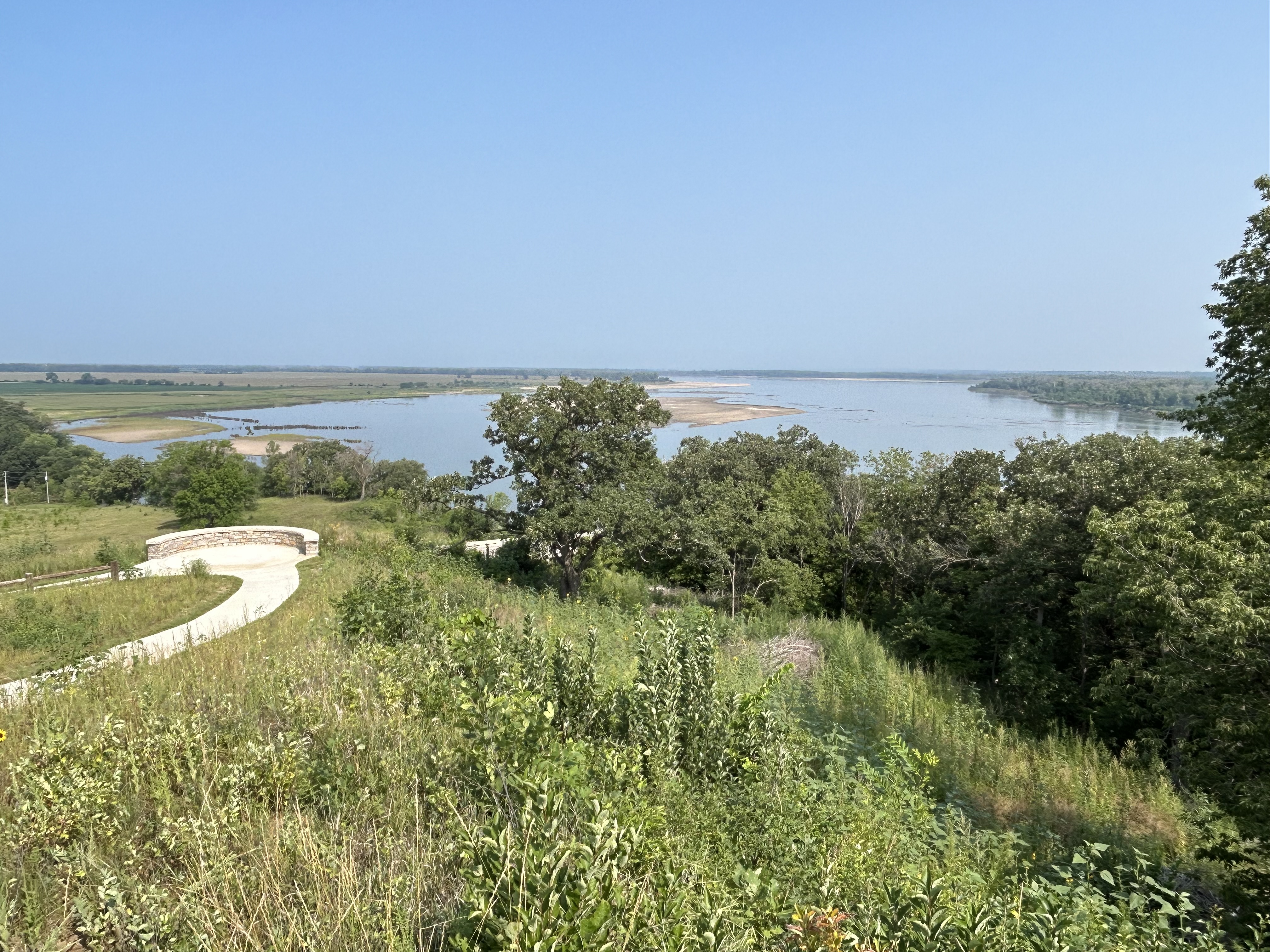
The Northern Rio Grande National Heritage Area in New Mexico is at the crossroads of both the ancient and old west. El Camino Real de Tierra Adentro connects Santa Fe to Mexico City. The Old Spanish Trails connect Santa Fe to Los Angeles, and the Santa Fe Trail connects Santa Fe to St Louis. Route 66 goes right through town. And before they were Spanish, they were all Native American trading routes. The natives once expelled the Spanish during the Pueblo Revolt, planned at Pecos. There are caves and Petroglyphs showing where people camped. Bandelier with its tall ladders to cliff dwellings is also in the NHA. But it’s not just history. Taos Pueblo (above) is still occupied today, continuously for over 1,000 years. All this I had seen, but then I got lost again, taking an improbable route through the mountains towards the headwaters of the Rio Grande in Colorado. And there are canyons, gorges, wild and scenic rivers, Georgia O’Keefe’s ranch, more cliff dwellings & petroglyphs, and even more storied trails. Some of my most memorable scenes of America are on the drives between official sites, intangible culture, storied heritage, true wildlife, and sheer beauty on the road not often taken.
John Smith was an explorer, adventurer and leader whose stories, maps and detailed descriptions of life in the ‘New World’ helped convince many early immigrants to cross the Atlantic to the colonies. As a young soldier John Smith was held captive by the Turks, as a leader of the first British colony he was captured by the Powhatan, and as an explorer in New England he was held hostage by French pirates. Respectively, he escaped, was saved by Pocahontas (more than once), and negotiated his own release. He learned the local native language, forced upper class colonists to labor for food, and didn’t return to England until after some gunpowder exploded in his canoe.
The affiliated “trail” covers the rivers that flow into the Chesapeake Bay, but to be clear, Captain Smith only explored the rivers as far as he could navigate in his exploratory small ship. His maps show the bays, not the lengths of non-navigable rivers shown as part of the trail. The trail extends far up various rivers, but neither Smith nor crew went to most of those places. I was confused on this point until the Susquehanna visitor center expert answered my questions.
The trail extends from Hampton Roads near Fort Monroe where the bay opens to the Atlantic, up the James River past Jamestowne, past places that would later be Grant’s HQ in Petersburg, the Confederate Capital of Richmond, and across the Appalachian Trail and the Blue Ridge Parkway where the James becomes the Jackson River. The trail goes past Yorktown and up the two rivers that form West Point. And the trail goes up the Rappahannock River past Fredericksburg.
Smith also later explored and named much of New England, but this Chesapeake trail alone is certainly worthy of exploration. Someday, I’d like to return and see it by boat! And speaking of hopping around the country, Monday posts are going to cover National Parks on the West Coast, while Thursday posts will range more widely, covering more trails across the country. Enjoy!
The replica of Fort Clatsop, winter camp 1805-6, above helps imagine the rough conditions for 32 men, a woman, her baby and one dog, when it rained or sleeted 94 days out of 105. Several visitors brought their Newfoundland dogs in a regular event to honor Seaman, the valued, four-legged expedition member.
Jaden and his friend—not yet park service employees—explained the story of the stolen canoe, the eating of dogs and how Sacagawea was purchased and impregnated around age 15 by her ‘husband’ who had other ‘wives’. These facts didn’t make my history book. Jaden’s canoe story was one of the best talks I’ve heard in any national park.
I missed the guided paddle trip, but I walked to Canoe Landing and saw most of the short Lewis & Clark ‘river’ from shore. The pilings in the water here and in much of the Pacific Northwest are old logging organizers.
The park also includes various nearby sites visited by the expedition, including Washington state’s Cape Disappointment—misnamed by someone who mistakenly thought the bay too large to be the mouth of the Columbia River. A Japanese sub briefly bombed Fort Stevens on the Oregon side. The charming seaside town of Astoria, once famous for furs, canneries and TheGoonies, makes a good base to explore with some good restaurants and reasonably priced hotels.