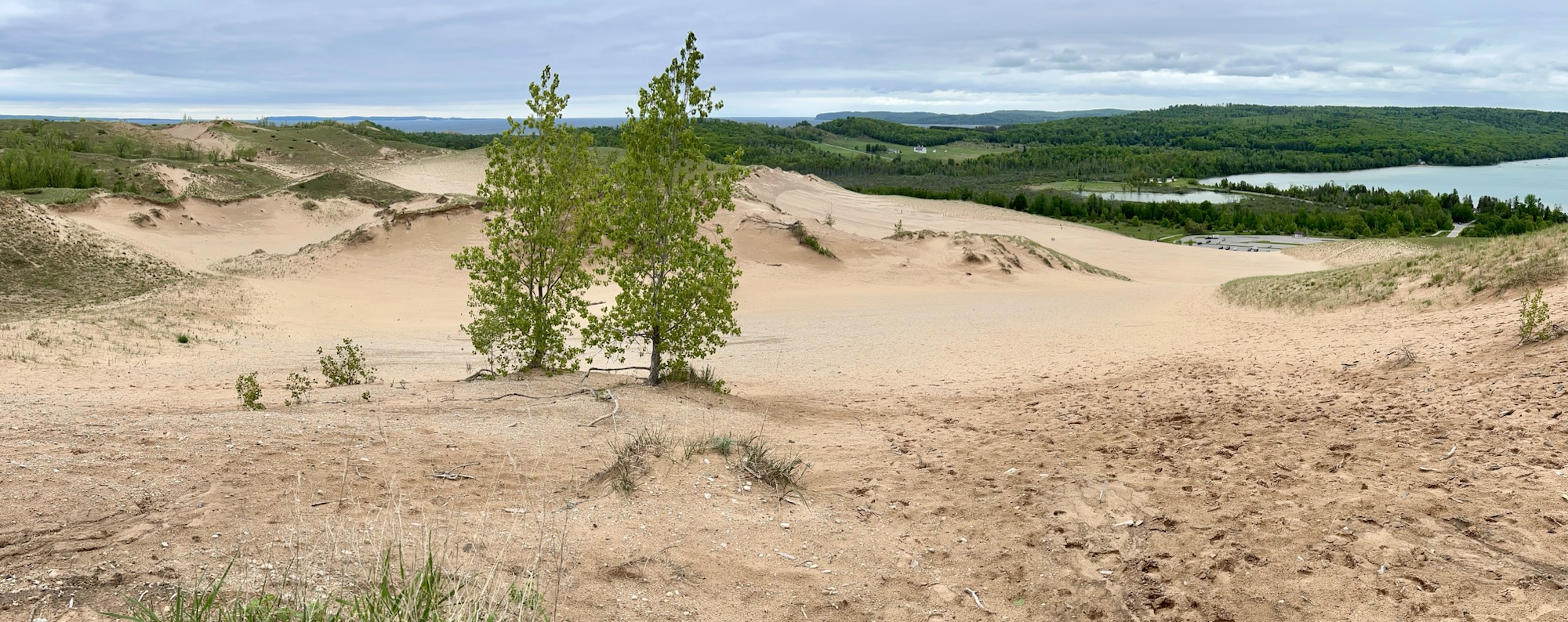
The small lake on the right is Glen Lake, and Lake Michigan is at the top left. If you zoom in to the right, you might see tiny people climbing the middle dune from the parking lot. I got up to this vast view on the pleasant Cottonwood Trail (less than 2 miles round trip) from the Pierce Stocking Scenic Drive, which also takes you to the breathtaking Lake Michigan Overlook and the splendid Sleeping Bear Overlook. Many folks seem to want to do things the hard way, but I definitely recommend hiking from the scenic drive. The impressive Sleeping Bear Dune itself is over 1000 feet high, and folks frequently need rescuing ($3,000) after climbing down to the lake and not being able to climb back up. A few extreme winter folk ski down the steep dune to the lake. Not sure how they get back up. Please stay on the trails, as past humans caused much erosion damage to the fragile ecosystem here. This is a beautiful park with wildlife, deep Native American roots, and it is part of a new UNESCO Biosphere across northern lower Michigan.
Have you ever wished that someone would build a road up along the canyon rim with cool tunnels and overlooks, so you could see the features up close and hike out on the points? Well, then this is the park for you! A man named John Otto began building that road over 100 years ago, including his trail out to view the point above.
The winding, tunneled scenic canyon rim road now has bicyclists and antique cannonball rally motorcycles. Besides the enviable promontory pictured, there are several 500’ deep steep canyons to explore along Rim Rock Drive: Ute, Red, Monument and more. Watch out for Bighorn Sheep—I saw one—and raptors—second time this week that one whooshed past my head as I stood on a cliff. I saw a flash of bright yellow, so I think this was a peregrine falcon. Watch your step along the cliff edge!
The Gunnison River runs from the Black Canyon past the monument and the scenic Dominguez-Escalante and McInnis Canyons conservation areas, making for a scenic drive.
One popular question is itinerary planning, which is essential, although my plans never survive contact with the road. The same trails must be picked up again in different seasons, and inevitably, they retrace the steps of early Americans. The old hunting grounds, early trade routes, forts and battlegrounds often overlap in places like this, and, especially when they’re preserved in a more natural state, it’s easier to imagine those who came this way before us.
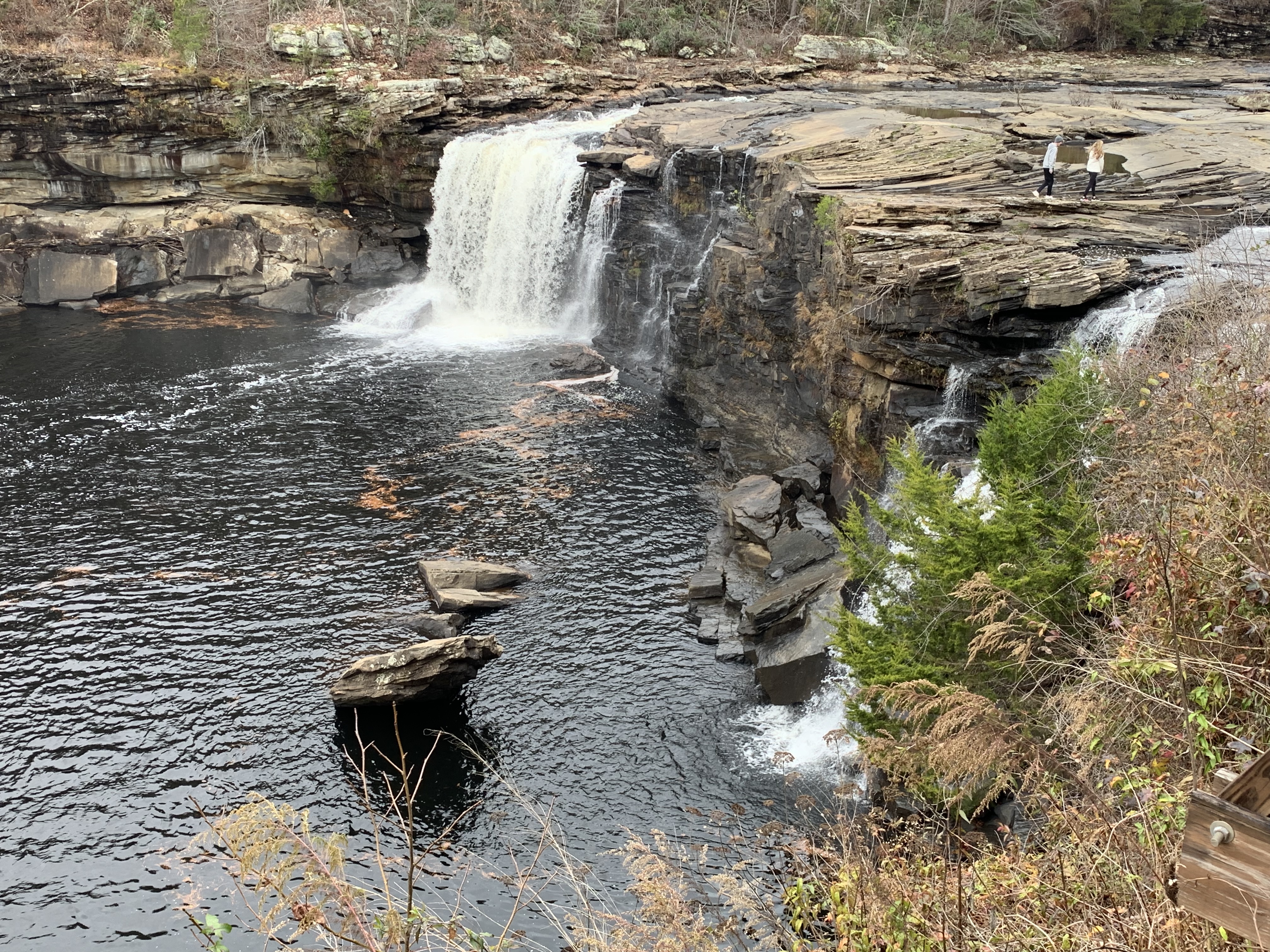
After their long history of interacting with the Spanish, French and British in the southeast, five tribes had become accustomed to European ways enough to be called “civilized”: the Choctaw, Chickasaw, Creek, Seminole and Cherokee. But the US government forcibly removed them to Oklahoma anyway. Most crossed the Mississippi near Memphis, as I did. The Cherokee were split into three groups: the old settlers who moved west before the removal, those forced to walk the Trail of Tears, and those who escaped removal and still live east of Great Smoky. Here, at a natural crossing point through the canyon palisades, the couple in the photo above walk on the Trail of Tears, near where Cherokee families were rounded up into a wooden palisade known as Fort Payne.
The park helps preserve that history, although the primary mission is to protect the many species that live in this important nature sanctuary. The canyon is known among rock climbers for the challenging cliffs, and if you hike downstream there’s a swimming hole near Martha’s Falls. The river isn’t runnable by amateurs, so stick to the scenic drive along the rim, admire the views from a half dozen overlooks and try not to miss the peak foliage like I did. The road isn’t wide enough for both bikes and cars, and, as usual, the former lose out. There’s a park film at the friendly visitor center and an Ol’ Tymer’s BBQ nearby.
Time for me to get back on the road. I passed through Muscle Shoals on my way here, but now I have Georgia on my mind. Places like this are bittersweet, when you reflect on the past or consider the future, but that’s what enriches travel. And our choices make a difference too. Supporting Native American businesses, for example, seems the least we should do to recognize past wrongs. And unless we stop our carbon pollution, these small sanctuaries will prove insufficient to preserve diverse species for any who may follow us.
When I visited this park with my kids, we went to the east unit. Both units are in the greater Tucson area, but both are a decent drive away from the center of town in different directions. So, I was glad to have a chance to see the other side. Although the visitor center is a bit nicer in the west, the east unit has a scenic cactus forest drive where you can easily get out and take a closer look. Both have plenty of saguaro (suh-Wah-ro) to see.