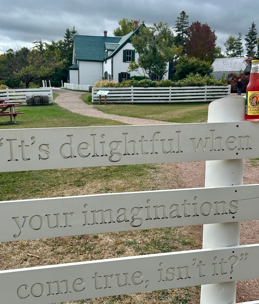
LM Montgomery walked through the woods here trying out dialogue for Anne, her adoptive parents Matthew & Marilla, and her friends Diana & Gilbert. Nature was her kindred spirit, and this home on Prince Edward Island inspired her greatly in writing Anne of Green Gables. The author’s own modest home is almost 10 miles away still in a simple rural village, while the heritage area above is now in the middle of an entertainment district with kiddie rides, candy shops and themed merchandise. At the time Montgomery wrote the book in 1905, it took courage, imagination, determination and hard work to figure out how to inspire people with her delightful story of a girl who embodies those characteristics in a practical, conservative and mundane setting. Five times her manuscript was rejected, before being accepted 3 years later.
While this site is not a world heritage site (yet), I wanted to visit. Anne is a romantic, who fills herself with ideals from literature, and she has to make a place for herself in a stern, reserved household. The themes of youthful dreams, belonging, love, making something of oneself and of wisdom are timeless and precious. When I lived in Japan, I saw Anne interpreted and adapted into a different culture, yet still simply relatable on the other side of the world. There’s great power in imagination, including creating characters that take on a life of their own and also in re-imagining ourselves to live better. Driving past the old farms and churches made me appreciate Montgomery’s imagination all the more, although I suspect she would be less impressed by the summer crowds of kids eating ice cream and riding around in circles. There’s not much imagination involved in doing the same as everyone else.
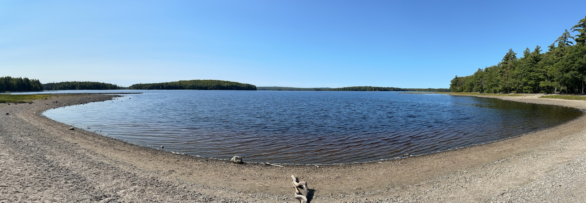
Much of southern Nova Scotia belongs to this UNESCO Biosphere, and the at the center is Kejimkujik Lake, historic site and national park above. My cousin was instrumental in gaining early recognition for the area’s exceptional starlight and dark skies, making it a great place to stargaze. The visitor center has a couple beautiful birchbark canoes and exhibits on the First Nation people who have lived in the area since time immemorial.
Due to extreme fire conditions, the backcountry was closed during my visit, but a few lakeside trails were open. The lake was low, the air and forest dry, but the day was lovely and quiet. The climate change is even more visible to the north, and there were many fires burning in Newfoundland in September. The national park includes a seaside section on the southeast coast with nesting piping plovers on a (closed) beach from April to September, but the biosphere covers far more land, outside the core park, from Yarmouth to both southwest and southeast Nova Scotia.
This UNESCO Biosphere Reserve is in New Brunswick Canada, although the Bay of Fundy is also formed by Nova Scotia to the east. The photo is from the north end at Fort Beauséjour looking south towards where the water comes rushing in with the highest tides in the world. The shape of the bay both funnels the water and creates oscillation that magnifies the tidal surge. The tide is fairly low at this time but already covering some of the vast mudflats that attract thousands of shorebirds, especially sandpipers in mid summer that bulk up on mud shrimp to fly to South America.
Due to the silty water, tidal power has not been harnessed here yet. The Acadians built aboiteaux or sluice gates and dykes here to reclaim some of the nutrient-rich salt marsh land for the fields below. The star fort was taken by the British during one of their conflicts with the French, played a role in the expulsion of the Acadians, and was successfully defended against the Patriots during the American Revolution. But I visited the Bay of Fundy mainly to see the tides, and one of the few places in the world that you can actually see the tide rising is where the rivers empty into the bay. I watched the tidal bore come in near Maitland Nova Scotia, creating waves as the tide forced its way up river.
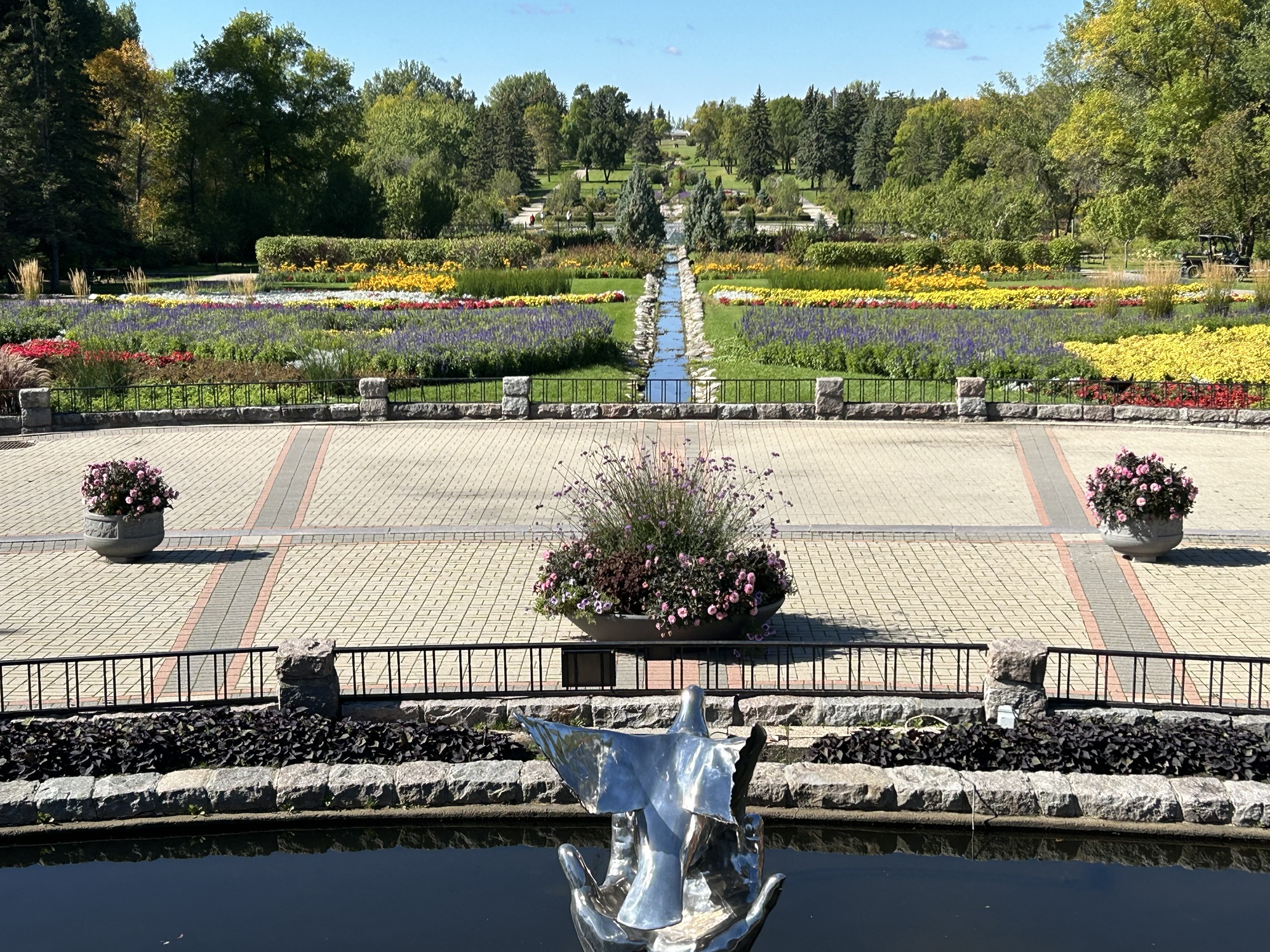
What a beautiful place! A Canadian horticulturalist, Dr Henry Moore, deserves credit for the idea creating a peace garden—built during the Great Depression—on the Manitoba / North Dakota border. America has far more war memorials than parks devoted to peace. Chamizal on the Mexican border is dedicated to diplomacy, and Perry’s is both a war and peace memorial. As we begin a new year, we should not take peace and diplomacy for granted, given all we sacrificed in wars.
This affiliated park, a favorite of mine, is a neutral zone with the entrance between each country’s border security. You will need proper id either to continue on or to return to your home country after your visit here. The park is not far from the small town of Rugby North Dakota, which is the geographic center of North America. It’s a bit of a trek from the nearest US supercharger in Grand Forks, but there are a couple car dealers on the way that offer CCS charging if you have the adapter. Also, the park itself has a free electric 1772 car charger at the drop off entrance to the Conservatory, which has a massive collection of succulents donated by local enthusiasts.
Technically I missed the peak season, but as you can see above, there were plenty of flowers still in bloom at the end of September. There’s a long winding drive through the woods with lakeside picnic grounds below, a campground and a few cabins and more around the central border gardens. And if you walk the length of the formal garden above, the building at the end is the Peace Chapel, which is the perfect place to find inspiration and hope for peace in the quotes from famous leaders and philosophers carved inside its walls.
Pick the best in each of the six regions completed
Visit Canada and Mexico again to see more world heritage sites and biospheres
So I plan to cross the country again this year in my electric car, seeing National Parks from California to Florida, World Heritage Sites from Canada to Mexico, and various lesser known but still important small sites. Logistical challenges or new park designations (thanks Joe) may thwart my plans, but I resolve to do my best.
The posting schedule should continue unchanged all year. Mondays are site visits. Thursdays are typically viewpoints and summaries. And every other Saturday I plan to post a state photo summary. Thanks for following along!
Traditional historians have generally argued that the War of 1812 was about defending US maritime rights, especially of US citizens who were involuntarily ‘impressed’ into the British Navy. Jefferson had certainly left some trade issues with Britain, but such disputes rarely go to war. During the war, the northeastern states continued trading with Britain, and the treaty at the end of the war did not change the maritime rights status quo legally. Americans worked harder at getting compensation for slave owners whose slaves were freed by the British than for US citizens impressed into the British Navy. So that whole explanation for the war is obviously wrong.
More enlightened historians have argued that the War of 1812 was about expanding US territory at a time when the British were busy fighting Napoleon, as stated by the dominant party in Congress and President Madison, who called acquiring Canada “a collateral benefit”. During the war the US invaded Canada 10 times, took land in the southeast including in Alabama, Florida, Georgia, Louisiana and Mississippi, and took land in the then northwest including Indiana, Illinois, Michigan, Ohio and Wisconsin. Most of the US territorial expansion around the time of the war was from Native American lands, regardless of whether they fought for the British or the Americans. So that whole ‘expansion’ explanation checks out.
If we think about the war at all, most Americans view the War of 1812-1815 as about nationalism, patriotism and rallying around our flag, perhaps because we did not achieve any of our objectives, failed to take Canada and had our national capital burned. Canadians tend to view the war more as a heroic defense against our ill-conceived and unpopular aggression, as after all, the Americans burned York—their capital of ‘Upper Canada’ in Ontario province—first. The truth is always more complicated, as you can see comparing the capital burnings. After the British general retreated from York, local militia started fires to prevent the Americans from seizing their supplies, and the resulting gunpowder magazine explosion killed the American general along with ~200 other casualties. The American troops, not under official orders, burned public buildings and businesses. When the British seized Washington DC, they burned most public buildings, including the White House, under orders. Which gives you a sense of the animosity at the time.
Fort McHenry, Fort Washington and the Star Spangled Banner trail focus on the dramatic events around DC and Baltimore, but there are other US park sites that tell more of the story. Along with failing to continue Washington’s peaceful tactics and trade agreements with Britain, the expansionist Jefferson hired Albert Gallatin to reduce the national debt, and Gallatin cut the military budget, leaving successor Madison the contradictory problems of war and a weak military. The US could not match the British Navy in the Atlantic, except for the USS Constitution: Old Ironsides. So the British blockaded the US ships along the eastern seaboard, except for smugglers in New England. So, technically port forts like Monroe and those guarding Mobile Bay had roles in this war, but their primary historical importance is based on events of other times.
The old Northwest Territories around the Great Lakes were long contested by the Americans, British, Native Americans, French and Spanish. River Raisin, near Detroit, is a good place to learn how we provoked the War of 1812 to take native lands. The Americans had two great naval victories during the war, first in 1813 on Lake Erie, where Perry broke the British inland fleet and cut off their supply lines to their western forts, and second in 1814 on Lake Champlain, where Macdonough thwarted a British invasion via the Hudson. The Americans made several incursions into Canada, but were unable to hold territory north of the Great Lakes and even lost their poorly manned Old Fort Niagara in New York, returned by treaty. The war encouraged the French and British in Canada to join together for common defense, eventually forming Canada in 1867. The military stalemate clearly defined the eastern border between Canada and the US, contributing to our long peaceful history since.
In the American southeast, the more consequential war was the simultaneous Creek War and related actions. At Horseshoe Bend Andrew Jackson used Cherokee and Creek allies to defeat other Creeks, even as his allies took lands from both sides. When Napoleon abdicated, the British no longer needed to kidnap American sailors to fill their fleet, and they were able to turn their full attention to their former colony. The American diplomats, led by John Q. Adams along with Gallatin and others, wisely negotiated a peace treaty. But before the news arrived stateside, Andrew Jackson took New Orleans, with the help of the French pirate Jean Lafitte in a story told here. Jackson leveraged his victory to win the White House and used office to enforce the Trail of Tears. He also invaded Florida in 1818, convincing the Spanish to sell the territory to us in 1819. While the Native Americans lost the most in the lead up, during the war and in its aftermath, many African Americans took the opportunity to escape to Canada along the Underground Railroad.
Often overshadowed by the Revolution and the Civil War, the War of 1812 offers many lessons of popular patriotism driving greedy expansionism, reckless militarism and brutally unfair racist policies, with costly, unforeseen consequences. Rather than simply look at flags or teach our kids one heroic story, we should think critically about history so we can make better decisions in the future.
About 15 scenic miles north of Niagara Falls on the US side of the Niagara River is Old Fort Niagara overlooking Lake Ontario. The fort is run by a non-profit licensed by New York State, and it preserves the 17th century stone building, ramparts, drawbridge, cannon and the various accoutrements of French, British and American soldiers who served there from before the Revolution till after the War of 1812. The British took the French fort in a siege in 1759, and then they took it again from the Americans in 1813, bayoneting around 6 dozen. Otherwise the fort changed hands by treaties. The visitor center, fort and grounds make a pleasant, educational diversion from the falls if you’re in the area.
But if you’re interested in forts and war history, I recommend crossing the Niagara River border and visiting Old Fort Erie in Canada. That British fort predates the US and was the site of the bloodiest battle of the War of 1812. Hotly contested for control of the area during that war, the Americans took the fort in 1813, relinquished it, took it again in 1814 and held it against a ferocious siege where each side had over 1000 casualties. While not part of the US Niagara Falls NHA, it is a highlight of Niagara Parks right over the bridge in Canada.
This year I completed loops around all the Great Lakes, crossing the Canadian border in Minnesota, upper & lower Michigan, and western & northern New York, visiting biospheres in both countries. In Canada, UNESCO Biospheres are tourist destinations, where you can hike and see and learn about wildlife, in addition to and separately from their wonderful national and provincial parks. In the US, while some national parks are also internationally recognized biospheres, the United Nations Educational, Scientific and Cultural Organization, UNESCO, is hardly mentioned.
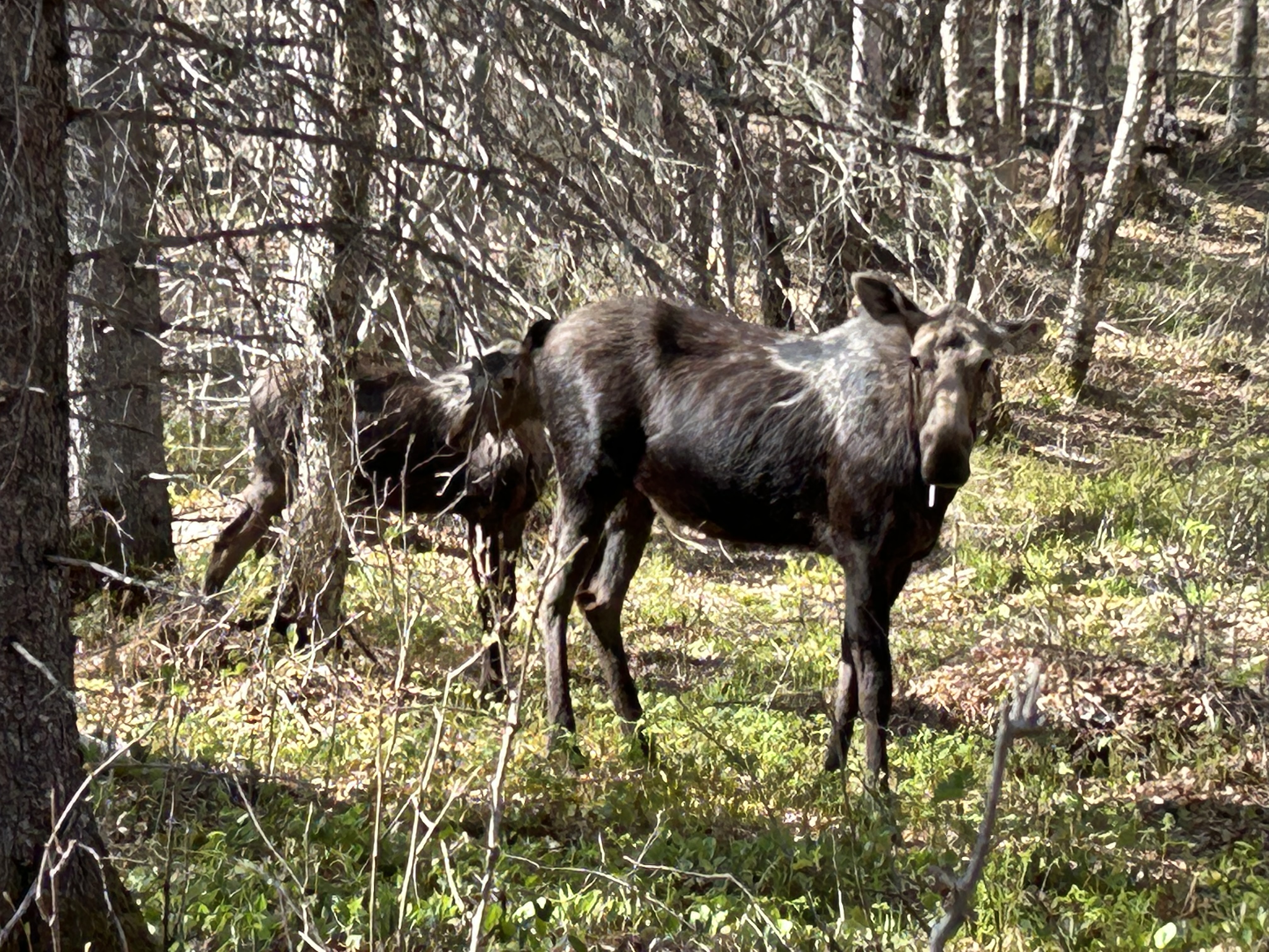
Obtawaing Biosphere is a university project, not well known despite its international scientific research cooperation. Isle Royale National Park attracts many midwestern volunteers for its prey-predator study (see tagged moose above), but even if you ask a ranger, you’re unlikely to learn much about the site being a UNESCO Biosphere. And it took some research for me to learn that Sleeping Bear Dunes is also part of the larger global biosphere network.
Many Americans view our parks as recreation areas for workers to take vacations and spend money as tourists. That nature thrives there is taken for granted. What’s important for most is that you can exercise by climbing a dune, hiking across an island, renting a kayak or biking on a trail. If science is considered at all, it should be presented to the kids in an entertaining, limited format, where kids can learn about ‘weird’ or ‘cool’ animals.
Canada has all of that too, but they also cooperate in international scientific efforts to protect nature. Adults are encouraged to increase their scientific understanding of species too. Their Great Lake biospheres have online visiting information, campgrounds, cooperative agreements with First Nations, birding resources, museums, and both areas that are closed to the public and where the public is welcome. UNESCO is on the signs and in the exhibits.
Sadly, a few Americans believe stupid conspiracies about UNESCO, and some leaders disparaged the science group over an unrelated Israel/ Palestine dispute. As President, Trump removed 17 US Biospheres from the UN program, including Konza Prairie in Kansas. Kansas may not be demographically diverse, but its Tallgrass Prairie is ecologically important to species diversity on earth. The research at Konza used to receive international funding and cooperate with UN scientific efforts, including climate and wildfire research.
There is no logic behind stopping us from receiving funding from the UN for many of our critically important research biospheres, when we need international cooperation to fix the climate crisis. Humans impact nature, and if we’re not careful, we will irrevocably destroy much of our natural environment. Americans should learn about and celebrate our UNESCO biospheres. Please support scientific research and the environment.
I have dreamed of Voyageurs since childhood. Imagine, a park dedicated to canoeists, fur trappers, traders and explorers, with remote boat-in campsites along the Canadian border in Minnesota! The Kabetogama Peninsula is almost an island with only a short portage around some rapids connecting it to the mainland. To the north lies the large Rainy Lake. Kabetogama, Namakan, Sand Point & Crane Lakes lie to the south, with three visitor centers open in summer.
Time limited, I focused on Ash River and took a tour boat out to Kettle Falls, where the southern lakes flow north on their way to the Arctic Ocean. There’s an old hotel there with a wide porch & lawn for enjoying sandwiches & summer sun. There’s another busier portage here, along with a dam and one of the few places in the states where you look south to see Canada. The highlight of the tour for me was going through the islands and stopping briefly at an old resort (see photo).
The park is on the old trading route from Montreal to Great Slave Lake all along the southern edge of the Canadian Shield. Glaciers pushed most layers of soil and rocks south, revealing some of the oldest bedrock in the US at 2.8 billion years ago. The Ojibwe are the traditional gatekeepers of the lands northwest of the Great Lakes. After the Voyageurs, or French fur traders, came miners, lumberjacks, and eventually a few hearty resort owners tried living here. Huge blocks of ice were cut and dragged out of the lake and stored through summer. Logging was massive and filled the coves with timber to be loaded on rail.
Now the forests have begun regrowing, and some wildlife, like elk, have mostly moved north due to climate change. I saw maybe a dozen bald eagles total, including juveniles flying high. The few remaining moose are rarely seen, preferring the swampiest areas far from trails.
I hiked a scenic trail out to Kabetogama Lake Overlook from the Ash River Visitor Center, and there are a couple of other boat tours, one which goes to a rocky garden. I stayed in Chisholm to be near a CCS charger (Combo Adapter needed) and a delicious ‘supper club’ called Valentini’s (order the Walleye). The biggest improvement opportunity would be to have more electric vehicles. There are a lot of noisy gas-powered fishing boats, some being towed by large houseboats. Sound carries far across the lakes, so they definitely detract from the natural setting (and pollute with carbon). Houseboats, slow-moving, sitting in the sun for long periods with large flat roofs, would convert well to solar-electric.
The island itself is off limits, but there’s a viewpoint, a visitor center, some statues, and a rocky cove. The lighter land in the background is Canada. As is often the case in New England, I visited here as a child, although I had forgotten. Rediscovery is rejuvenating.
The French were determined to establish a trading post here in 1604, but the winter killed half of them. One of the survivors was Samuel Champlain, who went on to found Port Royal in Nova Scotia—the first successful colony north of Florida—and Quebec. He also accurately mapped the coastline, opened fur trade with the natives and was de facto Governor of New France.