All UNESCO Sites in Ontario

Ontario is Canada’s most populous and prosperous province, with over 1/3 of the population. Both the country’s capital, Ottawa, and its largest city, Toronto, are here. 1/2 the residents of Toronto were born abroad, making it one of the most multicultural cities in the world. Ontario borders Great Lakes Erie, Huron, Ontario, and Superior, plus Hudson Bay to the North.

Ontario has a World Heritage Site that is fascinating to explore. The Rideau Canal is the oldest continuously operating canal system in North America, and its quaint villages along the route connecting Lake Ontario to Ottawa are delightful, with treat shops, friendly restaurants and charming historic hotels.

Four UNESCO Biospheres protect the unique ecosystems defined by the Great Lakes ice age landscape.

  • Frontenac Arch is the geologic bridge to the Adirondacks that holds back Lake Ontario, best seen where the St Lawrence River cuts through the Thousand Islands area. Bitterns, Eagles, Heron, Loons and Osprey live here.
  • Georgian Bay, off Lake Huron, is almost as big as Lake Ontario, and it protects many rare birds, reptiles, butterflies and other species amidst First Nations land.
  • Long Point is on the north shore of Lake Erie, and it has birding, boating, hiking and more to enjoy.
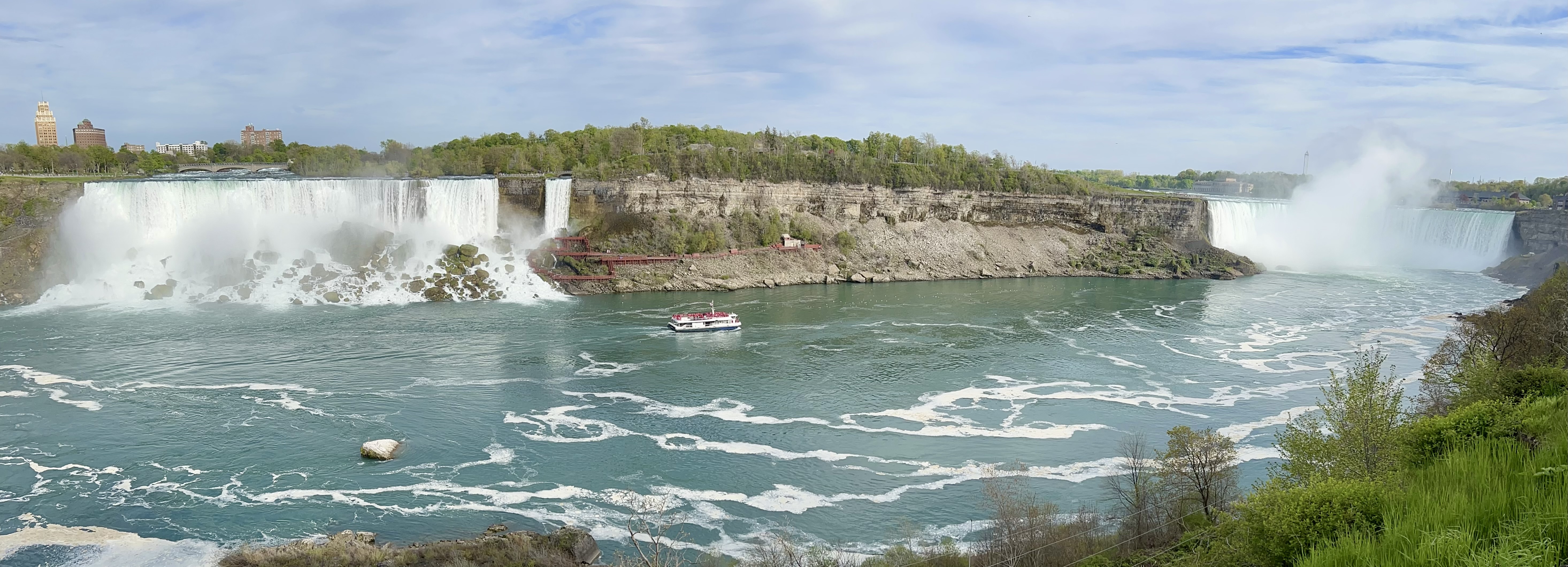
  • Niagara Escarpment is a massive geologic formation that forms the northeast shore of Lake Huron, stretching from Buffalo NY on Lake Erie to Green Bay WI on Lake Michigan. Its forests and coastlines contain more species than any other Biosphere in Canada.

Best of the North Atlantic

Best Park: Acadia. Wildlife, wilderness, views, varied hiking, boating, camping, forests, mountains, waters. Acadia National Park, above, is the only National Park in the region, the best North Atlantic park in many categories, plus proximity to fresh lobster rolls.

Best State: Massachusetts. Oh, sure, New York has more sites overall, more presidential sites, more historic sites, more Civil Rights sites, more recreation areas, plus 2 world heritage sites, but Massachusetts is still better. Just like the Red Sox are better than the Yankees.

The North Atlantic specializes in history, exemplified by these best-in-class parks.

Best Affiliate: Touro Synagogue.

Best Art: Saint Gaudens.

Best Bicycling: Cape Cod.

Best Forest: Marsh-Billings-Rockefeller.

Best Heritage Area: Upper Housatonic.

Best Ranger: Women’s Rights.

Best Trail: Climb Mount Katahdin on the Appalachian Trail.

Best World Heritage Site: Statue of Liberty.

Hidden Gem: New Bedford Whaling.

Read more about all parks in the North Atlantic region.

Best of the Mid-Atlantic

Best Park: Harpers Ferry. In a region known for great historic sites, Harpers Ferry is exceptional. At the confluence of the Potomac & Shenandoah Rivers, where the C&O Canal, Potomac Heritage and Appalachian NSTs all merge, scouted by Jefferson and taken by Grant, martyred by John Brown and lifted up by WEB Du Bois, this park is essential for Civil War and Civil Rights history.

Best National Park: New River Gorge, with whitewater rafting, scenery, wildlife, hiking and coal mining historic heritage, this gorgeous new national park is more vibrant and exciting than its beautiful 100 year old competitor, Shenandoah.

Best State: Virginia has many Civil War sites, presidential birthplaces, and many other important historic sites, including world heritage Monticello, plus scenic mountains, rivers, valleys and coast.

Best City: Philadelphia is chockablock full of history and museums, mostly in world heritage Independence NHP.

The Mid-Atlantic specializes in history, exemplified by these best-in-class parks.

Best Affiliate: Patrick Henry’s Red Hill

Best Anthem/ Flag: McHenry

Best Culture: Wolf Trap

Best Drive: Shenandoah

Best Heritage Area: Journey through Hallowed Ground from Monticello to Gettysburg

Best Wildlife: Assateague Island

Best World Heritage Site: Fallingwater

Favorite Hero: Clara Barton

Hidden Gem: Maggie L. Walker

Smallest Park: Koscuiszko, the smallest park in the country

Worst Civilian Tragedy: Johnstown

Read more about all parks in the Mid-Atlantic region.

National Capital Trails

There are 3 National Historic Trails in the beautiful District of Columbia below. Enjoy!

There are also 3 park units in the region that are different types of trails: sections of the Chesapeake & Ohio Canal NHP, George Washington Memorial Parkway, and the Potomac Heritage NST.

Trails are a great way to explore multiple parks in a region, especially when linked thematically.

Rideau Canal

A series of locks allow small boats through Jones Falls below on the lovely historic river and canal connecting Ottawa to Kingston in Canada. In season from mid-May to mid-October, the boats tie up on the dock to the right and wait their turn, perhaps staying or getting something to eat at the 1870s lakeside Hotel Kenney. Chaffey’s Lock is another of the many pretty, historic locks, and it has a fancy hotel, a lock-master’s fort—in case the Americans try to invade by canal—, and a swing bridge that rotates on a wheel to let tall boats clear the lock.

The canal is recognized by UNESCO as a World Heritage Site. There are a couple dozen locks between Ottawa and Kingston Ontario built almost 200 years ago to facilitate trade and travel between the Great Lakes and the Atlantic Ocean. Today, giant cargo ships stick to the main St Lawrence Seaway, but that shift left a dozen or more adorable “timeless” little villages along the original canal route. Small boats still use this canal to avoid heavy barge traffic, dangerous currents and because it’s beautiful and fun. Much of the canal is short sections that connect a series of lakes, including Lake Rideau. If you visit the town of Westport, I recommend dinner at the atmospheric old Cove Inn, which often has live music.

Gateway National Recreation Area

Gateway is multifaceted, but for me the most important part is the Jamaica Bay Wildlife Refuge above. Here there are migratory and year round birds, butterflies, trails, groves of trees and pleasant views. The contrast between the busy planes of JFK and the mute swans could not be more striking. Although the road noise limited my birdsong app, I still lost count at a dozen species. With more time, I would have kayaked around to see more birds.

But for folks interested in other things, the park includes Forts Hancock, Tilden & Wadsworth, beaches, parks and more, spread out over western Long Island, Staten Island and Sandy Hook peninsula in New Jersey. The Sandy Hook unit has miles of beautiful beaches (below with NYC skyline view) and paved bike trails to enjoy.

Cape Cod National Seashore

The park extends from the fist to the elbow, from around proud Provincetown to historic Chatham Harbor, and there’s much to see and do. For me, the quintessential experience is to find an isolated stretch of beach and walk until the birds far outnumber the people. I saw dozens of grey seals swimming right near the shore or lying on the rocks just off the beach. It’s difficult to get to any beach without passing a lighthouse, but if you want to climb one, your best shot is Highland Light (above), the first one commissioned on the Cape by one George Washington.

There are about a dozen named trails too, and I’d recommend hiking near Fort Hill, where you can see the Penniman House, get a great view of the marsh, and spot many different birds. With the aid of a birdsong identifier, I counted 18 different species in one day, including the rare Indigo Bunting and an uncommon Willow Flycatcher.

If you have a bike, consider taking the Cape Cod Rail Trail, which is a high-quality dedicated bike trail through about 1/3 of the cape, and there are also other decent bike lanes and bike trails. My first bike trip here a few decades ago, extended the length of Cape Cod, plus the islands of Martha’s Vineyard and Nantucket, returning by ferry from Provincetown to Boston. When I last visited the lighthouse above, it stood where I stood to take the photo above, because the highland cliffs are eroding at several feet per year, forcing them to move the lighthouse in the intervening decades.

Visiting in shoulder season, rather than July-August, helps avoid miserable traffic and exorbitant hotel rates. There are also lots of good seafood shacks, still one or two cheaper motels, some campgrounds, and lots of nature. Wellfleet is well known for oysters, and the fried clams here are the best I’ve had. I’m still on a quest to find the best lobster roll, and I suspect it will be lifelong. Though speaking of seafood, I would be careful swimming around here, as great white sharks prowl along the shores.

Delaware Water Gap National Recreation Area

To say the gap is in the Poconos is redundant, because ‘pocono’ means water gap in the Lenape language. The whole area was supposed to be inundated by a flood control project, but that was deemed too expensive. Which is great, because the park service preserves big, beautiful, wooded, hilly land on both the New Jersey and Pennsylvania sides. There are at least seven named waterfalls with trails—above is one of two easily seen on Dingmans Creek Trail—, more hikes including a section of the Appalachian Trail, an exceptional bike trail, many campgrounds, some historic buildings and more. A brown bear crossed the road in front of me, so there’s definitely wildlife here too.

Technically, the 35 of 40 miles of river itself is a separate park, and the gap is the land plus 5 miles of recreational river. If it were up to me, I would combine this with the Upper, Middle and Lower Delaware River parks, and make all four into one National Park. That’s been proposed, but some residents oppose it. Traffic or something. I found it easy to drive around, but crossing the river gets you a toll. If we want to preserve species, we need to start being much more aggressive about preserving our rivers and forests.

Cuyahoga Valley National Park

Cleveland’s mayor, the first African American elected mayor of a major city, Carl Stokes, faced an environmental crisis. The Cuyahoga River, above, caught fire in 1969. And it wasn’t the first time. Mayor Stokes led journalists on a pollution tour and tied the issue to poor and underserved communities, many of color, which often suffered most. He led the fight for change.

In many ways, this park is a great example of what can be done, when we make the effort to restore nature. While interstate highways still cross over the park, they do so from extremely high bridges, separate from the deep valley below. Many tributary watersheds are protected by municipal and state parks and other reserves. Instead of removing the old railroad line along the river, there’s a classic old train line with restored historic whistle stops for hikers, bikers, and even kayakers to return after traveling through the park one way. An old inn on the canal has been repurposed as a museum. An old mill village is now a visitor center with a store selling drinks, sandwiches and ice cream (black raspberry chocolate chip is the best). The tow path, which both separated the canal from the river and provided a walkway for teams of oxen to pull barges, makes a perfect, nearly level, dry, packed gravel path for bikers, hikers and equestrians to travel for miles through the woods, admiring both wildlife and the beautiful scenery.

This is my favorite park for bicycling. I biked from Frazee House to Peninsula, above, about 20 miles round trip, in order to see some of the northern and middle sections where the path runs close to the river and far from the road. I saw both a Bald and a Golden Eagle, the first with the help of a park volunteer who let me look through his telescope. Brandywine Falls also surprised me by being larger than expected in Ohio, and the Ledges is another popular hike. I also hiked through Beaver Marsh at the southern end to look for more birds and watched a Great Blue Heron fishing for about an hour, among the geese, various ducks, redwing blackbirds, giant snapping turtles and other wildlife. Wonderful!

Point Reyes National Seashore

The staircase down to the lighthouse below is often closed due to high winds, and, especially during the summer, the scene above is hidden in fog. Of course, that’s why the lighthouse was needed, as this rocky point sticks far out into the Pacific, due in part to the San Andreas Fault. If you hike the Earthquake Trail from the Bear Valley visitor center, you can see a fence that has a 16 foot gap representing how far the land moved along the fault line in 1906. There’s also a replica native village and a horse ranch that used to raise Morgans.

Due to its remote coastal location, there are wildlife viewing opportunities, especially Tule Elk at the north point, migrating whales, seals, and birds in different seasons. I saw a coyote, some raptors, deer and coveys of California Quail (our state bird), and I only visited the lighthouse this trip. There are glorious miles of hiking trails, especially out to the estuary and Drakes Bay, where Sir Francis Drake most likely landed during his 1579 circumnavigation.

The park service is working to preserve and restore the area due to its ecological importance. The commercial oyster farm out here is gone, but there are still several historic ranches that date back to the 1850’s. There are kayaks for rent next to the Tomales Bay Resort in Inverness, and the town of Point Reyes Station has some restaurants and organic markets for picnic supplies.