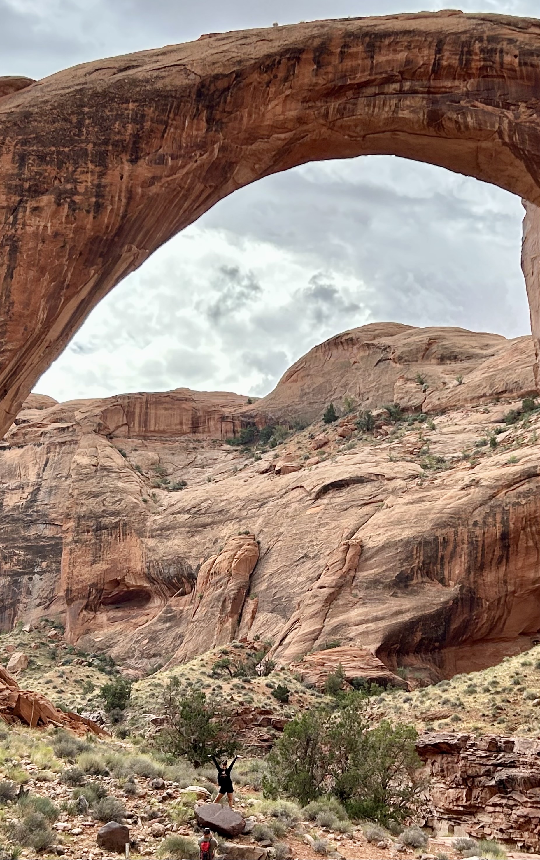
Luckily Lake Powell is high enough for the boat tour, which cost $145 and took 7 hours, including an hour hike, 30 minutes at the bridge above (see people bottom right for scale) and a beautiful song sung at the site by our Navajo guide. That’s far better than hiking overland for at least two days. At least Zane Grey (below left) had the sense to ride a horse. This is my favorite park to follow in his footsteps. The boat trip alone is marvelous, as Glen Canyon just gets more stunning the deeper you explore into Utah. But the canyon up to the monument is a delight too, with wildflowers, echoing cliffs & alcoves and a spring, allowing you a glimpse of a glen before the dam tragically flooded most of them. Before our Navajo captain navigated the twisting channel for the return trip, a brief shower brought at least half a dozen waterfalls down the towering rock walls. Spectacular!
This forest service trail runs between the borders of Mexico and Utah. The southern Sky Islands section includes Coronado National Monument and Saguaro National Park near Tucson, and the terrain ranges from low desert to 10,000’ mountains. The next Sonoran Uplands section crosses seasonal desert rivers and passes by the Tonto National Monument (see photo). The Volcanic Field & Ponderosa Pine Plateau includes Walnut Canyon near Flagstaff. And the northern Plateaus & Canyons section crosses through the southern part of the new Grand Canyon National Monument and both south and north rims of the Grand Canyon before reaching Utah.
While I’ve visited the park units along the way, hiking long sections of the trail is too challenging for me, with risks from heat stroke to flash floods. But it would be an adventure! Driving to the parks along the trails is an easy way to see a few of the highlights, and I will be posting about several more trails this fall.
Below Glen Canyon‘s Horseshoe Bend, there’s a low point at Lee’s Ferry where rafters put in to run the rapids down into the Grand Canyon. First they go under Navajo Bridge and through Marble Canyon. The Colorado River and cliffs here are still part of Glen Canyon, but there’s a large, ecologically important shelf or rim under the Vermilion Cliffs (distant above right) that was weakly protected. A few clever folks figured you could camp out right on the rim above and watch the rafts and stars go by.
I found this place above on the map, but it’s not well known. It’s called Rapids or Beaver Creek Overlook, and there’s a 2 mile dirt road from 89A not far from Cliff Dwellers & their destination charger and tasty restaurant. I asked a local Navajo woman about the road, and she described it as ‘nice and flat’. Which is true, because the views are lovely and the wide rim is basically flat. But it would have been easier in a high clearance vehicle. I guess she has a different standard for ‘nice and flat’. Still, my car is visible on the rim above to the right, so I can’t complain. If you go, please stay on the road or in one of the very primitive camping areas as the small cacti and desert soils are fragile.
Navajo and other tribes petitioned for better federal protection of such lands all around the Grand Canyon to prevent uranium mining and other damage. President Biden agreed. The park name means ‘where tribes roam’ and ‘our ancestral footprints’ in Havasupai & Hopi respectively. Even larger areas are now better protected in the west and south, including a large chunk of the Kaibab National Forest below the south rim. The new park is managed by the US Forest Service, so like Avi Kwa Ame it won’t count as one of the 425 official NPS units. Still, it’s new, important and on my way.
Back in March, President Biden declared Avi Kwa Ame—Spirit Mountain—a new park, so I took another look on my way back to the Rocky Mountain region. (The park is managed by the Bureau of Land Management, so technically it’s not one of the 425 official park units). The park is in the Cal-Nev-Ari bottom corner of Nevada, filling the gap between the southern end of Lake Mead NRA and the Mojave Preserve. Last year I rode my bike through the western part of it on my way to Castle Mountains, past Joshua Trees and Clara Bow’s ranch.
On Sunday, I hiked up the Spirit Mountain Overlook trail to take the photo (above) of the sacred mountain from a respectful distance. The mountain is actually just over the Lake Mead NRA border, but both the foreground and background to the left are in the new park, until Mojave in the distance. I relied on HikingGuy.com for directions, which were helpful, plus the NPS App: save the Lake Mead park info for offline use, then open the map to see your GPS position. There are natural springs up here, so there were birds along the trail. Connecting the parks helps protect the threatened desert tortoise. I saw one crossing Christmas Tree Pass Road when I drove up and again on my way back down (not sure if it was the same one;).
The 220’ three-tiered Whiskeytown Falls were a local secret known only to loggers and a few others until rediscovered by the park service staff in 2004. The ‘strenuous’ trail opened in 2006, and, since the shaded trail is in the 3% of the park not completely burned by the 230,000 acre Carr Fire in 2018, I decided to hike it earlier this summer, rather than broil on the water in my kayak.
But then these folks from Cal-Fire Bully Choop & Sugar Pine CC #9 passed me on my way up. Rather than complain, I gave them a bit of applause and thanked them for their heroism. They were taking turns cooling off in the 50° water. Of course, it’s not fair to expect these young people to risk their lives to protect our forests and property from the Climate Crisis we are all guilty of making worse, so they deserve our thanks all the more.
Shasta, Trinity and Whiskeytown Lakes are all National Recreation areas in the Shasta Trinity National Forest, with the first two managed by the US Forest Service and the latter by the National Park Service. Shasta is the largest, and you may have driven over it on I-5 in northern California. Whiskeytown is the smallest, but all three suffer from lower snowpacks and longer droughts due to climate change.
At the Whiskeytown visitor center, I noticed that they are using an underwater curtain to block the warm surface water from continuing downstream from the dam. This innovation helps keep the water temperature low enough for Chinook salmon eggs and fry in the Sacramento River. I’m not sure how long it will work given the Climate Crisis, but it’s the least we can do after damming Clear Creek. Maybe we could ban gas-powered boats too?
I was disappointed to read the park newsletter with three long articles about the fire and zero mention of the Climate Crisis. I expect my tax dollars to be used more wisely. Denying the crisis only gives us less time to act.
Sometimes the story is more important than the scenery, and Ranger Danny told it well. In April 1942, US citizens of Japanese descent on the west coast were given 2 days to pack 2 suitcases and check in to temporary relocation centers, losing their freedom and property in violation of the 4th Amendment. They were not given due process in violation of the 5th Amendment. FDR’s order was popular—especially among those who planned to take their property—, and the wartime Supreme Court partly upheld it, in the infamous Korematsu decision, while simultaneously partly dismantling it, in Endo. Reagan apologized and offered survivors small compensation.
Many Americans grew up either not knowing much about this or believing it justified by war. The Japanese military attacked Pearl Harbor without warning, after invading their neighbors, occupying Shanghai and committing atrocities in Nanjing. When FDR’s order went into effect, Japan had taken Hong Kong and Singapore, and they held several thousand American civilians as prisoners for the duration of the war, with insufficient food, forced labor and a high death rate. Americans did not want to prove themselves better; they wanted revenge.
And yet the Germans had acted similarly, with sneak attacks, invading neighbors and taking prisoners, but the US issued no similar order to imprison US citizens of German descent. Americans lost relatives in battle to both foes. Both aggressive countries employed spies. Japanese Americans do not appear different from other Asian Americans, so Japanese spies could still operate on the west coast. There is no justification for abrogating the rights of Japanese Americans, not expediency, not greed, and certainly not racism.
These ten American Concentration Camps were a failure of leadership, imagination, morality, of our government and of rational behavior. Having dispensed with our Constitution, the rules were arbitrarily made up on the fly. The US military defined a huge ‘exclusion zone’ from Washington state to New Mexico, fearing another naval assault in Arizona?!? Hawaii, despite being the location of Pearl Harbor, detained few Americans of Japanese descent. Japanese Americans who already lived in Idaho, Utah, Wyoming, Colorado or Arkansas witnessed their fellow citizens arriving in their states and being imprisoned for having the same cultural background as they did.
The US military still wanted to draft soldiers from the citizens they detained, so they created a loyalty questionnaire to invite them to fight in Europe. The government then started using the questionnaire to divide the incarcerated into loyal or not. The questions were convoluted, rewritten in some camps and many were misadvised on how to respond. Since Tule Lake only used the original version, they had a higher ‘failure’ rate, so they got a reputation for disloyalty. Inmates exercised their 1st Amendment right to protest, and the military sent in tanks. Then they had the inmates build a concrete jail inside the barbed wire, machine gun manned watchtower prison. One man was interrogated for 12 days because his mother accidentally played a borrowed radio. Many inmates here were pressured into renouncing their US citizenship.
One reason that most Americans don’t know much about this history, or have mistaken views, is that the US government intentionally misled the public about conditions here. The press was invited in to see the one barracks in Tule Lake where everyone was happy and would receive steak for dinner in return for cooperating, while the remainder of the massive camp was suffering from basic food & water shortages. The image of the ‘happy Japanese interns’ was amplified as propaganda, which some visitors still repeat today.
The highly recommended ranger tour is given on summer weekends out in the field (above) and in the jail, complete with jail cell bars saved by a local to preserve the real story. The camp is 10 miles outside town, per military requirement, and there are a few original buildings, the top of a watchtower and a stone monument, besides the small visitor center. The site is in the far northeast corner of California, in the reclaimed lake bed, quite close to Lava Beds. It’s remote, but important to visit.
I recently completed visits to all the caving parks by electric vehicle. To be clear, with caves running under all 50 states and over 100 parks having some type of named cave, this only lists parks where theprimary activity is to visit a cave, almost always on a guided tour.
Subconsciously I become a bit claustrophobic in subterranean spaces, so I compensate by imagining what type of monsters best suit the scene. Rangers who do cave tours are quick to get this humor, although it’s best not to spook other troglocenes—cave visitors—in case anyone is seriously fearful. Below, I describe both the scientific cave category and my own cave creature category.
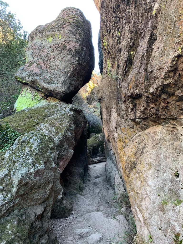
Talus caves are formed when boulders stack up in narrow passages, and Pinnacles in California is the unit to explore these. The large boulders and varying heights made me feel like a dwarf, my first category.
“Caves, they say! Caves! Holes to fly in time of war, to store fodder in! My good Legolas, do you know that the caverns of Helm’s Deep are vast and beautiful? There would be an endless pilgrimage of Dwarves, merely to gaze at them, if such things were known to be. Aye indeed, they would pay pure gold for a brief glance!”
— Gimli
California’s Lava Beds is the best place to explore different types of lava tube caves, and the skulls and ice-cold rooms are ghostly. Craters of the Moon in Idaho has a similar cave, but obviously that’s more werewolf. El Malpais is more for self-guided, serious spelunkers, but many natural entrances can be seen. Definitely bats.
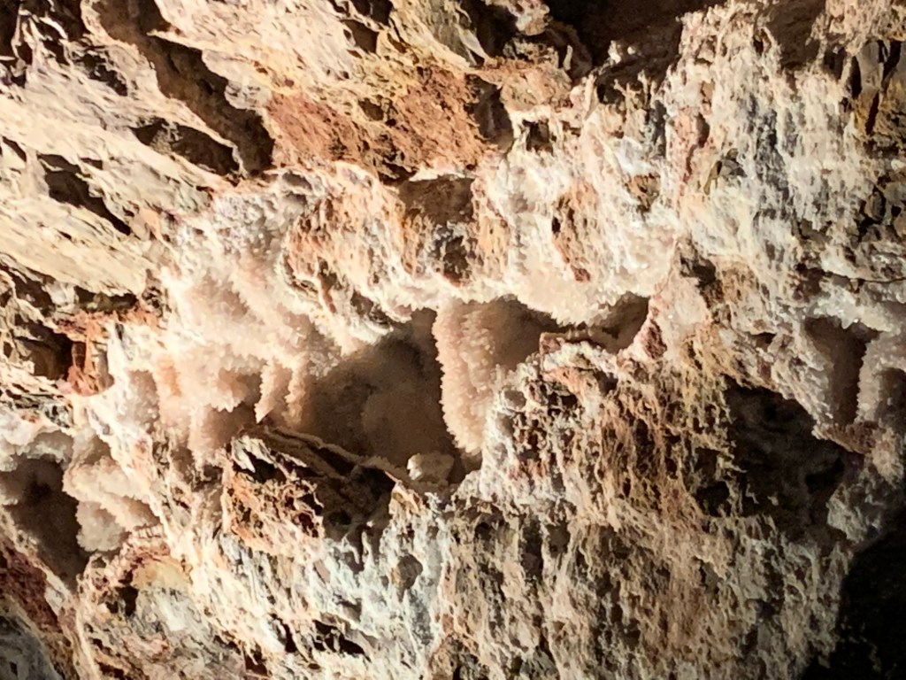
My favorite cave park is Timpanogos in Utah, due to the good condition and variety of speleothems (features created by water). The alien features evoke melon heads. Solution caves, created when liquids dissolve bedrock, are the most common types of cave parks. Carlsbad in New Mexico is the largest with grand speleothems that tower overhead (see photo). Try not to listen for goblin drums coming from the deep. Mammoth in Kentucky is the longest in the world with tunnels fit for lizard people. South Dakota’s Jewel and Wind caves rank 3 & 7 in the world for length, each with different speleothems to see. Also, think Djinn and Minotaur, respectively. Oregon completed my solution cave set, and it’s a good example of a marble cave. Definitely a troll cave.
That’s my complete list of caving parks. Great Basin is not primarily a caving park despite dragonesque Lehman Caves, because the park has such wonderful above-ground scenic views and alpine hiking. Neither is the vampiresque Karst-cave Ozark, since paddling is primary. Nor is archaeological Russell in Alabama. Before going zero carbon, we visited lava tubes in Hawaii, but there’s flowing lava to see. The parks have many more mines, ice, sea or littoral caves, but not primarily for caving.
And always remember to wear completely different clothes and shoes when visiting different caves, so you can help prevent the spread of the lethal white nose syndrome among different populations of bats! I never imagined I’d use all those Chuck Taylors I bought during their bankruptcy underground; perfect in case I need to run from a basilisk.
One of the surprising number of caves here, this photo is just inside the entrance of Valentine, a large multi-tube lava cave that’s fun to explore. I also like Skull Cave (named after animal skulls, mostly). It used to have a pristine ice floor at the bottom, but that’s turned dark, uneven and much smaller due to people. Merrill Cave used to have an ice floor large enough for skating, but it melted recently due to global warming, drained into a hole, and opened up a warm air vent. The same sort of thing has happened to at least a dozen other caves here, so you’re too late for the underground ice experience here, forever.
And it’s definitely a cave park. Except for parking lots, few walk around above ground. In 2000 the 85,000 acre Caldwell Fire burned 2/3 of the park, so I’m not sure what’s left to see besides dead trees and, of course, the lava beds themselves, which are black, rough and inhospitable. I recommend going to the visitor center to borrow a large lantern if you don’t have one, otherwise it can be hard to see down the more distant passages. They also have helmets if you’re a smaller, more flexible person who is willing to try the many more challenging caves. And, if you’re wondering what type of caves they have here (Goblin, Lizard or Vampire), I have to say Ghost. The caves have a haunted atmosphere with many strangely cold corners deep in the earth. Enjoy!
Here are my visits to all parks in California and all caving parks.
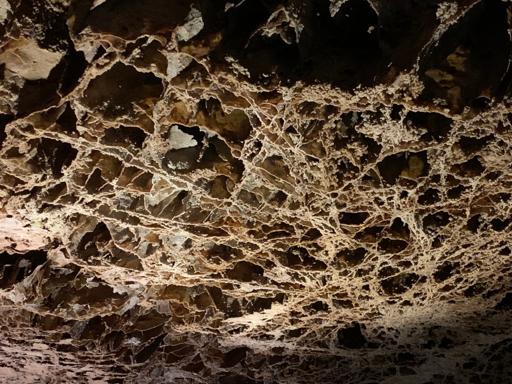
Since the cave was discovered in 1874, explored and expanded early, humans caused very significant damage to geologic structures making it hard to find beautiful natural features. The ‘cave drapery’ above is at the top of two flights of metal steps up to the Paradise Lost high ceiling above the Ghost Room in the far back of the cave tour. The cave has a stream pouring out from the entrance, and there’s a pretty pool there in front of the Château, which is closed pending renovations. Cave Creek turns into the Wild & Scenic River Styx while underground, the shortest section of river so designated nationally. There are also several pretty hikes above ground, including one to a very large Douglas Fir. Easy to get tickets at rec.gov or at the visitor center in Cave Junction, before driving all the way up to the cave itself. Be sure to check in as soon as you arrive at the other visitor center next to the cave, as they often let folks take an earlier tour when space is available, especially in the morning.
Here are my visits to all parks in Oregon and all caving parks.
John Day was merely an unfortunate trader who got robbed along the river here, but the event was noteworthy enough that this Columbia River tributary was named after him, then the whole region in Oregon. I first explored the area in 2017 when finding a campsite to observe a full solar eclipse, but I skipped the fossils. I really should have visited the museum earlier.
The John Day Wild & Scenic River flows through a huge volcanic landscape that contains the best Cenozoic fossils discovered in the country. Layers of forests and ash preserved some of the most important fossils used to understand evolution. The Cenozoic is the age of mammals, including the John Day Tiger above and the big entelodont (pig/hippo) behind it on the left. There is a camel skull, a gomphothere (elephant) jaw, mastodon teeth, horns of a giraffe-deer, bones of a short-faced bear previously thought to live only in Asia, rhinos, and some kind of giant dog-bear called a nimravid. There are also fossils of the Dawn Redwood, which still lives in China. The fossils I’ve seen at Fossil Butte, Florissant and Agate are all from periods covered here. If you have time, it’s possible to hike in the three separate remote park units, but the exhibits above are in the Condon Visitor Center in the Sheep Rock unit near the scenic Picture Gorge.