Sleeping Bear Dunes National Lakeshore

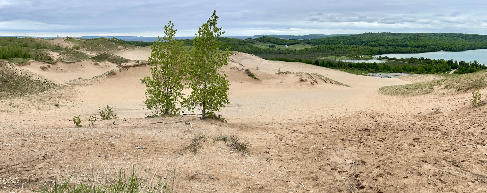
The small lake on the right is Glen Lake, and Lake Michigan is at the top left. If you zoom in to the right, you might see tiny people climbing the middle dune from the parking lot. I got up to this vast view on the pleasant Cottonwood Trail (less than 2 miles round trip) from the Pierce Stocking Scenic Drive, which also takes you to the breathtaking Lake Michigan Overlook and the splendid Sleeping Bear Overlook. Many folks seem to want to do things the hard way, but I definitely recommend hiking from the scenic drive. The impressive Sleeping Bear Dune itself is over 1000 feet high, and folks frequently need rescuing ($3,000) after climbing down to the lake and not being able to climb back up. A few extreme winter folk ski down the steep dune to the lake. Not sure how they get back up. Please stay on the trails, as past humans caused much erosion damage to the fragile ecosystem here. This is a beautiful park with wildlife, deep Native American roots, and it is part of a new UNESCO Biosphere across northern lower Michigan.

Obtawaing Biosphere

The University of Michigan Biological Station—better known as ‘bug camp’—on Douglas Lake (above) began over 100 years ago, and now, under its new Anishinaabemowin name, it is recognized as the heart of a huge UNESCO biosphere protecting species in northern Michigan. While UMBS is not a tourist destination at all, I saw groups of enthusiastic students and researchers preparing scientific experiments and data collection, various boats and a large protected forest. They are doing important research on the Climate Crisis and preparing a new generation of experts with hands on experience. We need to stop climate change denial, pay attention to the science and stop carbon pollution, before it’s too late.

Bronzeville—Black Metropolis National Heritage Area

The South Side of Chicago has long been a historic district, and now it will be recognized as its own National Heritage Area. This is the neighborhood of activist Ida B. Wells, the church for Emmett Till’s funeral, of poet Gwendolyn Brooks, boxer Jack Johnson, musicians Louis Armstrong and Nat King Cole, and where a young community organizer named Barack Obama worked before law school. 1/2 a million African Americans moved to Chicago during the early 20th century. Above is the Monument to the Great Migration at MLK & 25th, welcoming people to join the community, and every so often you will find a bronze plaque recognizing accomplished residents on the walk to 35th, where there’s another statue, honoring the African American soldiers who chased the Germans at the end of WWI.

The neighborhood continues south, with many beautiful brownstone buildings and a few blues venues. Unfortunately, many historic buildings—like the Checkerboard Lounge where Muddy Waters used to play—were lost to poor government planning, an expressway that cut the neighborhood off, and expansion of the University of Chicago. Establishing a specific heritage area helps recognize the unique cultural value of a neighborhood, encouraging more visitors by promoting it. Now, I expect Black Metropolis will continue experiencing its renaissance, and I look forward to trying the food at Bronzeville Soul (closed Mondays) the next time I pass through town.

Affiliated Sites in Midwest

I recently completed EV visits to all five NPS affiliated sites in the Midwest, which were interesting and educational. Wisconsin is a good place to learn about drumlin hills, kettle lakes and moraine at the various park interpretive centers in the Ice Age National Scientific Reserve. The story of Father Marquette’s voyages and the Chicago Portage stretches through several states. Toledo Ohio keeps history at the Fallen Timbers Battlefield and Fort Miamis (see the fort’s footprint above) on the banks of the Maumee River. And Nebraska protects Chimney Rock on the pioneer trails.

Much more coming soon, including three national parks, biospheres, and heritage areas as I wrap up the Midwest region. And I reveal my secret project. Stay tuned!

Grand Portage National Monument

[Update: Blackwell National Historic Site in Texas is now officially a national park unit.]

The photo is from the moose exhibit upstairs at the visitor center. I failed to photograph a bald eagle flying right in front of the reconstructed fort, which includes a great hall, kitchen, warehouse, lookout and wooden palisade. The monument is surrounded by Anishinaabe (Ojibwe/Chippewa) land, and the tribe co-manages the unit, a first for the NPS. I stayed at the casino to catch an early ferry from Grand Portage, and I had a delicious ‘lunker’ (big fish) for dinner. From the dock, you can see Isle Royale in the distance, and there are various demonstrations of the fur trading life during the summer season.

Traders wanted access to the western rivers and lakes, and the easiest way to get there was to carry their canoes on the ~10 mile Grand Portage Trail around some impassable waterfalls (including Minnesota’s largest) on the Pigeon River at the border with Canada. At a site called Fort Charlotte, the voyageurs entered the Pigeon River—now the US-Canada border—and continued with shorter portages upstream on the Athabasca, English & Saskatchewan Rivers. They would pass through what’s now Voyageurs National Park, Rainy Lake, Lake of the Woods, and deep up into the Canadian Rockies to the Athabasca, Great Slave, and Winnipeg Lakes. The trail carried beaver and other pelts, typically trapped by natives, in 90 pound packs from inland Canada down to Montreal (skipping the polar bears around Hudson Bay), bound for global markets in Europe, Russia and China. Vast fortunes were made wiping out the abundance of our wildlife.

Arkansas in Photos

Celebrating visiting all park sites in Arkansas by EV and updating the Natural State on my map! Arkansas has both beautiful natural and many important historic sites. Below see Arkansas Post, Buffalo River, Bill Clinton Birthplace, Fort Smith, Hot Springs National Park, Little Rock Central High, and Pea Ridge. Two national historic trails also pass through the state: Butterfield & Trail of Tears. And the two easternmost American Concentration Camps are in Arkansas: Jerome & Rohwer.

All Teddy Roosevelt Sites

The park service commemorates six parks for Teddy Roosevelt, from his childhood home in NYC, to the ranch in North Dakota where he mourned, to his family home on Oyster Bay, to the room where he was sworn in after an assassination, to the DC island that celebrates his legacy and to the monument that rightly places him among our greatest presidents. The carbon crisis threatens to end the environment Teddy Roosevelt saved for us, so he would want us to switch to electric vehicles to enjoy all his parks, as I did.

At least a dozen current National Parks began with Teddy Roosevelt protecting their land, besides his namesake park above. His friendship with John Muir inspired our entire national park system. We owe a debt that we can only repay by continuing his legacy of preservation for the future.

As President, Teddy Roosevelt protected 230 million acres for us in 20+ states, including national forests, rivers, preserves and more, such as around the beautiful San Luis Valley. He’s directly responsible for all the units listed below, plus others, as well as for signing the Antiquities Act by which presidents still designate national monuments.

“The civilized people of today look back with horror at their medieval ancestors who wantonly destroyed great works of art, or sat by slothfully by while they were destroyed.
We have passed that age, but we are, as a whole, still in that low state of civilization where we do not understand that it is also vandalism wantonly to destroy or to permit the destruction of what is beautiful in nature – whether it be a cliff, a forest, or a species of mammal or bird.
Here in the United States we turn our rivers and streams into sewers and dumping-grounds.
We pollute the air, we destroy forests and exterminate fishes, birds and mammals – not to speak of vulgarizing charming landscapes with hideous advertisements.
But at last it looks as if our people were awakening.
Above all we should realize that the effort toward this end is essentially a democratic movement!
Now there is a considerable body of opinion in favor of our keeping for our children’s children, as a priceless heritage, all the delicate beauty and all the burly majesty of the mightier forms of wildlife.
Surely our people do not understand, even yet, the rich heritage that is theirs!”

Teddy Roosevelt, 1913

Fallen Timbers Battlefield and Fort Miamis National Historic Site

The much disputed western frontier was once here in Ohio, where the British Fort Miamis guarded the crossing point and last navigable stretch of the Maumee River to Lake Erie, backed by their confederation of Native American allies. George Washington sent General Wayne (above center) here after his previous general had been defeated. In 1794, Wayne’s troops met over 1,000 native warriors in battle, and prevailed, resulting in much native land being ceded to the US.

In 1811, Indiana Governor William Henry Harrison provoked the natives into fighting again. When the War of 1812 broke out, the British reforged their native alliances and used their naval power to reoccupy Fort Miamis. Now General Harrison—later the 9th President—built a new fort on the other side of the Maumee River and held it against attack. The fighting then moved north, where Harrison’s troops killed the Shawnee leader Tecumseh and defeated the British on the Canadian side of Lake Erie, ending both the British occupation and native land ownership in most of the northwest.

The site is affiliated with the NPS and managed by Toledo. Due to an early mistaken account of where the battle occurred, the statue above is neither on nor facing the battlefield, which is behind them over a bike bridge in the woods. There are plenty of bike trails connecting different riverside parks, and there’s an Audubon island with heron in the middle of the river. The earthworks of Fort Miamis are still clearly visible overlooking the Maumee. History and nature await us.

Chimney Rock National Historic Site

While not the largest rock formation in the west, Chimney Rock above, was the first exceptional one seen by the pioneers on their journey across the wide open prairie, so many pioneers elaborately described it in their journals. Judging by the old photos, it has lost some of its point, but it still towers over the landscape. Chimney Rock also made a clear landmark for the prairie schooners navigating on the Pioneer Trails from the Platte River to the nearby pass at Scotts Bluff. The site is affiliated with the NPS, but it is managed by the Nebraska State Historical Society.