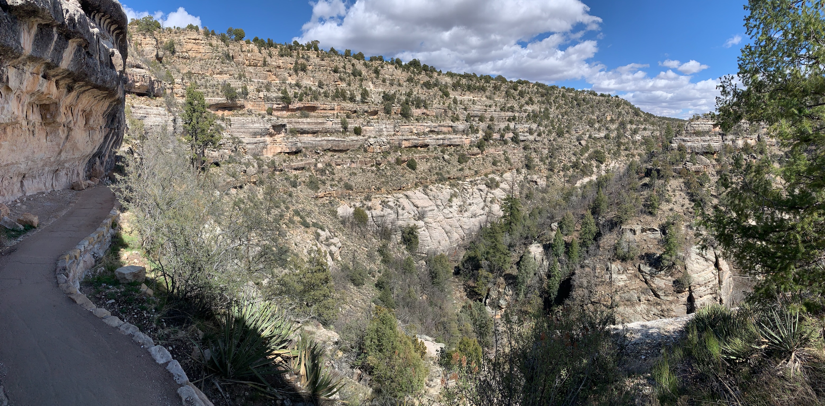
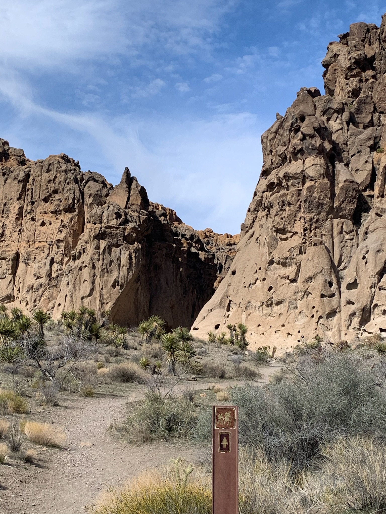
With a bit of hiking down into the canyon, you can walk right alongside many cliff dwellings and look across the canyon at more. The steps bring on a bit of vertigo and require extra breathing at around 6,500′, but the views are extraordinary. Plan ahead, since the Island Trail closes at 3:30 pm.
Both the alcoves along the trail and in the distance contain many cliff dwellings.
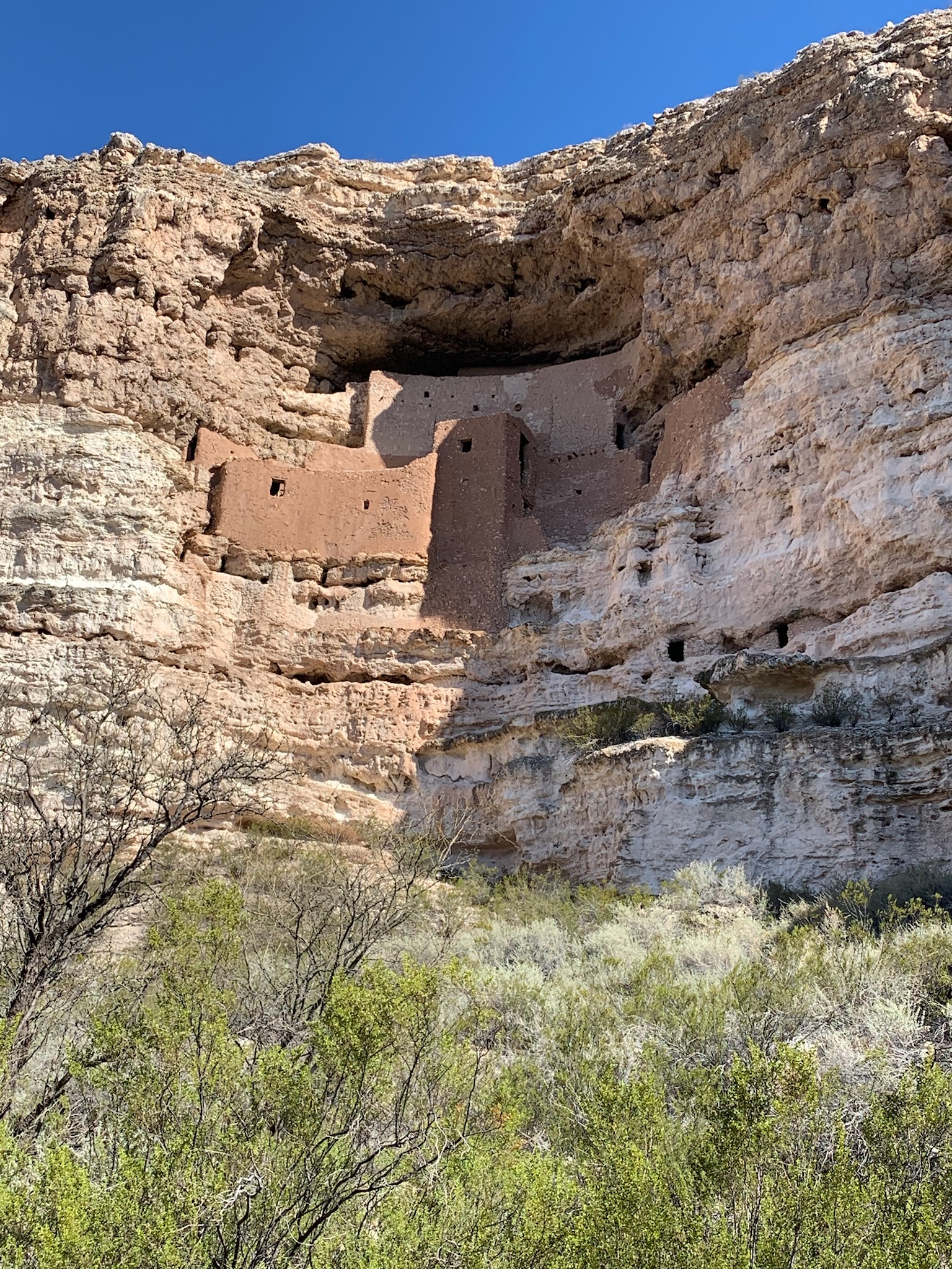
Montezuma was an Aztec who fought the Conquistadors in what is now Mexico. He had absolutely nothing to do with this place, which was built hundreds of years before he was born. Also, it was likely built for comfort and convenience, rather than war. Early tourists destroyed many cliff dwellings by taking home “souvenirs”, and many of the intact cliff dwellings show no signs of having ever been attacked by other tribes. The natural alcoves across the Southwest provided warmth in the winter, shelter from rain, coolness during summer, convenient places to cache items for trade and great hunting overlooks. I have to laugh at the so-called “mystery” of why early people built these cliff dwellings, especially considering the fancy modern hotels built into the canyons in Sedona. Why wouldn’t people want to stop when passing through, make themselves comfortable and move on when they wished?
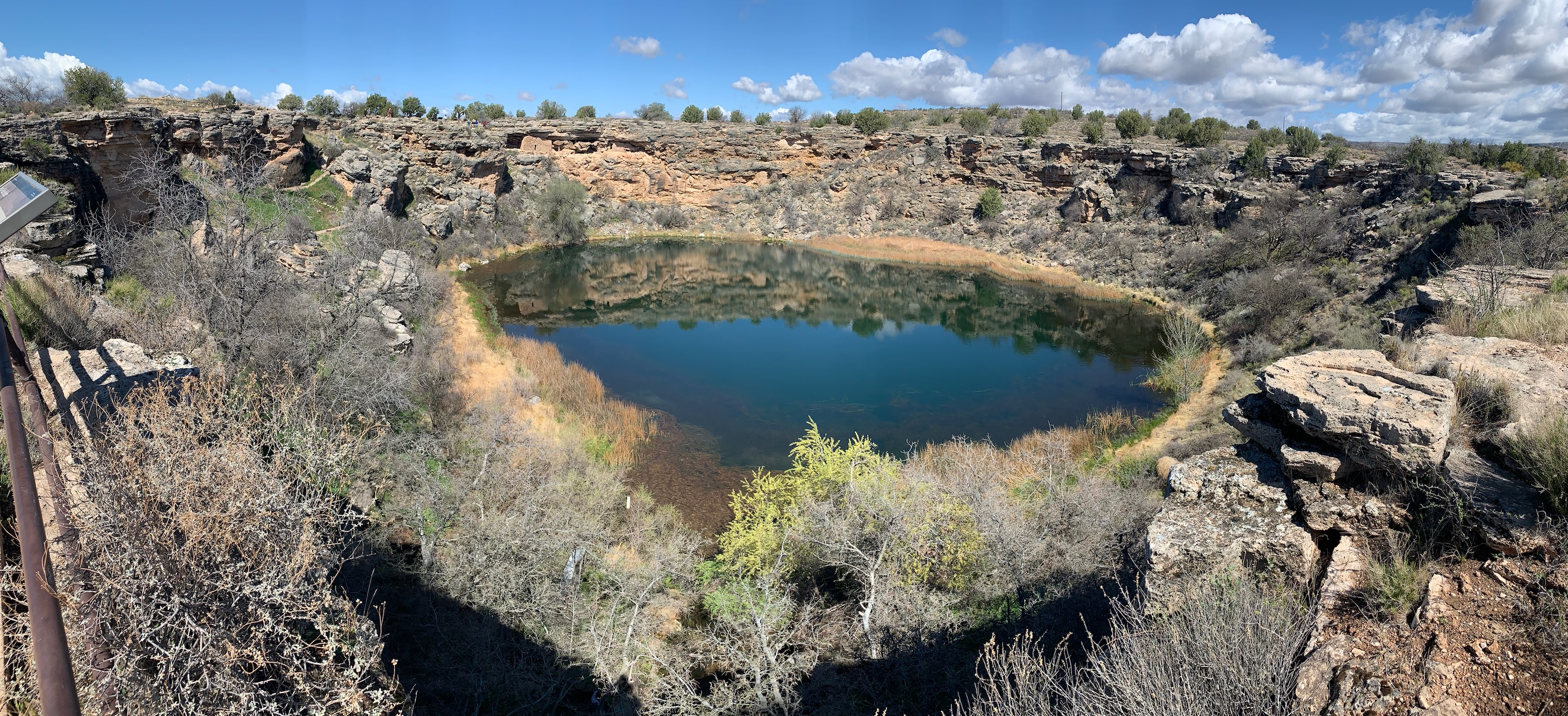
Montezuma’s Well is part of the same park unit and well worth a visit. There’s a closer view of the cliff dwellings, especially at the lower part of the well, ducks, and a still functioning irrigation channel.
Fed from underground, the well maintains a constant water level. Unfortunately, there are trace amounts of naturally occurring arsenic in the water, a reminder that nature never makes it too easy.
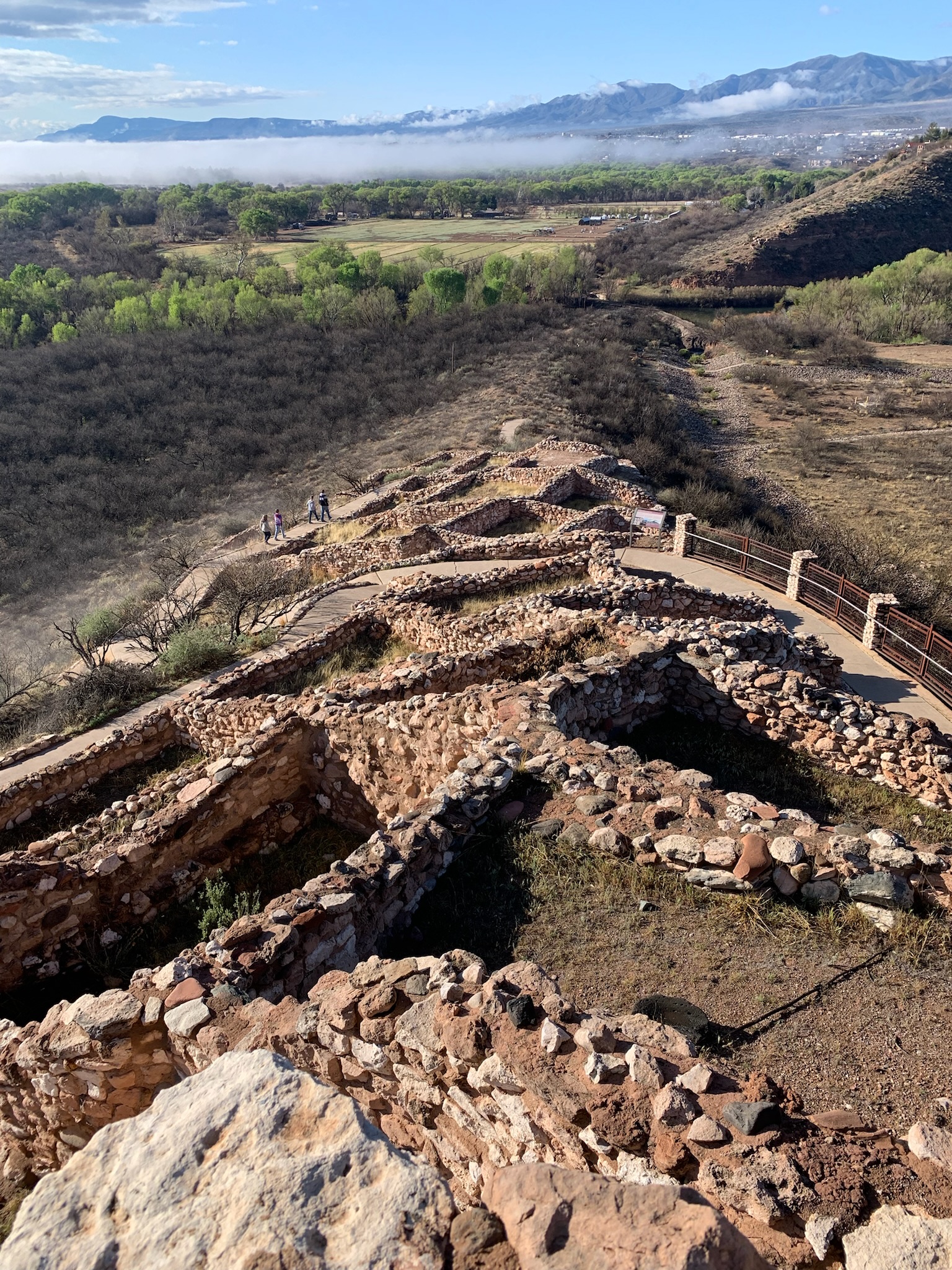
My recent trip started at this impressive hilltop pueblo overlooking the Verde River valley in Arizona. The ancestors of several different Native American tribes migrated through the Southwest over centuries. Each site provides another glimpse into this fascinating history.
While it looks like my photos never include people, they often do, if only for scale.
I enjoy revisiting parks now that I travel by electric vehicle (EV), but this one was particularly good. When Pinnacles was still a National Monument before 2013 and I still traveled by burning carbon, we took the kids, but our timing was a bit off. Pinnacles gets crowded on weekends with full campgrounds and limited parking at trailheads. And the seasons are tricky. Winter can be too cold with icy roads in the hills, and summer is too hot for me, especially with our new and changing climate. Spring break is popular, and the campground pool opens on April 1st this year. Last time, we experienced both too many crowds and too much heat. After a bit of research, I decided to go mid-week at the beginning of Spring.
The biggest difference is visiting the caves at Bear Gulch. To protect the large, sensitive colony of Townsend’s big eared bats, it’s rare to be able to visit the entire cave. I remember being underwhelmed by the caves on our earlier visit and described it as being more like a narrow canyon with a few boulders stuck overhead, compared to other caves in the park system. So this time, I checked the status of the caves, and I learned that the last week of March often has full cave access, before the bat breeding season starts. And wow, it was a very different experience.
First, I hiked from the campground to save EV battery range and get more exercise. That turned out to be a beautiful hike through varied terrain with quail, wild turkeys, woodpeckers, jays, turkey vultures and other birds. But when the Gulch narrowed, I felt the cold air from underground, even before entering the lower caves. Last time, we must have taken the less-scenic shortcut. This time, I felt like a spelunker. By the time I got to the upper caves, my iPhone was in my breast pocket for light, because scrambling and ducking required both hands. It was more adventure than I expected, but fortunately, people along the way helped keep me on the path to the lovely small reservoir at the top. Well worth revisiting!
“An elf will go underground, where a dwarf dare not? Oh, I’d never hear the end of it.” — LOTR
I wrongly assumed that this preserve was just a flat sandy desert, but it is a varied terrain of mountains, mesas, canyons, and volcanic landscapes, in addition to sand dunes.
The Rings Loop Trail pictured, near the Hole-in-the-Wall visitor center, goes right through a canyon with Swiss-cheese holes in the walls. There are petroglyphs to see, fascinating views, and short ladders of iron rings to climb.
A couple of retired campers asked me about my long range Tesla 3. The recent spike in gas prices ($7 in California) interests people who regularly spend over $100 to fill their tanks. Of course it’s also a very fun car to drive with a low center of gravity and instant acceleration. But too many folks resist change, even when their carbon travel habits contribute to devastating change.
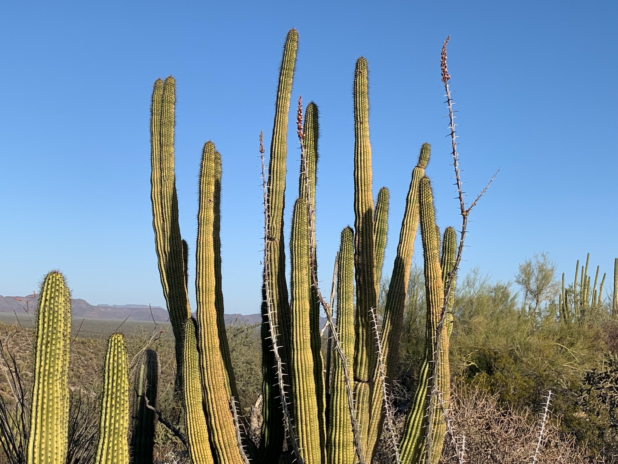
The skinny shrub reaching up in front of the cactus is Ocotillo, just beginning to bloom.
The ranger asked good questions. Given that we live in the Anthropocene or Human epoch, what exactly does wilderness mean to us now? This was one of my favorite ranger talks.
There’s a tiny endemic fish living in a corner of this park near the Mexican border. But because groundwater levels are now dropping sharply, the Quitobaquito pupfish’s natural habitat could disappear within a few years.
Some local school kids helped build a pond behind the visitor center to try to save the pupfish. The park service is re-lining the original Quitobaquito Springs to try to retain more water, but the springs are shrinking. People have been impacting the environment here for over 10,000 years, and, whether we like it or not, the little fish is now dependent on whether we choose to save it.
Ranger Kate asked the campers what we should do. The most common questions were about whether the Mexicans were at fault by siphoning off “our” water. They are actually on a different aquifer south of the Sonoyta River. And that jingoistic attitude really misses the point of being in an International Biosphere, next to the Pinacate y Gran Desierto de Altar Biosphere Reserve in Mexico. We’re supposed to be sister parks working together to save an internationally important natural area.
One suggestion was to “relocate the fish to a more viable habitat”. But if you take the pupfish out of Quitobaquito, are they still really Quitobaquito pupfish? Zoos don’t really prevent extinction in the wild.
I voted to add water to maintain the habitat. People think nothing of draining a river for a new golf course community and destroying ecosystems by burning fossil fuels. So why not reverse that destructive and short-sighted attitude and take this one chance to spend a few dollars to save a species?
We’re fortunate that Padre Kino wrote about the ‘Great House’ here in 1694, and that almost 200 years later President Harrison preserved the ruins. The O’Odham or desert people built the Hohokam or earthen buildings at some point over the two thousand years (at least) they flourished here, experts in canals and trade.
Today’s Gila River is tiny and dry, since most of its water has been diverted for Phoenix & Tuscon. With the climate crisis exacerbating drought, whole river valley ecosystems are turned to dust as we maintain golf courses and landscaping. Too busy and thoughtless to notice our destruction of the natural world, people drive air-conditioned SUVs to buy iced coffee, oblivious to the oblivion we cause.
No photo. Closed. Buried. Gone. No national park site. Just an article about Hohokam Pima National Monument. The archeologists covered their dig sites to protect the cultural heritage and have left nothing to see. And frankly, the public isn’t welcome here. The Gila River Indian Reservation doesn’t want tourists traipsing over the burial grounds of their ancestors. If you’re interested in their culture and artifacts, visit their nearby museum. And if you’re on some kind of quest to visit all of the national park units in the lower 48 states, then just be content with driving through the monument under the Goodyear Road overpass on I-10 between Phoenix and Tucson. Don’t stop. There’s literally nothing to see here.
The common meme here is that the eponymous trees remind folks of Dr Seuss, but the stars here are the lumpy rocks. Every time I turned around, I half expected the rock monster from Galaxy Quest to stand up. I took this panorama less than 50 feet from my campsite. Exploring around here brings back that childhood sense of wonder, and the actual kids I saw also enjoyed scrambling all over the weird landscape.
Also, the tree that inspired Dr Seuss for the truffala trees in his Lorax story was a Monterey Cyprus, not a Joshua Tree. But it’s not a bad idea to think about the Lorax when visiting any park, since we need to protect our trees more than ever now. And since I’m correcting the record on trivial items, Jumbo Rocks Campground site #113 has plenty of parking for a 15′ 5″ long electric vehicle. The site description says that the parking space is limited to 13 foot long vehicles, and coincidentally I’ve noticed more than once that it is the last campsite available. So, if you have an EV, go ahead and book the site. If you’re driving a gas-guzzler, stay home.
“It’s a rock monster. It doesn’t have motivation.”
Badwater Basin, 282 feet below sea level. Highest peak, Telescope, is over 11,000 feet and is snow-capped.
Death Valley National Park is a repeat park for me. I last came here with my kids when I still traveled by burning carbon. This time I hiked out into the basin, since the grand scale is difficult to comprehend from the parking lot. While a very few species have adapted to the extreme climate, humans can not live here during the summer. And yet every day we choose continued desertification of our planet over choosing to convert from fossil fuels.
“All in the valley of Death, rode the six hundred”