Best Park in the southwest: Big Bend NP in Texas. It has canyons, hiking, rivers, wildlife, views and it takes at least 2-3 days to see it properly. But go around winter, as it’s becoming dangerously hot much of the year.
Best State in the southwest: New Mexico. Some of the best natural wonders and native cultural sites in the country.
Best Culture: New Orleans Jazz NHP. Get the ranger to play some of Louis Armstrong’s old trumpet recordings. And then go out, explore, eat, drink and find some live music.
Best National Trail: Butterfield Overland Stage. Although it only ran for a few years, it cuts near the Mexican border through many fascinating historic sites.
Best Native Ruins/ Sacred Sites: Chaco Culture. Tough to get to. Unforgettable.
Best Paddling: Big Thicket. Slalom your kayak through the swamp. Glorious!
Best Recreation: Hot Springs NP. Take a hike or go shopping, if you like, but try to find a place to soak in the old style. Relax and enjoy!
Best Wildlife: Padre Island NS. Hike or better paddle along the shores and count the different species of birds.
Best World Heritage Site: Taos Pueblo. One of the oldest continuously inhabited places in the US.
Three historic trails pass through the state: Butterfield, Santa Fe and the Trail of Tears. A small part of Fort Smith too is on the Oklahoma side of the Arkansas River. Oklahoma may not have as many parks as other states, but it is beautiful and moving.
There are only three NHAs in the Southwest Region, two in Louisiana and one in New Mexico. While not official park units, they are uniquely interesting and beautiful areas to visit.
Atchafalaya National Heritage Area in Louisiana runs from the Natchez NHP and Natchez Trace NST, down past Lafayette and Baton Rouge, to the Gulf Coast west of New Orleans. Culturally, the focus is on the Acadians or Cajuns. 150 years after settling Acadie, now Nova Scotia, the French speaking Acadians were expelled by the British beginning in 1755. Longfellow wrote his epic poem Evangeline about the tragedy. Skilled fishermen and wetland farmers, many settled in French Louisiana, growing rice, beans and catching crawfish. They mixed with Native Americans, slaves, freed blacks and other immigrants, but kept their French roots. The French pirate Jean Lafitte, a successful smuggler in the area, was captured, but offered to help the Americans in the War of 1812 in return for his freedom. Lafitte knew the swamps (waterlogged land) and the bayous (shallow waterways through the swamps) expertly, and Andrew Jackson employed him as his aide-de-camp. Lafitte also provided troops, cannon and ammunition. The Battle for New Orleans was won, and Jackson was credited as the hero. Lafitte was likely responsible for defeating the superior British forces, but he received no credit from the US military, just a pardon. But the Cajuns still thrive here, and their history and culture is preserved at the Jean Lafitte NHP & Preserve, which includes three different Cajun Cultural Centers in the NHA. Their music, Zydeco, is from the French word for beans, “Les Haricots” (say it fast). And Breaux Bridge, of course, is La Capitale Mondiale de l’Écrevisse, or the Crawfish Capital of the World.
Cane River National Heritage Area is the other NHA in Louisiana, and it is best known for the well preserved plantations of the Cane River Creole NHP. However, the whole river area from Natchitoches between the national forests, down past the plantations is fascinating. This is the northern terminus of El Camino Real de Los Tejas, one of the Old Spanish Trails that runs through Texas, and there are state historic parks highlighting the forts and cultural sites that predate the Louisiana Purchase. I try to get lost at least a few times every visit to Louisiana, as there’s always something surprising to find and plenty of delicious food!
The Northern Rio Grande National Heritage Area in New Mexico is at the crossroads of both the ancient and old west. El Camino Real de Tierra Adentro connects Santa Fe to Mexico City. The Old Spanish Trails connect Santa Fe to Los Angeles, and the Santa Fe Trail connects Santa Fe to St Louis. Route 66 goes right through town. And before they were Spanish, they were all Native American trading routes. The natives once expelled the Spanish during the Pueblo Revolt, planned at Pecos. There are caves and Petroglyphs showing where people camped. Bandelier with its tall ladders to cliff dwellings is also in the NHA. But it’s not just history. Taos Pueblo (above) is still occupied today, continuously for over 1,000 years. All this I had seen, but then I got lost again, taking an improbable route through the mountains towards the headwaters of the Rio Grande in Colorado. And there are canyons, gorges, wild and scenic rivers, Georgia O’Keefe’s ranch, more cliff dwellings & petroglyphs, and even more storied trails. Some of my most memorable scenes of America are on the drives between official sites, intangible culture, storied heritage, true wildlife, and sheer beauty on the road not often taken.
Quick logistical update: until summer, Mondays are Mexican World Heritage Sites, Thursdays are eclectic, and Saturdays are bonus park photos. I took the photos above yesterday in New Mexico and Colorado.
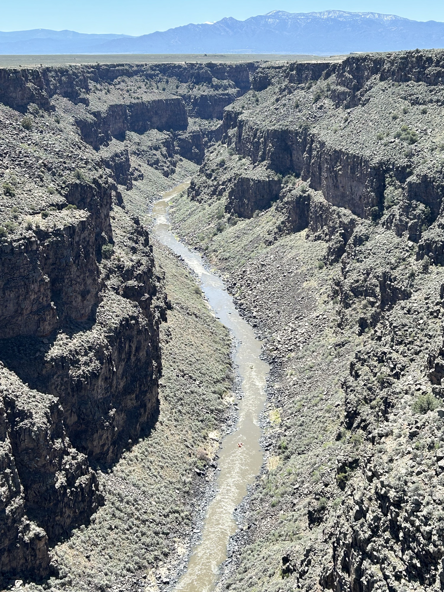
While technically in different regions, both National Heritage Areas are linked by the river, the mountains and our cultural heritage. The Rio Grande begins in the San Juan Mountains in south central Colorado and flows east through the San Luis Valley where it turns south into New Mexico. The scenic north section is called the Río Grande del Norte to distinguish it from the southern section that defines the Texas-Mexico border. The river flows through the Rio Grande Gorge and is now popular for whitewater rafting (see three rafts above left). In the distance are the Sangre de Cristo Mountains (both photos).
Native Americans and Spanish explorers traveled up and down the river, settling on the fertile valleys. The native land was claimed by the Spanish, Mexicans, and Texans, and for a dozen years, the Río Grande del Norte defined the US-Mexico border in Colorado, before the US claimed the land all the way to California by treaty in 1848. In the Civil War, Texas secessionists battled Colorado volunteers at Glorietta Pass in New Mexico to decide the war in the southwest.
The Northern Río Grande National Heritage Area in New Mexico celebrates this magnificent natural scenery and the cultural heritage it guided. It also includes Taos Pueblo, wild & scenic rivers, historic trails, scenic byways, and several cliff dwellings. Much of the land is also a BLM managed National Monument. The area is both beautiful and fascinating, and I was not going to miss another chance to drive through on my way northeast.
The Sangre de Cristo Mountains tower over the east side of the Río Grande del Norte from east of Santa Fe NM up into Colorado past the Great Sand Dunes. Meaning ‘blood of Christ’ in Spanish, the name likely refers to the scarlet colors of the mountains at sunset. The helpful illustration (my favorite photo above right) is on the Stations of the Cross trail up to a church that overlooks the historic San Luis Valley.
The Sangre de Cristo National Heritage Area in New Mexico borders the Northern Rio Grande National Heritage Area in Colorado, and includes the Cumbres and Toltec Scenic Railroad featured in Indiana Jones and the Last Crusade, the Monte Vista National Wildlife Refuge famed for Sandhill Cranes in March, and Fort Garland, a fine restored Kit Carson fort with an interesting museum on Buffalo Soldiers—one turned out to have been a woman who served for years as a man undetected. The area is lovely and pastoral amid snow-capped mountains, with many other worthy attractions, but I’m on the road again.
The last American concentration camp to close was Rohwer, Arkansas, deep in the delta near the Arkansas Post. There’s an echo of history, since that site is part of the Trail of Tears, when another group of Americans were forcibly removed from their homes unconstitutionally and sent to live in government reservations. The vast camp soon returned to farmland, so little remains besides the cemetery above. Several of the graves mark infants and elderly inmates. The monument to the right is to the 442nd Regimental Combat team, the most highly decorated unit in US military history. They served in Europe, while their families were imprisoned.
The neighboring town of McGehee maintains the excellent WWII Japanese American Internment Museum about both Rohwer and Jerome. The sculptor Ruth Asawa was imprisoned here. Another inmate at Rohwer was a 5 year old boy named George Takei, who later played Lt. Sulu on the original Star Trek.
“And it became normal for me to go to school in a black tar-paper barrack and begin the school day with a pledge of allegiance to the flag. I could see the barbed wire fence and the sentry tower right outside my schoolhouse window as I recited the words, ‘with liberty and justice for all’.”
George Takei, speech at the museum on 16 April 2018
Jerome was the last American concentration camp to open and the first to close, as it was converted into a POW camp for Germans. The military acquired the land as a result of a tax default, and over 8,000 Americans of Japanese descent were incarcerated here in the southeast corner of Arkansas, deep in the Mississippi Bayou. The Governor of Arkansas insisted that none of the prisoners be allowed to remain in his legally segregated state after the war and that all of the guards be white. When it closed, the prisoners here were mostly transferred to the other camp in Arkansas, with some sent to Amache, Gila River and Heart Mountain; ‘trouble makers’ who protested had already been sent to Tule Lake. Besides the monument above, there is a deteriorating old smokestack from the infirmary visible in the distance to the right. Nothing else remains, and the land is now a working farm.
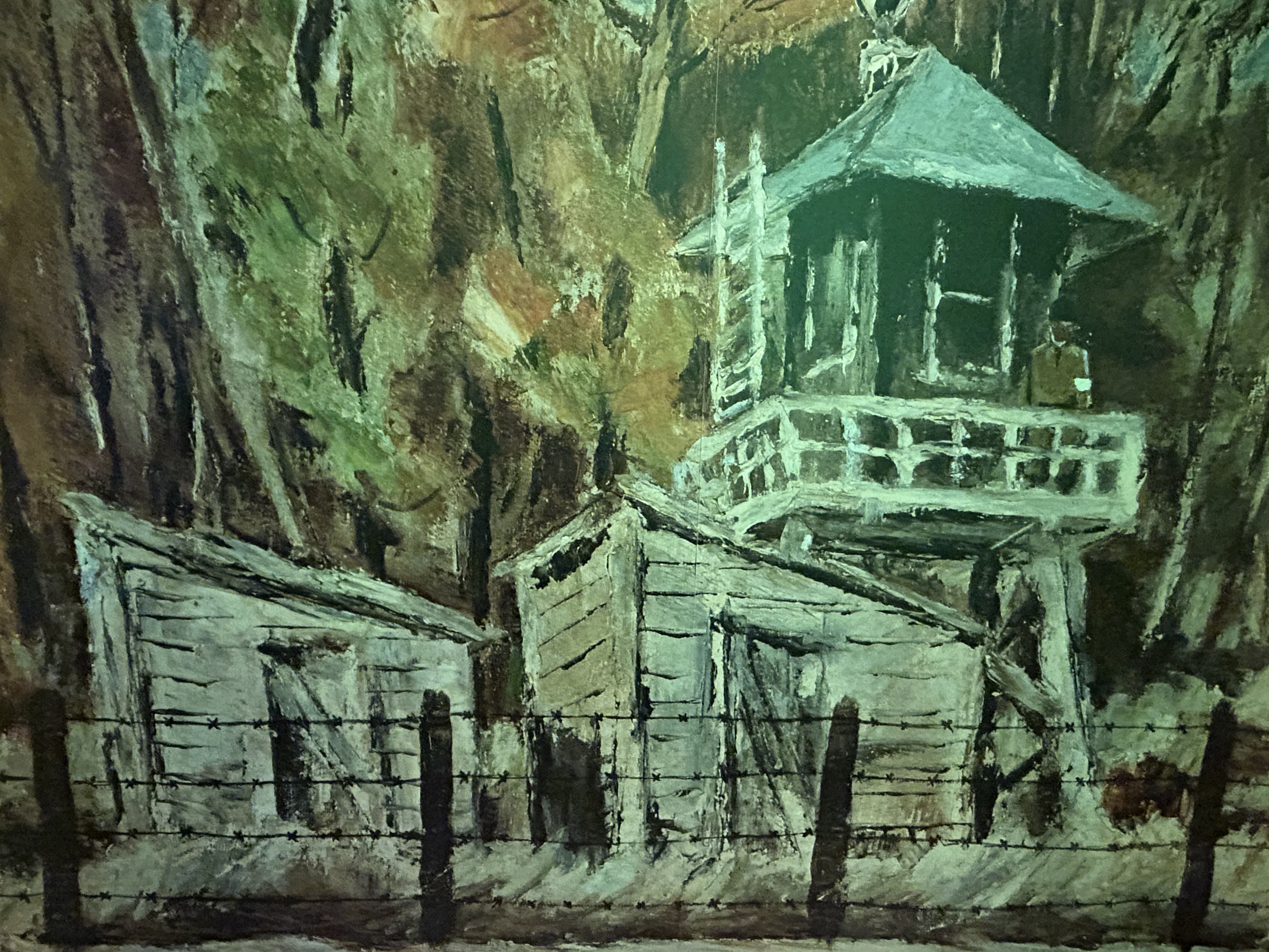
Nothing except a shameful unconstitutional history, a duty to be better Americans, and memories. Below is detail from a painting by Henry Sugimoto showing how he remembered his time at Jerome. The painting is on display with many other exhibits at the WWII Japanese American Internment Museum in McGehee about 20 miles north. The museum is excellent, open Thursday to Saturday, and is the result of talented, caring and dedicated townspeople working to preserve this important history without federal funding.
I recently completed visits by EV to all the national park units in the southwest, including 2 in Oklahoma, 4 in Louisiana, 7 in Arkansas, 14 in Texas and 15 in New Mexico. I’ve also visited the southwest biospheres and heritage areas. Here’s a summary of each state with my favorites.
Oklahoma is a beautiful state where many Native American tribes were forced to live and where many famous singers emerged, including Woodie Guthrie, Reba McEntire, Toby Keith, Roy Clark, Carrie Underwood, Vince Gill, Blake Shelton, Patti Page and many more. The Chickasaw Recreation Area is good for nature hikes and borders the fascinating Chickasaw Cultural Center. Washita Battlefield is a difficult site to visit, since it is covers a shameful episode in US history. My report turned into a rant after a park service employee dramatically exaggerated the numbers of white settlers killed in native raids, despite sitting outside the park bookstore which revealed lots of white fear but very few documented killings in historic records. The only affiliated park in the southwest is the Oklahoma City National Memorial.
Louisiana also has important history that must never be forgotten, from prehistoric Poverty Point, to the Cajun culture in Jean Lafitte Park, to the haunting plantations at Cane River Creole and to the birth of uniquely American music in the New Orleans Jazz. The accents, architecture, atmosphere, food, music, scenery, stories and style of the state make it unforgettable. If you’ve never been, go and stay awhile. If you’ve been, go again.
Arkansas styles itself as the natural state—true based solely on armadillos—, but the parks are mostly historic. Early French settlers at the Arkansas Post traded with the natives for furs from the Buffalo River. Later Fort Smith was a critical junction on the Trail of Tears, and Pea Ridge was the site of a key Civil War battle. More recently, Bill Clinton was born here, and Little Rock High was integrated in the face of racism. Even Arkansas’ National Park, Hot Springs, is a throwback to an earlier era. This is one of the few states I hadn’t really visited before starting this quest, but now I know better what an interesting state I was missing.
Texas has a lot of big beautiful parks to enjoy nature: two National Parks, Big Bend (see photo) and Guadalupe Mtns, two recreational lake parks, Amistad and Meredith, along with Big Thicket, Padre Island and Rio Grande. There are also two sites tied to prehistoric man: Alibates quarries and Waco Mammoth. San Antonio Missions predate the US, and Palo Alto Battlefield predates Texas. Fort Davis shows frontier conflict with natives, and Chamizal demonstrates border cooperation with Mexico, as approved by LBJ. Besides all that, Texas has many of the best state parks in the country, with top rate rangers, facilities, activities and scenery.
[Sorry to hop around so much, but I want to wrap up a region]. Last year folks celebrated the 50th anniversary of the river’s designation, but somehow Arkansas allowed a concentrated 6,000 hog feeding operation on Big Creek to pollute the Buffalo River with runoff from tons of pig crap. The resulting increase in algae and e-coli bacteria was damaging water quality in the park significantly. After protests, the hog operation was halted (and paid off handsomely), but local politicians have not been willing to make the ban permanent.
I woke in Tyler Bend Campground all ready to paddle 10 miles of the middle section from Baker Ford to Gilbert (where someone from the General Store would leave my car), but a sudden line of thunderstorms dissuaded me. That storm system killed three people in Texas with tornadoes and brought lots of lightning to this river in Arkansas, so I was glad to hit the road early instead. Pollution from either industrial ranching or fossil fuel burning is taking the fun out of some of my best trips.
Despite rural development—like Branson—, the Ozarks are still very beautiful, and the river is 135 miles of free-flowing nature. Nearby there’s a 100 foot wide natural bridge, one of many alcoves and interesting geologic features in the area that likely caused the French trappers to describe the area as having arches or “aux arcs” (say it out loud).
Americans, being poor linguists and unaware of the remote arches and bridges upstream, have long been confused about the origin of the name “Ozarks”, speculating that the French were talking about natives with curved bows or some bend in the river. This is moronic, as all bows and rivers are curved, so the French explorers would have no reason to use such a useless description. Americans had similar problems in understanding the French name for the Canadian River, which obviously derived from the Spanish word cañada, as the river passes Texas’ Palo Duro, the second largest US canyon. Rather than try to understand foreign languages, Americans assumed the French explorers did not know how to Canada by river.