All Southeast Sites *

The southeast region has more park units (70) than any other region, and I have visited all the units—*except 6 in US Caribbean territories—including all the affiliates, heritage areas and trails in Alabama, Florida, Georgia, Kentucky, Mississippi, North Carolina, South Carolina and Tennessee. Given the large number of states and parks involved, the summary below is organized by theme.

Natural Areas

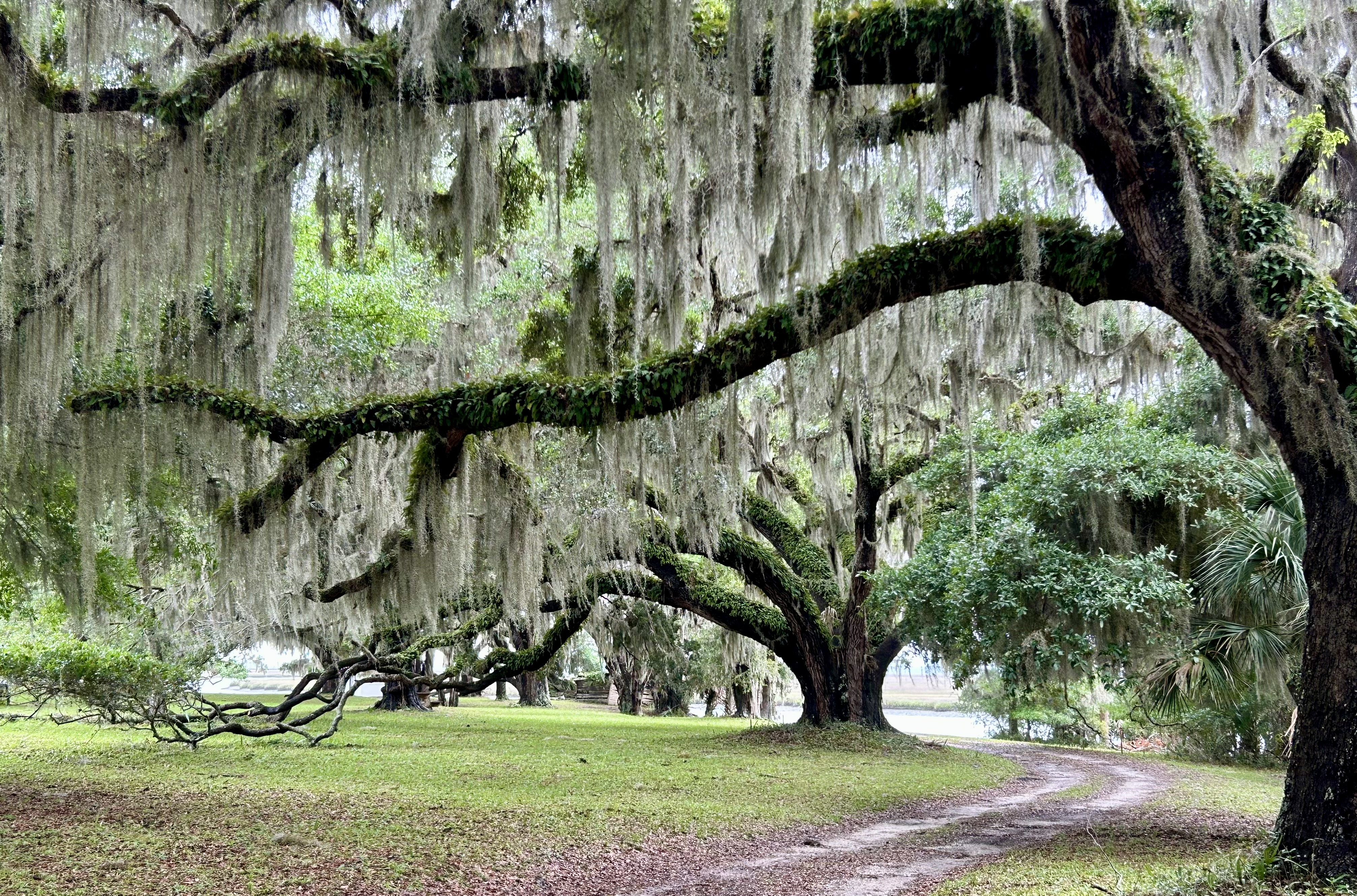
All of the National Parks in the southeast preserve natural areas, including the reef area of the Florida Keys from Biscayne to the Dry Tortugas, the lowlands of Congaree and the Everglades, the Great Smoky Mountains, and even underground at Mammoth Cave. Other park units, Canaveral, Cape Hatteras, Cape Lookout, Cumberland Island and the Gulf Islands, protect barrier islands. Big Cypress, Big South Fork, Chattahoochee River, Little River Canyon and Obed River all protect diverse riparian areas.

Pre Civil War

Ocmulgee Mounds, Russell Cave and Timucuan stretch back before history, but Horseshoe Bend covers a tragic event in Native American history. Several sites cover early colonial history, including Castillo de San Marcos, De Soto, and Forts Caroline, Frederica, Matanzas and Raleigh. Cowpens, Guilford Courthouse, Kings Mountain, Moores Creek and Ninety-Six cover the Revolution. Blue Ridge, Cumberland Gap, Lincoln Birthplace, Natchez HistoricParkwayTrace, and Pinckney, trace the path of history in the southeast, culminating in the war to abolish slavery.

Civil War and beyond

Andersonville, Brices Cross Roads, Camp Nelson, Chattanooga, Forts Donelson, Pulaski and Sumter, Kennesaw Mountain, Mill Springs, Shiloh, Stones River, Tupelo and Vicksburg are Civil War sites. Johnson, Reconstruction, and Tuskegee Institute cover post war struggles. Carter, Sandburg & Wright Brothers are historic highlights. Birmingham Civil Rights & Freedom Riders, Emmett Till, MLK, Medgar Evers, and Tuskegee Airmen reveal the continuing struggle for Civil Rights.

I learned more traveling in the southeast than any other region, as the area is so rich in history and culture. And the preserved natural areas include some of my favorite park experiences, from underwater and underground, to rivers and shores, and to wildlife experiences in mountain forests. And they can all be explored without traveling in a carbon-burning vehicle.

North Carolina in Photos

Celebrating completing the Tar Heel State!

Above are the Blue Ridge Parkway (also in Virginia), Cape Hatteras NS, Cape Lookout NS, Carl Sandburg Home NHS, Fort Raleigh NHS, Guilford Courthouse NMP, Moores Creek NB, and Wright Brothers N Memorial. Appalachian NST, Great Smoky Mountains NP (also in Tennessee), Overmountain Victory NHT, Trail of Tears NHT, Blue Ridge NHA, Gullah Geechee Cultural Heritage Corridor, and the Southern Campaign of the Revolution NHC are here too.

South Carolina & Southern Campaign of the Revolution National Heritage Corridors

These are two obscure heritage areas in the Carolinas, but none of the state or national park employees I spoke with had heard of either. While the South Carolina NHC has historic sites, plantations and gardens, the parks included—like Pinckney, Sumter, and Overmountain Victory—are unrelated. And while the Revolution NHC includes Moores Creek, it excludes many other important battles in the Carolinas and neighboring states. Don’t waste time following these confusing corridors, but instead start with an overview at historic Camden.

Here’s the story of the Revolutionary Campaign in the southeast, focusing on national sites and affiliates. Virginians Henry, Jefferson and Washington led their colony into rebellion, in concert with the north. Virginia colonial governor Lord Dunmore called in troops, organized loyalists and even formed a regiment of liberated slaves. Echoing Bunker Hill, Patriot militia fought well at Great Bridge in 1775, prompting Dunmore to order the shelling of Norfolk Virginia. Echoing Concord, the Patriots cut down a broadsword charge at Moores Creek North Carolina in 1776. And at the end of 1778, the Patriots took Savannah, followed up with a victory at Kettle Creek Georgia in early 1779.

But in May of 1779, the British sacked Portsmouth in Virginia, kicking off their southern campaign in earnest. In late 1779, the British returned to Savannah, capturing it after a siege. In early 1780, they took Charleston SC after another siege. Next, they turned their attention inland, hoping to sway more loyalists, keep their large southern colonies, and then take the fight back to the northeast. In 1780 the British fought over a dozen battles around Charleston and Camden (see Cornwallis’ HQ below) in South Carolina, consolidating their control over the colony.

But the British were ruthless in the south, revoking pardons, burning homes & farms, and imprisoning or hanging those who wouldn’t sign loyalty oaths. The most infamous example happened in May 1780 at Waxhaws—named after a local tribe—, when Banistre Tarleton massacred Patriots, inspiring further rebellion. Popular resentment against the tyrannical British grew, especially among the Scots-Irish settlers. After Gates lost his leadership position after failing at Camden, Nathaniel Greene began a much more effective guerrilla campaign in the back country.

The Patriots didn’t win all their battles, but many of the British victories were Pyrrhic, causing them to cede territory even after eking out technical victories. The back country belonged to the Patriots, especially when reinforcements crossed the Appalachian Mountains on the Overmountain Victory Trail. The Patriots won at Kings Mountain in late 1780, then again at Cowpens in January 1781.

Even though the British subsequently won at Petersburg VA, Ninety-Six in SC, and at Guilford Courthouse NC, clearly, they were not winning the broader campaign. Cornwallis brought his troops north to Virginia. After a close battle near Camden, the remainder of the British forces retreated for Charleston, with the last battle in the southeast fought at Eutaw Springs in September 1781. The denouement was set for Yorktown.

Overmountain Victory National Historic Trail

The trail stretches from Virginia, through a corner of Tennessee, south through North Carolina and into South Carolina at Cowpens and Kings Mountain (below). Revolutionary War re-enactors and enthusiasts follow parts of the trail on foot and by car annually, ever since some Boy Scouts walked the whole length in 1975. I’ve crisscrossed the area, and it’s beautiful country with whitewater rivers and some steep mountain slopes. Both the Appalachian Trail and the Blue Ridge Parkway cross and run along near the trail, and the Biltmore Estate is near the middle.

Many of the colonial settlers in the highlands here were descendants of Scots-Irish lowlanders, and their families still held grudges against the British, especially those who fought to extend the Empire by force. The British sent officers to the Carolinas to bribe and intimidate their subjects to remain loyal to the crown. They sent mercenaries, regular soldiers, and raised local militias to threaten settlers, particularly in the foothills. Their heavy-handed tactics provoked the Appalachian settlers. One particularly offensive leader was Major Patrick “Bulldog” Ferguson, who had ordered the bayonet slaughter of sleeping Patriot troops at Little Egg Harbor, NJ. He also designed the Ferguson rifle, a breach-loading rifle, and was wounded in the right arm in the Battle of Brandywine against General Washington, after which the British took Philadelphia.

The trail commemorates the pursuit of Ferguson’s army from north to south, by the citizen militias that rose up from Georgia, Tennessee, Virginia and the Carolinas against the overbearing British threat, culminating at Kings Mountain. Immediately before and after the events of the Overmountain Victory, the Patriots also won decisively at Musgrove Mill and Cowpens, respectively. These Appalachian Patriots turned the course of the Revolutionary War.

Normally, high ground is superior during fighting, but the ridge at Kings Mountain is steep, fairly straight and narrow. Once the patriots managed to get on both sides, the British became easy targets on top. Ferguson was shot off his horse, shot a young soldier asking him to surrender, and was finally shot multiple times and urinated upon before being buried in an unmarked grave where he lay. A headstone was later placed in the woods not far from the large monument at Kings Mountain below.

Cape Lookout National Seashore

The ferry pilot told me that this is the best view of the Cape Lookout Lighthouse, so there you go. Seeing wild horses was quite simple at Shackleford Banks, as there aren’t many places to hide. And the horses don’t seem to mind photos while they’re grazing.

A few decades ago, I came through the Beaufort Inlet on a boat to resupply. The docks and front street of Beaufort NC—not to be confused with Beaufort SC—haven’t changed much, although everything is quite a bit busier and pricier now. I don’t remember seeing any horses, although we knew they were there.

Unlike the rest of the Outer Banks to the north, Cape Lookout’s barrier islands have no paved roads. A few fishermen and visitors bring cars over on a vehicle ferry from Davis to Great Island Bay, and there’s another vehicle ferry from Atlantic to beach camping on North Core Banks. There’s also a passenger ferry from Ocracoke to the north end of this seashore at Portsmouth Village. And concessionaires run ferries both from Beaufort to Shackleford Banks and from Harkers Island—where I left from—to both Shackleford and the lighthouse. Yes, that’s five different ferries from five separate locations to five disconnected destinations, depending on your plan.

The seashore is quite casual, parents with babies, school groups, many folks bringing their dogs, tourists looking in the light keeper’s house, campers, sporty teens, and some older folks appreciating the natural beauty while reminiscing. The beaches have many shells, and you are allowed to take a few home. Many boats cruise around the bays from nearby marinas tucked into the coast’s rivers, and I heard several small planes going overhead. I drove up when the Harkers Island visitor center opened, got a ticket, hopped off on Shackleford, hopped on the next boat for the lighthouse, hiked around a bit and returned to find some seafood. Of course there are miles of beach to walk. Very pleasant.

Cape Hatteras National Seashore

There are three main outer banks—‘OBX’—islands in the park: Bodie, Hatteras and Ocracoke, from north to south. Each has a lighthouse: Bodie is currently open for climbing, Hatteras is tallest and Ocracoke is oldest. I brought my kayak and stayed at Oregon Inlet campground across from the Bodie harbor which has a kayak launch, but there was some construction, commercial traffic, and strong, cold winds in May. Also, since the islands are so long and thin, it’s easiest to see the main sights by driving the 70 miles, including the free vehicle ferry to Ocracoke.

Hatteras island is the biggest, with several year round towns and thousands of residents outside summer, when hundreds of thousands visit the OBX. The road gets damaged in storms, and wind often blows huge drifts of sand onto the road. Many of the residents have anti-Biden signs, which is counter intuitive, since he is trying to defend them from the Climate Crisis, which will steal their land, take over their businesses and even invade their homes. But they ignore the science, the melting glaciers and ice caps, the strengthening storms, the sea level rise and the increasing erosion. The lighthouse has already been moved many times. The OBX is one of the fastest growing real estate markets on the NC coast, worth tens of billions of dollars, even as homes are falling into the sea. Money appears inversely related to intelligence.

The delightful nature walk above is Springer’s Point Trail at the southern tip of Ocracoke nearer Cape Lookout, the northern tip of which can be visited by passenger ferry leaving from Ocracoke’s picturesque Silver Lake Harbor. There are some ‘banker’ (OBX) horses on Ocracoke, but they’re penned, not really wild.

Wright Brothers National Memorial

The boulder under the Osprey to the left marks the first flight takeoff, and the three stone markers under the right Osprey mark the first three landings. The fourth landing is marked by the white stone marker visible to the far right.

While the first flight happened here in North Carolina—at Kill Devil Hill near Kitty Hawk—due to favorable wind conditions and relatively soft sand, most of the work and final testing of a workable aircraft that could turn was done in Dayton. Inside the museum here you can see a full scale reproduction of the 1903 Flyer, and outside there’s a sculpture depicting the first flight. It’s a beautiful spot with a huge monument on the hill where they conducted gliding tests, and, yes, it’s still very windy.

Fort Raleigh National Historic Site

As befits any mystery, little remains of the fabled Lost Colony of Roanoke Island NC. There is a map, a cross and “CRO” carved in a post, archaeological remains, and various accounts, both trustworthy and not. The fort above is a reconstruction. The English brought explorers, scientists, soldiers and settlers here in a few journeys in the late 16th century, but the location was deemed a failure. There was little metal, poor soil and no deep water port, and several supply ships were lost in the shallows & storms. Most of the expedition returned to England.

It was however an excellent location for piracy with many hidden coves and inlets behind the barrier islands to wait for the Spanish treasure galleons riding the Gulf Stream back to Spain with stolen Aztec and Incan gold. Many of the last colonists here had wanted to land near Jamestown, but their pirate captain dropped them here instead. When war broke out between England and Spain, Queen Elizabeth kept all English ships at home to protect against the Spanish Armada invasion of 1588. So the colonists were abandoned by the Queen for years, while they were expecting supplies within months.

Likely, they became desperate and split up with a group traveling north and others initially staying behind to wait for help. There are reports that some armed men were killed in Native American skirmishes north of here, so those remaining must have decided to go to a nearby island to seek help from the Croatoans whose chief spoke some English and had been a guest of Sir Walter Raleigh in England for 6 months. The colonists were presumed dead by the English at the time, but much later reports of a few blue-eyed Croatoans suggest at least a few survived. And the cross and letters were likely a shorthand way of letting the English know where they were without letting the Spanish know.

I arrived too early to see the stage performance here which starts in June, and I declined to pay admission to tour the Elizabethan Gardens. But the rangers and museum tell the story, along with more stories about piracy—Sir Francis Drake raided St Augustine in 1586 and brought back some Roanoke colonists on his way home—, about the Freedman’s Colony of 1862 and more modern ventures. Coming from New England, I appreciate the efforts to honor our English heritage, such as the monument here to the first English child born in the Americas. Virginia deserves more credit for being the first English colony, after all, Captain John Smith named ‘New England’ after leaving Jamestown and mapping the north east coast. Still, it would be nice to have more information about what happened to the other ethnicities who lived here, especially the Native Americans.

Carl Sandburg Home National Historic Site

As a teen, Sandburg rode the rails in boxcars, like a hobo, to see the country, from Illinois to Colorado. ”I’m an Idealist.” He once wrote. ”I don’t know where I’m going, but I’m on my way.”

The prize winning poet & author enjoyed solitude in nature, and he bragged that his home up in the foothills here included “millions of acres of sky”. It’s a beautiful and peaceful spot with a fish pond and goats.

It is necessary now and again

for a man to go away and experience loneliness;

to sit on a rock in the forest and as himself,

”Who am I, where have I been, and where am I going?”

— Carl Sandburg

Moores Creek National Battlefield

As at the Old North Bridge in Concord, Patriots removed many of the bridge planks and greased the beams. Once the loyalists crossed, they found themselves surrounded by Patriots behind hastily built earth walls with muskets, one medium sized cannon and a swivel gun. The British-employed highlanders attacked with broadswords, which was the last time that tactic was ever tried. Here on February 27th, 1776 the Patriots won a clear victory in the War for Independence.

Normally, I would stop here, but the ranger expressed some views which were misleading and incorrect. The battle is described in the visitor center as America’s “first civil war”. The ranger described the Patriots as ”fake news” northerners and corrupt townspeople who hypocritically denied the people in the backwoods their rights while over-taxing them, using the Regulator rebellion of 1761 to support his argument. Which is poppycock.

Let’s start by noting that the battle took place before America was a country. The Patriots were British colonists in open rebellion, and the loyalists were British mercenaries and colonists paid to put down the rebellion. Any over-taxation and denial of rights was done at the behest of the British Governor, who used a variety of means to control the colony, including bribery, hanging, and dividing the colonists into factions. Without sanctifying the Patriots, some who owned slaves, or condemning the loyalists, some who had been forced to swear oaths, there’s simply no honest way to recast this colonial battle as civil war. The Regulator history is interesting, but it was a tax revolt and was neither a part of the Revolutionary nor Civil War.