


The photos above celebrate Wyoming’s great parks: Devils Tower, Fort Laramie, Fossil Butte, Grand Teton, the Rockefeller Parkway, and Yellowstone (more photos in that post). Bighorn Canyon is partly in the state, but my photos are in Montana. The Pioneer Trails and the Pony Express also pass through Wyoming, and Cody has a spectacular museum on Buffalo Bill, Native Americans and more, unrelated to the NPS.
Wyoming
Completed
Bighorn Canyon National Recreation Area
The choice is either to start at the dam in Montana and go up the canyon by boat or to start in Wyoming and take in the views from the rim. It was a long way for me to dodge power boats without easy stopping points, and the water level is obviously artificial. So, I chose to admire the views from above, passing through the wild horse refuge area and finding Devils Canyon Overlook above. I didn’t see any horses, but a turkey vulture flew right by my head so close the loud whoosh and sudden breeze startled me. Maybe he was hoping I’d fall over the extremely steep edge.
The topography of the area is disconcerting, as you see mountains & high ground and assume the Bighorn River would run south, but for all the uplift, the river has just carved its way deeper through the partially flooded canyon. Far upriver further south, it does the same thing, but there it’s called Wind River and cuts through Wind River Canyon. Ultimately, the basins and lesser mountain ranges in Wyoming matter far less to the river direction than the Rocky Mountains, which on this side of the Continental Divide cause the rivers like the Shoshone and Bighorn to flow east and north, joining here before flowing into the Yellowstone River on its way to the Missouri River. In the photo above, that flow is from the upper right to lower left, below the large shadow on the cliff across the canyon. The stretch of water in the upper middle, below the fans is Devil’s Canyon, partly filled by the dam’s backwash and sometimes fed by Porcupine Creek. The foreboding names match the inhospitable scenery. This is a rough and remote area, but it’s also starkly beautiful and dramatic.
Yellowstone National Park


Clockwise from top: Morning Glory pool, Daisy, Grand and Old Faithful geysers.
Most of the world’s geysers are here, near the country’s largest high elevation lake and the headwaters of the longest free-flowing river in the lower 48, in a park bigger than some states. For wildlife alone, this is my favorite national park, plus the geysers are my favorite geologic feature in a park. There’s a lot to see and do, but I’m not going to write more about it. Come see for yourself.
John D. Rockefeller, Jr. Memorial Parkway

The parkway runs along the Snake River (above) connecting Grand Teton and Yellowstone, but the park includes a 24,000 acre land & river corridor for wildlife, without which we couldn’t enjoy seeing as many migratory animals in the two famous parks. The Rockefellers were instrumental in a number of national parks, including Acadia, Smoky and Marsh-Billings. Despite opposition from local ranchers, they purchased huge tracts of ranch lands and donated them to us. Laurance Rockefeller later donated his family’s 1,000 acre ranch to become part of Grand Teton, and his Preserve Center there near Phelps Lake is the best place to get in tune with their legacy. Considering the damage being done every day by burning the oil that created their fortune, it’s really the least they could have done.
”How we treat our land, how we build upon it,
Laurance Rockefeller
how we act toward our air and water,
will in the long run tell what kind of people we really are.”
Grand Teton National Park
Oxbow Bend (above) is popular at sunrise as wildlife gathers in the coils of the Snake River and the light hits the Teton Range high on the right. Owls, a bald eagle, beaver and bugling elk all appeared out of the mist. Elsewhere in the park, pelicans, geese, ducks, osprey and many different small birds, then foxes and a large herd of bison wandered into view. Black bears foraging for hawthorn berries forced a trail detour, but I only saw scat.
Pronghorn migrate from here in Wyoming as far as New Mexico, and the headwaters from the nearby Continental Divide eventually reach the Pacific. This is an important park, ecologically, more than just a great photo stop. Still, the many lakes provide lots of flat hikes with steep mountain backgrounds, and lots of mountain hikes with water vistas. Or you could take the Jenny Lake boat across for even more views. Kayaking is a hassle with the permit & inspection process, and the views are wonderful on scenic drives and trails. Jackson Hole is crowded and expensive now, so look elsewhere for a place to stay.
Fossil Butte National Monument

Near Bear Lake, there was a much larger lake here during the Eocene around 50 million years ago, and there are many fossils of fish, reptiles, mammals and plants here. The one in the photo is a freshwater stingray. To help visitors get a sense of the timeframe, there are proportionately spaced signs from the entrance to the visitor center showing what evolved when.
We’re just the most recent to evolve, but we’re already driving a massive extinction wave, potentially as devastating as natural extinctions hundreds of millions of years ago. We take for granted the vibrant diversity of species, but even subtle changes can upset the balance and wipe most life off the earth suddenly. We evolved to overcome our limits, and now we need to learn how to control ourselves before we ruin the environment that sustains us.
Devils Tower National Monument
There are climbers in the photo on top of the leaning column on the left. I walked around whistling the theme from Close Encounters, but nobody seemed to get the reference. The area nearby is also beautiful, with a prairie dog town and lovely green and red valley with bison.
Fort Laramie National Historic Site
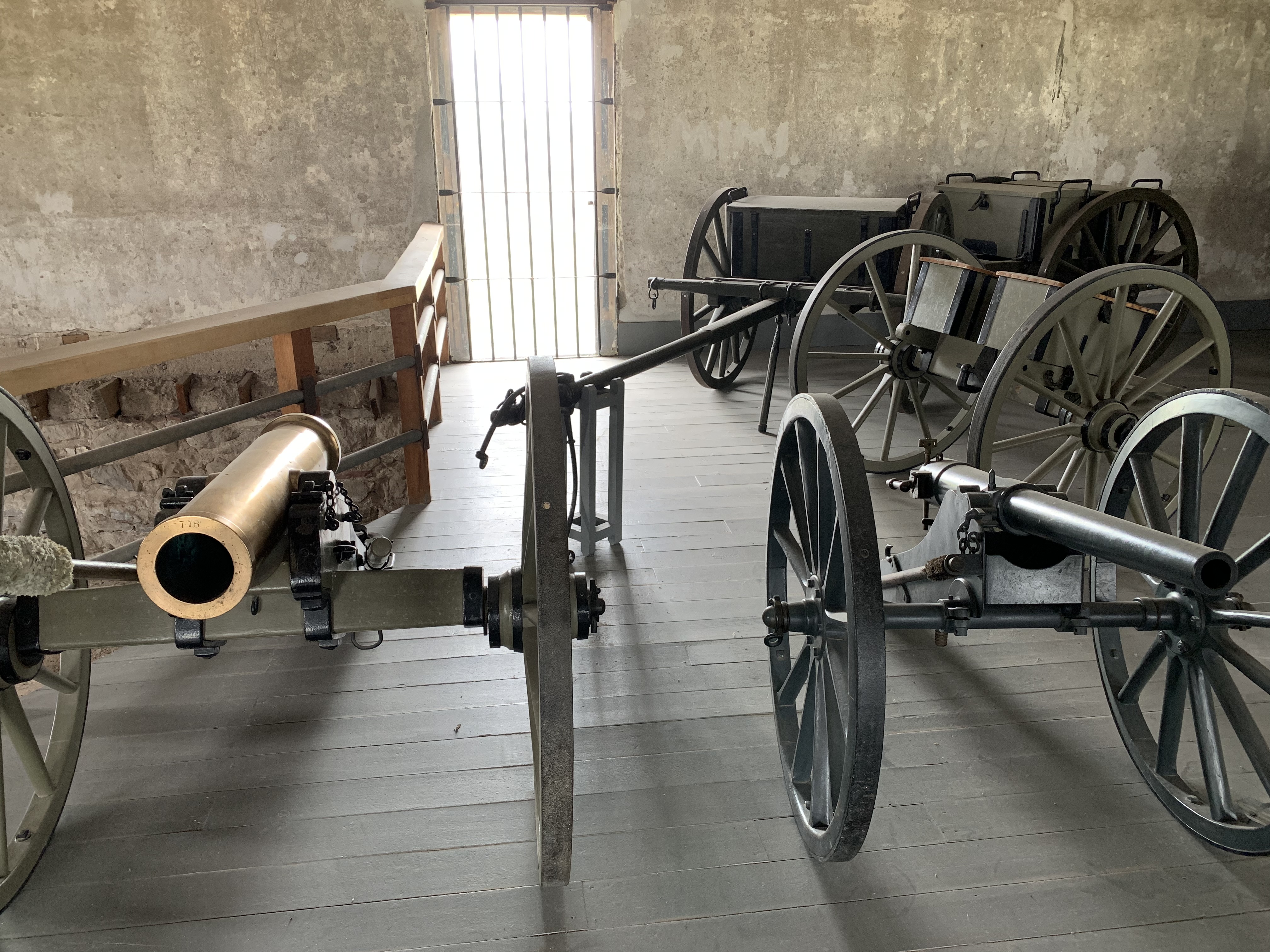
The site of two eponymous treaties, I ordered a sarsaparilla and talked history with a well-informed seasonal ranger. We decided that although the soldiers were sent out to protect pioneers, they were mostly bored silly, since the “attacks” were mostly myths or exaggerated stories. But the military leaders practiced diplomacy to try to avoid potentially deadly conflicts, and that didn’t always go well. Case in point, in 1854 a Mormon pioneer lady complained to authorities that a cow she lost on the trail had been caught and eaten by some natives who lived on the land while she was trespassing. Lt. Grattan was sent to arrest the offender (not the lady) with 29 soldiers. Apparently the negotiations were cut short when (most likely) one of the soldiers shot the chief, whose men subsequently killed all the soldiers. Several treaties were signed here, although they were not honored by the US. Ultimately, the US military ”solved the Indian problem”, by killing resistors with superior fire power, including the mountain howitzers above and Gatling guns, and driving the rest on to reservations. Four of these artillery pieces were used at Sand Creek.
