Luckily Lake Powell is high enough for the boat tour, which cost $145 and took 7 hours, including an hour hike, 30 minutes at the bridge above (see people bottom right for scale) and a beautiful song sung at the site by our Navajo guide. That’s far better than hiking overland for at least two days. At least Zane Grey (below left) had the sense to ride a horse. This is my favorite park to follow in his footsteps. The boat trip alone is marvelous, as Glen Canyon just gets more stunning the deeper you explore into Utah. But the canyon up to the monument is a delight too, with wildflowers, echoing cliffs & alcoves and a spring, allowing you a glimpse of a glen before the dam tragically flooded most of them. Before our Navajo captain navigated the twisting channel for the return trip, a brief shower brought at least half a dozen waterfalls down the towering rock walls. Spectacular!
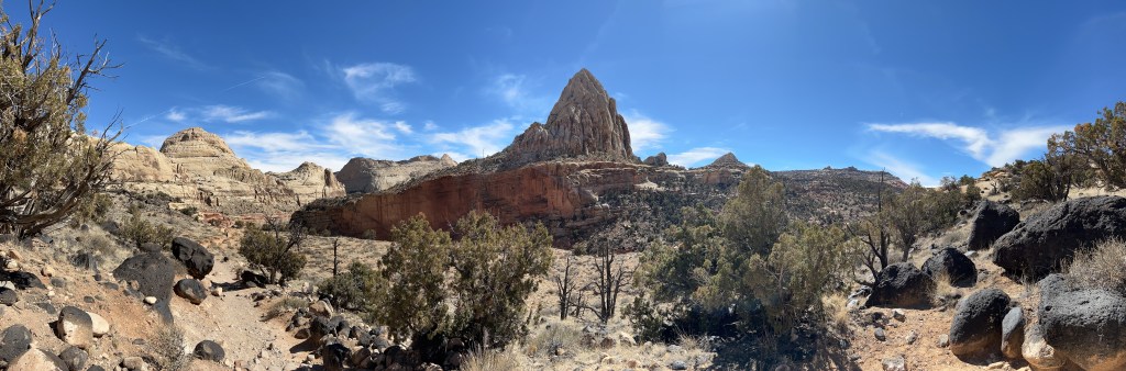
The dome in the middle reminded folks of the US Capitol, but the geologic speciality of the park is the reef, or Waterpocket Fold, one of the longest continually exposed monoclines (like a wrinkle) in the world, almost 100 miles north to south. Cathedral Valley in the north and Muley Twist Canyon in the south are difficult to access without a high clearance 4×4, but the geologic layers can all be seen in the middle cross section near the Fruita orchard. The Hickman Bridge trail above is a good place to see the dome, but the scenic drive along the fold is exceptional. The unpaved side trip into Capitol Gorge is particularly striking, and there’s a hike from the parking lot up to see the eroded round water-pockets for which the fold is named.
This is my favorite park to learn about the geology of the west, from the high country mountains like Great Basin and Rocky at 12,000 feet, to the high plateaus like Cedar Breaks at 10,000 feet and Bryce at 8,000 feet, to standing up country with Natural Bridges at 6,000 feet, Arches at 5,000 feet, Zion at 4,000 feet and the many layered Grand Canyon spanning from 8,000 to 2,000 feet, and all the way down to the low desert of Death Valley more than 250 feet below sea level. At Capitol Reef, the ranger’s geology talk explained how the changing climate and continental shifts over hundreds of millions of years left repeated layers of deposits, lifted them up unevenly and eroded them into the wonderful scenery we see today. The same patterns repeat, not just one ancient inland sea or forest or swamp or grassland or desert, but many repeated environments were slathered over one another and pressed into rock.
Why are there weird discolored greenish mounds along the Green River? Those were from one of the swampy periods (Morrison) when oxygen was low, materials were soft and clay-like and they contain late Jurassic dinosaur fossils. Why are there similar colored layers at much different altitudes? They were from different swampy periods and contain different fossils. What causes the alternating pink and beige layers of hoodoos and other rock formations? The layers are made of the same kind of rock, but in some years the iron oxidized and in others it couldn’t due to water changes. Where did all the sand come from to make all the sandstone layers? Much of the sand eroded from the old Appalachian Mountains, flowed down ancient rivers and blew across to the west.
Even if you’re completely uninterested in Geology, you might be interested in the outlaws who hid in the remote areas nearby, like the Wild Bunch, which included Butch Cassidy & the Sundance Kid. Or maybe tour the old orchard and learn about pioneers. Or take a moment to think of those Uranium miners, many Native Americans, who still suffer radiation poisoning, or think about the wildlife who can’t read the warning signs. This is an uncrowded and under appreciated national park. Highly recommended.
Although a neighbor to Arches, this park is very different. While the arches are easily approached by car and on foot, exploring the canyon lands requires long river journeys, multi-day backcountry camping, rock-climbing, mountain biking or challenging 4X4 drives. The three main sections, Islands of the Sky, Needles and the Maze aren’t even linked by 4×4 roads or hiking trails. Arches can be thoroughly explored in a single day or enjoyed in a couple hours. Canyonlands in entirety needs weeks, specialized gear, teamwork and planning.
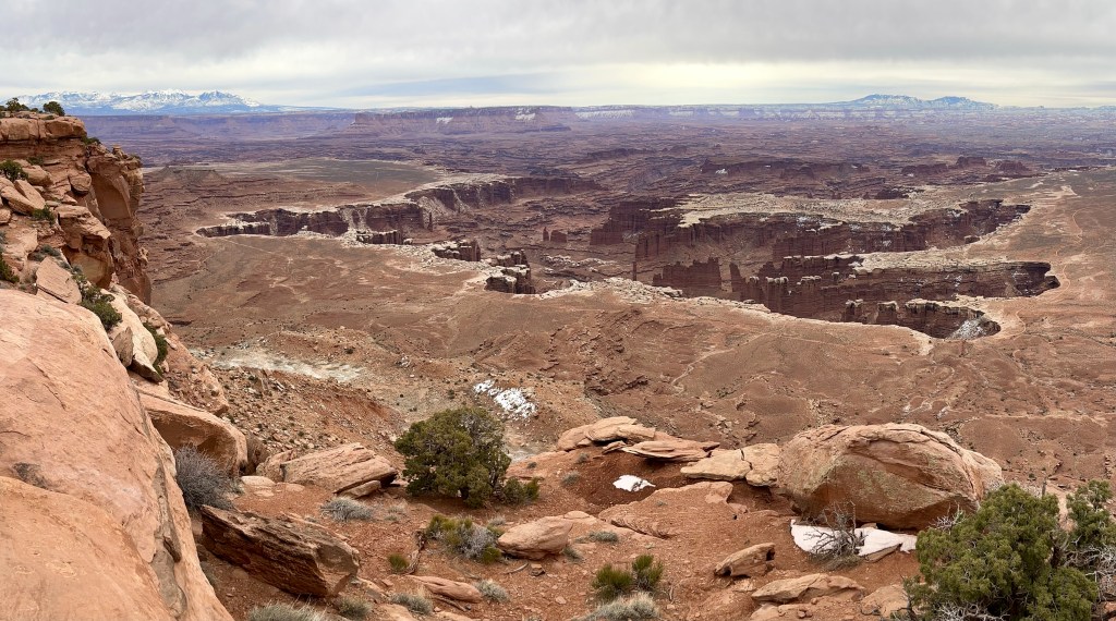
I’ve planned a half dozen different trips here, but so far I’ve only actually managed one superficial visit to peer down into the foreboding, dark deep maroon canyons far below. I took in the views from the Islands of the Sky, observing the Colorado River somewhere down in the photo above, the Green River from another overlook 13 miles down the road, and the Grand View at the southern point looking over miles of canyons across to Needles and the Maze. The popular view point Mesa Arch was crowded with photographers at dawn despite the freezing temperature.
John Wesley Powell explored this last great unexplored area of the US in 1869, traveling down the Green River from Dinosaur through Desolation Canyon to the confluence with the Colorado River and on through Cataract Canyon to Glen and the Grand Canyon. Powell and his crew mapped and named major features in these four national parks, especially Canyonlands, so I recommend visiting his museum in Green River, Utah, watching the film there or reading accounts of his expeditions. Powell was a one armed veteran of Shiloh and a trained geologist who led a group of grizzled veterans and explorers through this land in a few small wooden boats when common wisdom said “impossible”. This is a great park to celebrate Powell and all our adventurous western explorers, including Beckwourth, Fremont, Ashley, Manly, Gunnison, the Spanish and the Native Americans.
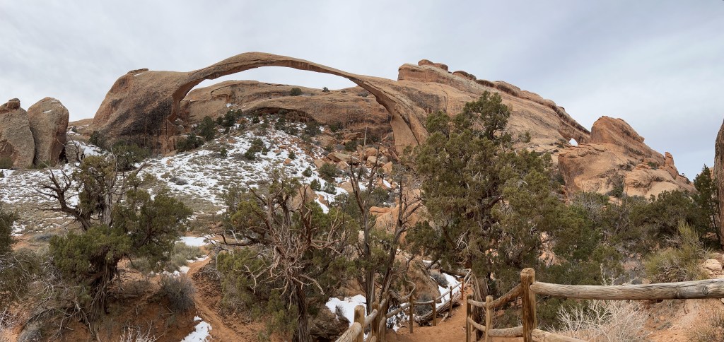
Landscape Arch above spans over 100 yards. Photographs fail to render the three dimensional features. Only by hiking up the trail, turning that last corner and wandering around to view from different angles do the arches reveal their true nature. My head was spinning trying to take in the detailed patterns on rock faces, judge the sizes of dramatically shaped features, imagine the geologic timescale and focus on the variety of terrain in every direction at different distances.
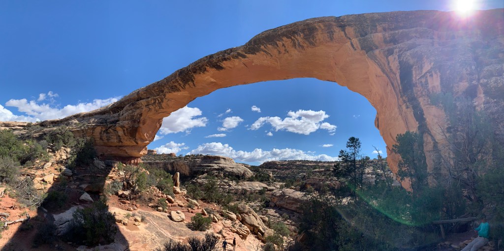
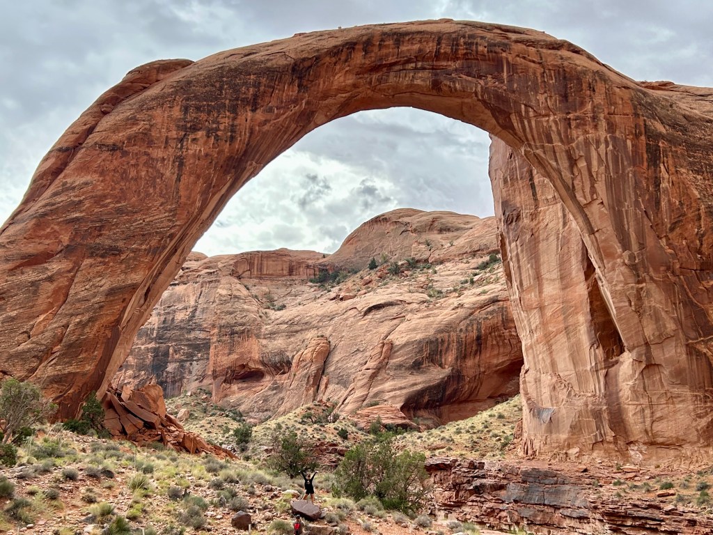
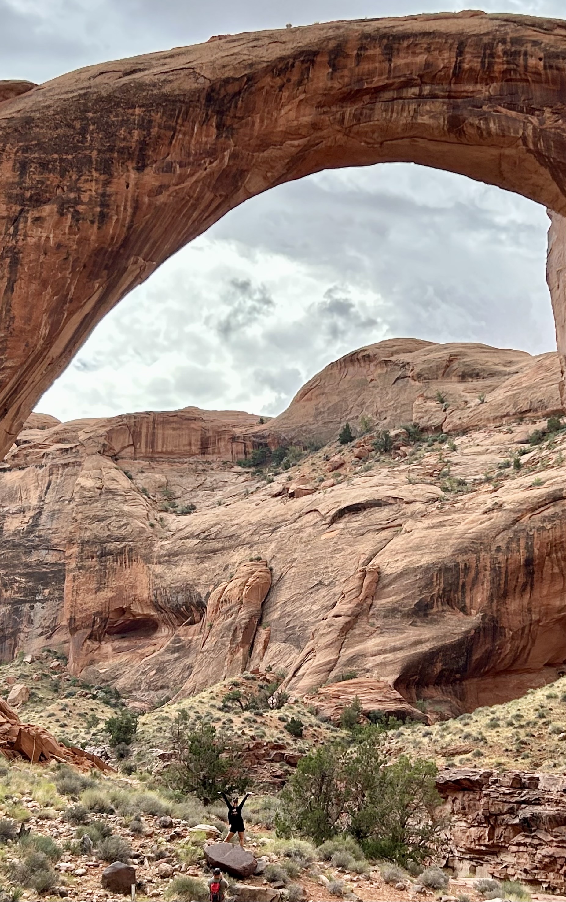
The reason there are more arches here than anywhere else in the world is salt. As elsewhere, the land formed in layered deposits, rose up and eroded. The unique part was that there were more layers of salt from shallow inland seas which slowly migrated underground and piled up against a hard fault line, forming an unstable underground salt dome that liquified and caused many long straight vertical cracks in the rock layer above. The exposed fins of sandstone eroded from both sides forming many arches and small windows. (Bridges are entirely different than arches).
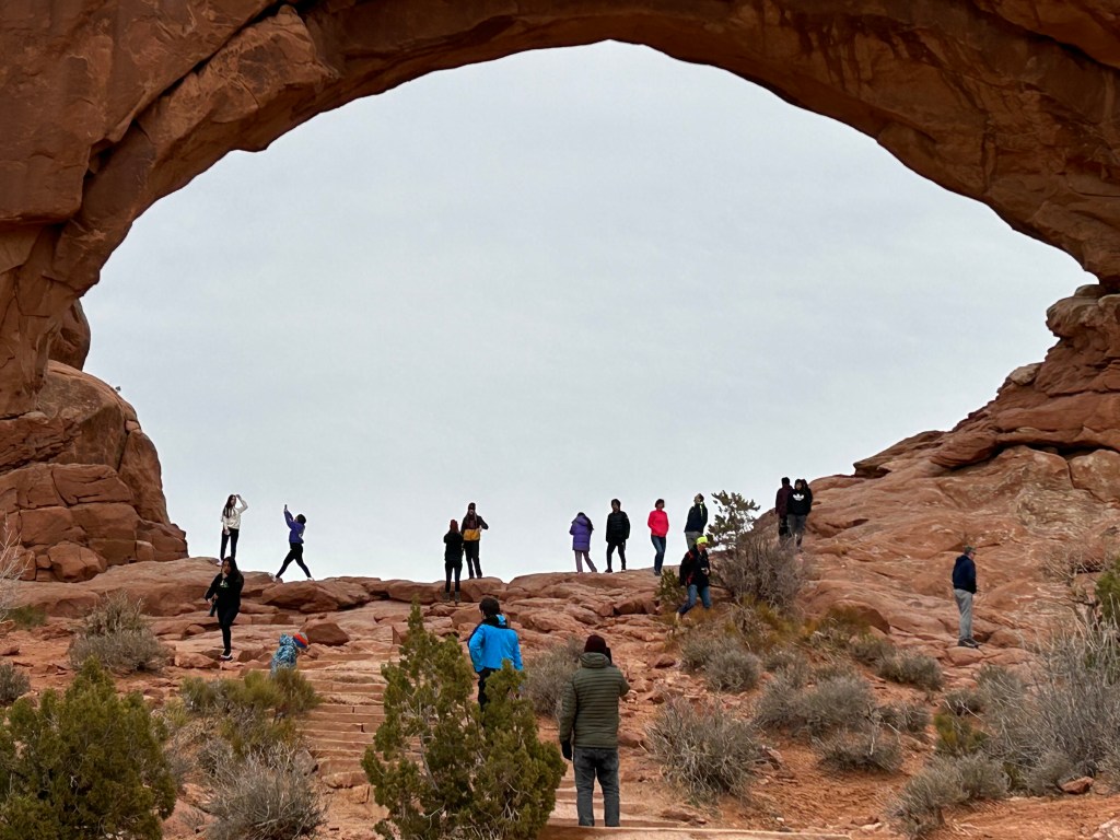
In theory, the most famous arches are easily explored. Only a few miles from Moab, the main park road climbs up through the dramatic red canyon and branches off towards Delicate Arch above a salty valley, past Balanced Rock towards the Windows and up above to the Devil’s Garden. Each area has parking, and many of the trails are easy. In March, there were only a few visitors in the morning, and every arch waited patiently for me to admire. But by April the park requires timed reservations due to crowds, and in summer the heat can become dangerous. So in practice, you should time your visit thoughtfully, especially if you want to capture sunrise or sunset views without crowds. This is one of my favorite parks for geologic features.
Like most people who travel through the crossroads of Page, I paid $10, walked 3/4 of a mile and took a picture of Horseshoe Bend. It’s an easy photo, especially around 2:30 pm, with the sun shining down over your left shoulder onto the deep oxbow canyon below. On a clear day the blue sky reflects in the river, and the height of the overlook makes a photo idiot-proof, easily framing the river bend from cliff to cliff and from horizon to bottom’s edge. Even I, a mediocre photographer at best, got the shot I dreamed about. But instead, I decided to show you the uglier view above.
“a curious ensemble of wonderful features —carved walls, royal arches, glens, alcove gulches, mounds and monuments. From which of these features shall we select a name? We decide to call it Glen Canyon.”
John Wesley Powell, explorer
When John Wesley Powell first explored this canyon in 1869, he and his crew were amazed by the varied beauty of the place. Above all the impressive geologic features, they decided the best part of the canyon were the narrow green glens, teeming with specialized flowers, birds and animals. Less than 100 years later in 1963, the beautiful glens of Glen Canyon were drowned, and in a cruel irony, the temporary bathtub was named “Lake Powell” after the explorer & geologist who most loved the living glens.
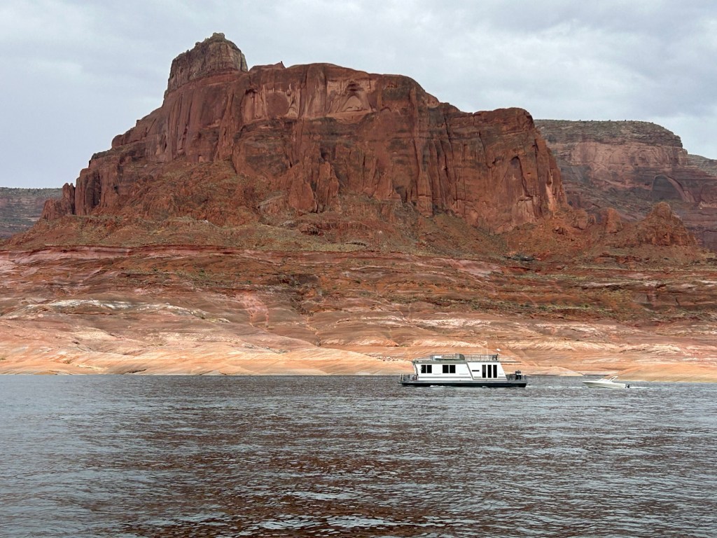
In retrospect, Glen Canyon Dam should never have been built. Lake Powell, above the dam at right, is a sad collection of marooned boats with ramps and docks that don’t reach the water, so most of the fossil-fuel burning jet skis, power boats, fishing boats and houseboats can’t keep polluting here anymore. The “lake” is more of a stagnant segment of river with bleached canyon walls and a bathtub ring. Due to low water, neither the ferry at Hall’s Crossing nor the tour boats to Rainbow Bridge run anymore. When the water drops another 30 feet—later this year?—the massive hydroelectric towers above the dam to the left won’t have any electricity to deliver.
Engineers no doubt consider the dam to be a victim of its own success, drawing too many people to Arizona with cheap electricity and “plentiful” water. Economists likely consider the dam a fiasco, since all the expensive infrastructure is practically useless now, long before returning on the investment. Common sense says that dam or not, you can’t have your river and drink it too. Environmentalists, who opposed the dam from the beginning, say “we told you so”. Climate scientists say, “it’s going to get worse”.
After all the park is desert—mostly remote canyons in Utah—, and the river isn’t big enough for people to waste. I drive past a lot of busy car washes and gas stations with patches of grass, while the shiny vehicles burn carbon and diminish the mountain snowpack. On my way southeast, I drove through Gilbert, Chandler & Ocotillo neighborhoods near Phoenix. While riff-raff like me aren’t allowed past the walls, gates and guards, satellite maps show private golf courses, lakes, and homes on private islands, all in the desert. It’s tragic to see glimpses of all that water wasted, while our national recreation areas run dry.
Having visited now in winter as well as in summer, clearly this is a drop dead gorgeous park. A California Condor circled overhead waiting to see if the views would really kill me. Perhaps that’s why so many of the natural geologic features are given heavenly names, like the Great White Throne, Angel’s Landing and the Temple of Sinawava (the Paiute Coyote God). With fresh snow on the Riverside Walk above, I felt like a kid gawking up at waterfalls until my neck hurt, and I spotted other adults who childishly made snow angels and slid down slopes. Best of all, I had sections of the park to myself, a far cry from summer crowds. This is my favorite ‘snow day’ park.
If you haven’t yet visited, go in any season and hike. Explore as many corners as you can from driving the tunnel, to walking in from the pedestrian bridge, to the Kolob Canyons, the Narrows and any of the wilderness. It’s indescribable. If you can, stay at the Zion Lodge in the park, with a good restaurant, comfortable cabins and EV charging. Despite folks complaining about EVs in cold, I was happy to have dual motors and remote defrost. My vehicle went from snow drift to clear windows, heated seat and steering wheel, while I packed up in my cabin. I wanted to avoid the mandatory shuttle, as it is not yet fully electric (soon!), and seeing Zion in winter is like visiting a different less crowded park. In summer, it’s easier to get to the higher viewpoints and see more wildlife, but winter has a desolate stark beauty even in the middle of the canyon. Next time I should try spring or fall.
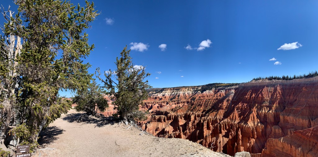
I hiked out here 2 miles round trip to Spectra Point to get a view with Bristlecone Pines, so that you can tell this is not another photo of Bryce. There are a number of Bristlecone Pines here and a few more near Chessmen Ridge Overlook, although they are likely younger than some at Great Basin. By the way, if you’re looking for cedar trees, there never were any. Early visitors from back east mistakenly thought that the juniper trees were cedars, and the misnomer stuck. Cedar Breaks is over 10,000’, so it’s a step or two above Bryce, but since it extends down through and exposes the same layer of rock, it looks similar near the top. The view down the gorge looks down over 5,000’ towards also misnamed Cedar City, so you get a good look at the various layers of the grand staircase. Be careful hiking here, as high altitude contributes to vertigo. Due to the heights and erosion, there aren’t any recommended trails down from the rim, but there are a few rim trails and seven overlooks, four of which are near parking. While the road and trails may still be open, there was frost on the trail when I visited, and the roads will close as soon as it snows. The temporary visitor center and store has now closed for the season, and the new visitor center at Point Supreme Overlook is still under construction. Hopefully it’s open next year.
This view is of Bryce Amphitheater from Bryce Point in the morning. Below are the 5.5 mile Peekaboo Loop, 1.3 mile Navajo Loop, 1.8 mile Queens Garden and other trails through the hoodoos. Definitely do at least one hike, if you’re able at this altitude, or even better, book a trail ride from the lodge. I won’t ever forget the spectacular feeling of riding through a layered maze of brightly colored hoodoos with my family; it is one of the best park experiences I have ever enjoyed.
There are around 15 different trails and as many overlooks, including Mossy Cave, Natural Bridge, Rainbow Point and Fairyland Point. Carbon burners should stay home or at least park and take the free shuttle, which goes from the hotels and campground near the entrance to the lodge and the most popular viewpoints and trailheads, but, since the shuttle is not yet electric, I drove my EV around early.
Bryce Canyon is between 7,500’ and 8,500’, and it is one of the prettiest places to appreciate geology. Long story short, the inland sea dried up, the land rose and erosion created the hoodoos and the rest of the canyons in the area. Grand Canyon is the bottom of the grand staircase, Zion in the middle and Bryce near the top. The colors of the steps span from ancient dark rock, tans, chocolate, vermillion, marble, to pink and white. And, if that’s not enough, it’s easy to see mule deer and other wildlife, wildflowers and to appreciate the dark night sky.
For millennia people had been using this spring to live, grow crops and travel through, but then the Mormons built a fort and walled it off. 80% of the Kaibab Paiute population died off between 1490 and 1860, many from starvation. The Mormons also enslaved the natives, technically 20 years of indentured servitude, after purchasing them from native slavers, a practice the natives learned from the Spanish.
On this trip I saw both the Green River at Dinosaur and the Colorado River in the Grand Canyon explored by John Wesley Powell, who employed Kaibab Paiute guides. Years later when Powell became director of the US Geologic Survey in DC, a Mormon missionary, translator and expedition member named Jacob Hamblin wrote to his old friend about how the Kaibab Paiutes were dying of starvation.
“The foothills that yielded hundreds of acres of sunflowers which produced quantities of rich seed, the grass also that grew so luxuriantly… the seed of which was gathered with little labor, and many other plants that produced food for the natives is all eat out by stock.”
Hamblin to Powell, 1880
Eventually, the US government intervened and gave the Kaibab Paiutes rights to 1/3 of the water, along with 1/3 to the perpetrators who were using the fort as a hideout for ‘plural families’, and 1/3 to the federal government. Like many wrongdoers, the Mormons at the time tried to justify their killing of the natives by saying that some natives had killed two Mormons, that they were bringing civilization to the natives and that they were more productive. I wasn’t interested in the Mormon pioneer fort or the old self-serving justifications, but the historic conflict over marriage rights seemed ironic, given the 2008 Mormon campaign against gay marriage in California. In any case, the native history is fascinating and helps explain why Utah is 1% Native American and over 2/3 Mormon. There’s a garden run by the local tribe that grows the three sisters (corn, beans & squash) along with Amaranth, which was a beautiful deep purple.
Overall, Utah does an exceptionally good job in managing its remarkable natural resources, but the climate crisis allows no time for delays. Today the spring above is full of toxic algal mats that can release deadly Cyanobacteria neurotoxins, which appears to be spreading as the climate warms. Civilization is destroying life on earth, via carbon pollution, so it hardly deserves the name.