South Park City, an old western summertime tourist trap in Fairplay Colorado, is only an hour and a half drive southwest from Denver, and yes, the cartoon is based on this tiny town surrounded by mountains. The mining and ranching town is at ~10,000 feet, and there’s an old railway roundhouse nearby. Some of the ranches organize riding tours, and there are plenty of scenic mountains, canyons, creeks and old mining sites to explore. The trout fishing is renowned. The South Park National Heritage Area is building a good track record of saving old buildings, protecting natural areas and boosting tourism.
About an hour drive north of Denver in Fort Collins is the Cache la Poudre River (French for Gunpowder Stash). Below is the Poudre River Whitewater Park, perhaps the best example of a how planning can turn an urban river into a recreational star. Due to a long-term cooperative water district that balances various stakeholder interests, the river is surprisingly well managed. The wild and scenic section up in the mountains preserves nature, protects wildlife and is enjoyed by whitewater rafters and kayakers. But I saw a kayaker preparing to raft the short stretch of whitewater in town, after changing out of work clothes. The Cache la Poudre River National Heritage Area also includes museums, historic sites and open natural areas in and around Fort Collins.
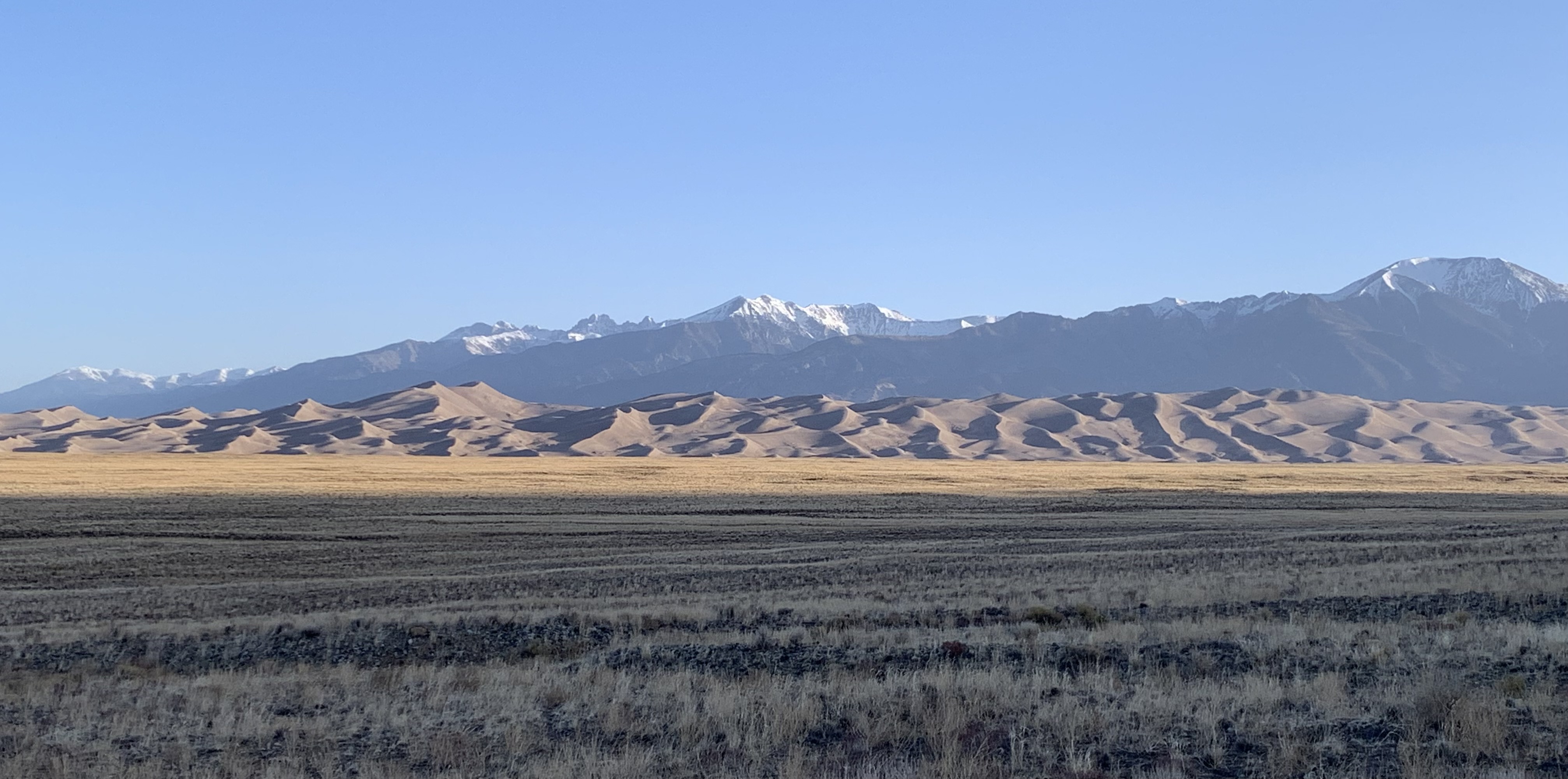
Quick logistical update: until summer, Mondays are Mexican World Heritage Sites, Thursdays are eclectic, and Saturdays are bonus park photos. I took the photos above yesterday in New Mexico and Colorado.
While technically in different regions, both National Heritage Areas are linked by the river, the mountains and our cultural heritage. The Rio Grande begins in the San Juan Mountains in south central Colorado and flows east through the San Luis Valley where it turns south into New Mexico. The scenic north section is called the Río Grande del Norte to distinguish it from the southern section that defines the Texas-Mexico border. The river flows through the Rio Grande Gorge and is now popular for whitewater rafting (see three rafts above left). In the distance are the Sangre de Cristo Mountains (both photos).
Native Americans and Spanish explorers traveled up and down the river, settling on the fertile valleys. The native land was claimed by the Spanish, Mexicans, and Texans, and for a dozen years, the Río Grande del Norte defined the US-Mexico border in Colorado, before the US claimed the land all the way to California by treaty in 1848. In the Civil War, Texas secessionists battled Colorado volunteers at Glorietta Pass in New Mexico to decide the war in the southwest.
The Northern Río Grande National Heritage Area in New Mexico celebrates this magnificent natural scenery and the cultural heritage it guided. It also includes Taos Pueblo, wild & scenic rivers, historic trails, scenic byways, and several cliff dwellings. Much of the land is also a BLM managed National Monument. The area is both beautiful and fascinating, and I was not going to miss another chance to drive through on my way northeast.
The Sangre de Cristo Mountains tower over the east side of the Río Grande del Norte from east of Santa Fe NM up into Colorado past the Great Sand Dunes. Meaning ‘blood of Christ’ in Spanish, the name likely refers to the scarlet colors of the mountains at sunset. The helpful illustration (my favorite photo above right) is on the Stations of the Cross trail up to a church that overlooks the historic San Luis Valley.
The Sangre de Cristo National Heritage Area in New Mexico borders the Northern Rio Grande National Heritage Area in Colorado, and includes the Cumbres and Toltec Scenic Railroad featured in Indiana Jones and the Last Crusade, the Monte Vista National Wildlife Refuge famed for Sandhill Cranes in March, and Fort Garland, a fine restored Kit Carson fort with an interesting museum on Buffalo Soldiers—one turned out to have been a woman who served for years as a man undetected. The area is lovely and pastoral amid snow-capped mountains, with many other worthy attractions, but I’m on the road again.
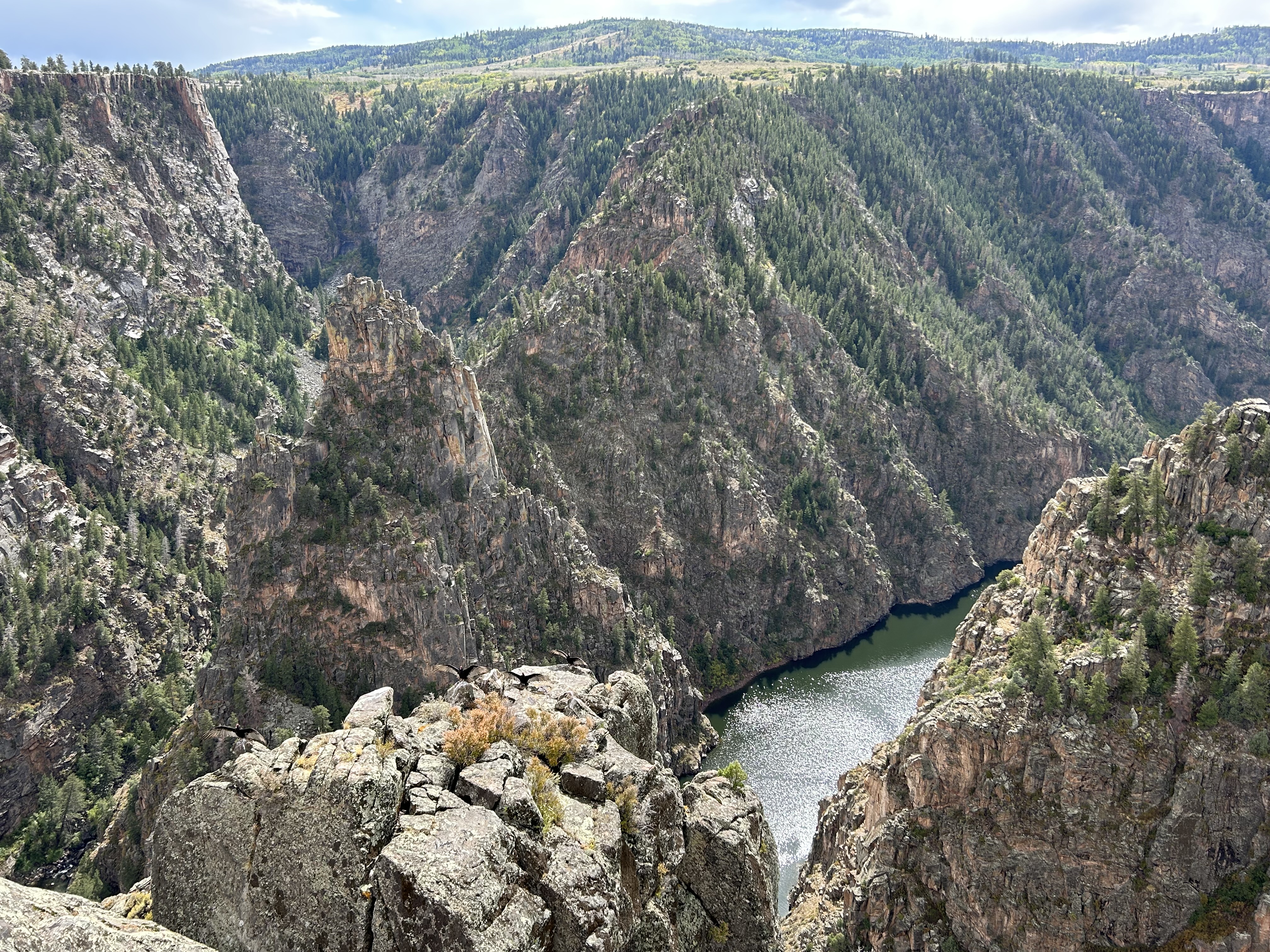
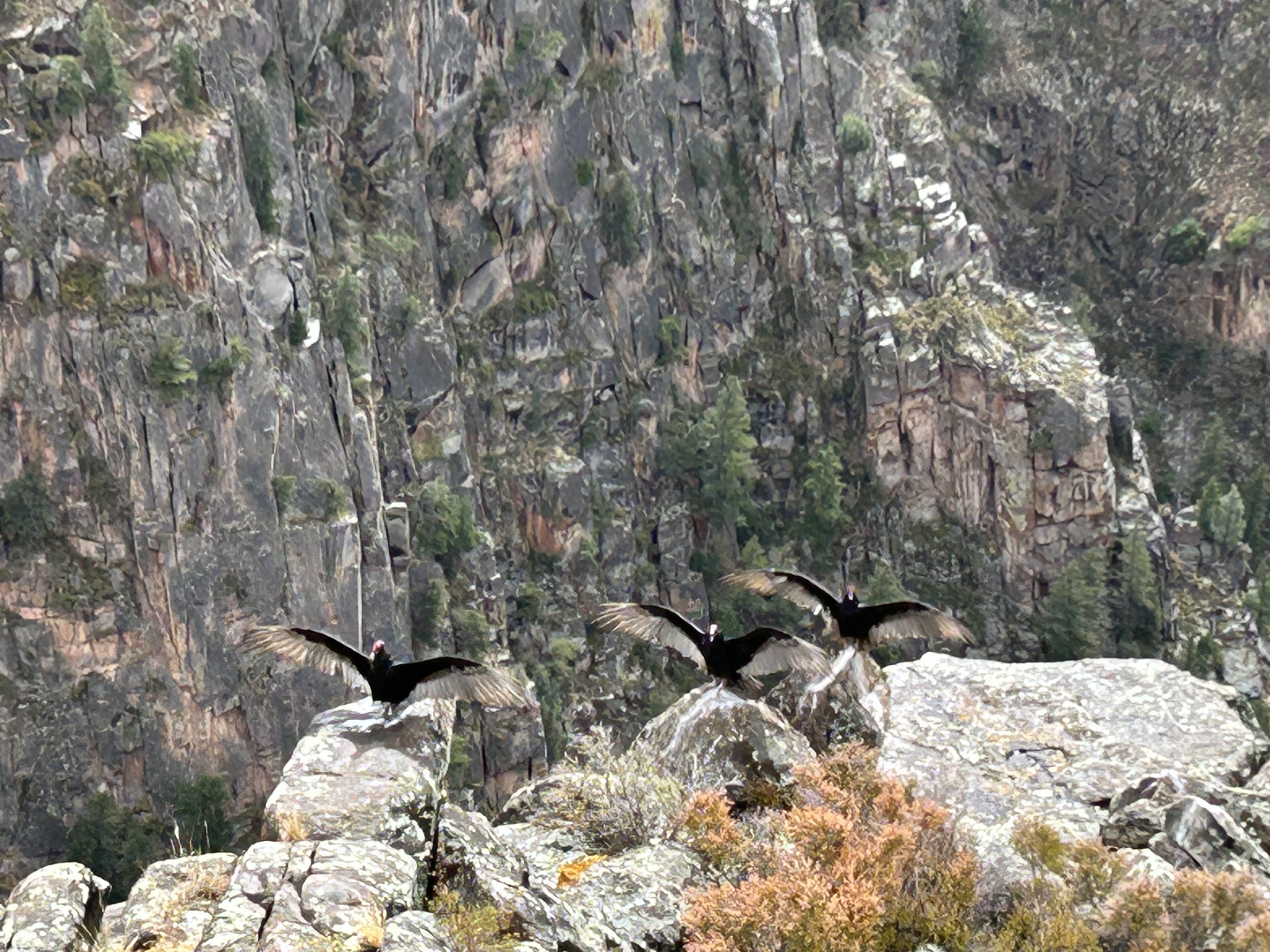
The 700’ granite spire above that rises out of the Gunnison River at the confluence of Blue & Curecanti Creeks is the Curecanti Needle, formed by an earthquake fault running straight across the canyon. The half dozen turkey vultures in the foreground below it are drying out after a brief rain shower.
There are much more difficult ways to get here than driving to Pioneer Point Overlook, including climbing down hundreds of steps with gear and paddling down the river (and then back up), but I took the easy way. If someone is nice enough to build an overlook, then it’s best not to waste it.
Upriver from the Black Canyon, there are several dams and large basins with powerboats, and a very small, but pretty hike through the Cottonwoods along the riverside Neversink trail before the town of Gunnison. I skipped the artificial reservoirs and didn’t see any wildlife on the hike, but driving through colorful Colorado in early fall is always a pleasure.
Have you ever wished that someone would build a road up along the canyon rim with cool tunnels and overlooks, so you could see the features up close and hike out on the points? Well, then this is the park for you! A man named John Otto began building that road over 100 years ago, including his trail out to view the point above.
The winding, tunneled scenic canyon rim road now has bicyclists and antique cannonball rally motorcycles. Besides the enviable promontory pictured, there are several 500’ deep steep canyons to explore along Rim Rock Drive: Ute, Red, Monument and more. Watch out for Bighorn Sheep—I saw one—and raptors—second time this week that one whooshed past my head as I stood on a cliff. I saw a flash of bright yellow, so I think this was a peregrine falcon. Watch your step along the cliff edge!
The Gunnison River runs from the Black Canyon past the monument and the scenic Dominguez-Escalante and McInnis Canyons conservation areas, making for a scenic drive.
The rangers I asked discouraged me from visiting, because the reconstructed wall above and small mounds are all there is to see. But what makes this place special is that it is in the middle of the rich agricultural valley below Mesa Verde, and it wasn’t completely destroyed, vandalized or eroded away. Large pueblos, like this one with hundreds of rooms, used to be scattered across the region, but, as at Hopewell, the ones located in rich farming areas were often plowed under. This is actually one of the largest archaeological sites in southwest Colorado, recognized by researchers in the 1870’s, protected as a monument in 1919 (and by a bequest from the landowner at the request of an archaeologist) and protected unofficially by another landowner who donated an access route in 2002. Also unlike other sites, the archaeologists have mainly used less-invasive techniques in their research, saving the site for future generations.
This is Balcony House, which requires a reserved ticket, climbing cliff-side ladders and crawling though a short tunnel. It’s worth it. The dwelling is named for the intact, original balcony on the right side of the photo under two upper story windows. At other cliff dwellings across the southwest, typically only the beams remain, like those on the wall to the far left. This dwelling is also unusual for facing northeast, lacking fires in this section, and for the large flat floor with a low wall at the edge of the cliff. This place was used for important gatherings, but not in winter.
Mesa Verde is a huge, green high plateau, so start at Park Point Overlook, where you can see from Colorado’s snow-capped peaks to Shiprock, which I first saw after visiting Canyon de Chelly. From up here, you get a sense of the region as one greater community of interrelated tribes, trading and interacting with one another frequently, and not four separate arbitrarily bounded states.
This is my favorite park for cliff dwellings, so see as many as you can. The Cliff Palace is the largest in North America (reserve a ticket), and while you only walk along the bottom edge, you do get close enough to appreciate its extent and architecture. Spruce Tree House is only visible from an overlook, Long House was booked, and Step House was perfect to visit on my own first thing in the morning. The ranger talks are extremely informative, even after visiting many other Native American sites.
Finally, slow down here. The mesa has basically no Wi-Fi or cell signal (save a photo of your tickets). There are bus loads of tourists, so the few places to eat are crowded (Metate needs reservations). The Far View Lodge rooms don’t have TV, and it can be a peaceful place, if you try. My laptop finally stopped working, so I ended up sitting outside, saw a rabbit and thought long enough to reconsider my past and future. This World Heritage Site has already seen more recent devastating wildfires than they have cliff dwelling sites open to visit, so these moments in places like this are rare and diminishing rapidly.
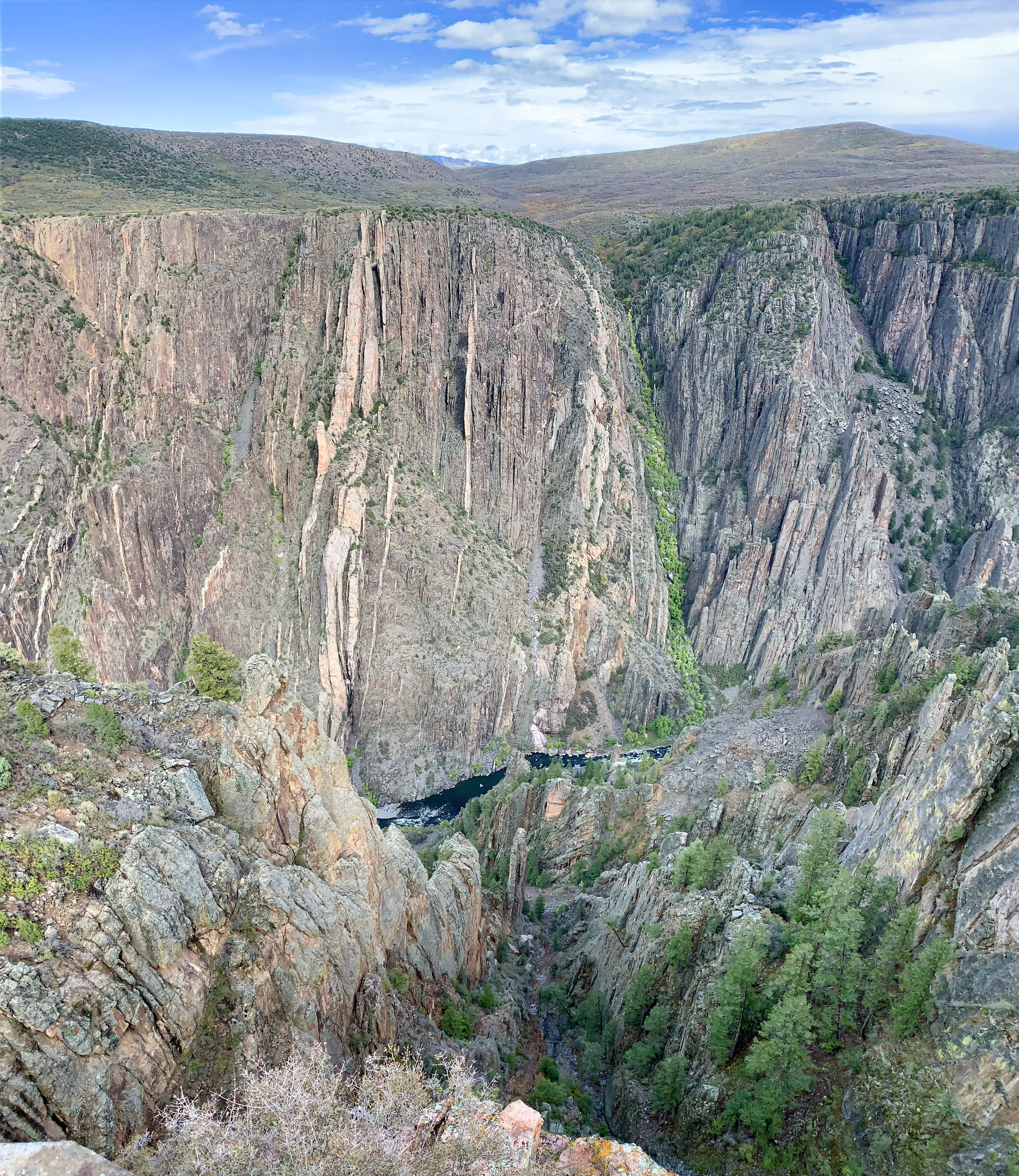
This view is looking downstream from Sunset View overlook, but the upstream view is blacker, steeper and narrower. The canyon there is over twice as deep (2250’) as it is wide at the top. The Sawatch Range, Elk Mountains and San Juan Mountains all feed into the canyon in spring. There are half a dozen good overlooks on the South Rim to peer down into the canyon, and some cause vertigo, as the cliffs are near vertical drops from the rim. The North Rim is a 2 hour remote drive, has fewer overlooks, a campground and horseback riding.
The South Rim has a campground and a visitor center, and is only steps from Gunnison Point, which may have the best view down into the canyon, although my photography skills were insufficient. The short hiking trails along the rim, down into the canyon (a little) and to the high point to the left above each provide a different view into the geologic depths.
The East Portal campground is technically in Curecanti NRA and is accessed by a steep road down to the Gunnison River (barely visible above) near the upstream dam. I’ll have to come back. Since I arrived here in October, there was already snow falling in the mountain pass on 50 to the east. The road was also being repaired after some fearsome rockslides. On the plus side, the drive through the mountains included bright fall foliage that contrasted with the black rocks. Montrose makes a convenient spot to charge, and it has two well-reviewed Himalayan restaurants.
North northeast of the park, the river flows through Gunnison Gorge, a large wilderness and conservation area. So the park’s unwieldy name distinguishes the Black Canyon area from the less visited Gunnison Gorge area, though it’s all one contiguous rough landscape carved through by the Gunnison River.
President Biden authorized this new park in March, but it will take time to become fully established. The local community is important in determining whether a park is created, how it will happen and when. In this case, the local Granada High School has been working on preserving the history here for many years and is largely responsible for the reconstruction of the guard tower above.
As with Manzanar and Minidoka, the image of a guard tower evokes the reality of the imprisonment of Japanese-American citizens during WWII. Each of the towers surrounding Amache was manned with a machine gun and a spotlight. But inside the camps, it is often the Japanese cultural touches that strike me, the rock gardens in Manzanar and the silk screen shop here. The silk screen shop was so good, that the incarcerated citizens made posters for the US Navy. Despite their incarceration and wrongful denial of their Constitutional rights, these citizens were proud of their country and many of the children joined the Boy Scouts and Girl Scouts here.
There are various monuments and markers remembering the 31 killed in action fighting for our country in Europe while their relatives were imprisoned, for the over 1,000 US military veterans from this camp including many interpreters, and for the over 100 inmates who died here, some before their time. While many were later reinterred elsewhere, a few graves remain in a Japanese styled cemetery, along with a memorial stone and a photo of the original epitaph, written in Japanese.
Interestingly, Colorado citizens of Japanese ancestry were not incarcerated, because the governor, Ralph Carr, correctly believed the program to be unconstitutional, arguing that once a majority violates the rights of a minority, “then you as a minority may be subjected to the same ill-will of the majority tomorrow.” His principles likely cost him his next election. (If the nearby town of Chivington wants to replace its shameful name, they could rename their town Carr).
But the Japanese [Americans] are protected by the same Constitution that protects us. An American citizen of Japanese descent has the same rights as any other citizen. … If you harm them, you must first harm me. I was brought up in small towns where I knew the shame and dishonor of race hatred. I grew to despise it, because it threatened the happiness of you and you and you.
Colorado Governor Ralph Carr to a hostile audience in 1942
Giant Redwood trees once lived here, in Colorado, and many of their colorful stumps were preserved by volcanic ash along the easy 1 mile Petrified Forest Loop (at 8,400’). Early visitors took pieces of the petrified stumps and even left saw blades in the Big Stump above. See an array of Eocene fossils in the visitor center, including plants, bugs, fish and animals, and a rhinoceros bone. The volcanic ash layer captured a snapshot of the lake, meadow and forest here, which helps us understand how various plants and creatures evolved and adapted to a changing climate. But make no mistake, the current man-made climate crisis does not provide time for evolution or normal adaptation. Suddenly, our planet has a new, unprecedented and deadly climate, and most life won’t survive, unless we fix it now.
I wondered how large the peak range of the redwood trees must have been to have survived until today. They must have been successful in many different areas, like here, where the climate eventually become inhospitable to them. Now they only remain naturally in California and Oregon. People don’t seem to appreciate that for plants to survive over the long term, they need more than a few small, isolated reserves. They need to thrive in many different locations to have a chance of finding a stable and suitable one where they will have a future. Human limits, including pollution caused climate change, will extinguish species and ecosystems until we prioritize the protection of living things. Otherwise, all that will remain will be fossils and images of once thriving species.