At 36, Jacques Marquette was already a famous explorer and missionary. He spoke at least half a dozen Native American dialects and languages, had helped found Sault (‘Soo’) Ste. Marie, and he helped others settle and avoid conflicts. But then he embarked on a trip through Green Bay, down the Mississippi, to the Arkansas and back up the Illinois, greatly enhancing settlers’ understanding of central North America. The return route, suggested by native guides, proved the pivotal Chicago Portage. Beyond his importance to French Catholics and their descendants, he introduced Christianity to many Native American tribes, and his explorations and settlements helped determine the future of trade and growth in the Great Lakes, on both sides of the border.
Missionaries also brought deadly diseases into the lives of many people with no natural immunity, and their practices of baptizing babies, distributing bread at Communion, and gathering closely together weekly for songs and prayers were lethal for many native communities. But Marquette traveled among the tribes a few years before Leeuwenhoek discovered bacteria. Marquette himself died after contracting dysentery at 37, and his memorial is on the north side of the above Mackinac Bridge—which connects upper and lower Michigan—in the touristy town of St. Ignace which Marquette founded. There’s honestly not much to see in this affiliated park site (since the small museum burned down years ago) except for a few plaques and a short trail, but nearby there’s a nice view of the Mackinac Bridge (above) over the straights that Marquette explored and traveled through often.
Way back in 1673, French explorers Louis Jolliet and Father Jacques Marquette were preparing to travel east to return to Canada after exploring the Mississippi River. Though the statue wrongly implies that Marquette pointed out the route, their Native American guides showed them a shortcut, by traveling up the Illinois River and portaging (carrying) their canoes between some muddy lakes to Lake Michigan. Marquette realized that if there were a canal, weeks-long journeys would reduce to days. 175 years later, the government finally built the canal, and suddenly, Chicago became one of the largest and most important transportation hubs and cities in the US.
The site itself is in a small woods between the Des Plaines and Chicago Rivers, and as part of Chicago’s river greenways, it’s managed by Cook County in affiliation with the NPS. The canal itself is 100 miles long with a bike trail, and there is a 1 mile canal boat tour in LaSalle at the Illinois River end. A non-profit association runs summer boat tour as well as the larger Illinois and Michigan Canal National Heritage Area, which includes Chicago Portage, the Pullman National Historical Park and promotes tourism to neighboring communities and parks. The canal is a key part of the Great Loop, a boat trip around the eastern part of the country, from the Great Lakes down the Mississippi, around Florida, up the eastern seaboard to New York, and back to the Great Lakes.
Captain James Lawrence was shot by the crew of a British ship blockading Boston in June of 1813. Dying, his last command was “don’t give up the ship”, but his ship was captured. Three months later, his friend Commodore Oliver Hazard Perry commanded the USS Lawrence under the flag “DONT GIVE UP THE SHIP” against the British for control of Lake Erie and access to the western Great Lakes. Despite balky support from the USS Niagara, Perry sailed up close under long range fire to bring his short range big guns to bear. The Lawrence suffered 80% casualties, was disabled, and Perry withdrew, taking command of the Niagara. He returned to the middle of the battle, pummeled the British ships and won the day. His fleet then ferried US troops across Lake Erie, where they forced a British retreat. US negotiators leaned heavily on these victories when negotiating peace, making Perry’s victory here perhaps the most consequential of the War of 1812 and for determining the US border with Canada today.
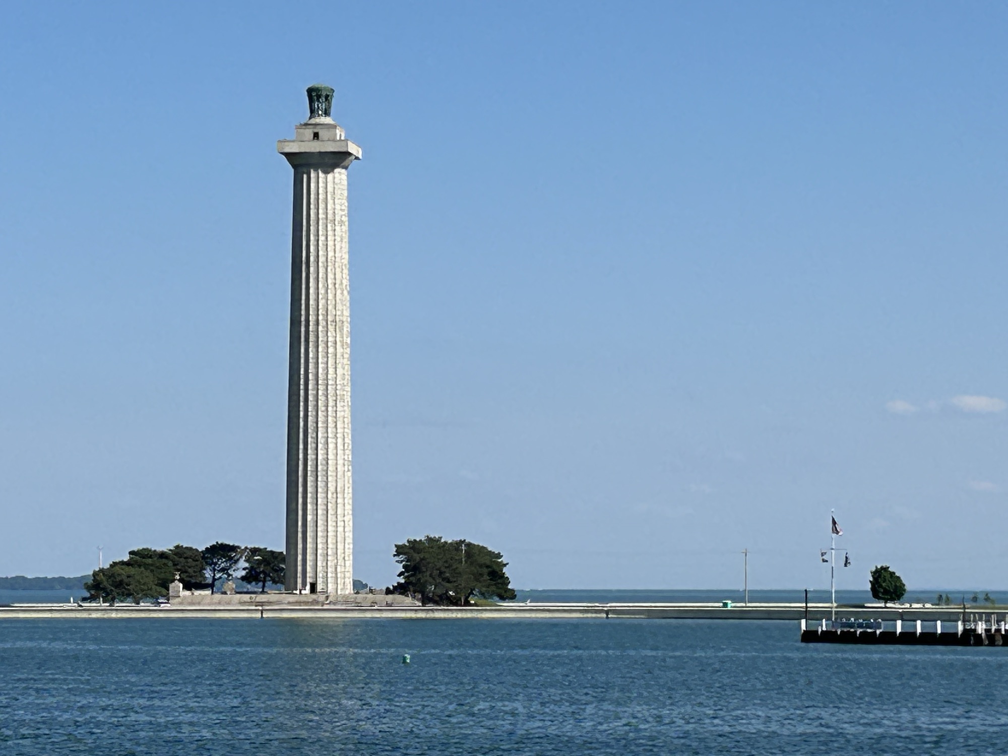
One of Perry’s younger brothers, Matthew, commanded the ‘Black Ships’ that sailed into Tokyo Bay and forced the internationally isolated Japanese Shogunate to open its country to the West in 1854. There are several ferry options for visiting the touristy island town of Put-In-Bay, and Perry’s monumental tower—the world’s largest Doric column—has great views of the surrounding islands, part of the longest undefended international border in the world, and the naval battlefield. Three British and three US officers are interred in the memorial, and the regular sailors killed were sewn up in their hammocks and committed to Lake Erie. Please take some time this Memorial Day weekend to remember those who gave their lives for our country.
[At the bottom of the web post, there’s a short video surprise! No peeking until after the story!]
Once upon a time, not far from the Black Forest in Germany, where many old fairy tales began, there were two friends, Johann and Eberhart, who believed that being inspired by God should be a personal experience. They shared their views with others, and many joined them, meeting under an old castle, happily. But other people were angry with them for being different, so some of their followers got on a boat and traveled to a new country, where people were free to believe whatever they wanted. The first place they settled grew too crowded and busy for them, so they moved again, to a magical land between two great rivers, where their friends and families settled in seven tiny villages in the middle, along the much smaller, but pretty little Iowa River.
Their way of speaking (High German) was difficult for others to understand, so they decided to call their first village Amana, since it was easy to say. The law made them buy a village called Homestead (near the train), but they decided to call their other villages High Amana, Middle Amana, South Amana, West Amana and East Amana. They really liked the name Amana, and others just called all their villages the Amana Colonies.
The Amana colonists worked hard, but kept to themselves. Like the other farms in Iowa, they kept some of the food they grew in Silos, that look like giant tin cans. Everyone in the villages worked together, cooked together, ate together and prayed together, happily. They learned to speak the language of their new country, but they also kept up with their old language. After many years, they spoke three languages: new, old and a mix of both that they invented themselves. They didn’t have much need for money, since mostly they stayed in their own village. But curious people would visit them to buy the interesting things they made, like eggs dyed dark brown with golden flowers on them (see picture).
Then, there was a dark time in the new country, when 1/4 of the people could not find work, and the President, who grew up in a Quaker village nearby, lost his job too. The village was worried that no more curious visitors were coming to buy their golden flower eggs, so they decided that some people should go out into the outside world and work for money. Unlike their friends the Amish, the Amana community believed in technology. One, named George, was very smart and invented a machine to keep food cold for a long time, so the village added a factory next to the river with Smokestacks to build his machines. Later his company made many other machines you may have in your home, like a magic machine for cooking food very quickly. George’s Amana household appliances became known around the world.
The people in the village were very happy. If they wanted to go outside the villages, they could go anywhere. But many villagers loved Amana and chose to stay. Every Sunday at 8:30 am, they have a church service in their old language, and at 10 am in the new language. They enjoyed preserving their old way of life and kept many of their old buildings just like they were over a hundred years ago. You can still go into the old general store in High Amana and even buy a dark brown egg with beautiful golden flowers. But the villagers also built some newer stores for all the curious people who came back to see their pretty little villages, like a toy store, an ice cream store, a chocolate store, and a store that only sells old-fashioned Christmas ornaments. They have restaurants too that cook food and special drinks just like they had in the old country.
And, on the first weekend in May, the ladies of the village dress up in their fanciest dresses, that their mothers and grandmothers saved and taught them how to make, put flowers in their hair, sing in their old language, and dance in the middle of the Main Street, pulling on long colorful ribbons tied to the top of a pole, just like their ancestors did in the old country many, many years ago to celebrate Spring. And do you know what? This whole story is actually and completely true, and not a fairy tale at all! The End.
Maifest 2024, “Mai the Fest be with you”, on Main Street in Amana, Iowa.
[And, no, I haven’t had a stroke, yet. If you think you’re too old for my favorite fairy tale post, then find a kid, and read it to them.]
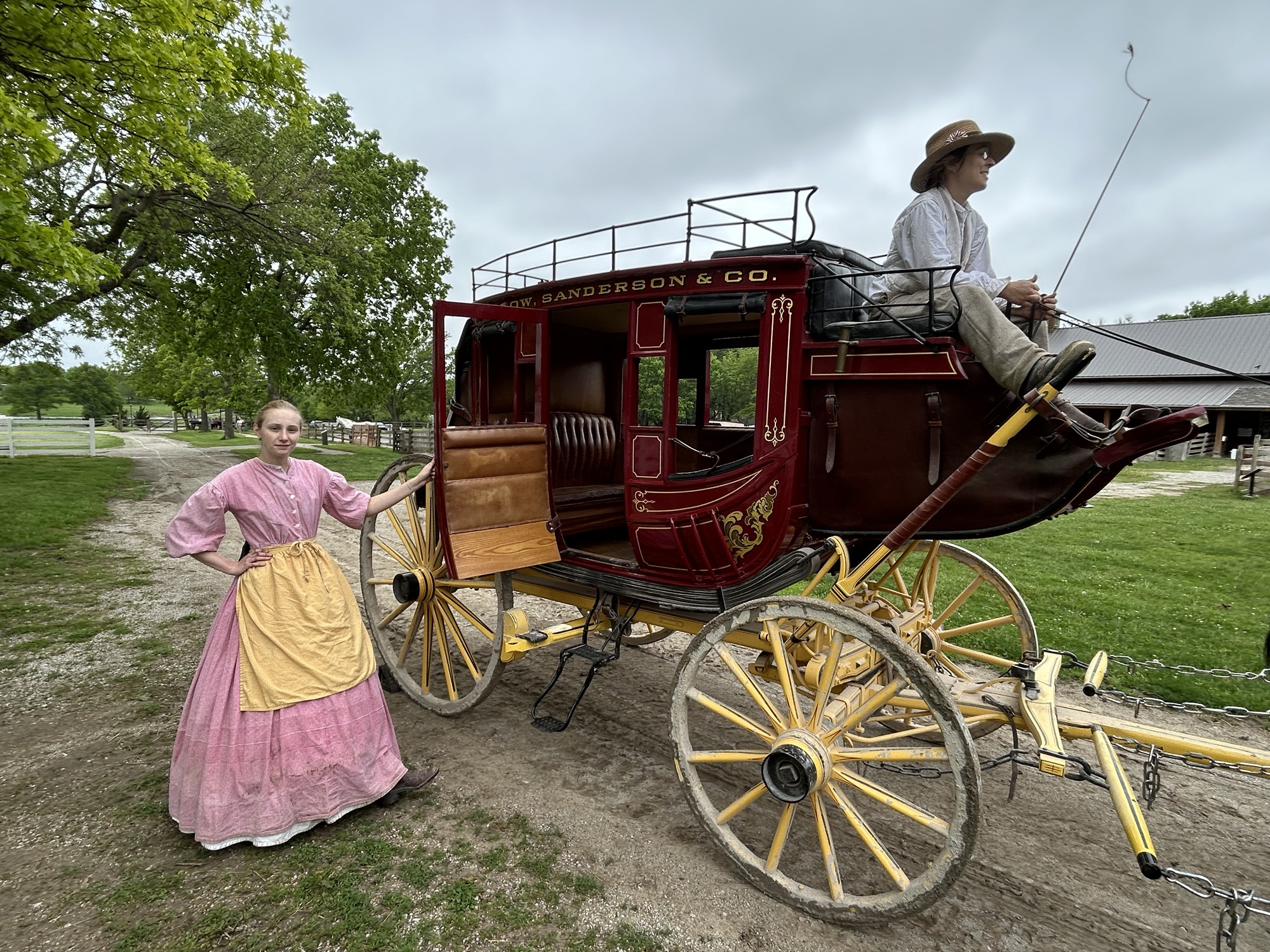
Kansas does not deserve the short shrift it often gets. At the state-managed Mahaffie Stagecoach Stop and Farm, for $7 I rode in the Santa Fe Trail stagecoach above, ate a quick bite as the passengers did in the original house, dodged heritage chickens in the yard, saw a ‘prairie schooner’ in the barn, carefully watched a blacksmith demonstration, and learned how differently vintage baseball was played in 1860. Living history is so much better than a regular museum, although they have one of those here too. The staff is bright and answered all my dumb questions quickly and cheerfully. This is my favorite trail stop.
Turns out that John Brown’s half sister lived here and insisted on strident ‘free state’ politics, doubtless supporting the Underground Railroad. John Brown freed slaves from Missouri, and one of his sons was killed fighting ‘border ruffians’ in front of his half-sister’s cabin nearby. Bushwhackers from Missouri frequently crossed the river to try to rig the election in favor of slavery, but they were fought by local Jayhawkers. Around 100 people were killed in the violent fighting known as Bleeding Kansas that is considered a prelude to the Civil War. Kansans’ staunch and courageous support for freedom was the hope of the nation, at a dark time in our history.
The greater area is also the starting point for basically all the trails going west, including Lewis & Clark, the Pioneer Trails and the Pony Express, all of which have museums nearby. And the first documented Civil War combat by African American Union soldiers—the 1st Kansas Colored Volunteers—occurred at Island Mound (YouTube) in Missouri, although not the first regiment. Oh, and Amelia Earhart’s birthplace, the Negro Baseball League and other interesting sites are also part of the NHA, along with official NPS sites like Fort Scott, Fort Larned and Brown v Board. So, let’s give Kansas some overdue credit.
The animosity against African Americans, especially in the Deep South, is hard to comprehend, but it is deep, real, persistent and extremely dangerous. Emmett Till’s mother warned him, but even she underestimated the risk. In late August of 1955, Emmett Till was kidnapped from his great uncle’s home by a shopkeeper’s husband and his half-brother, who accused Emmett of whistling at the shopkeeper, a white woman. From past midnight to pre-dawn, the two men, along with several others, held Emmett, aged 14, in the back of a pickup truck, drove around the county, terrorized him, tortured him, shot him and dumped his body in the river. Witnesses reported hearing Emmett’s screams all over town for hours. His great uncle reported the kidnapping, the men were arrested, and the body was found a few days later. His mother, saying “let the world see what I see”, insisted on an open casket at the funeral in Chicago. Jet magazine published photos of his brutalized body. His mother became a lifetime activist, author and motivational speaker on education, poverty and Civil Rights with the NAACP. Many consider Emmett Till’s killing to be the beginning of the Civil Rights Movement, not least because Rosa Parks cited Emmett as the reason she kept her seat on the bus in Montgomery on 1 December 1955.
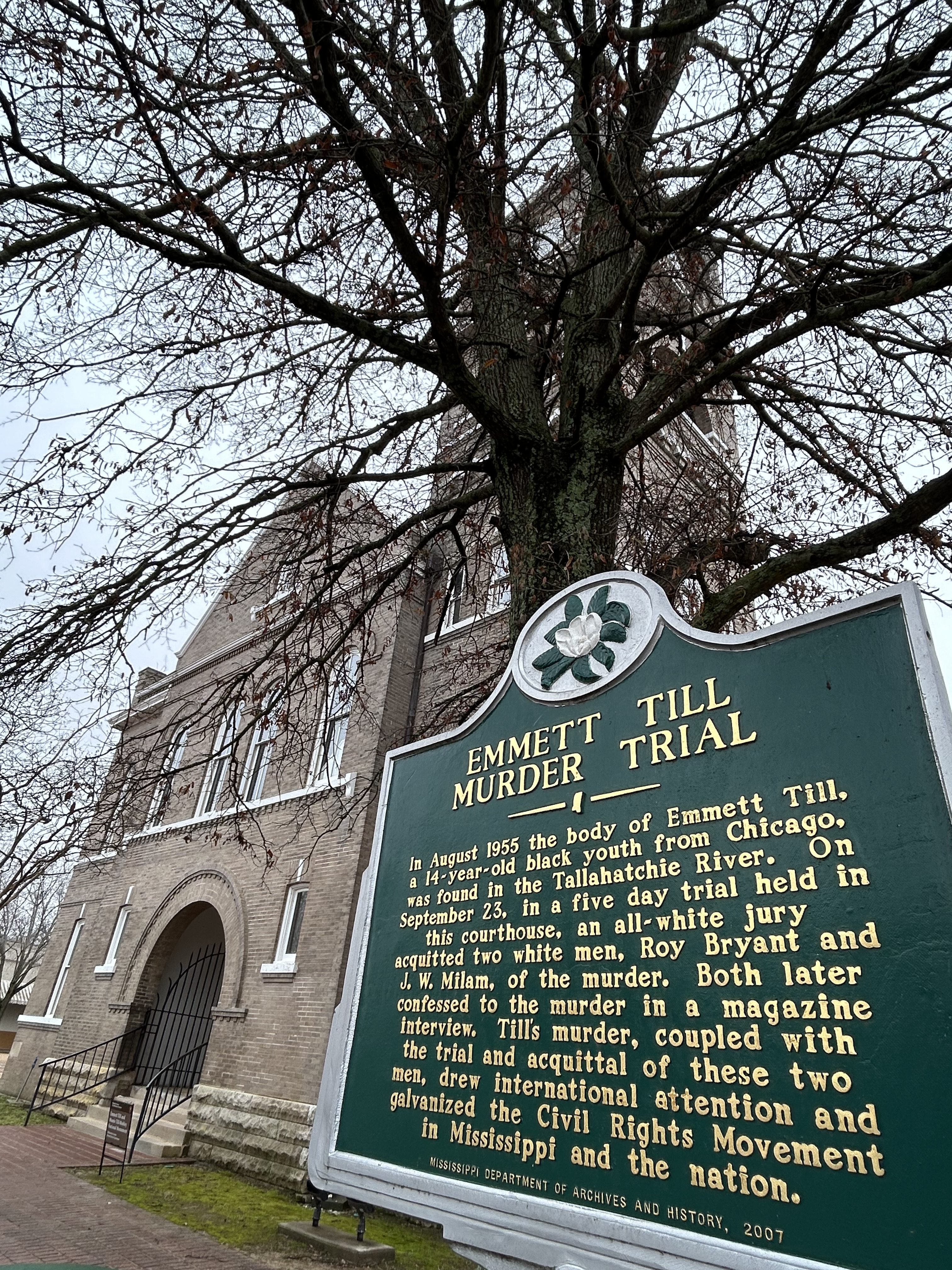
The trial was a foregone conclusion. Outside the courthouse (below) stood a statue dedicated to the “Heroes” of the Confederacy. Inside there was no justice. Instead of jurors, police, court officers and elected officials defending the Law, the courthouse became the focal point of a deep criminal conspiracy, based on racism. Witnesses were intimidated, hidden, immunized and silenced. Emmett’s great uncle testified at the trial, pointing out the kidnappers and murderers, and then he left town immediately and went into hiding under a false name. And for many years afterwards, there has been a concerted effort to conceal the truth. Evidence lost. Signs have been repeatedly shot and torn down. Historic artifacts and structures intentionally left to ruin or demolished. One witness, in hiding for decades under another name, still received death threats demanding silence. The confederate statue still stands in front of the courthouse, just left of the photo.
But despite the legacy of lies, terror and violence, people still work to tell the truth about Emmett Till. Especially if you’re exploring the new monument’s sites in Illinois and Mississippi, I recommend reading the darkly fascinating stories in the Emmett Till Memory Project app, after being introduced to it by one of the contributors at the Emmett Till Interpretive Center across from the courthouse in Sumner, MS. Emmett Till’s coffin is on display at the National Museum of African American History and Culture in Washington DC. His name was given to the Anti-Lynching Act of 2022. And this new national monument was established by President Biden on 25 July 2023, on what would have been Emmett Till’s 82nd birthday.
Reports of a two ton boulder of pure copper lying in a river bank on the Keweenaw peninsula of the upper peninsula of Michigan were dismissed as tall tales, until proven by a geologist in 1840. The boulder wound up at the Smithsonian Natural History Museum, a huge mining boom rush erupted, and the closest port town was named after the geologist, Houghton. Most of the small mines failed, but eventually a large consolidated firm found and mined the largest pure copper lode in the world.
Technically the copper was “rediscovered” (or stolen) as the Native Americans here had been mining it for at least 7,000 years and traded it as far as Effigy Mounds, Hopewell, and other prehistoric sites around the country—so don’t accept the common misconception that Europeans introduced metal work to this continent. However, European immigrants did expand the mines here to an astounding scale. The deepest part of the Quincy Mine above is over 9,000 feet below ground, which is over 6 times deeper than the Empire State Building is high, with huge rooms left behind after the copper seam was excavated (see photo), and 92 levels mostly flooded after the mine closed in 1945 due to competition from western mines.
The huge equipment includes many rare and once record-breaking pieces of industrial machinery, and the Quincy Mine tour is fascinating and essential to understand miners’ lives. Be sure to get a big Cornish Pasty at Roys in Houghton. There are some museums and a visitor center in Calumet, including a magnificent old theater with lovely murals, but since most of those tours are only in the afternoon, it may be smarter to tour the mine in the morning. There are a couple dozen interesting sites on the Keweenaw peninsula, but for me the most haunting exhibit was the description of the Italian Hall disaster at Christmas in 1913.
While capitalists are allowed to organize freely under the law, labor was not. Thousands of copper miners went on strike, and the mine owners hired ruthless, violent strikebreakers. Someone—an anti-unionist according to eight witness who later testified to Congress—yelled ‘fire’ into a crowded Christmas party on the second floor of the Italian Hall in Calumet. There was no fire, but 59 children and 14 adults died. Woody Guthrie explained what happened below.
“The copper boss’ thugs stuck their heads in the door, One of them yelled and he screamed, “there’s a fire” A lady she hollered, “there’s no such a thing. Keep on with your party, there’s no such thing.”
A few people rushed and it was only a few, “It’s just the thugs and the scabs fooling you, “ A man grabbed his daughter and carried her down, But the thugs held the door and he could not get out.
And then others followed, a hundred or more, But most everybody remained on the floor, The gun thugs they laughed at their murderous joke, While the children were smothered on the stairs by the door.”
I have dreamed of Voyageurs since childhood. Imagine, a park dedicated to canoeists, fur trappers, traders and explorers, with remote boat-in campsites along the Canadian border in Minnesota! The Kabetogama Peninsula is almost an island with only a short portage around some rapids connecting it to the mainland. To the north lies the large Rainy Lake. Kabetogama, Namakan, Sand Point & Crane Lakes lie to the south, with three visitor centers open in summer.
Time limited, I focused on Ash River and took a tour boat out to Kettle Falls, where the southern lakes flow north on their way to the Arctic Ocean. There’s an old hotel there with a wide porch & lawn for enjoying sandwiches & summer sun. There’s another busier portage here, along with a dam and one of the few places in the states where you look south to see Canada. The highlight of the tour for me was going through the islands and stopping briefly at an old resort (see photo).
The park is on the old trading route from Montreal to Great Slave Lake all along the southern edge of the Canadian Shield. Glaciers pushed most layers of soil and rocks south, revealing some of the oldest bedrock in the US at 2.8 billion years ago. The Ojibwe are the traditional gatekeepers of the lands northwest of the Great Lakes. After the Voyageurs, or French fur traders, came miners, lumberjacks, and eventually a few hearty resort owners tried living here. Huge blocks of ice were cut and dragged out of the lake and stored through summer. Logging was massive and filled the coves with timber to be loaded on rail.
Now the forests have begun regrowing, and some wildlife, like elk, have mostly moved north due to climate change. I saw maybe a dozen bald eagles total, including juveniles flying high. The few remaining moose are rarely seen, preferring the swampiest areas far from trails.
I hiked a scenic trail out to Kabetogama Lake Overlook from the Ash River Visitor Center, and there are a couple of other boat tours, one which goes to a rocky garden. I stayed in Chisholm to be near a CCS charger (Combo Adapter needed) and a delicious ‘supper club’ called Valentini’s (order the Walleye). The biggest improvement opportunity would be to have more electric vehicles. There are a lot of noisy gas-powered fishing boats, some being towed by large houseboats. Sound carries far across the lakes, so they definitely detract from the natural setting (and pollute with carbon). Houseboats, slow-moving, sitting in the sun for long periods with large flat roofs, would convert well to solar-electric.
Defining much of the border between Minnesota and Wisconsin, this river and its tributary the Namekagon were among the first rivers protected by the Wild & Scenic Rivers Act, supported by Walter Mondale and many other locals 55 years ago. The forest was quickly and heavily logged 150 years ago, but the water remained clean. Even though there are several dams, including a hydroelectric one at Taylors Falls, the river is much healthier than most, especially the upper St Croix. Below the dams, near the Mississippi, there are power boats, a power plant and non-native mussels, but higher up there are dozens of native mussel species, various fish, otters, bald eagles, kingfishers, great blue heron, several different colorful warblers and more.
The forests have regrown too, so it can be difficult to get a decent view of the river. The photo is from the Minnesota state park ($5 to park) below Taylors Falls, and it has a a canoe & kayak rental, picnic tables and camping. Nearby you can catch the scenic riverboat pictured that offers views of the basalt cliffs shattered by glacier melt. I’m going to have to return a third time, since my first trip was during spring floods and this summer during extreme low water. I believe the best views will be paddling the upper St Croix from the Namekagon confluence to highway 70, but I need good conditions for the rapids.
The Wisconsin parks are $11 to park with very similar views and features. There’s also a waterfall at Osceola, but the bluff trail there is now called the Falls Bluff Trail Loop, or the Cascade Falls Trail or the Eagle Bluff Trail or maybe the Simenstad Trail or the Osceola Rivertown Trail, but not the Osceola Bluff Trail like the park map says. Fortunately, you can also see the waterfall from the road, and the Watershed Café is quite good.
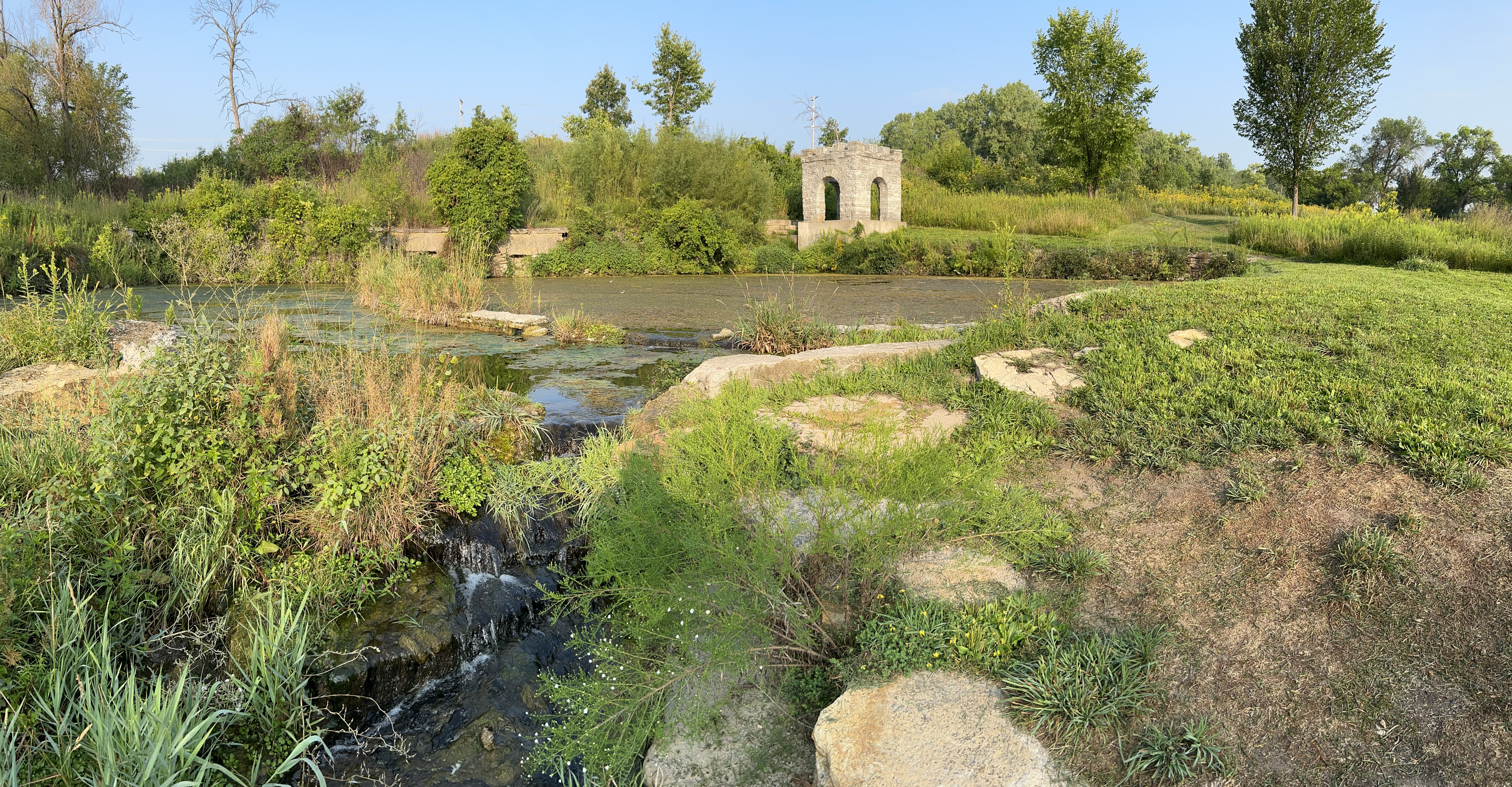
The tiny tributary (above) of the Mississippi River is Coldwater Spring, one of the few parcels of land the park service owns here except for islands. Buildings were removed, plants planted, and the birds and butterflies have already returned. A mink was sighted a few days ago. Having a good spring near the confluence of the Minnesota River made it ideal for an early trading post. Eventually the twin cities of Minneapolis and Saint Paul arose, but, even though you can hear traffic, the spot is mostly wildflowers, prairie grasses, and old Live Oaks.
The trail will be ready in September, so I wasn’t able to walk down to the floodplain to see the Cottonwoods here, but they’re visible in other locations. Nearby are the Minnehaha Falls, named after Hiawatha’s love in Longfellow’s 1/2 imagined and 1/2 native lore mashup epic “Song”. Hidden Falls / Crosby Farm and Lilydale-Harriet Island / Cherokee park partner sites are also recommended for views and other activities. The main visitor center is in the science museum and has mainly kid-friendly exhibits.