Springfield 1908 Race Riot National Monument

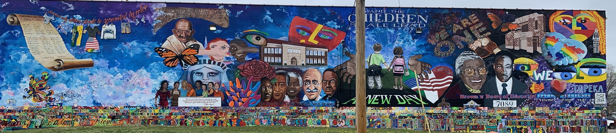
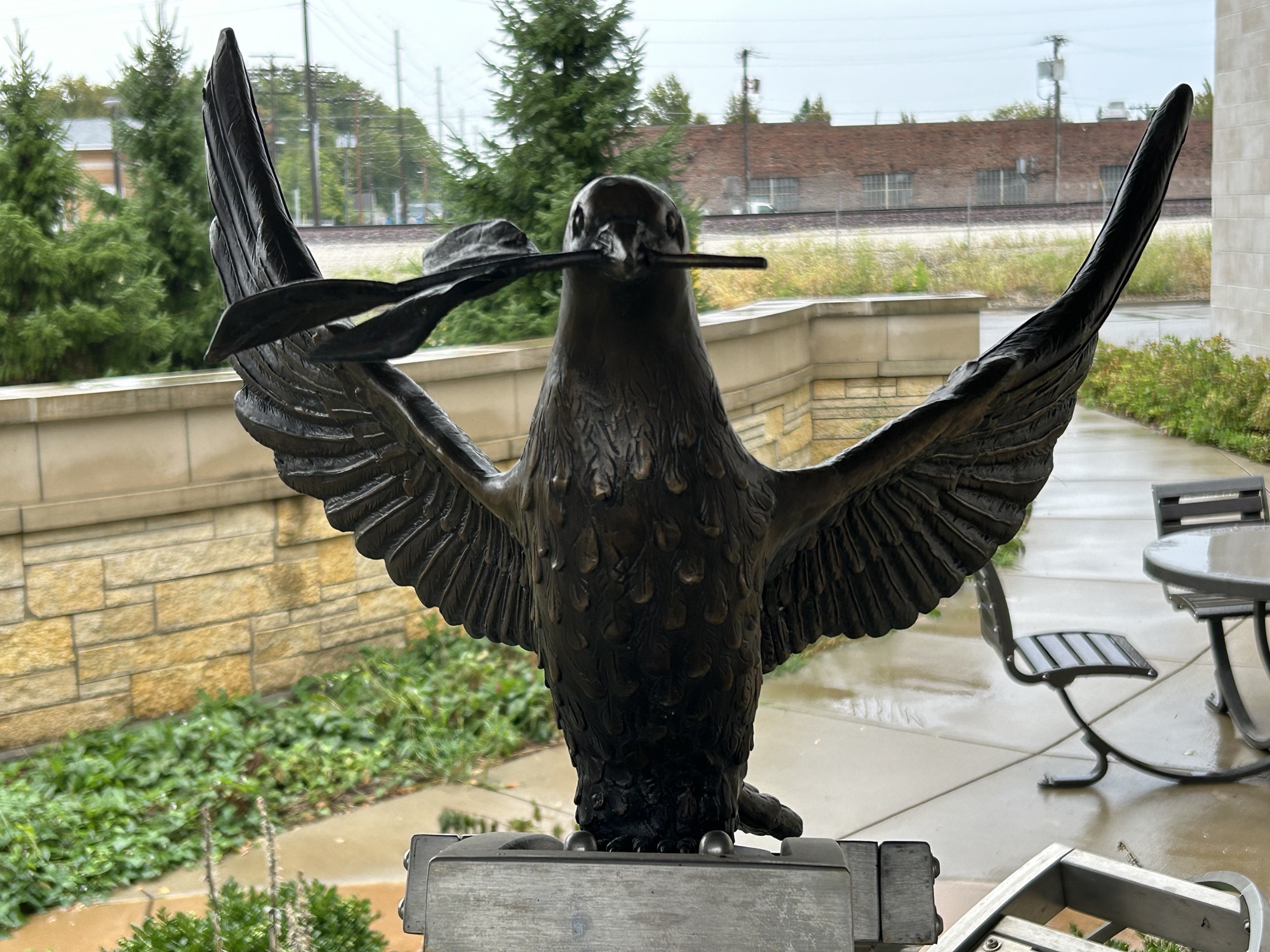
This new park established by President Biden this August is still a fenced off construction area next to the railroad tracks, but there are several art installations dedicated to the riot, including the dove above and a mural at the Children’s Hospital next door. 11th Avenue along the site is known as Reconciliation Way, to commemorate the terrible events here in 1908.

In mid August 1908, in Springfield Illinois, a white mob of five thousand lynched 2 black men, killed 7 others, burned out millions of dollars worth of black homes and businesses and also targeted Jews and whites deemed sympathetic to the black community. The police did nothing to stop the riot. The burning, looting, ransacking and violence lasted 3 days until put down by the state militia, which resulted in 6 dead rioters.

Church leaders blamed the victims for being “sinful”. Although everyone knew the perpetrators and many were arrested, only one 15 year old was convicted after he confessed to stealing revolvers, shooting at black people and starting 15 fires. The others denied any responsibility, the witnesses denied seeing them, and the charges were dismissed. The judge denied that there was racism in Springfield.

Many Americans were shocked by the scale of the violence in Abraham Lincoln’s home town, and civil rights advocates like W.E.B. Du Bois and Ida B. Wells helped form the NAACP in 1909 in response. In 1910 speaking before the NYC Republican Club (the party of Lincoln), Du Bois argued that if racial hierarchy were the natural order of the world, then there would be no need to use social and physical weapons to oppress a race.

“So soon as the prejudiced are forced into this inevitable dilemma, then the real bitterness and indefensibility of their attitude is revealed; they say bluntly that they don’t care what [slurs] may be capable of—they do not like them and they propose to keep such folk in a place of permanent inferiority to the white race—by peaceful policy if possible, but brute force if necessary.
And when a group, a nation or a world assumes this attitude, it is handling dynamite.
There is in this world no force as the force of a man determined to rise.
The human soul cannot be permanently chained.”

W.E.B. Du Bois

Ice Age National Scenic Trail

The trail is not straight. It meanders through Michigan’s wooded hills, green valleys and along its rivers and lakes. The trail begins along the Niagara Escarpment that separates Green Bay from Lake Michigan, then south below Madison, before crossing the Wisconsin River at Lake Wisconsin. Then it passes up across the bluff on the right with its characteristic rough rock glacial remnants on the steep slope to the north beach of Devil’s Lake above before continuing north to the Wisconsin Dells with iconic eroded rocks. Eventually it crosses the state to end at the St Croix River.

President Biden elevated the trail to a full national park unit, but many of the most scenic sections are in state parks or affiliated scientific reserves. Wisconsin Dells itself is quite commercialized, with water parks and pricey tours, even though the layered rock can be seen in several different places along the Wisconsin River. State parks like above or Mirror Lake have fine scenery, camping and miles of maintained trails. I tend to rush around and then spend too much time at supper clubs, but it’s worth slowing down a bit here to enjoy the natural beauty. For more, read my earlier post about the Ice Age Trails.

Pictured Rocks National Lakeshore

Superior is the biggest, deepest and cleanest of the Great Lakes, and our most scenic lakeshore park is on the north coast of the upper peninsula of Michigan. Within the park are ~10 miles of dramatic 200’ cliffs, painted by various minerals washed through the sandstone, and the best way to see is by boat. The pastels, turquoise shallow waters, green trees, blue skies and waterfalls (below) are spectacular.

Besides taking a popular commercial tour of the most scenic section of the cliffs in a couple hours, as I did, it’s possible to kayak or to hike along the edge. Lover’s Leap (above) has only 3’ of water below, so don’t take it literally. The lakeshore trail—part of North Country NST—is 40+ miles over dunes, creeks, and long beaches, with many side trails exploring forests, marshes, and lookouts. Short hikes can be done near the ends of the park, but the middle is roadless.

Midwest Region National Heritage Areas

The Midwest region has 8 NHA’s—more than most regions—ranging from industrial to pastoral, and most are devoted to travel by horse, boat, car or plane. Each heritage area provides a unique way for us to learn our history and explore our diverse culture in vibrant and interactive ways, such as riding in a Santa Fe Trail stagecoach above. Parks travelers tend to focus on the most famous iconic national parks, but I found some of my most treasured experiences below.

If you missed any of the posts above, I encourage you to click on them now, especially the last one. I’m slowly filling in the map and will continue posting Midwest state photo summaries on alternate Saturdays. I only have a few more Midwest national park units to post before I complete all sites in the region, and look for a few more New York sites. Thursdays will alternate between summaries like this one and eclectic extras like last week.

Apostle Islands National Lakeshore

Above is the northeast point of Devils Island, the park’s northernmost island. The sandstone is more finely layered here, a bit softer and exposed to Lake Superior, so it erodes into caves, arches and beautiful shapes, under the lighthouse, quite photogenically. I briefly considered taking my own boat, but the distances are more than I realized. The largest island (left out of the park) is roughly the size and shape of Manhattan, with “1.5 hundred residents”. One does not simply paddle into the Apostles without serious preparation and proper gear. So, like most tourists, I took the efficient new catamaran from Bayfield. (While I arrived without burning carbon, I sometimes use park transport to enjoy places). The tour lets you see many of the 20+ islands in just a few hours. Guided kayak tours are also available.

Several of these beautiful Wisconsin islands are off limits, but most have one or more individual primitive campsites accessible by kayak, private boat or water taxi. Some of the wildlife is very difficult to see; martens weren’t seen on one until wildlife cams were installed. But from the comfort of the tour boat, we stopped to turn around and get a good look at a bald eagle nest, with a nesting pair visible. We also saw mergansers, nesting gulls and other birds. Bear and deer are only rarely spotted while swimming between islands. This is a large and important refuge for species that were once common all around the Great Lakes, and getting out among the islands is easy and worthwhile. If you have the chance, the colorful old Greunke’s Inn, near the dock, serves whitefish liver, a delicacy they popularized in the 1940s.

MotorCities National Heritage Area

Behind “Elizabeth” above is the secret room where Henry Ford designed and built the first Model T in his factory on Piquette Avenue on the then outskirts of Detroit. His buddy Harvey Firestone got the first ride, and then Ford road-tested the vehicle by driving through Wisconsin to the Upper Peninsula on a hunting trip. (Along with the influential naturalist John Burroughs and the inventor Thomas Edison, the four were close friends and camping buddies). Then, introduced in 1908, the Ford Model T took over the US car market.

Roughly half the price of a horse-drawn carriage (including horses, shoes and fodder), priced lower than competing cars, and offering useful attachments like truck beds, skis or tractor wheels, folks loved the rugged, practical vehicles. Ford had already built models B, C, F, K, R, N and S in this factory, but a lighter weight steel allowed him to build the vehicle he knew would be popular in rural America (Ford grew up on a 200 acre farm), the Model T, with 6 models ranging from $825 to $1100: the Roadster, Tourabout, 5-Passenger Touring Car(above), Town Car, Coupe (popular with doctors) and Landaulet (taxi). The original Model A that had been built down the road in 1903 was redesigned and reintroduced in 1927 to replace the Model T as another commercial success. Of over 100 car makers in Michigan when Ford started, his is the only original firm remaining.

By making the popular standard car, Ford determined the direction of the industry. His wife insisted the steering wheel be placed on the roadside, so that when he drove she didn’t dirty her dress while stepping to the curb. Instead of alternatives like steam-punk coal-burning vehicles or electric vehicles—several of Ford’s earliest vehicles were electric—, gasoline was readily available across the country for small machines and farm equipment. Before realizing that black paint was cheaper and dried quicker, red and green models were also sold, often with raw white rubber tires, as above. After making various improvements to the assembly process here, Ford designed his next factory with steel-reinforced concrete floors to bring parts down to the world’s first synchronized assembly line. While this fascinating heritage area includes many different car museums, the Piquette Factory tour must be considered the highlight, with two dozen early model cars built here on display over 100 years later.