Bryce Canyon is spectacular in April with a chance of snow on the hoodoos. The best of Bryce is a horse or better a mule ride down into the canyon, and the park concessionaire starts riding tours on April 1. The canyon rim is around 8,500 feet, so late snow and leftover morning ice are quite possible. Except for a couple roads up to mountain peak lookout trails, the park opens for spring between the end of the first week and mid-April. If you are a serious hiker and want all the trails open, then I’d recommend the first half of October before the snow falls. Otherwise, I’d check the weather, wear a thermal layer and go in the second half of April, when wildlife and flowers are just emerging after a cold winter. May or September are also nice, as they are at most parks.
Canyonlands has good weather in April and has many different places to explore by bike, drive or hike. The roads and trails are often rough especially after rain, but there are wildflowers. Campgrounds require early reservations and background camping requires permits, gear and experience.
Capitol Reef has some excellent hiking in April ~65° F. There may be some rain, but that brings wildflowers. Some like visiting the orchards in fruit picking season, but I’d rather be biking here when the orchards are in bloom.
April has pleasant weather for taking photos of the Petrified Forest with wildflowers. Summer is too hot and winter is too cold. You need decent weather to hike around, and the contrast between the fossilized trees and living flowers is nice.
First Saturday of the month, so here are the three National Parks best visited in March. See January and February for more.
March is a tricky month for parks, as many parks are still in winter or are too cold and wet to enjoy. But in the west at higher elevation, spring comes earlier and a few parks are fairly dry year round. Arches, Joshua Tree and Pinnacles are my March park picks.
Let’s be honest, an enjoyable experience at Arches is all about parking. Ideally, you want to stop at each arch spot, hike a bit, take photos and then move on to the next. If it’s overly crowded, that can be difficult, even with timed entry or arriving at sunrise. Since it’s too hot in summer, the shoulder seasons are crowded. Winter is too cold, and slick rock trails are dangerous when there’s ice. The solution is March. Snow is rare, but it makes a better photo if you see any on or through an arch. Temperatures are fine, with most daytime highs in the 70° F range. There will still be plenty of people, but not nearly as many as Spring Break. Sure, fall is fine too, but you could say that about most of the parks.
Joshua Tree is a great spot for hiking and camping, but the campgrounds are mostly at ~4,000 feet. So winter is uncomfortable, and as the park is in the Colorado and Mojave deserts, summer is uncomfortable too. I prefer March, when you can see wildflowers. The trees and rocks are great, but it’s even better to find a pretty little flower unexpectedly blooming off some rough trail. Like Arches, the park is popular and crowded at Spring Break.
Pinnacles similarly is high, relatively dry, and has limited trail side parking, so I like March there before Spring Break. But there’s a special reason to go in March (or maybe October), as the entire Bear Gulch cave is open. My favorite part of Pinnacles are the caves, but due to bats raising their young, many underground areas are off limits for months of the year. The weather is fine for hiking too, and you can see wildflowers.
Hope this series helps you plan your next national park adventure!
On the first Saturday of every month, I recommend 3-5 parks to visit in the contiguous US, matching each of 51 parks with a great month to visit, as I did in January.
There are a few parks in the US which are dangerously hot to visit in the summer, but they’re perfect in February. In the west, especially at elevation, the coldest day of the year is often in December, and by February the southwest deserts are just beginning to bloom with wildflowers.
Big Bend, Death Valley, Saguaro and White Sands are my February favorites. These are beautiful parks, and you’re going to want to get out, hike around and take fabulous photos, without risk of heatstroke.
Big Bend is huge and takes time to explore, so you need to schedule several days there. Unlike most other parks, the full range of activities are open in February, including rafting and horseback riding. In February, the park’s daily temperature variations still stay in a range that allows you to explore the varied terrain. When I was hot, I spent time along the river and enjoyed sunset in the mountains. On cool days, you could go on a more challenging scenic hike. If camping, prepare for beautiful cold nights under clear dark skies. It’s a great park, and February is a great month to see it.
Death Valley daytime highs are around 70-75° F in February. Wildflowers bloom and even super-bloom when the rains have been good. The high Panamint mountains in the background of your photos will have snow-capped peaks as they cast a rain-shadow over the valley, keeping it extremely dry. Every February the park holds stargazing festivals, as the skies are exceptionally clear.
Saguaro also has many wildflowers in February, and the comfortable daytime temperatures mean the coyotes, javelina and roadrunners are more likely to be roaming around. Some say May is when to go in order to see the Saguaro cacti bloom, but there are many other great parks to visit in May, without any risk of over 100° F days. If you’re really interested in seeing the small Saguaro flowers, you can probably find a botanical garden to visit close to home.
White Sands, to me, is about stepping out on the other worldly landscape, so the solitude of February is best. It’s cold at night, but there’s no camping currently in the park anyway. As it’s quiet, there aren’t a lot of ranger-led hikes in February, but White Sands is best appreciated in silence. Many visit a bit later in order to see some wildflowers, but the gypsum desert does not allow much life. I’d happily trade the crowds of spring for easier parking and fewer footprints in February.
We visit national parks to be out in nature exploring, so good temperatures are very important. February is the perfect time to visit these southwestern parks which are dangerously hot for much of the year.
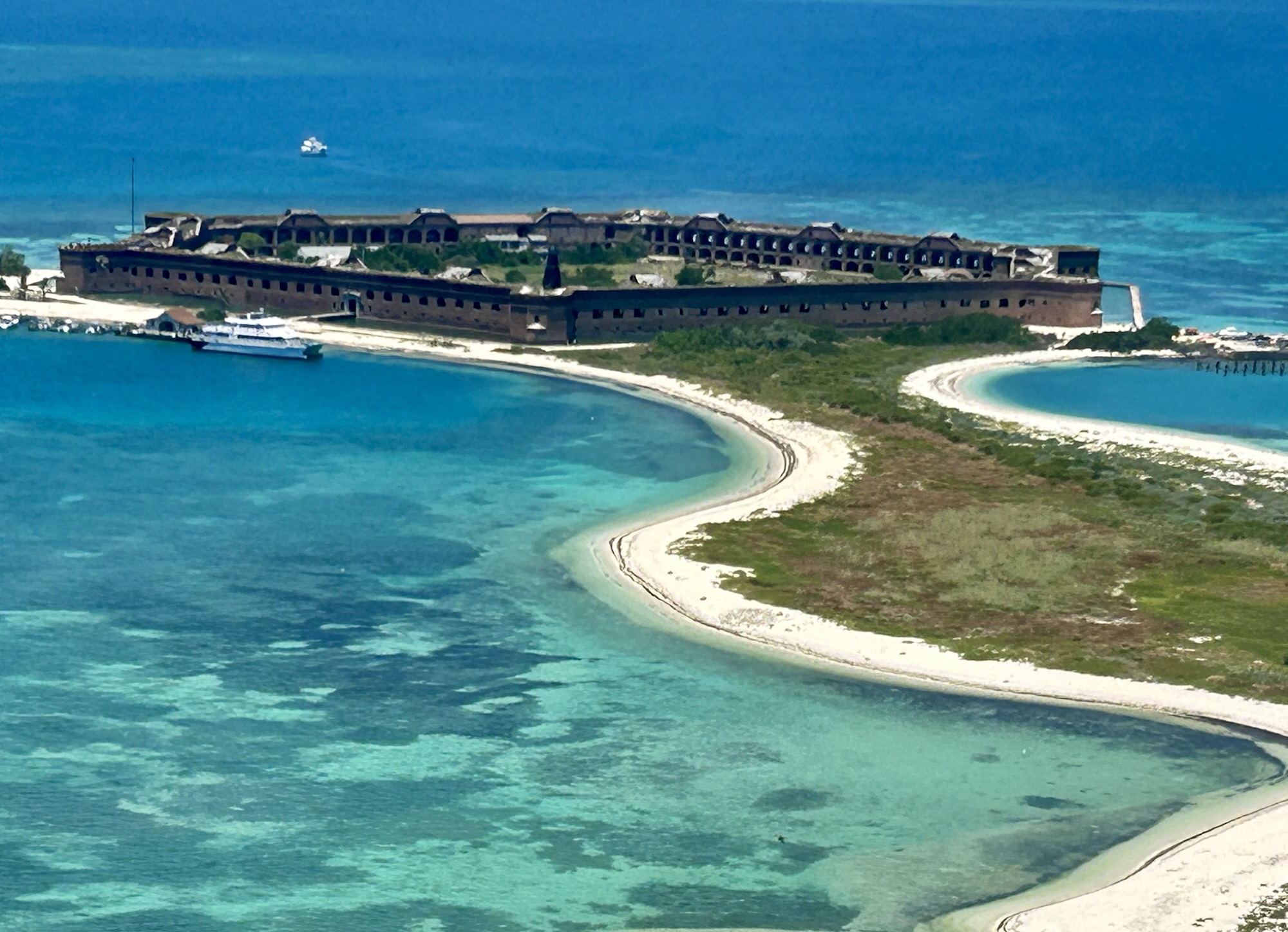
Fort Jefferson is an impressive 19th century structure, used to police ship traffic between Florida and Cuba. The island was named for the sea turtles that still nest here, and there are many seabirds too. There are lovely views of the courtyard above and all around the small island from the top of the walls. I was pleased to see a goliath grouper near the ferry dock, and despite the poor coral condition, the snorkeling was very good among the old dock pilings near the south beach. Together with the Everglades, Dry Tortugas is a large UNESCO Biosphere. I saw hundreds of fish and birds. This is one of my favorite national parks.
The flight is much more expensive than the ferry, but there are some benefits. I was kicking myself for not reserving ferry tickets enough months in advance, but when I realized that the seaplane only flies a hundred and fifty feet or so over the shallow waters, I decided the short flight was worthwhile for the views. From the air, we saw two shipwrecks, one a navy boat used for target practice and the other a famous treasure hunter’s floating guard shack, plus many sea turtles, some sharks, maybe a stingray, a pod of dolphin, and flying fish scattering over the surface. First time for me to see all that from the air. Also, the flight saved me a lot of time. If you’re just visiting Key West—I took the Conch Tour decades ago—to get to the Dry Tortugas, then you can drive in, catch a 10 am flight, and be on your way, saving two very expensive hotel nights on Key West. Plus, it’s less crowded when you first arrive, they include snorkel gear—definitely snorkel—, and you get the view of the fort below.
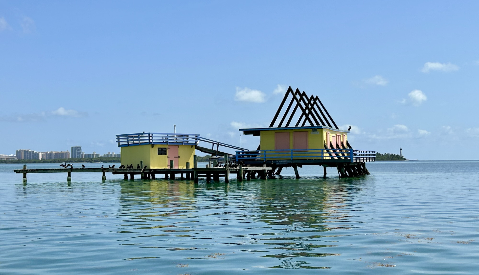
A few stilt houses have survived hurricanes and are allowed to remain in this huge marine park just outside Miami. The lighthouse in the background was once part of the Underground Railroad, as boats would risk the reefs to come here at night to pick up escaped slaves and fleeing Native Americans to live in the Bahamas, which ended slavery in 1834. While the Key Biscayne in the background above is a barrier island, the Florida Keys are part of an ancient reef that begins here, includes Key West and runs to the Dry Tortugas.
The best way to see the park is by boat. I took a very small tour from Coconut Grove out to the flats, to snorkel on both ocean and bay sides of Elliot Key, and had lunch on Boca Chica. The reef I remember from the 1980s has been devastated by carbon pollution from fossil fuels—elkhorn & staghorn corals are functionally extinct here now—with widespread coral bleaching and only a fraction of the marine life. But it still has life. I counted dozens of species including a beautiful French angelfish, various colorful parrotfish, spiny urchin and a lobster. From the surface we saw mating loggerheads, a manatee, and many birds, but the vast majority of wildlife is just below the surface. Let me show you what I mean.
The southern end of Florida is home to Everglades National Park, which is also a UNESCO Biosphere and a World Heritage Site. Since 1900, the area has been both protected and threatened, with political battles needed to protect bird plumage, to create the park, and to protect the large, diverse ecosystem here. Marjory Stoneman Douglas wrote a book to explain how the Shark Valley River Slough runs as a “river of grass” through the Everglades. When summer rains fill Lake Okeechobee, a sheet of water overflows the low bank and floods the flat grasslands, revitalizing fish eggs and a whole ecosystem. A cross Florida road called the Tamiami Trail prevented that flow, and a political battle was fought to restore it partially. The fresh water eventually sinks through the limestone, filling the Biscayne Aquifer to provide drinking water for Miami. There are also canals crisscrossing lower Florida, including here, and that’s where these two young alligators were hanging out. Alligator Alcatraz, a temporary migrant detention center, is in the Everglades ecosystem, but it’s not in the national park. Alligator Alcatraz is north of the Tamiami trail in Big Cypress National Preserve.
The park is 1.5 million acres, including the mangrove islands that form the southern end of Florida, before the Keys. The best place to see the mangroves is by boat, either from Everglades City west of Big Cypress or by driving to Flamingo. I took my family to the latter, and we saw a large crocodile near the dock, plus much more wildlife on a quick cruise in the “submerged wilderness” of Florida Bay. Personally, I wouldn’t kayak these waters, but many people do, camping on the Chickees or raised bits of ground where natives camped seasonally and for different purposes for centuries at least. There’s even a paddling waterway to go between Everglades City and Flamingo. Before the highway was built out to Key West, visitors commonly took a similar route by boat.
The work of environmental protection is never done. Burmese pythons entered the park in the 1970s—likely as discarded pets—, and now they’ve wiped out most of the native animals, threatening the Florida panther with extinction. I was disappointed to see the dramatic decline in wildlife evident from the Shark Valley Tower, since I first visited decades ago and even since I visited again with my family not so many years ago. And since last year, the state government is not allowed to mention climate change, global warming or sea level rise, but that obviously won’t do anything to prevent rising sea levels from submerging much of southern Florida, including most of Miami and almost 1/2 the park in the coming decades. Especially if the government refuses to take action, climate science clearly shows that the environment will only continue to worsen more rapidly.
Kayaking around Scorpion Rock, above, is truly a great national park experience. You are completely surrounded by wildlife, with brown pelicans flying in formation above, various seabirds perched and nesting on the rocky cliffs, harbor seals and California sea lions popping up curiously, and a brown kelp forest below with colorful sea stars and garibaldi fish. Our adventure tour had us on the water for several hours exploring both east and west of the scorpion ranch dock. Due to a fault line running through the volcanic rock, combined with powerful waves, this particular corner of Santa Cruz Island has perhaps the largest concentration of sea caves in the world, and I kayaked past a big blow hole, through several arches, skirting a gyrating whirlpool, around a pillar, and far enough into the back of one cave that the entrance almost disappeared in the swell. Wonderful!
If that’s your cup of tea, get in touch with the Santa Barbara Adventure Company, who can arrange a whole day tour, my favorite paddling tour. The guides were excellent, despite being frequently interrupted by seals and sea lions, and offered memorable stories to explain what we were paddling through and to inspire us to pay closer attention and care more about the natural world around us. Some flexibility helps, as weather can affect camping, ferry crossings and kayaking conditions significantly. The ferry operator contacted me the night before my trip to advise me of a storm that would bring hazardous winds, rains to turn my campsite to mud, and the likelihood of a canceled return ferry. They suggested changing to a day trip to avoid all that, so I left my camping gear in my trunk and had a spectacular, slightly rushed, day on the water.
I feared that I would not get to see the Island Fox, but one popped out as we were eating a late lunch (see below). Frankly, I needn’t have worried about not seeing any wildlife, especially on a kayak tour. Black oystercatchers, several different cormorants, the island scrub jay, pigeon guillemots, and a wandering tattler were just a few birds we saw. A large pod of common dolphin greeted our ferry’s arrival at Santa Cruz Island and played in our wake, and I spotted several whale spouts on the ride back.
I recommend arriving the day before your trip, going to the visitor center near the ferry dock, and watching the park film, narrated by a local high school grad named Kevin Costner of Water World fame. There you can learn about the islands, the Chumash cultural heritage, and all that you hope to see. The five Channel Islands are often called the Galapagos of the US, and, having been to the actual Galapagos, I must say it’s not true. There are similarities, including some seabirds resembling penguins, numerous playful seals & sea lions, and the sense of being surrounded by species in an extraordinarily special place, but there are no giant tortoises or brightly colored iguanas or other tropical species. The Channel Islands are unique in their own right, in a Mediterranean climate, on a busy seaway for whales and other marine mammals, remarkably accessible from one of the country’s largest urban areas. Marvelous!
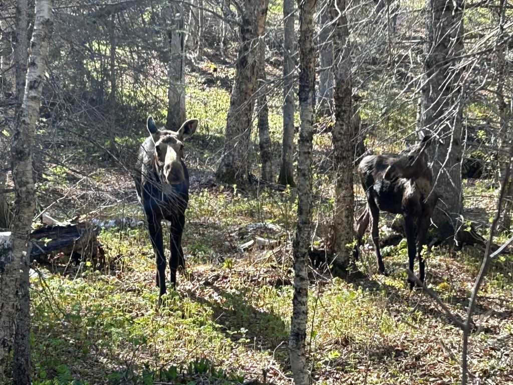
This is now my favorite park for wildlife. I was lucky to get a photo of this moose and her calf on the 1 mile Nature Trail in Windigo just before my boat left. Despite seeing loons, mergansers, swans, geese, and even a bushy tailed fox parading near my shelter on Washington Creek, I had neglected to take any decent wildlife photos, so until these two approached me, all I had was one photo of two ducks: a paradox.
I hiked a dozen miles and enjoyed the pitcher plants and boardwalks through the swampy areas and the mossy boulders on the north shore. The island is larger than I imagined, so be sure to download the park map in advance and charge your phone. This Biosphere is one of the least visited National Parks but most re-visited. Many folks hike the length over several days, and early in the season there were many volunteers hiking off-trail doing scientific research on wolf-moose predator-prey. A few were carrying a canoe for inland lakes. It’s an idyllic place, with hours of silence and solitude, a wonderful trip into the wilderness.
Isle Royale is in Lake Superior, and the shortest ferry ride is a couple hours from Minnesota to Windigo. The island is part of Michigan, and there are also ferries from the Keweenaw Peninsula in Upper Michigan to Rock Harbor. Most visitors are experienced hikers who backpack to their campgrounds, and it’s 40 miles between Windigo and Rock Harbor. Some arrive by private boat, and several campgrounds have docks. Lodgings are limited to Rock Harbor and a couple cabins in Windigo, and rooms are both very expensive and typically sold out many months in advance. The season roughly runs from early June to early September, so it’s a good idea to plan your trip a year in advance.
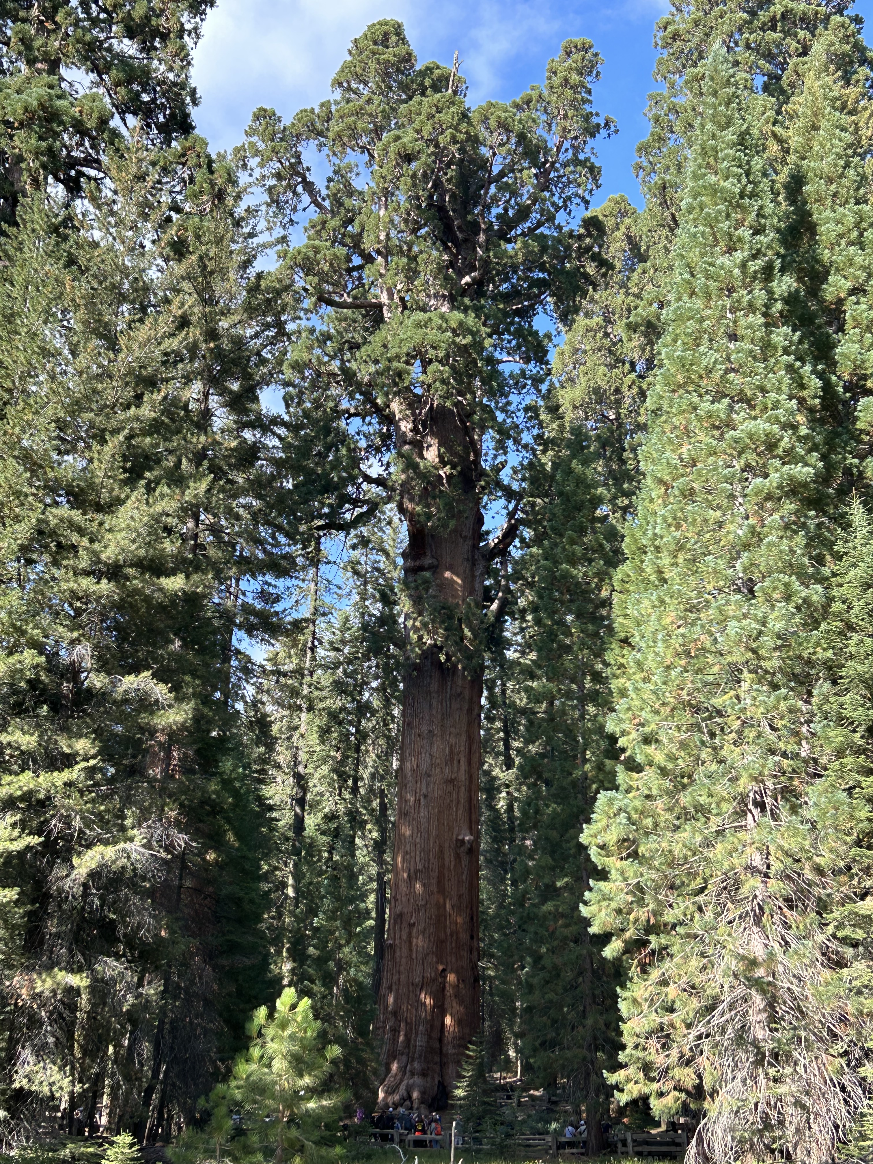
General Sherman, the Giant Sequoia above, is the largest living single organism on earth. Over half of the largest trees on earth are in this park and in neighboring Sequoia National Monument, Sequoia National Forest and Kings Canyon. This park is my favorite for giant trees. For millions of years, these magnificent trees thrived here, near the southern end of the Sierra Nevada—‘jagged, snowy’—mountains. The taller, thinner coastal redwoods mainly live closer to the Pacific where cool ocean breezes bring fog, protecting them.
But in a small fraction of one Giant Sequoia’s 3,000 year lifespan, humans have burned so much carbon into the atmosphere that the mountains here no longer hold snow all year, serving the immovable trees an eviction notice. Just in 2020-2021, between 13% and 19% of the world’s Giant Sequoias were burned to death in consecutive huge wildfires here. These trees evolved to survive fire, and, until recently, mature Giant Sequoias survived wildfires. The Climate Crisis has changed that, putting this species at risk of extinction in our lifetimes.
Many of the groves and much park wilderness are currently unreachable, due to post-fire erosion washing out roads, bridges and trails. Finding sections of the park unmarred by burn scars is challenging. The trees here are magnificent, but I recommend visiting Redwood to find solace. While most of our Giant Sequoias still live here for the time being, please don’t burn gas to get here. The last giant forests the loggers failed to destroy with sawmills, we are destroying with our cars and airplanes. By choosing to burn carbon, we are destroying the ecosystem these magnificent trees needed to live naturally for thousands of years. It would be too sad to visit only to say goodbye.
John Muir loved the view from Panoramic Point above, as did Stephen Mather, the first national parks director. I visited the park years ago with my family, and the scenery was stunning. But the view was less inspiring when I visited this summer. Smoke from a wildfire shrouds the view of Kings Canyon in the distance. You can hardly see the lake in the photo above. Behind me stand acres of dead trees burned in the huge wildfires of the past few years, and the main road into the heart of Kings Canyon wilderness was still closed this summer due to fire damage. If Muir & Mather visited now, they would be as heartbroken as I.
Experts employed at this California park have long argued influentially in favor of more fires, have implemented prescribed burns in forests across the west, and they chose to let the wildfire above burn itself out. Their dogma blamed past firefighters for causing today’s wildfires. Even though park rangers are not allowed to smoke, leave campfires unattended, burn out shelters in trees, or use fire to hunt, this park’s scientists used to argue that we needed those ‘Native American burn practices’ for forest health, even though these forests evolved without humans. Too many forest rangers and climate change deniers use this illogical nonsense to ignore and dismiss the danger of carbon.
This year 46 million acres of wilderness forests burned in Canada in roadless wilderness areas consistently ignored by firefighters in the past. How could these wildfires have been caused by past ‘fire suppression’? The dogma is wrong. After the unprecedented recent wildfires, park scientists here have belatedly begun to recognize the predominant threat of climate change, far worse than any prior suppression errors.
When Muir & Mather described the area, they did not remark on seeing any large areas of burned trees, made no note about any fires that regularly demolish many thousands or even a million acres every few years, and they did not write about the supposed benefits of Native Americans regularly setting fires while pelt hunting. Instead, they were inspired by the beauty of huge swaths of living forests and pledged to protect them forever. Scheduled fires, tree density limits, species removal, reseeding, and other human intervention are not what Stephen Mather had in mind when he called such places ‘untrammeled wilderness’. Muir would have harsh words against the ~$250 million annual timber sales in the forests he and Teddy Roosevelt protected.
If Muir & Mather could return, they would notice that the whole forested range has changed dramatically, the air and ground are drier, the temperature is unseasonably hot, the rivers and creeks are dry, and that the snow is gone from the mountaintops. They would be dismayed by the decline of once abundant wildlife. Muir, who never rode in cars, preferring horses or hiking, would see the lines of buses, RVs and cars burning gasoline, and he would shout ‘STOP’!
In the future, doubtless people will be horrified to learn that in the face of climate change fueled wildfires, we chose to burn our remaining forests ourselves, releasing even more carbon into the air. It’s like using leeches to cure people, even though they make the patient weaker. Or like destroying the village to save it.
Forest science must face the future, not misrepresent the past. We need national policies to limit carbon pollution, not taxpayer-funded ‘prescribed burns’ that increase carbon pollution. If new conditions require fire breaks or dead trees need to be removed, then why can’t trees be cut down and buried with sand, instead of being burned? If certain types of trees will no longer survive in the future hotter climate, then we shouldn’t be paying people to plant seedlings for more of the same trees in the same places that burned down two years ago. We need to charge visitors in gas-burning vehicles a carbon surcharge to encourage people to switch to electric vehicles (and to mitigate some of the damage they do).
We ended wilderness. Our carbon pollution is trammeling every species on earth. We have precious little time remaining to figure out how to save species before they go extinct forever.
“Without wilderness, we will eventually lose the capacity to understand America. Our drive, our ruggedness, our unquenchable optimism and zeal and elan go back to the challenges of the untrammeled wilderness.”