Salinas Pueblo Missions National Monument

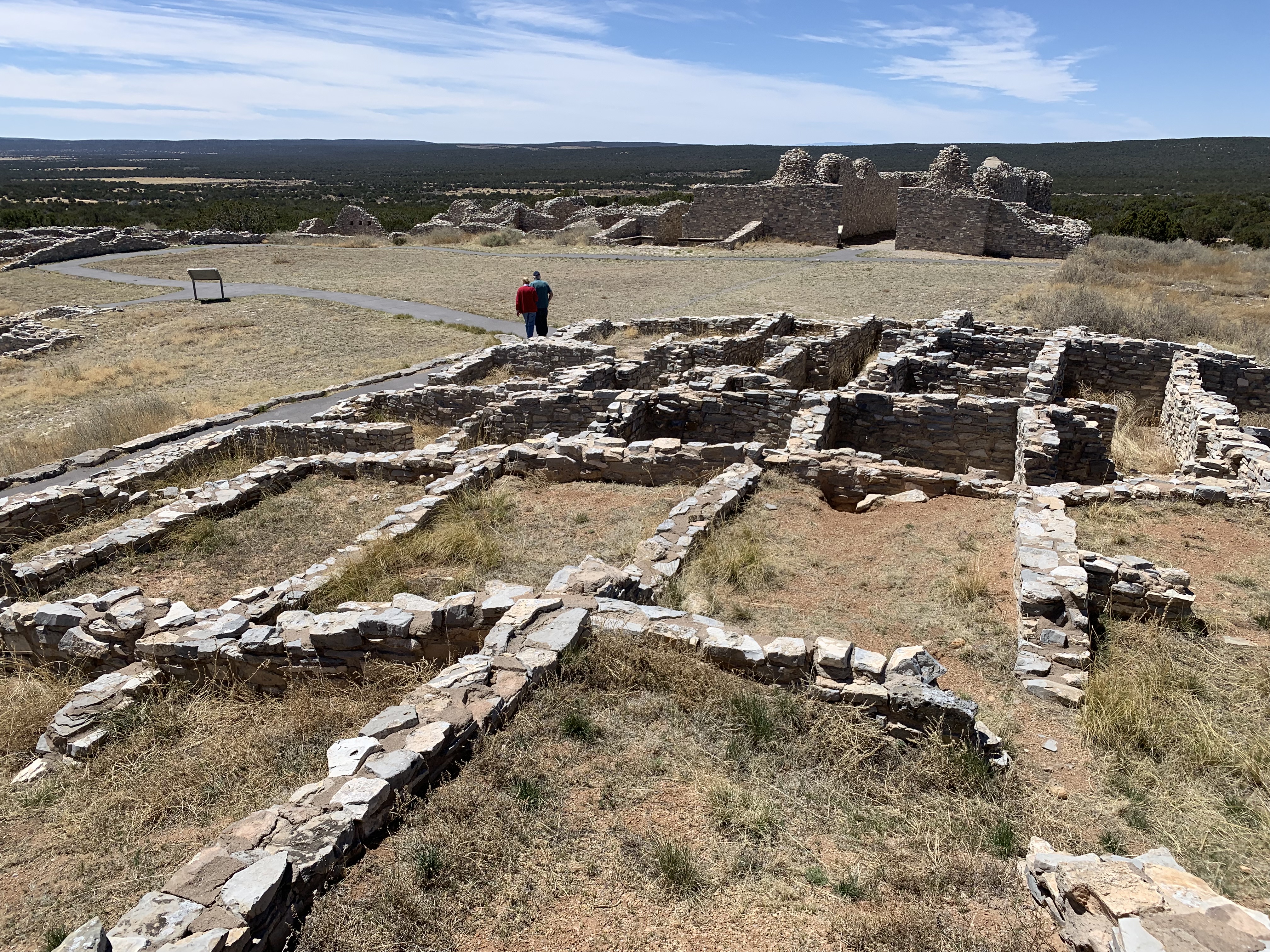
I chose to visit Gran Quivara, since it has the largest pueblo ruins of the three missions, although the churches are better preserved at the other monument sites. The original pueblo ruins are in the foreground. The Spanish claimed the land for the King and forced the people here to build two churches, first the low ruin to the left and then the taller structure in the back. Some accounts describe the relations between the natives here and the Spanish as friendly and positive. From what I can tell, it’s hardly a coincidence that the pueblo was abandoned a few years after they started constructing the larger church for the missionaries. The local people endured Spanish diseases, grew Spanish plants that were ill adapted to the drought-stricken area, and other native tribes mistreated or attacked them as collaborators. They were prohibited from practicing their own religion, including singing native songs or performing dances, due to the strict rules of the Spanish Inquisition. If I had to go through any of that, I would leave too.

El Malpais National Monument

The caves were closed by Covid, but I enjoyed the hike and wildlife. There’s a private site nearby that apparently is still conducting “ice cave” tours. I’m happy to leave the bats alone underground and not risk introducing fungus or disease. I suppose it’s ironic to have the cave closed here when Covid likely originated from a bat cave in China. But the larger problem is that climate change is spreading more diseases globally, affecting both us and other species, so we need to be more responsible.

I should add that beyond the borders of the monument, there are both wilderness and conservation areas protected in El Malpais, meaning badlands.

El Morro National Monument

This rock is interesting. Rock climbers would enjoy the many tall vertical crevices. There’s a spring with a pool in an alcove at the base. At the top, there’s a ruin with a good view of the surrounding valley. And all along the base there are carvings made centuries ago by travelers, from those who didn’t have a formal written language, to Spanish speakers who named this place ‘El Morro’ meaning ‘the hill’, to other pioneers.

This park unit has nine free campsites in a pleasant loop with toilets, tables and water (except during the winter). Since New Mexico offers many electric sites at their reasonably priced state campgrounds where I can charge my EV overnight, I generally try to stay there. Sometimes I stay at a private RV campground, and sometimes I stay at a hotel, especially when I really need a shower. The Tesla easily powers my 12v camping fridge. The least common denominator everywhere is a toilet and a trashcan. The model 3 is small, but I manage to sleep in it. Without a big rig to pull, I can easily park anywhere, and I don’t have to burn a gallon of fossil fuel every 10 miles.

Aztec Ruins National Monument

Again, we keep using the wrong name for a national park site (like Montezuma’s Castle). The Aztecs had nothing to do with building this pueblo or reducing it to ruins. By now, I’ve had it. Even the park service uses the term “Indians”. Well, Indians are from India, and we’ve known for centuries that Columbus was wrong to believe the natives he encountered were from the Indies. Geographically, it’s difficult to find two places more diametrically opposed on our globe than India and New Mexico. It’s frankly insulting to keep referring to people by using a mistaken term for centuries. And it shows a profound and reckless disregard for addressing past mistakes and thinking about how to correct them, when we continue making the mistake every day. I’ve been using the term “Native Americans” to discuss the people who still live here and still practice their religion at sites like these. In Canada, the official term is “First People”, which is certainly an improvement in accuracy. Navajo use the term “Diné”. Unless we’re referring to the south Asian country of India, we need to stop saying “Indian” now.

Rant over. The ruins are primarily worth visiting in my opinion to see the spectacularly restored Kiva pictured above, as well as to duck through a long row of low doorways to explore the many rooms along the longest wall here. If you have time to visit a number of these native cultural sites in one trip, then you begin to get a fuller picture of the various migrations, trade routes and pueblos along the river valleys. Each park visit helps open my eyes to both the ancient people and their living descendants.

Canyon de Chelly National Monument

The canyon is sacred to the Navajo. As is too often the case with Native American places, the name is confusing. De Chelly (pronounced ‘du Shay’) is from a Spanish borrowing of a Navajo word meaning “canyon”. So, many people out there are mispronouncing a word in two languages in order to try to say “Canyon Canyon”. This is my favorite canyon.

I only made a brief stop at Antelope House Overlook on the north rim to get a photo of this spectacular canyon. Fortunately, I toured the canyon a few years ago with my kids. That’s really required to experience the history, culture and beauty. Our guide was a Navajo who explained some of the history and beliefs of her people who still live in the canyon. Although Kit Carson’s troops cut down the peach orchards and modern people have diverted water, the bottom of the canyon is still both productive land and a protected ecosystem. If you have the time and money, a horseback tour would be incomparable.

I don’t normally talk about traveling between park units, but the drive from the canyon to Farmington was spectacular. The combination of green forests, snow, and red & tan rock formations in the winding mountain pass is stunning, as was the view of Shiprock on the other side. I feel some sense of culture shock when passing through Navajo Nation, accentuated by the stark differences between communities on each side, and this time felt acute.

César E. Chávez National Monument

I returned here today to see the exhibits, as they were closed when I visited last year. The black & white photos of the Delano grape strike and Chávez’s hunger strike remarks are particularly moving. Pesticides were not regulated at all then, and labor was denied rights by growers. Chávez’s national boycott of grapes helped change both.

Today, growers drain rivers, lakes, wetlands and water tables, even as the western half of the country suffers in drought. In Kern County, where the Monument is, the Kern River no longer flows to the Kern Lake, due to diversion for agriculture. In order to sell more produce, growers are ruining the environment for fish, animals and people. Climate change and some farming practices also exacerbate Valley Fever, a deadly fungal infection spreading in California & Arizona.

Agriculture is a trillion dollar industry in the US, with $150 billion in exports. But Big Ag prefers to blame Democrats, rather than face the fundamental challenge of the climate crisis. Big Ag needs to convert farm equipment to electric, and they need to stop using fossil fuel to ship their produce around the world. They also need to cooperate to restore wetlands to sequester carbon.

César Chávez devoted his life to raise awareness and lead civil disobedience to make change. He acknowledged that in the struggle against the rich and powerful, poor people only have their lives “and the justice of our cause” on their side. Today, we need more people to be just as devoted to stop the climate crisis.

Wisteria, photographed in my previous visit in 2021.

Click to see my photos of all national park units in California, or click to read an updated site visit here.

Chiricahua National Monument

This hiking paradise of rocks left me feeling inadequate. Something about the vast number of enormous towering spires of hard rock made me feel like a tired old man. Sure, the view of any one of these mighty columns pointing skyward for ages is impressive, and the variety of sizes, shapes and textures of these huge protruding knobs is remarkable, but the well-endowed phallus-shaped columns left me feeling cold and small by comparison. On the other hand, a bevy of older ladies were very excited and pleased to view the tall and stout structures from Massai Point Nature Trail, as they laughed and reminisced about their youth.

One would be remiss for not explaining that the Chiricahua are the tribe of the Apache Chief Cochise and the feared raider Geronimo, who conducted guerrilla warfare against the US in this territory. For 24 years, the Apache skirmished with and hid from the US Cavalry, attacking stagecoaches, wagons, Mexico and even Union troops in 1862. The rugged and remote territory (below) shows the difficulty the US had in tracking them down. Eventually both were forced onto reservations. 

Click to see my photos of all national park units in Arizona.

Gila Cliff Dwellings National Monument

This park is surrounded by real wilderness, and any intelligent visitor would plan on camping overnight to take a longer hike or maybe even a trail ride on horseback. Of course, I drove through on my way back to Arizona, practicing my hairpin turns on mountain switchback roads. Well, at least I didn’t burn any species-ending fossil fuels on the drive.

The cliff dwellings are spectacular, with details like a wall mural and a pictogram, well worth the brief hike along the pretty creek and up the cliff side. Unlike Montezuma Castle NM, I was able to climb right into the main room and climb ladders to peer into the past. There was even a volunteer there who reminded me that pictograms are painted and petroglyphs are carved.

Click to see my photos of all national park units in New Mexico.

Petroglyph National Monument

Worth going to the visitor center first. They directed me to the trail with the most petroglyphs (400+) and no parking fee. Fascinating to see the signs those travelers left so long ago, preserved by the city of Albuquerque, right behind a residential neighborhood.

Another hiker pointed out a coyote, probably chasing the road-runner I saw too. I heard the distinctive “beep-beep”. They should make a cartoon about that.

Click to see my photos of all national park units in New Mexico.

Tonto National Monument

This cliff dwelling was protected by President Theodore Roosevelt, and the lake in the distance bears his name. My maternal grandfather used to read The Roosevelt Bears to me, and he loved the west, wildlife and birds in particular. So it was especially meaningful for me to wake up beside Apache Lake, spot a hooded oriole, and then drive up to the monument in the morning. Despite a wildfire and protective burns in 2019, the wildflowers were beautiful. Unlike Montezuma Castle, visitors can climb up to and stand in the main alcove to inspect the ruins.

Click to see my photos of all national park units in Arizona.