On the Iowa side of the Mississippi River looking across from the high bluffs toward Wisconsin, there are over 200 hundred mounds, round, linear, bird and bear shaped. They are in clear lines straight out from the river, and they date back roughly 1,000 years, evidence of cultural traditions that continued for hundreds of years. Although these sites typically do not make the connection, there are similar sites along the Mississippi and other rivers at overlapping time periods with evidence of trade between them. Bird symbols in particular are found in both modern and ancient Native American culture. Many similar mounds were flattened and plowed under after the land was stolen.
The hiking here is excellent, with many overlooks, including Fire Point above and Third View which looks upriver. The hillock to the right of the path is one of the mounds, first in a long line into the woods. A pair of hawks soared high above. If you can make it a few miles, your chances of seeing deer and other wildlife improve. Since it is a sacred site, please stay on the trails and do not walk over the mounds.
Welcome to Washington DC! I’m staying with my brother here for a few days, visiting monuments and park sites, on foot and by Metro (electric vehicles only). I won’t have time to see everything, so I’m planning a return trip next year. I’m trying to publish a post per day, so you’ll have something to read while I’m on my way home.
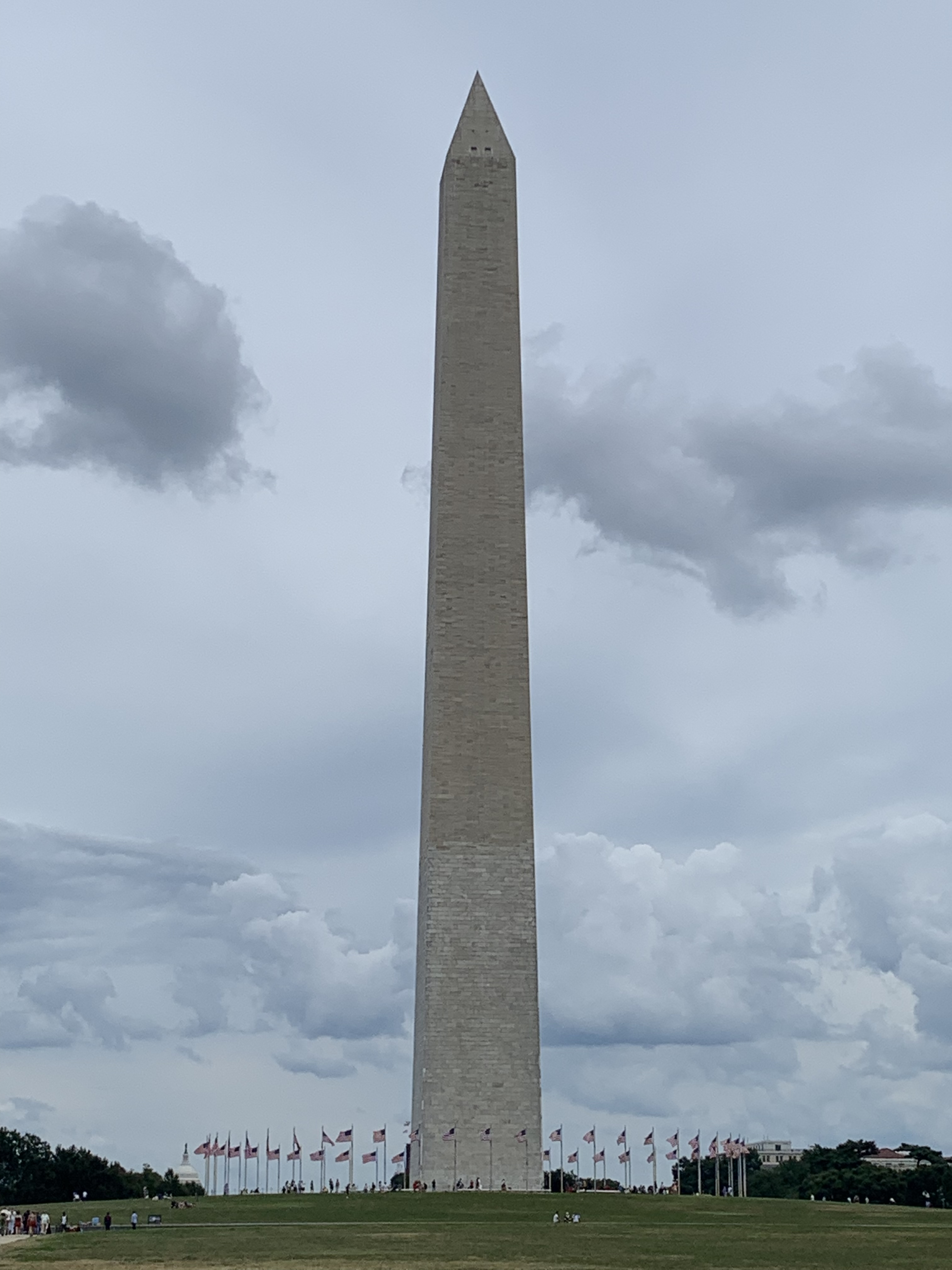
George’s imposing monument above is the tallest structure in the city, and it’s got a great view of the National Mall, from the Lincoln Monument to the Capitol. There are tickets to the top sold at 8:45 each morning, but for $1 per ticket you can reserve up to a month in advance. The windows are small, but it’s still the best way to get a sense of L’Enfant’s Plan. L’Enfant served with Washington as a military engineer, and Washington commissioned him to design the city. His bold vision for the city exceeded the initial instructions from Jefferson, and L’Enfant deserves credit for creating the bold public spaces that define the District of Columbia for both government and the people.
Yesterday I mused about the need ‘to learn from our past to prepare for the future’, without realizing that today I would be looking at a symbol that means exactly that, the West African Sankofa, which is carved above the doorway of return on the opposite end of the memorial structure above. The architect, Rodney Leon, has filled this space with symbols and symbolism, and it evokes the slave-ship hold, the middle passage, the diaspora centered on West Africa and the depth of the remains. When we choose to recognize our roots and learn from them, we can draw strength to be better.
When the burial ground was rediscovered in 1991 and when protests forced the government to change their plans, I was abroad and missed the news reports of the historic find and cultural repercussions. Fortunately, the story is well told in the museum in both the park film and in the exhibits. Government leaders were initially unable to see the pricelessness of the rediscovery due to the value of the land, and the African American community needed to speak out both for their ancestors and for all of us to force the government to respect the remains, preserve the site and honor the contributions of Africans to this city and to our society. The archaeological research, the history of those buried here and some African artifacts are all on display. Facing the emotionally moving subjects daily, the rangers help visitors understand the site’s importance, history and significance.
“You may bury me in the bottom of Manhattan. I will rise. My people will get me.”
If General Sheridan returned to admire his statue, he would likely wonder why there were so many rainbow flags in his park. If he walked into the Stonewall Inn bar (to the left above), he would probably have more questions. But here on the 28th of June 1969, a police raid against the bar for illegally serving homosexuals sparked a riot against police oppression. Unlike earlier riots, a large crowd gathered and forced the police to retreat into the bar. The police called for backup, but the community brought even more protesters who linked arms and fought back. The bar was boarded up, but the protests became larger, as the LGBTQ+ community came out into the open in force to organize marches to Central Park that grew each year. Before Stonewall, some activists had begun staging “sip ins” at gay bars like Julius’ to protest the denial of civil rights and attempts to humiliate and prosecute people based on their sexual orientation. After Stonewall, laws began to change.
The bar itself is still serving drinks with pride, but the site is scheduled to become the headquarters & visitor center in 2024. There are other bars, nice shops and restaurants in the area, and it’s worth taking a stroll and maybe ordering a drink to raise a glass to the brave souls who fought police here. Despite being discriminated against by society and targeted by law enforcement, they demanded and won respect for their rights, bringing more freedom for everyone.
To prevent the British from taking New York (again) in 1812, a fort was built here on a man-made island (since filled in with the park above). As usual, the city reinvented the space several times, as an exhibition hall, an immigration center, an aquarium and as a national monument (where people also buy tickets to the Statue of Liberty & Ellis Island). The exhibit space is basically one room with displays showing the castle’s history, plus a few placards. The rangers are very helpful and knowledgeable, but unfortunately, nobody knew of a way to get to Liberty or Ellis Islands without burning carbon.
Major Armistead insisted on a much larger flag to boost morale. The one he bought was nine times bigger than the small storm flag above the fort today. So when it was hoisted up at 9 am on September 14th, 1814, everyone could see that Fort McHenry was still in American hands, despite almost 2,000 bombs & rockets fired over the previous 24+ hours, from the grateful city of Baltimore to the frustrated British fleet in the Chesapeake Bay, where a young, detained American civilian negotiator named Francis Scott Key watched hopefully, before writing down the first verses of our National Anthem.
These days, big flags mean car dealerships, but after the British burned DC, whether this particular flag was ours decided the fate of Baltimore and of our nation. The film and ranger tour explain the story in detail. One of the air-bursting, shrapnel bombs, turned dud after flying through the rain, still sits next to the powder magazine in the fort. The fort’s flag had only 15 stars, even though there were more states at the time, because few people were particular about such symbolism at the time. But the multi-year ‘War of 1812’ helped spark America’s national identity, the Battle of Baltimore proved us strong and Key’s anthem stirred a deep, enduring patriotism. This is my favorite patriotic park.
Yes, I’m back with a bang! Tesla is still working on my car (Chaco was tough on the springs), but rather than hold me hostage, they’re letting me travel around in a Model S until my car is ready. And the fort celebrates the 1777 victory for two weeks in mid-August with hourly cannon fire!
This fort has it all: drawbridge, sally-port, parapets, ramparts, and meticulously detailed barracks. And it’s open, labeled, extremely photogenic and great fun to climb around and explore. A small crowd gathers just a few yards from the cannon just below the colonial officer walking in the photo, and each step is demonstrated from candle to boom!
Long before we became an independent country, French fur traders gathered at this natural portage between the St Lawrence Seaway and the Hudson River and bought beaver pelts from Native Americans to make hats. I drove up the Hudson River Valley, along the Mohawk River and saw signs for Oneida Lake which drains into Lake Ontario. A short portage here connects the two watersheds, making this a strategic point in the middle of New York State, later connected by the Erie Canal. Control of this portage had international repercussions, as colonial powers divided up the globe.
The British built the original fort after capturing the area during the French & Indian War, and George Washington rebuilt it to defend the territory from the British. The key battle happened when a British Colonel led troops from the Great Lakes to meet with General Burgoyne’s force from Montreal in order to separate New England from the rest of the colonies. Both sides were joined by Native American warriors, and there was a particularly bloody ambush in the woods near the fort. The Patriots defended the fort for about 3 weeks before Benedict Arnold’s reinforcements (when he was still on our side) disrupted the plan, leading to Burgoyne’s surrender at Saratoga. Regardless of which side they fought on, the Native Americans were eventually forced to cede lands in New York, Ohio and Pennsylvania, in return for some annual compensation and limited sovereignty over their remaining land near here.
This little lady is an Eastern Collared Lizard, and she’s sitting on Alibates flint, which is an extremely hard and unusual type of flint used by Native Americans for sharp edged tools. These flints were used to hunt Mammoths (possibly to extinction) by the Clovis people over ten thousand years ago. (Clovis is the New Mexican town where they were studied). Successive groups of natives used these flints, notably the Antelope Creek tribe, who dug hundreds of quarry pits around here to dig out the best quality, unweathered flint, and traded them as far as Montana, California, Mexico and Alabama.
I’m not particularly interested in geology, but this was the funniest parks tour I’ve taken. The ranger, Ben, somehow got ten strangers roaring with laughter in ~100 degree heat while climbing a hill to look at rocks and taught us all lots of interesting facts along the way. He even got a Texas Horned Lizard (or “horned frog” or “horny toad”) to scramble in front of us, so we could all get a good look at the official lizard of the state. Actually, the only way into the park is by guided tour, and the only tour during the heat of summer is at 10am. Better to call and make a reservation.
If you are into geology, then this park is fascinating. There’s petrified algae, iron rich red beds, fossilized dolomite, salty gypsum, and of course the multi-colored, sometimes sparkly, agatized dolomite, known as Alibates flint. That name came from a cowboy guide named “Allie Bates”. Mysteriously, perhaps from Valles Caldera or Yellowstone volcanic activity, there was an abundance of silica-rich water that seeped into the dolomite and crystalized into a dense quartz along with an array of other colorful minerals. The flints have many of the rich colors and patterns of the mineralized trees found in the Petrified Forest.
I stayed the night in Palo Duro Canyon (2nd in size to the Grand Canyon) which is another great location for views of the colorful red, white, orange, and yellow rocks under a blue sky with lots of different green trees and plants. The night sky was also brilliant. Any recent rain can close roads though. There was a summer musical playing there for Texans about how wonderful the history of Texas is, but of course, it glosses over the theft of native lands and doesn’t mention slavery at all. It never occurred to me that Texans would be so insecure.
The cave is famous for its helactites, the squiggly ones that seem to defy gravity. To see them, I’d recommend a reservation or getting here early (open at 7am), as they do sell out. Then, walk up the switchback trail for 1.5 miles, and be careful not to wander off the near vertical drops while you gawk at the stunning views. The gap between the mountains appears to be deeper than it is wide, and there’s a river flowing through a forest at the bottom along with the road. Don’t mind the many hikers. They’re probably just out for exercise, as one lady told me her friend had climbed it over 100 times. And I suspect they exercise regularly with mountain goats here, since I also saw two moms carrying two kids each with more in tow.
The regular tour is ranger led and includes three sections of cave. The middle section has a crack in the ceiling which has dripped water for ages to create the amazing structures: flowstone, soda straws, popcorn, bacon, small crystals, stalactites, stalagmites and columns, in a variety of colors. We also saw a party of explorers with caving equipment entering small passages, which is another tour option for the skinny and flexible. This is my favoritecave.
Near Bear Lake, there was a much larger lake here during the Eocene around 50 million years ago, and there are many fossils of fish, reptiles, mammals and plants here. The one in the photo is a freshwater stingray. To help visitors get a sense of the timeframe, there are proportionately spaced signs from the entrance to the visitor center showing what evolved when.
We’re just the most recent to evolve, but we’re already driving a massive extinction wave, potentially as devastating as natural extinctions hundreds of millions of years ago. We take for granted the vibrant diversity of species, but even subtle changes can upset the balance and wipe most life off the earth suddenly. We evolved to overcome our limits, and now we need to learn how to control ourselves before we ruin the environment that sustains us.