The caves were closed by Covid, but I enjoyed the hike and wildlife. There’s a private site nearby that apparently is still conducting “ice cave” tours. I’m happy to leave the bats alone underground and not risk introducing fungus or disease. I suppose it’s ironic to have the cave closed here when Covid likely originated from a bat cave in China. But the larger problem is that climate change is spreading more diseases globally, affecting both us and other species, so we need to be more responsible.
I should add that beyond the borders of the monument, there are both wilderness and conservation areas protected in El Malpais, meaning badlands.
This rock is interesting. Rock climbers would enjoy the many tall vertical crevices. There’s a spring with a pool in an alcove at the base. At the top, there’s a ruin with a good view of the surrounding valley. And all along the base there are carvings made centuries ago by travelers, from those who didn’t have a formal written language, to Spanish speakers who named this place ‘El Morro’ meaning ‘the hill’, to other pioneers.
This park unit has nine free campsites in a pleasant loop with toilets, tables and water (except during the winter). Since New Mexico offers many electric sites at their reasonably priced state campgrounds where I can charge my EV overnight, I generally try to stay there. Sometimes I stay at a private RV campground, and sometimes I stay at a hotel, especially when I really need a shower. The Tesla easily powers my 12v camping fridge. The least common denominator everywhere is a toilet and a trashcan. The model 3 is small, but I manage to sleep in it. Without a big rig to pull, I can easily park anywhere, and I don’t have to burn a gallon of fossil fuel every 10 miles.
The canyon is sacred to the Navajo. As is too often the case with Native American places, the name is confusing. De Chelly (pronounced ‘du Shay’) is from a Spanish borrowing of a Navajo word meaning “canyon”. So, many people out there are mispronouncing a word in two languages in order to try to say “Canyon Canyon”. This is my favorite canyon.
I only made a brief stop at Antelope House Overlook on the north rim to get a photo of this spectacular canyon. Fortunately, I toured the canyon a few years ago with my kids. That’s really required to experience the history, culture and beauty. Our guide was a Navajo who explained some of the history and beliefs of her people who still live in the canyon. Although Kit Carson’s troops cut down the peach orchards and modern people have diverted water, the bottom of the canyon is still both productive land and a protected ecosystem. If you have the time and money, a horseback tour would be incomparable.
I don’t normally talk about traveling between park units, but the drive from the canyon to Farmington was spectacular. The combination of green forests, snow, and red & tan rock formations in the winding mountain pass is stunning, as was the view of Shiprock on the other side. I feel some sense of culture shock when passing through Navajo Nation, accentuated by the stark differences between communities on each side, and this time felt acute.
This hiking paradise of rocks left me feeling inadequate. Something about the vast number of enormous towering spires of hard rock made me feel like a tired old man. Sure, the view of any one of these mighty columns pointing skyward for ages is impressive, and the variety of sizes, shapes and textures of these huge protruding knobs is remarkable, but the well-endowed phallus-shaped columns left me feeling cold and small by comparison. On the other hand, a bevy of older ladies were very excited and pleased to view the tall and stout structures from Massai Point Nature Trail, as they laughed and reminisced about their youth.
One would be remiss for not explaining that the Chiricahua are the tribe of the Apache Chief Cochise and the feared raider Geronimo, who conducted guerrilla warfare against the US in this territory. For 24 years, the Apache skirmished with and hid from the US Cavalry, attacking stagecoaches, wagons, Mexico and even Union troops in 1862. The rugged and remote territory (below) shows the difficulty the US had in tracking them down. Eventually both were forced onto reservations.
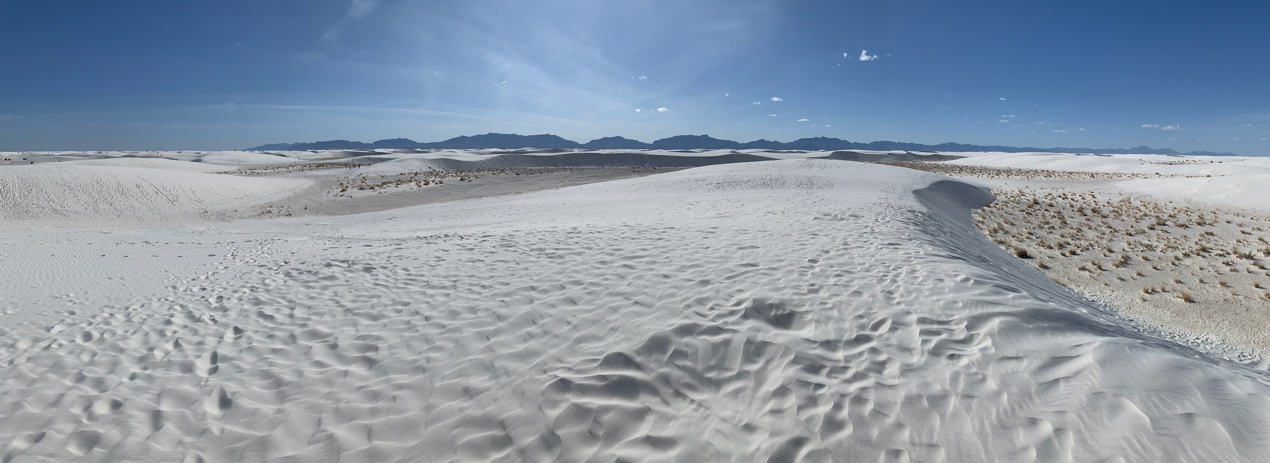
One of only three large gypsum sand dunes on earth, the others being nearby in Guadalupe Mountains NP and in Coahuila Mexico. If I had more time, I would have enjoyed camping overnight in the “back country” away from the road or a ranger lead evening program. But I enjoyed the nature hike and the otherworldly views. I was glad to have the long-range version of the Tesla Model 3, since the round trip distances to charging stations cross the vast missile range and mountains you can see in the distance.
The Triassic forests are gone, and all that remains are fossils like these. Our climate changes frequently, but extremely slowly. Sudden change is a crisis, because plants and animals lack the ability to adapt or evolve quickly. Hundreds of millions of years ago, this area was an equatorial jungle. The trees were buried by volcanic ash and sediment and soaked in mineral rich waters to fossilize, offering a rare glimpse back before the Jurassic dinosaurs.
The park film explains the distant past, the recent past and current attractions. I hope they improve their camping opportunities, so that visitors spend more time here. I enjoyed my brief time here. But it was difficult to find a car-camping campground in the area, so I moved on too quickly.
Our carbon emissions since the industrial revolution are like an asteroid strike against all life on earth. The Anthropocene, or human dominated age, has been very short, but it will be characterized by extensive global mass extinctions. And unlike a meteor, this time the devastation is entirely by choice. We know that we’re killing the plants & animals that we claim to love. But most of us apparently don’t care enough about the future to make any significant changes to save life on earth.
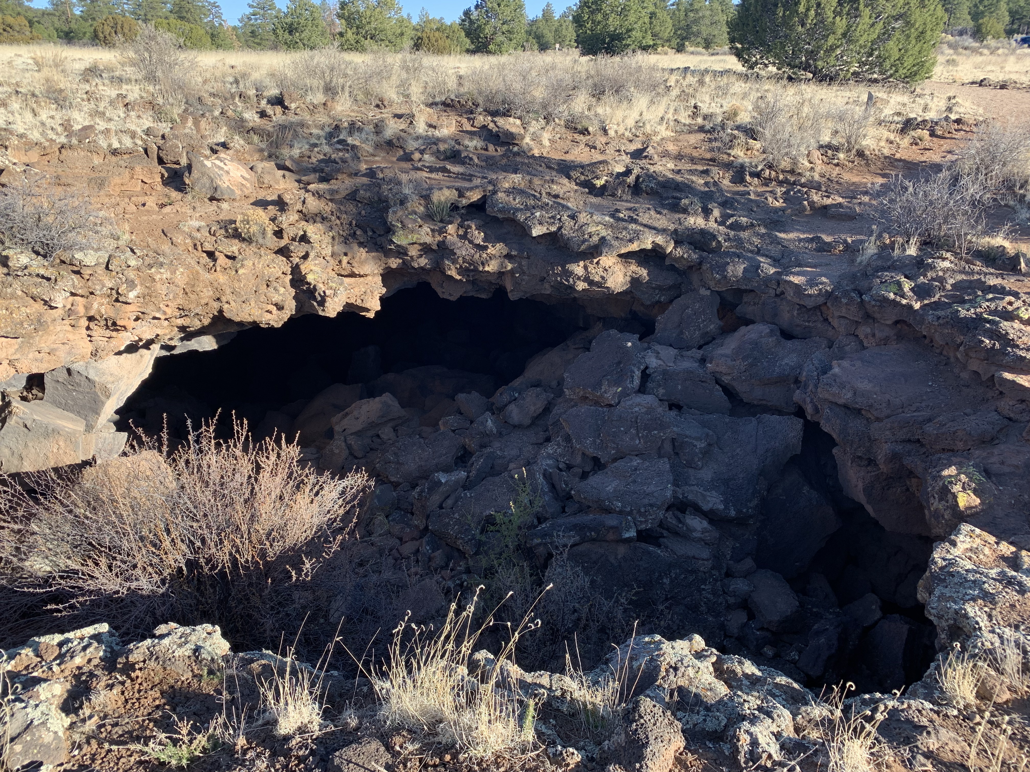
The rough terrain is filled with jagged volcanic rocks cinders, but even so, a few plants manage to live. Native Americans found obsidian near here for arrowheads and for trade.
I enjoy revisiting parks now that I travel by electric vehicle (EV), but this one was particularly good. When Pinnacles was still a National Monument before 2013 and I still traveled by burning carbon, we took the kids, but our timing was a bit off. Pinnacles gets crowded on weekends with full campgrounds and limited parking at trailheads. And the seasons are tricky. Winter can be too cold with icy roads in the hills, and summer is too hot for me, especially with our new and changing climate. Spring break is popular, and the campground pool opens on April 1st this year. Last time, we experienced both too many crowds and too much heat. After a bit of research, I decided to go mid-week at the beginning of Spring.
The biggest difference is visiting the caves at Bear Gulch. To protect the large, sensitive colony of Townsend’s big eared bats, it’s rare to be able to visit the entire cave. I remember being underwhelmed by the caves on our earlier visit and described it as being more like a narrow canyon with a few boulders stuck overhead, compared to other caves in the park system. So this time, I checked the status of the caves, and I learned that the last week of March often has full cave access, before the bat breeding season starts. And wow, it was a very different experience.
First, I hiked from the campground to save EV battery range and get more exercise. That turned out to be a beautiful hike through varied terrain with quail, wild turkeys, woodpeckers, jays, turkey vultures and other birds. But when the Gulch narrowed, I felt the cold air from underground, even before entering the lower caves. Last time, we must have taken the less-scenic shortcut. This time, I felt like a spelunker. By the time I got to the upper caves, my iPhone was in my breast pocket for light, because scrambling and ducking required both hands. It was more adventure than I expected, but fortunately, people along the way helped keep me on the path to the lovely small reservoir at the top. Well worth revisiting!
“An elf will go underground, where a dwarf dare not? Oh, I’d never hear the end of it.” — LOTR
I wrongly assumed that this preserve was just a flat sandy desert, but it is a varied terrain of mountains, mesas, canyons, and volcanic landscapes, in addition to sand dunes.
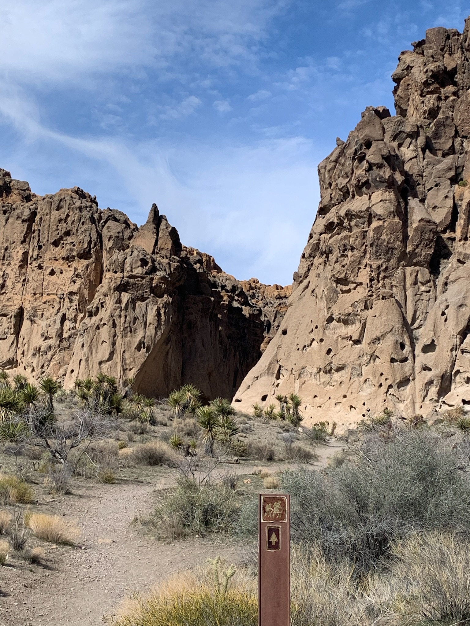
The Rings Loop Trail pictured, near the Hole-in-the-Wall visitor center, goes right through a canyon with Swiss-cheese holes in the walls. There are petroglyphs to see, fascinating views, and short ladders of iron rings to climb.
A couple of retired campers asked me about my long range Tesla 3. The recent spike in gas prices ($7 in California) interests people who regularly spend over $100 to fill their tanks. Of course it’s also a very fun car to drive with a low center of gravity and instant acceleration. But too many folks resist change, even when their carbon travel habits contribute to devastating change.
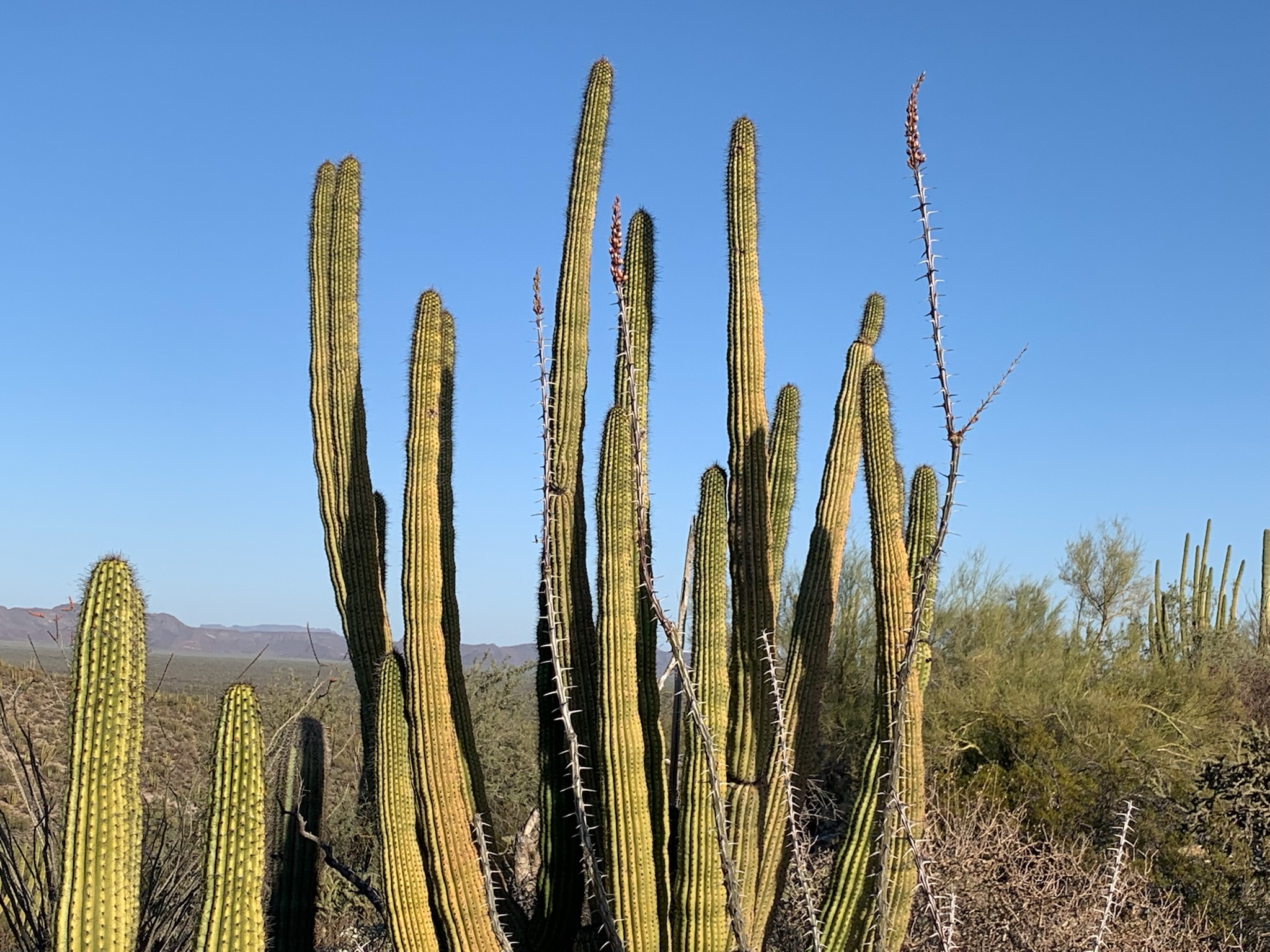
The skinny shrub reaching up in front of the cactus is Ocotillo, just beginning to bloom.
The ranger asked good questions. Given that we live in the Anthropocene or Human epoch, what exactly does wilderness mean to us now? This was one of my favorite ranger talks.
There’s a tiny endemic fish living in a corner of this park near the Mexican border. But because groundwater levels are now dropping sharply, the Quitobaquito pupfish’s natural habitat could disappear within a few years.
Some local school kids helped build a pond behind the visitor center to try to save the pupfish. The park service is re-lining the original Quitobaquito Springs to try to retain more water, but the springs are shrinking. People have been impacting the environment here for over 10,000 years, and, whether we like it or not, the little fish is now dependent on whether we choose to save it.
Ranger Kate asked the campers what we should do. The most common questions were about whether the Mexicans were at fault by siphoning off “our” water. They are actually on a different aquifer south of the Sonoyta River. And that jingoistic attitude really misses the point of being in an International Biosphere, next to the Pinacate y Gran Desierto de Altar Biosphere Reserve in Mexico. We’re supposed to be sister parks working together to save an internationally important natural area.
One suggestion was to “relocate the fish to a more viable habitat”. But if you take the pupfish out of Quitobaquito, are they still really Quitobaquito pupfish? Zoos don’t really prevent extinction in the wild.
I voted to add water to maintain the habitat. People think nothing of draining a river for a new golf course community and destroying ecosystems by burning fossil fuels. So why not reverse that destructive and short-sighted attitude and take this one chance to spend a few dollars to save a species?