[Quick note: beginning next week, Thursday and Saturday posts are both moving to Friday].
Polar bears are among the most charismatic species to be threatened by the climate crisis, which sadly is driving high-carbon tourism to see them before they become too few or far away. When the ice melts, the polar bears can’t reach their primary prey, seals. The effects of carbon pollution are currently warming the arctic quickly, and many bears are starving while they wait for the ice to return. One of the most popular spots to see wild polar bears is in Churchill Manitoba in Canada, and most visitors arrive by plane, usually taking at least two flights to get there. Once here, they take large tundra buggies or even helicopters out to see the bears gathering on the shore of Hudson Bay.
Bear viewing peak season is short, between the first snow fall in October and when the ice is thick enough for hunting. Come too early, you won’t see the bears; come too late, and they’re all out to sea. Still, you might see beluga whales or the northern lights. Besides tourism, there’s a lot of scientific research conducted up here, describing in detail how our rapidly changing climate is disrupting the lives of various species, especially the polar bears at the top of a fragile food chain. The scientists obviously understand the implications, and they offer virtual tours and are working on electric tundra buggies to try to limit the carbon pollution of tourism.
Even though this is not a world heritage site—and I’m not a carbon jet-setter—seeing polar bears in their natural environment is irresistible to me. Concerned about contributing to the carbon pollution that threatens polar bears with extinction, I decided to drive my EV up to northern Manitoba and take the train to see them, instead of flying. The town of Churchill on Hudson Bay has no road, so I drove to the regional center of Thompson to catch a 16 hour train ride to Churchill. Even Thompson is challenging for an EV, as it is 239 miles from the next closest charger.
Churchill—named for an illustrious ancestor of the UK’s wartime Prime Minister—has a Hudson Bay Company fort, a shipwreck, a small museum of the people who have lived here for ~3,000 years, and a brief-stay polar bear jail—for bears that won’t keep out of the town. While it took me longer—and cost far less than a package tour—, I made it to Churchill, taking a guided van tour into Wapusk national park, and I saw them, real polar bears living in the wild—a dream come true.
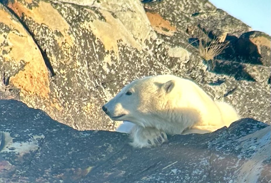
Above is a young male polar bear we observed chilling on the rocks and later walking to the water. I also saw a couple of arctic hares and dozens of Ptarmigan, an arctic or alpine bird with feathered feet. Below are a mother and cub who were resting in the sun, occasionally looking up curiously. I hope people make an effort to reduce their carbon pollution, so that these magnificent animals aren’t wiped out forever by our thoughtlessness.