Trail of Tears National Historic Trail

The trail is a crime scene, but we must remember, understand, judge and commit ourselves to being better. In the early 1800s, the Cherokee, Chickasaw, Choctaw, Muskogee (Creek) and Seminole tribes in the southeast were trying to balance their own culture while adapting to new ways of life. Sequoyah had created a Cherokee alphabet by 1821, and many had assimilated into the new communities, often through intermarriage, building homes, farms and businesses alongside immigrant families.

But many voters (at the time white males) had deep racist fear and hatred of Native Americans (and also wanted their land), so they voted for politicians who would remove the tribes. Andrew Jackson had a successful political career, and purchased a plantation and over a hundred slaves to work it. Appointed a colonel in the Tennessee militia, he gained national fame during the War of 1812–an expansionist war of choice against Native Americans and their British backers: “Remember the Raisin”. Jackson led troops including regiments from some of the five ‘civilized tribes’ above in the slaughter at Horseshoe Bend in 1814. One of his soldiers was Sequoyah, who saw first hand how the rebellious ‘Red Sticks’ were cut down by superior weapons. Jackson used the victory to betray his Native American allies by forcing the Muskogee who had fought on both sides to cede almost half of Alabama and much of southern Georgia in the 1814 Treaty of Fort Jackson.

Within 10 years of Horseshoe Bend, the Chickasaw had ceded 1/2 their territory, along the Mississippi River in western Kentucky and Tennessee (between Shiloh and Fort Donelson), retaining much of northern Mississippi (around Brices Cross Roads and Tupelo). The Choctaw lost their land near Vicksburg, and lived south of the Chickasaw. The Muskogee were restricted to a fraction of their land around Horseshoe Bend in eastern Alabama (around the Freedom Riders Monument). The Seminole had lost around 1/2 of Florida and lived in the swampy center. And the Cherokee still held their land in the mountainous corner of Alabama, Georgia, Tennessee and North Carolina, from Little River Canyon—which became a waypoint on the trail—and Russell Cave—which had been continuously inhabited for 10,000 years—, to Kennesaw Mountain and Chattahoochee River up to Chickamauga and Chattanooga, and up to the Smoky Mountains. (Yes, much of the Civil War was fought over land stolen from natives 50 years earlier).

Jackson is remembered for winning the Battle of New Orleans, but we should also remember the aftermath of the War of 1812, which ended when John Quincy Adams negotiated the Treaty of Ghent. Spanish Florida had been allied with the British, who had forts on the Panhandle. When they withdrew, they gave over one fort to a group of Seminole and African Americans. This became known as the ‘Negro Fort’ which caused great concern among those who benefited from slavery in the southeast. General Jackson sent in forces, and the fort was leveled when a cannonball hit the powder magazine. The Seminole Wars continued for decades, and the history of natives, African Americans and negotiations over Florida is fascinating.

Adams, who supported financial compensation for the five tribes, won a contingent election for President in 1824, but then Jackson defeated Adams overwhelmingly in 1828 and was reelected in 1832. As President, Jackson refused to follow a Supreme Court ruling in favor of the Cherokee, and he supported segregation of natives and both state and federal jurisdiction over native land. Jackson supported and signed the ‘Indian Removal Act’ of 1830, intending to remove the five tribes from their remaining land. Tens of thousands of Cherokee, Chickasaw, Choctaw, Muskogee and Seminole were removed from the southeast and relocated to Oklahoma with thousands dying on the forced migration trail: rounded up and held in forts, with few possessions, homes looted, families separated, marched under guard, some in chains, suffering cold and exposure, denied medical help, including women, children and the elderly. Stops along the way included Arkansas Post, Little Rock, Pea Ridge and Fort Smith in Arkansas and Wilson’s Creek in Missouri.

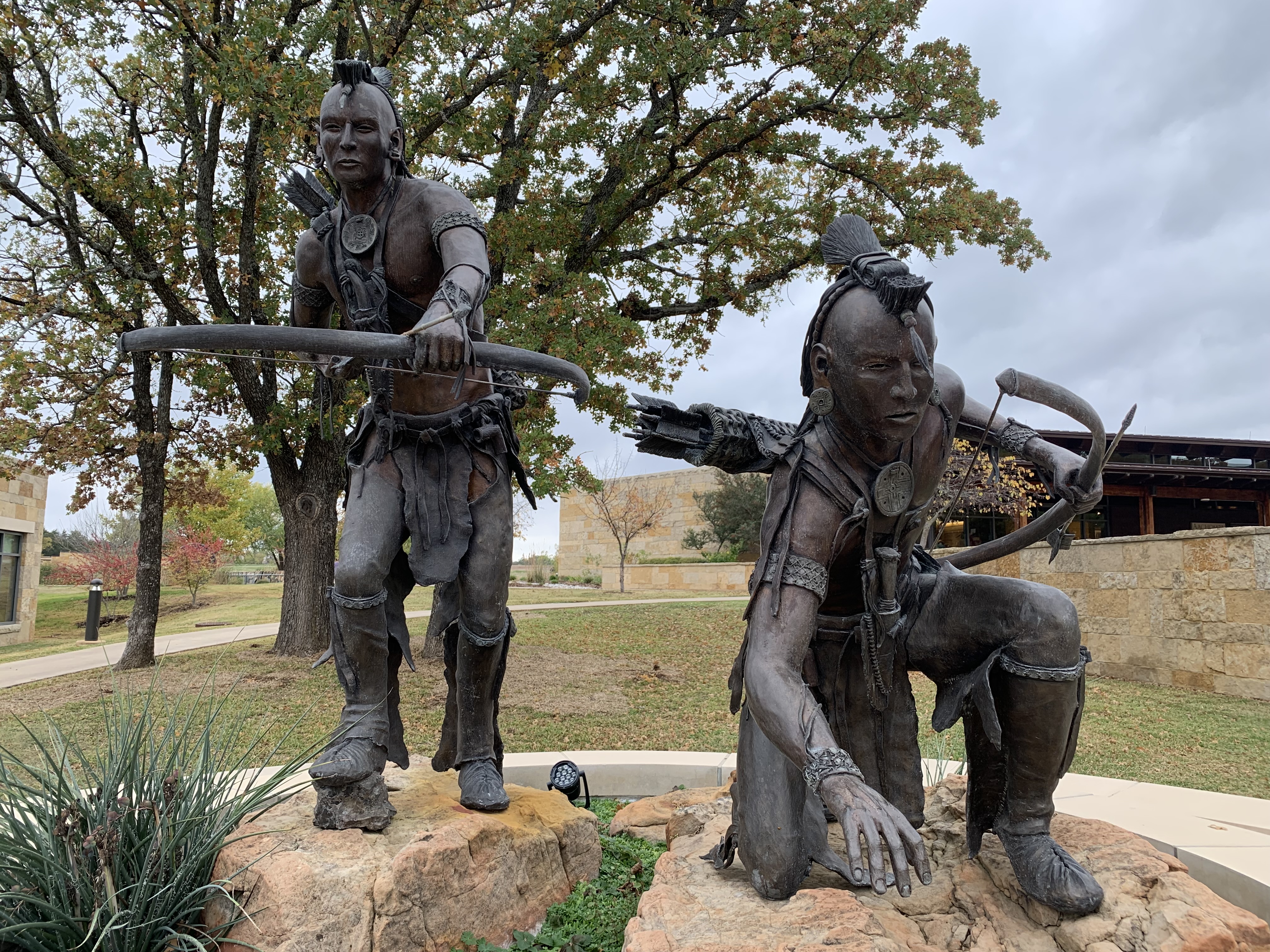
The historic trail focuses on the Cherokee, but the removal act was for all tribes east of the Mississippi. The Chickasaw (see photo above) were able to sell some of their land and moved first. The Choctaw were cheated by treaty but moved too. Many Seminole continued to fight, with some moving to Oklahoma and others to reservations deeper in central Florida. The Muskogee ceded their public land to Alabama, and Jackson refused to defend their private property from being stolen. The rest moved after the Creek War of 1836. The Cherokee also lost their land that year in a treaty their leaders didn’t sign. Jackson used bribery, fraud, intimidation and war to effect the removal. Over 70,000 Native Americans living east of the Mississippi, including the north, were removed under his policies for 8 years and enforced by his Vice President and successor Van Buren.

Some of the Cherokee hid in the mountains, and their descendants still live in towns like Cherokee, on the southern border of Smoky, where you can see signs in Sequoyah’s written language. Eastern Oklahoma territory became tribal reservations for the Cherokee in the north, Chickasaw in the south, Choctaw in the southeast and both Muskogee and Seminole in the middle. Today, the tribes there thrive, have found ways to come to terms with the trail’s brutal history and have chosen to move forward. This is an inspiring example to face the facts, recognize the evil acts and resolve to be better people.

Lewis and Clark National Historical Park

The replica of Fort Clatsop, winter camp 1805-6, above helps imagine the rough conditions for 32 men, a woman, her baby and one dog, when it rained or sleeted 94 days out of 105. Several visitors brought their Newfoundland dogs in a regular event to honor Seaman, the valued, four-legged expedition member.

Jaden and his friend—not yet park service employees—explained the story of the stolen canoe, the eating of dogs and how Sacagawea was purchased and impregnated around age 15 by her ‘husband’ who had other ‘wives’. These facts didn’t make my history book. Jaden’s canoe story was one of the best talks I’ve heard in any national park.

I missed the guided paddle trip, but I walked to Canoe Landing and saw most of the short Lewis & Clark ‘river’ from shore. The pilings in the water here and in much of the Pacific Northwest are old logging organizers.

The park also includes various nearby sites visited by the expedition, including Washington state’s Cape Disappointment—misnamed by someone who mistakenly thought the bay too large to be the mouth of the Columbia River. A Japanese sub briefly bombed Fort Stevens on the Oregon side. The charming seaside town of Astoria, once famous for furs, canneries and The Goonies, makes a good base to explore with some good restaurants and reasonably priced hotels.

Fort Vancouver National Historic Site

Portland Oregon has always confused me geographically. What kind of port is over 100 miles from the coast on a tributary of a major river? The history of this site explained it. George Vancouver, a British explorer who sailed with Captain Cook, explored the Pacific Northwest coast in the 1790s, and both the both the huge natural harbor in British Columbia to the north and this deep water site to the south on the Columbia River were named after him. Vancouver Washington was perfectly located at the confluence of the Willamette River to be an inland trading post still reachable by ocean vessels. The Chinook have long lived here and traded with other tribes, regularly traveling hundreds of miles by canoe. When the Pacific Northwest was British, this was all one territory from Sitka Alaska to San Francisco. Portland was built later as Vancouver’s port. When it became US territory, Oregon and Washington states split the growing city here on the Columbia. As the Willamette (Wil-AM-it) Valley developed in Oregon, Portland became the city and Vancouver became the tax-dodging suburb (lower income taxes in Washington within easy bridge distance to lower sales taxes across the river in Portland).

The British Hudson Bay Company built its corporate territorial headquarters here in 1825 to capitalize on the fur trade with tens of thousands of local Native Americans and a great many more via their ancient trade routes along the coast, up the rivers and deep into the mountains. The British contracted with many French fur traders who typically married natives. British ships brought workers from Hawaii after rounding Cape Horn. The fort (reconstructed on location above) was the center of a thriving cultural melting pot that developed its own language and challenges. Unfortunately, many natives died of disease, particularly malaria, which the ‘gentlemen’ who lived in the fort knew could be treated with Quinine, which they had in limited quantities. The company man in charge, Dr McLoughlin, was married to a biracial woman, and he was violently furious when newly arrived missionaries spoke derogatorily of her.

McLoughlin nevertheless extended credit to the many destitute white settlers who arrived on the Oregon Trail. He lost money, was forced to retire, became a US citizen and is now considered the ‘father of Oregon’. His house is part of the site south of Portland. White settlers took over and made the state ‘whites only’ by law until 1926, prohibiting others from property ownership etc. It’s worth reflecting honestly on this history when considering the recent Supreme Court decision against affirmative action: white ‘pioneers’ gave themselves every legal and economic advantage possible, from slavery, to the Rogue River Wars against natives, to ‘whites only’, to the Chinese exclusion act, and to taking property during the Japanese internment. It’s shameful that the Court ignored the long history unfair privileges given to white people—many whose families benefited over two hundred years from stolen land, labor and opportunity from so many people of color—and decided against providing a few seats in college in order to enrich the diversity of education for all students.

Nez Perce National Historical Park

The visitor center in Idaho is on a hill above where the Lapwai Creek flows into the Clearwater River, which joins the Snake River a few miles downstream in Lewiston. The river banks were an excellent place for salmon, berries, edible flowers, and game, and the Nimiipuu used to arrive in the fall and stay through winter. By summer, they would be hunting up in the hills, forests & mountains. French trappers called the tribe Nez Perce or ‘Pierced Nose’, although that wasn’t a traditional tribal practice. When Lewis & Clark passed through, the Nimiipuu assisted the expedition and helped them make canoes. When the missionaries and other settlers arrived, they were forced to change. Many tried desperately to compromise and adapt. After the nearby Whitman mission ended in a massacre, racist demagoguery fueled far more excessive violence across the west, bringing the US military, war, exile and restricted reservation life, including here around the Spaulding mission, pictured circa 1900.

The affiliated Nez Perce National Historic Trail, which marks the flight of the tribe from the US Army, is now part of the broad official Nez Perce NHP, including Big Hole in Montana, a refuge near Lake Roosevelt, the White Bird & Clearwater Battlefields, through Lolo Pass, Yellowstone, Billings and up to Bear Paw Battlefield. Over the years, I’ve visited these places on roadtrips, read several of the books, from I Will Fight No More Forever to Chief Joseph & the Flight of the Nez Perce and pondered the mistakes and tragedy. There is simply no excuse for breaking treaties, stealing land, or killing defenseless people, including women, children, the elderly and infants. When leaders take advantage of popular anger to focus attacks against a community, the result is often far more evil than any original sins. I encourage you to learn more, since the problem of demagoguery is still with us.

But the Nez Perce tribe is still here with us, like the flowers they used to cultivate here. They are re-learning the language that they used to be punished for speaking. They self-govern, petition the US government, sing songs, dance, teach their kids to gather plants, hunt, fish and carry on their cultural traditions and exercise their treaty rights. The lessons of their forefathers and their oral traditions continue to be remembered, spoken aloud and passed down to future generations. The park preserves petroglyphs, artifacts and sites of mythology. Their culture is vibrant and contributes a valuable perspective to all of us. They are not doomed to be permanent prisoners of tragedy, and the park film here is a refreshing reminder of the resilience and life of their culture and of the human spirit.

Whitman Mission National Historic Site

The Cayuse had heard from the east about what happened to natives after settlers arrived, so they predicted death, loss and suffering were on their way. The Whitman missionaries left in 1836, five years before others started arriving overland in Oregon. They were allowed to start a farm here, and with the fervor of the second awakening, they preached that the Cayuse were going to hell after death unless they adopted Christianity. As it turned out, gathering newly arrived settlers and native converts in church weekly to break bread and sing songs together, helped spread diseases like measles that killed most of the native population. So the Whitmans were sort of correct, except for the order: first they adopted Christianity, then they went through hell before finally dying.

Unfortunately for the missionaries, the natives had a tradition of killing bad medicine men. Now, much has been written of the Whitman massacre (especially by the other missionary Spaulding who settled nearby with the Nez Perce), but imagine if immigrants come to your town and demand that you copy their strange new ways and beliefs, with threats if you did not. Many more immigrants arrive each year, talk with the missionary doctor, take over and spread disease. When the doctor treats his own people, they usually survive, but when he treats yours, they die. How many of your friends and relatives would die before some angry grieving parent would try to kill the doctor? I’m not excusing criminal behavior based in ignorance, but similar senseless vengeful murders still occur today.

When half of the Cayuse had died of disease, a group of natives killed Doctor Whitman, his wife and 11 other men. There’s a memorial on the hill in the photo above. 5 natives were later found guilty and hung. The mass murder was a terrible crime, but the response was just short of genocide. For the next 12 years, the Cayuse and many other natives in the territories were hunted down by militias and by the military, driven from their lands, harassed and in many cases slaughtered, including women, children and the elderly. When the dust settled, most of the remaining natives were on small reservations with a few escaped to Canada. For every white person killed, hundreds or likely 1000s of natives died. More lost everything they owned, including their freedom, despite not having anything to do with the original conflict or the Cayuse.

Mississippi National River and Recreation Area

The tiny tributary (above) of the Mississippi River is Coldwater Spring, one of the few parcels of land the park service owns here except for islands. Buildings were removed, plants planted, and the birds and butterflies have already returned. A mink was sighted a few days ago. Having a good spring near the confluence of the Minnesota River made it ideal for an early trading post. Eventually the twin cities of Minneapolis and Saint Paul arose, but, even though you can hear traffic, the spot is mostly wildflowers, prairie grasses, and old Live Oaks.

The trail will be ready in September, so I wasn’t able to walk down to the floodplain to see the Cottonwoods here, but they’re visible in other locations. Nearby are the Minnehaha Falls, named after Hiawatha’s love in Longfellow’s 1/2 imagined and 1/2 native lore mashup epic “Song”. Hidden Falls / Crosby Farm and Lilydale-Harriet Island / Cherokee park partner sites are also recommended for views and other activities. The main visitor center is in the science museum and has mainly kid-friendly exhibits.

Missouri National Recreational River

“O, Shenandoah, I love your daughter,
Away you rolling river.
I’ll take her ‘cross yon rolling water.
Ah-ha, I’m bound away, ‘cross the wide Missouri.”

American folk song

Above looks upstream from the hill above Mulberry Bend in the 59 mile eastern park district, where Lewis & Clark scouted some 219 years ago, along with other places introduced by the Yankton Sioux, one of many tribes that helped the expedition. The Yankton Sioux relinquished most of their land 165 years ago before either South Dakota (right) or Nebraska (left) were states, but they are still considered defenders of Pipestone in Minnesota. Their reservation runs along the north bank of most of the 39 mile western park district, above the confluence of the Niobrara, and they are park partners. Both districts of the park preserve the natural river flow, without commercial traffic, and most power boaters stick to Lewis & Clark Lake in the middle.

Further up the ‘big muddy’ Missouri River, at the confluence of the Knife River in North Dakota, teen mom Sacagawea joined their expedition with her French fur trapper husband and their infant. Like Pocahontas, her story is part of America, and similar stories are part of our heritage. As a child, I loved the song “Shenandoah” but was confused whether it was about the Shenandoah River in Virginia or the Missouri River. Turns out, Skenandoa was an Iroquois Chief, whose daughter was stolen by a French fur trapper and taken away across the wide Missouri River. Romantic stories about natives are part of our cultural heritage, albeit often one-sided. Especially given current tragedies of missing and murdered indigenous women, more effort—and funding—is needed to protect these women and tell more stories from a Native American perspective.

Writing-on-Stone

While hiking the Hoodoo Trail, I turned to a view point above the Milk River on top of the steep cliffs above. I stopped suddenly when I heard native singing, resonating beautifully between the sandstone crevices. Not wanting to disturb the prayers, I stood silently, entranced. Eventually I retreated and continued out to the Battle Scene rock art depiction, one of the highlights of this World Heritage Site in Alberta Canada.

Later I took the guided tour of the restricted area where Blair showed and explained the rock art in this spiritual place of the Blackfoot Tribe. The tour started at 5 pm, perhaps to take advantage of the light as well as coolness. While I disagree with those who look for extraterrestrial interpretations of some of the unusual petroglyphs and pictographs, the details and 2500 years represented here are intriguing and fascinating. Still, for me, I will never forget the living voice I heard echoing among the hoodoos.

Colonial National Historical Park

This Virginia park spans the history of Colonial America, from the first settlement and seat of English government to Yorktown which marked the end of British military control. While in theory the park can be visited in a day, take two. The pretty town of Yorktown is nice with a little beach. Jamestown has several areas to see, and the park road connecting them runs through Colonial Williamsburg, which alone is worth time. This is my favorite colonial era park.

Yorktown has a very good visitor center, film and two auto tours. Even I was able to follow what happened, and long story short, the victory was as much or more French than American. Alexander Hamilton led the successful joint French & American assault on the last two key British defensive positions, one of which is eroding into the bay. The Rhode Island Light Infantry Regiment—largely African American—were critical in the assault, which employed bayonets on unloaded muskets to ensure both silence and an aggressive attack. Washington maneuvered his armies & Lafayette executed the siege in their most successful and determinative battle of the war with the assistance of the French fleet blocking the large mouth of the Chesapeake Bay. There are also remnants of the Confederate defense of Richmond on the same battlefield, although that is not the main focus of the park.

Jamestown needs explanation. Simply, there are three parts: 1) the park service Loop Road which is a swampy wooded drive or bike ride through the eastern end of the island, 2) the state’s very well funded living history settlement, and 3) the oldest Jamestowne part that has been run by a private group which predates the park service and is now an affiliated National Historic Site. All three are amazing. I saw a bald eagle, baby turtles, deer and more. At the settlement you can climb aboard recreations of all three ships, visit a Native American village, a reconstruction of the fort and an impressive museum, and there are many helpful staff throughout, some clothed in period garb, making the history extremely accessible. But don’t miss the third part, Olde Jamestowne.

This is the original remote outpost of the Elizabethan era that excited imaginations at the time, including Shakespeare whose Tempest is based on a shipwreck here. The most exciting work today is happening above in the oldest section of the park: an active archaeological dig with many world class discoveries. The fort there is built on the original fort site, and one of the archaeologists who began the dig in the 1990s gave a guided tour. There’s also a museum showcasing their discoveries.

Pocahontas married her husband John Rolfe in the church to her right, her husband witnessed the arrival of the first Africans at Fort Comfort (now Monroe), and the most recent excavation of a well is happening over her left shoulder. One of the gruesome discoveries was evidence of cannibalism among the settlers, but other discoveries speak to the diversity of the colony and its early peace with the natives, thanks mainly to the young woman above.

Fort Raleigh National Historic Site

As befits any mystery, little remains of the fabled Lost Colony of Roanoke Island NC. There is a map, a cross and “CRO” carved in a post, archaeological remains, and various accounts, both trustworthy and not. The fort above is a reconstruction. The English brought explorers, scientists, soldiers and settlers here in a few journeys in the late 16th century, but the location was deemed a failure. There was little metal, poor soil and no deep water port, and several supply ships were lost in the shallows & storms. Most of the expedition returned to England.

It was however an excellent location for piracy with many hidden coves and inlets behind the barrier islands to wait for the Spanish treasure galleons riding the Gulf Stream back to Spain with stolen Aztec and Incan gold. Many of the last colonists here had wanted to land near Jamestown, but their pirate captain dropped them here instead. When war broke out between England and Spain, Queen Elizabeth kept all English ships at home to protect against the Spanish Armada invasion of 1588. So the colonists were abandoned by the Queen for years, while they were expecting supplies within months.

Likely, they became desperate and split up with a group traveling north and others initially staying behind to wait for help. There are reports that some armed men were killed in Native American skirmishes north of here, so those remaining must have decided to go to a nearby island to seek help from the Croatoans whose chief spoke some English and had been a guest of Sir Walter Raleigh in England for 6 months. The colonists were presumed dead by the English at the time, but much later reports of a few blue-eyed Croatoans suggest at least a few survived. And the cross and letters were likely a shorthand way of letting the English know where they were without letting the Spanish know.

I arrived too early to see the stage performance here which starts in June, and I declined to pay admission to tour the Elizabethan Gardens. But the rangers and museum tell the story, along with more stories about piracy—Sir Francis Drake raided St Augustine in 1586 and brought back some Roanoke colonists on his way home—, about the Freedman’s Colony of 1862 and more modern ventures. Coming from New England, I appreciate the efforts to honor our English heritage, such as the monument here to the first English child born in the Americas. Virginia deserves more credit for being the first English colony, after all, Captain John Smith named ‘New England’ after leaving Jamestown and mapping the north east coast. Still, it would be nice to have more information about what happened to the other ethnicities who lived here, especially the Native Americans.