I saw ducks and geese in the thousands, a flock of whooping cranes, a pair of sharp-tailed grouse, and many other birds, but they kept their distance from me. Saskatchewan has many lakes, and occasionally one will be full of birds. I also saw a young moose walking near the road, and there were bison behind fences. Since I was there during harvest, I could see the giant combines gathering grain. The self-guided driving tour gives several suggestions for exploring the area, which is mostly farms and First Nation communities. I believe there’s a visitor center opening soon.
The lake is at the center of a UNESCO Biosphere Reserve, but there’s also a popular state park camping and recreation area. So there are RVs, cabins, a beach below with a playground, mini golf, a golf course, a boat launch and even a few JetSkis, which hardly seem compatible with an internationally important bird refuge. Humans have trouble sharing our world with all the other species.
The view above of Clear Lake from the wishing well is beautiful. The Canadian biosphere includes Riding Mountain National Park and environs, including many ranches, homes and towns that proudly support the local species and clean environment around them.
I enjoyed a few hikes in the park, including a lovely marsh with floating boardwalks and over a dozen bird species, like swamp sparrow, black billed magpie and yellow-rumped warbler. (Love that birdsong app!)
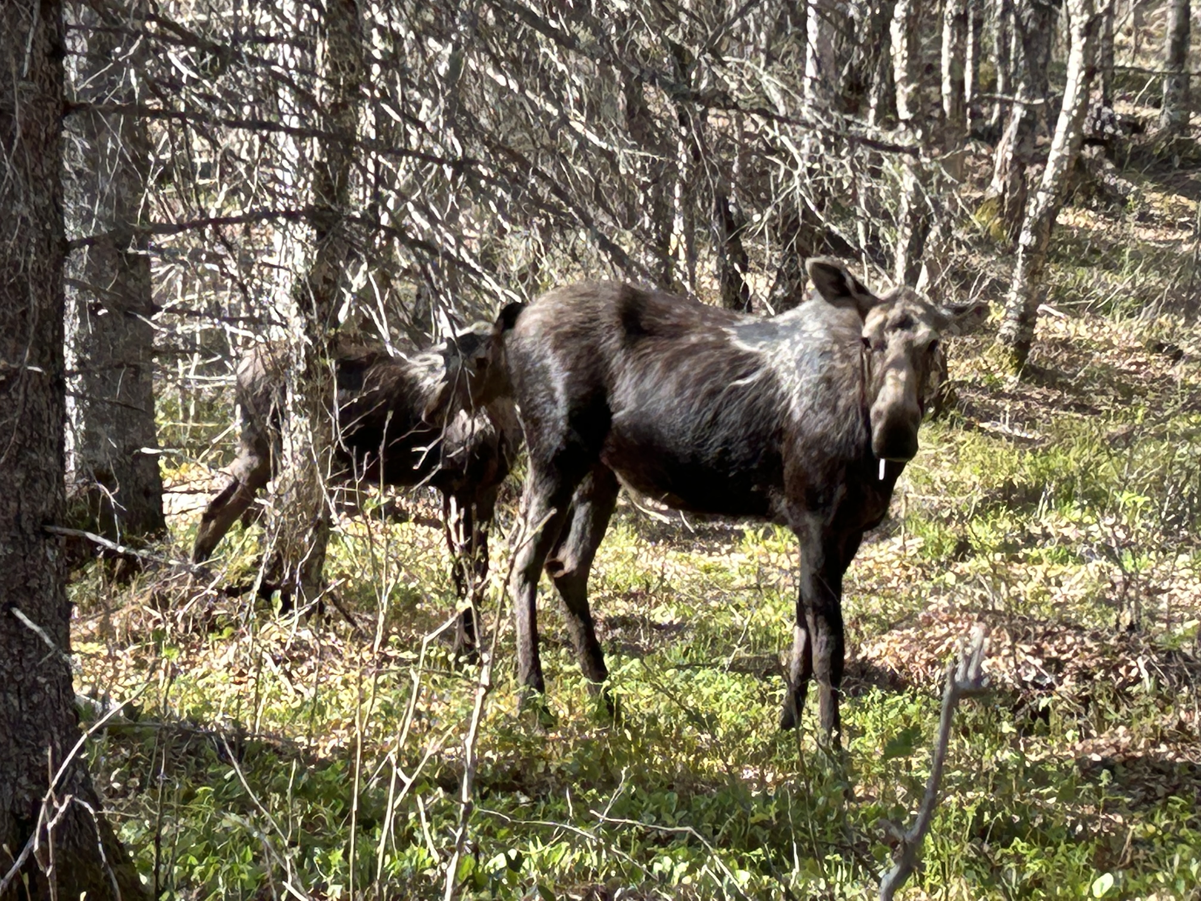
Another hike took me to a lake near Grey Owl’s cabin, before he moved to Prince Albert National Park in Saskatchewan. He was an Englishman who reimagined himself as part Native American and who spent his life advocating for wilderness conservation, especially the beaver. Interesting stories about him. Unfortunately, I didn’t see any beaver, but I did see the moose below.
Ignore the famed waterfalls and focus on Goat Island cliff in the middle. That wall is the Niagara Escarpment, caused by relatively hard rocks at the top holding the land underneath together, until it erodes away from the side. This two level land break—all erosion and not earthquake fault—is the key geologic feature to understanding the Great Lakes.
Much of the escarpment is in Canada, and even where it crosses the border to form Niagara Falls, it’s easier to see from the Canadian side as above. It runs along the south shore of Lake Ontario, across Niagara Falls (above) where it sets the level of Lake Erie, northwest through Ontario where it guides the Bruce Trail, up along the north shore of Lake Huron where it splits off Georgian Bay and shapes Lakes Huron and Michigan, along Michigan’s Upper Peninsula where it separates Lake Superior, and down the Door Peninsula past Green Bay in Wisconsin. After driving around the Great Lakes, it’s apparent how the water levels depend on the escarpment: Superior is the highest above both ends, Michigan and Huron are the same level in the middle, and shallow Erie is a little lower, held back at Niagara Falls, before that river drains into the lowest lake, Ontario.
UNESCO defines the Biosphere as the mostly forested area of Ontario between Niagara Falls and Tobermory on the tip of the Bruce Peninsula next to Georgian Bay, roughly 500 miles along the escarpment. The geologically interesting landscape holds great biodiversity in wetlands, coastline, deciduous & conifer forests, and rocky bluffs, perhaps the most in Canada. And there are many opportunities to explore, photograph wildlife, hike, drive or boat nearby. I hiked on the Cup & Saucer Trail on Manitoulin Island, the world’s largest freshwater island, when traveling around the Great Lakes. There, the escarpment is eroded on both sides, providing many views along its edge, including Lake Manitou below.
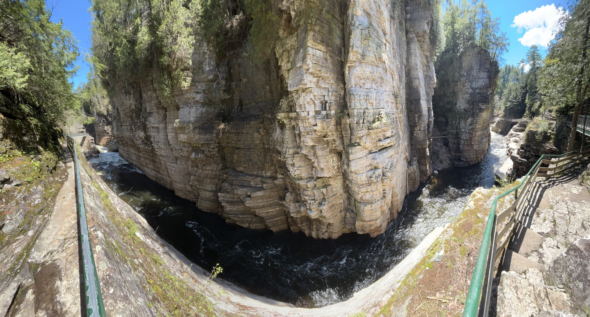
Much of upstate New York belongs to the Adirondacks, with old mountains, lakes, forests, wildlife and scenery. Two of the more famous tourist spots are the High Falls Gorge (above) and the Ausable Chasm (below), both on the Ausable River—from the French ‘au sable’ meaning ‘sandy’—which is fed from Lake Placid and flows down to Lake Champlain. Since they’re well developed old trails, walking along the secure walkways and overlooks costs about $20 each, but I think they’re still worth it, though neither is quite the scale I imagined for the ‘Grand Canyon of the East’.
Lake Champlain is part of the water route from New York City to Quebec, so several key battles were fought in the area, including at Saratoga and during the War of 1812. The British were winning in 1814, having sacked DC, but Thomas Macdonough won the Battle of Lake Champlain aboard his ship, the USS Saratoga, thwarting a British invasion down the Hudson in 1814.
This National Heritage Area preserves both history and beautiful nature, including Marsh-Billings-Rockefeller in Vermont. The Champlain-Adirondack Biosphere is also recognized by UNESCO for its forests, wetlands and mountains in both upstate NY and about 1/2 of Vermont. Unfortunately, the Trump administration ended the only other UNESCO Biosphere in the North Atlantic Region at New Hampshire’s Hubbard Brook hardwood forest research. Still, there are many other fascinating places to visit in this diverse heritage area, such as the Antique Boat Museum in Clayton New York on the St Lawrence River, as well as the scenic homelands of the Algonquin and Iroquois people near the Canadian border.
This year I completed loops around all the Great Lakes, crossing the Canadian border in Minnesota, upper & lower Michigan, and western & northern New York, visiting biospheres in both countries. In Canada, UNESCO Biospheres are tourist destinations, where you can hike and see and learn about wildlife, in addition to and separately from their wonderful national and provincial parks. In the US, while some national parks are also internationally recognized biospheres, the United Nations Educational, Scientific and Cultural Organization, UNESCO, is hardly mentioned.
Obtawaing Biosphere is a university project, not well known despite its international scientific research cooperation. Isle Royale National Park attracts many midwestern volunteers for its prey-predator study (see tagged moose above), but even if you ask a ranger, you’re unlikely to learn much about the site being a UNESCO Biosphere. And it took some research for me to learn that Sleeping Bear Dunes is also part of the larger global biosphere network.
Many Americans view our parks as recreation areas for workers to take vacations and spend money as tourists. That nature thrives there is taken for granted. What’s important for most is that you can exercise by climbing a dune, hiking across an island, renting a kayak or biking on a trail. If science is considered at all, it should be presented to the kids in an entertaining, limited format, where kids can learn about ‘weird’ or ‘cool’ animals.
Canada has all of that too, but they also cooperate in international scientific efforts to protect nature. Adults are encouraged to increase their scientific understanding of species too. Their Great Lake biospheres have online visiting information, campgrounds, cooperative agreements with First Nations, birding resources, museums, and both areas that are closed to the public and where the public is welcome. UNESCO is on the signs and in the exhibits.
Sadly, a few Americans believe stupid conspiracies about UNESCO, and some leaders disparaged the science group over an unrelated Israel/ Palestine dispute. As President, Trump removed 17 US Biospheres from the UN program, including Konza Prairie in Kansas. Kansas may not be demographically diverse, but its Tallgrass Prairie is ecologically important to species diversity on earth. The research at Konza used to receive international funding and cooperate with UN scientific efforts, including climate and wildfire research.
There is no logic behind stopping us from receiving funding from the UN for many of our critically important research biospheres, when we need international cooperation to fix the climate crisis. Humans impact nature, and if we’re not careful, we will irrevocably destroy much of our natural environment. Americans should learn about and celebrate our UNESCO biospheres. Please support scientific research and the environment.
The University of Michigan Biological Station—better known as ‘bug camp’—on Douglas Lake (above) began over 100 years ago, and now, under its new Anishinaabemowin name, it is recognized as the heart of a huge UNESCO biosphere protecting species in northern Michigan. While UMBS is not a tourist destination at all, I saw groups of enthusiastic students and researchers preparing scientific experiments and data collection, various boats and a large protected forest. They are doing important research on the Climate Crisis and preparing a new generation of experts with hands on experience. We need to stop climate change denial, pay attention to the science and stop carbon pollution, before it’s too late.
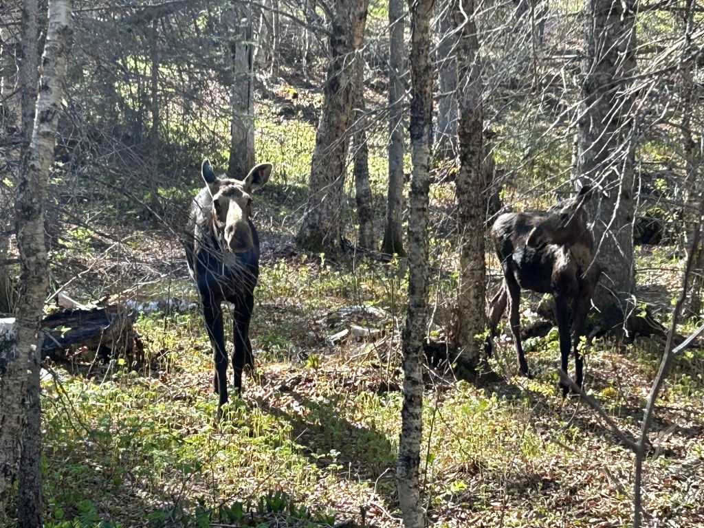
This is now my favorite park for wildlife. I was lucky to get a photo of this moose and her calf on the 1 mile Nature Trail in Windigo just before my boat left. Despite seeing loons, mergansers, swans, geese, and even a bushy tailed fox parading near my shelter on Washington Creek, I had neglected to take any decent wildlife photos, so until these two approached me, all I had was one photo of two ducks: a paradox.
I hiked a dozen miles and enjoyed the pitcher plants and boardwalks through the swampy areas and the mossy boulders on the north shore. The island is larger than I imagined, so be sure to download the park map in advance and charge your phone. This Biosphere is one of the least visited National Parks but most re-visited. Many folks hike the length over several days, and early in the season there were many volunteers hiking off-trail doing scientific research on wolf-moose predator-prey. A few were carrying a canoe for inland lakes. It’s an idyllic place, with hours of silence and solitude, a wonderful trip into the wilderness.
Isle Royale is in Lake Superior, and the shortest ferry ride is a couple hours from Minnesota to Windigo. The island is part of Michigan, and there are also ferries from the Keweenaw Peninsula in Upper Michigan to Rock Harbor. Most visitors are experienced hikers who backpack to their campgrounds, and it’s 40 miles between Windigo and Rock Harbor. Some arrive by private boat, and several campgrounds have docks. Lodgings are limited to Rock Harbor and a couple cabins in Windigo, and rooms are both very expensive and typically sold out many months in advance. The season roughly runs from early June to early September, so it’s a good idea to plan your trip a year in advance.
Technically, the name of this UNESCO World Heritage Site is Agave Landscape and Ancient Industrial Facilities of Tequila. But that’s a mouthful. For at least 2,000 years, folks around here have been making pulque, a milky agave wine. A wealthy Spanish aristocrat, working around a royal ban on new vineyards, started distilling blue agave, inventing a new drink named after the town of Tequila in Jalisco state. Above are Tres Mujeres oak barrels aging tequila for years, to the sound of classical music, which is thought to improve the taste.
But wait, trendy folks claim they don’t like tequila and only drink mezcal, which is silly since tequila is a type of mezcal. Mezcal is a very broad category of alcohol, including home brews, stuff sold in plastic containers out of the trunks of cars, and a few quality refined spirits, like tequila. Some mezcals use extra wood burning to add more smoke flavor, but good tequila just uses the cooked agave fruit and the smokiness from the barrel. Some tequilas add food coloring, but good tequilas similarly gain their color naturally.
Another misconception is that like champagne, all tequila must be made near Tequila in Jalisco. That’s not true. Tequila can be made anywhere in the state of Jalisco and also in designated areas of half a dozen other states in Mexico. We did a tequila tasting many years ago out of Puerta Vallarta, and it was as authentic and delicious as the ones near Tequila. Even the heritage site covers several different towns west of Guadalajara.
Between Tequila and Guadalajara is a UNESCO Biosphere, La Primavera or ‘springtime’, which includes a pine-oak forest, springs, orchids, birds and more, and it’s a popular recreation area. Tequila is my last stop in Mexico for a while—quite an enjoyable one—, so now Mondays switch back to US park units, affiliates, trails and heritage areas. Thanks for reading!
Biospheres are important ecological areas around the globe for protecting species diversity and for learning how to best sustain development ecologically, economically and socially. Science and solutions learned in each area are shared globally through the United Nations, and this is particularly important now that we face a global climate crisis. UNESCO currently recognizes three biospheres in the Rocky Mountain Region, and up to 2017, there were five more described below.
The Rocky Mountain Biosphere in Colorado roughly encompasses Rocky Mountain National Park and some of the Rocky Mountain Wilderness to the north. Some of the charismatic species in the biosphere are Bighorn Sheep, Elk, Mountain Lions, Pika and Snowshoe Hare. Scientists have studied species that have been wiped out of the area, like the Grizzly, Gray Wolf and Bison, as well as species that have moved in, like Moose. The exceptionally high altitudes define unique ecosystems of global importance.
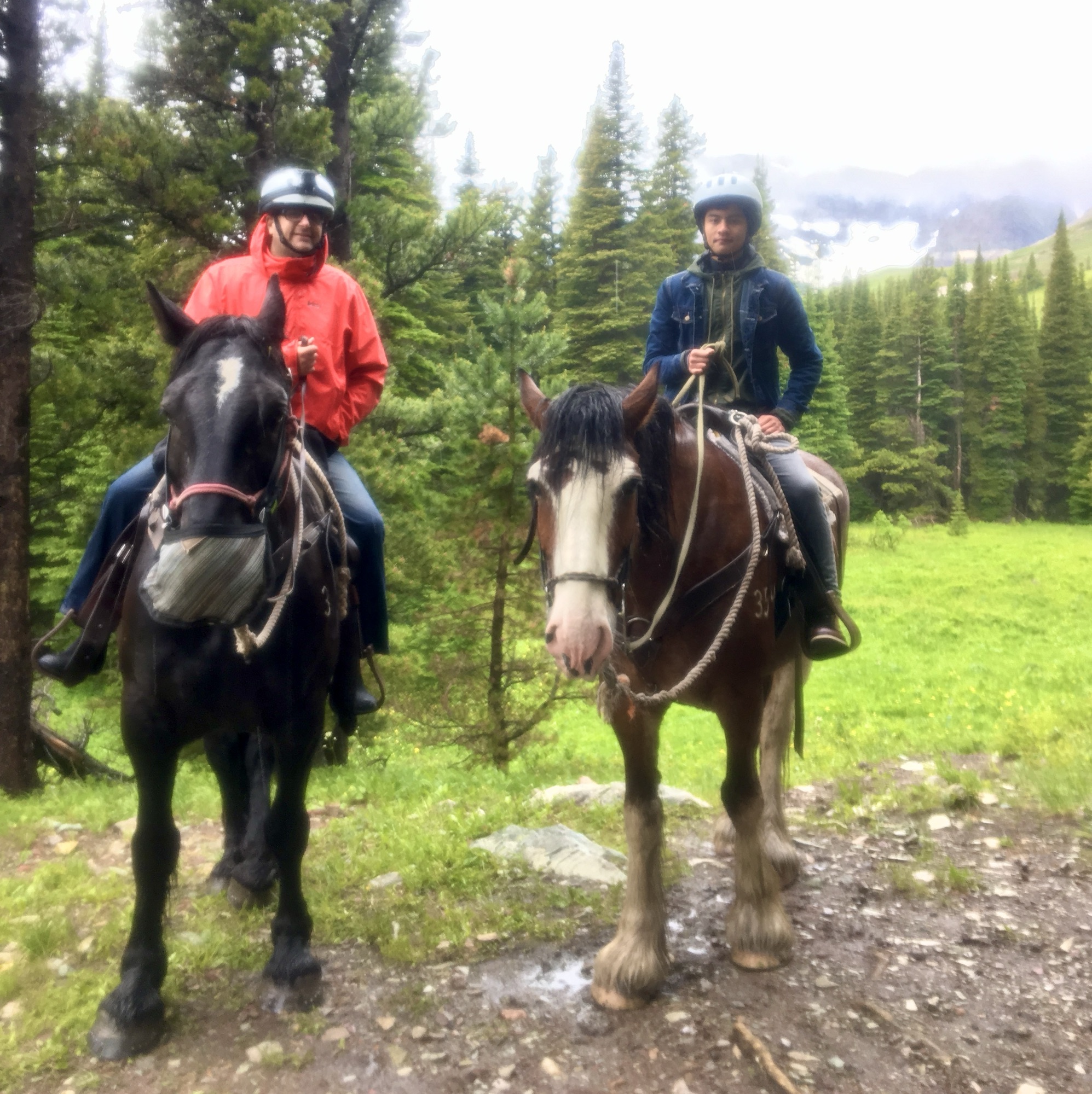
The Crown of the Continent Biosphere in Montana includes Glacier National Park (see photo of author & son above). (Perhaps to de-emphasize the shrinking glacier problem, the Biosphere dropped the name “Glacier” in 2017). The biosphere is home to rare charismatic species like Grizzly Bears, Lynx and Wolverines. Over 100 years of scientific data on wildfires, snowpack, species populations, and more have been collected and shared from this park and its sister park Waterton Glacier in Canada. Like Rocky Mountain, the biospheres here cover the Continental Divide, which defines the direction of rivers across the US to the Atlantic & Pacific, but from here rivers also flow north to the Arctic, making these biospheres of particularly important for studying migrating species.
Yellowstone-Grand Teton Biosphere in Wyoming obviously includes Yellowstone and Grand Teton National Parks. One of the most intact predator-prey-scavenger biospheres on earth, with large herds of Elk and Bison, Grizzly Bears, Cutthroat Trout and Bald Eagles, and unrestricted rivers, this is an exceptionally important global biosphere.
Unfortunately, in 2017 the Trump Administration canceled 5 other biospheres in the Rocky Mountain Region. Apparently, the Israelis were upset that Palestinians were allowed to participate in UNESCO and used the place name “Palestine” in the name of a joint heritage site, so the US ended over forty years of scientific cooperation and research sharing with the world and removed many US biospheres from the global program.
The programs canceled in 2017 included three in Colorado: Central Plains Biosphere in the northeast, Fraser Biosphere in central, and Niwot Ridge Biosphere in the north. The Central Plains was particularly valuable in the study of short grass prairie ecosystems. Fraser was important in studying the interaction of forests, rivers and climate. Niwot Ridge contributed important research into alpine tundra ecosystems, glaciers, high altitude plants and climate change.
In Montana, the Coram Biosphere, west of Glacier NP ended in 2017. Coram was important in the study of forest regeneration and forest management. And in Utah, the Desert Biosphere, near Great Basin also ended in 2017. Desert, begun by President Hoover, contributed to our understanding of scrublands and pasturelands in hot and dry areas.
I’ve traveled in, through or next to all five canceled Rocky Mountain biospheres in my electric car, and they’re also uniquely beautiful places. But biospheres aren’t primarily meant for tourists, they’re meant for nature and for scientists. While some research continues at many of these sites, the international scientific and policy management cooperation was cut off. Especially facing a global climate crisis, we need to be actively cooperating to find global solutions to our ecological threats. Also, it seems bizarre to remove our own natural scientific research areas from participation in international science, due to deep-rooted political feuds in the Mideast. I hope these irrational mistaken biosphere withdrawals can be reversed by the current or future administrations, so that the global learning can continue.
Butterflies are free. Monarchs may arrive at their winter home late, be choosy about where to land, and may leave early. At around 10,000 feet, the dormant volcanic peaks are covered in trees and flowers, with the specific temperatures the Monarchs need. Despite the distance and dangers, the fragile butterflies still manage to fly from Canada to Mexico every year in an extraordinary migration, one of the coolest natural events on earth.
Everyone loves the monarchs, and between the states of Mexico and Michoacán the reserve is both a UNESCO Biosphere and a World Heritage Site. During the November to March season, crowds of locals take bus day trips to see them fly, cluster, feed, mate and fly again. Since the flighty monarchs are unpredictable, day trips can visit their chosen forest at the best times. Overseas visitors often stay for a few days in lovely spots—like Cerro Pelón B&B run by a family of original butterfly rangers—to enjoy the picturesque villages and relaxing environment while recovering from high altitude hiking, as I did.
Humans can impact these glorious butterflies in many ways, both positively and negatively, and we need to be much smarter about making small changes that can help: reduce pesticides, grow butterfly friendly plants and drive slower when butterflies are present. But also, we need to make big, global changes to reduce our carbon emissions, so that this species can survive.
Which brings me to an Earth Day question. Is it worth flying and driving here to see the butterflies, knowing that your carbon pollution will contribute to their extinction? Better to drive an electric car.